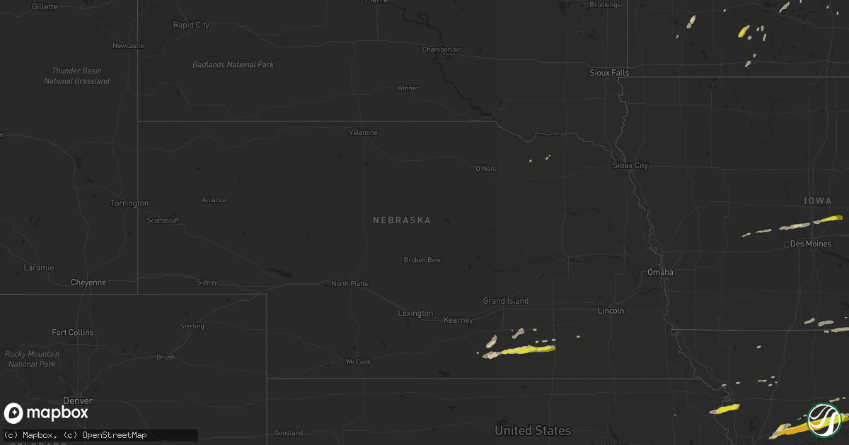
Hail Map in Nebraska on April 17, 2019
Get this storm
April 17 map
$229
one time, instant access
Download today. No call, no setup
Keep the $229
Bought the map and want the full workflow? Apply the entire $229 to a subscription within 7 days. None of it is wasted.
Every map, not just this one
This buys you this map. Subscription and you get every map we run, in the markets you choose from a few cities to whole states to nationwide. Plus real-time alerts the moment a storm fires.
Contact data
Name, contact info, occupancy, even credit band for addresses in the footprint. You go from where it hit to who to call.
Become the source they trust
Unlimited branding weather history reports on demand. You already have the documented answer ready for the property owner, and you are the one who showed up with it.
Property data and RoofTrace estimates
Pull up any address you have got, its value and the exact code rules for that jurisdiction, straight from One Click Code. Then RoofTrace estimates the squares, pitch, and roof value, priced the way you price.
Storm reports in Nebraska
Nebraska
| Date | Description |
|---|---|
| 04/17/20198:38 AM CDT | Delayed report via twitter. Time estimated from radar. |
| 04/17/20194:26 AM CDT | At 926 AM CDT, a severe thunderstorm was located near Carleton, or 35 miles south of York, moving east at 30 mph. HAZARD...60 mph wind gusts and quarter size hail. SOURCE...Radar indicated. IMPACT...Hail damage to vehicles is expected. Expect wind damage to roofs, siding, and trees. Locations impacted include... Shickley, Milligan, Bruning, Ohiowa and Strang. |
| 04/17/20193:26 AM CDT | At 826 AM CDT, a severe thunderstorm was located near Lawrence, or 17 miles south of Hastings, moving east at 30 mph. HAZARD...60 mph wind gusts and quarter size hail. SOURCE...Radar indicated. IMPACT...Hail damage to vehicles is expected. Expect wind damage to roofs, siding, and trees. Locations impacted include... Edgar, Fairfield, Lawrence, Davenport, Deweese and Ong. |
| 04/17/20192:55 AM CDT | At 755 AM CDT, a severe thunderstorm was located over Bladen, or 22 miles southwest of Hastings, moving east at 35 mph. HAZARD...60 mph wind gusts and quarter size hail. SOURCE...Radar indicated. IMPACT...Hail damage to vehicles is expected. Expect wind damage to roofs, siding, and trees. Locations impacted include... Hastings, Blue Hill, Campbell, Bladen, Roseland, Holstein, Ayr and Rosemont. |
All States Impacted by Hail Map on April 17, 2019
Cities Impacted by Hail Map on April 17, 2019
- Sanger, TX
- Dublin, TX
- Comanche, TX
- Franklin, TX
- Marquez, TX
- Shattuck, OK
- Melvin, TX
- Canadian, TX
- Union City, TN
- Martin, TN
- Rives, TN
- Cotulla, TX
- Panhandle, TX
- Amarillo, TX
- Fort Worth, TX
- Ranger, TX
- Greenville, IL
- Pocahontas, IL
- Delaware, AR
- Dardanelle, AR
- Russellville, AR
- Claude, TX
- Wellington, KS
- Gainesville, TX
- San Saba, TX
- Richland Springs, TX
- Rochelle, TX
- South Haven, KS
- Braman, OK
- Medford, OK
- Caldwell, KS
- Higgins, TX
- Early, TX
- Brownwood, TX
- Smithville, OK
- Mullin, TX
- Zephyr, TX
- Freer, TX
- Hamilton, KS
- Eureka, KS
- Wheeler, TX
- Shamrock, TX
- Sonora, TX
- Junction, TX
- Hondo, TX
- Bandera, TX
- Union City, OK
- Healdton, OK
- Ringling, OK
- Menard, TX
- Del Rio, TX
- Chico, TX
- Sunset, TX
- Weatherby, MO
- Ottawa, KS
- Garnett, KS
- Westphalia, KS
- Richmond, KS
- Williamsburg, KS
- Rantoul, KS
- Princeton, KS
- Waverly, KS
- Cheyenne, OK
- Sweetwater, OK
- Asherton, TX
- Crockett, TX
- Lovelady, TX
- Geuda Springs, KS
- Damascus, AR
- Bee Branch, AR
- Hamilton, TX
- Evant, TX
- Jacksboro, TX
- Bowie, TX
- Ponca City, OK
- Newkirk, OK
- Hennessey, OK
- Cashion, OK
- Guthrie, OK
- Crescent, OK
- Atkins, AR
- Jerusalem, AR
- London, AR
- Dover, AR
- Hector, AR
- Bladen, NE
- Blue Hill, NE
- Winfield, KS
- Arkansas City, KS
- Oxford, KS
- Saint Jo, TX
- Perrin, TX
- Forestburg, TX
- Decatur, TX
- Bridgeport, TX
- Paradise, TX
- Alvord, TX
- Charlotte, TX
- Jourdanton, TX
- Gerald, MO
- Leslie, MO
- Leon, KS
- Kenton, TN
- Quemado, TX
- Brackettville, TX
- Uvalde, TX
- Batesville, TX
- Sabinal, TX
- Bethel, OK
- Hodgen, OK
- Broken Bow, OK
- Mountain Grove, MO
- Houston, MO
- Cabool, MO
- Duenweg, MO
- Carthage, MO
- Joplin, MO
- Elkhart, TX
- Reydon, OK
- Briscoe, TX
- Brady, TX
- Independence, MO
- Buckner, MO
- Blue Springs, MO
- Nocona, TX
- Hunt, TX
- Mountain Home, TX
- Leakey, TX
- Thomas, OK
- Buffalo, OK
- Madill, OK
- Floresville, TX
- Potosi, WI
- Holy Cross, IA
- Sherrill, IA
- Dyersville, IA
- New Vienna, IA
- Conway Springs, KS
- Fenton, MO
- House Springs, MO
- Eureka, MO
- High Ridge, MO
- Hereford, TX
- Dumas, TX
- Warsaw, MO
- Rose Bud, AR
- Quitman, AR
- Knippa, TX
- D Hanis, TX
- La Pryor, TX
- Oklahoma City, OK
- Muenster, TX
- Clarendon, TX
- Mclean, TX
- Laredo, TX
- Hardin, MO
- Richmond, MO
- Ava, MO
- Texola, OK
- Lawrence, NE
- New Blaine, AR
- Paris, AR
- Subiaco, AR
- Scranton, AR
- Dilley, TX
- Pearsall, TX
- Squires, MO
- Dacoma, OK
- Krum, TX
- Calvert, TX
- Guthrie Center, IA
- Sullivan, MO
- Saint Clair, MO
- Waldron, AR
- Aline, OK
- Carmen, OK
- Ozark, AR
- Idabel, OK
- Voca, TX
- Gorman, TX
- Blanket, TX
- Goldthwaite, TX
- Carbon, TX
- Lometa, TX
- De Leon, TX
- Desdemona, TX
- Stephenville, TX
- Cherokee, OK
- Burlington, OK
- Jet, OK
- Roosevelt, TX
- Lenexa, KS
- Kansas City, MO
- Mission, KS
- Prairie Village, KS
- Shawnee, KS
- Overland Park, KS
- Carterville, MO
- Diamond, MO
- Quapaw, OK
- Galena, KS
- Riverton, KS
- Sarcoxie, MO
- Baxter Springs, KS
- Webb City, MO
- Reeds, MO
- Trumann, AR
- Saint Louis, MO
- Grapeland, TX
- Havana, AR
- Kansas City, KS
- Argonia, KS
- Amorita, OK
- Rocksprings, TX
- Clarksville, AR
- Boles, AR
- Parks, AR
- Mena, AR
- San Jon, NM
- Poteau, OK
- Howe, OK
- Burlington, KS
- Gridley, KS
- Moline, KS
- Howard, KS
- Grenola, KS
- Mansfield, AR
- Booneville, AR
- Avoca, MN
- Malvern, AR
- Perryville, AR
- Masonville, IA
- Winthrop, IA
- Independence, IA
- Saint Joseph, MO
- Rushville, MO
- Lenapah, OK
- Delaware, OK
- Yukon, OK
- Saint James, MN
- Mulberry Grove, IL
- Smithboro, IL
- Waldron, KS
- Gentry, MO
- Haworth, OK
- Gage, OK
- Vanzant, MO
- Drury, MO
- Grandview, MO
- Lees Summit, MO
- Minburn, IA
- Elk Falls, KS
- Cambridge, KS
- Cedar Vale, KS
- Dexter, KS
- Fall River, KS
- Sunray, TX
- Whitesboro, TX
- Comstock, TX
- Mooreland, OK
- Bethany, OK
- Sparkman, AR
- Gurdon, AR
- Hammon, OK
- Miami, TX
- Burneyville, OK
- Marietta, OK
- Perry, OK
- Orlando, OK
- Mulhall, OK
- Stillwater, OK
- Wister, OK
- Leawood, KS
- Meridian, OK
- Mount Ida, AR
- Garland City, AR
- Fay, OK
- Taloga, OK
- Canton, OK
- Hitchcock, OK
- Oakwood, OK
- Leedey, OK
- Putnam, OK
- Custer City, OK
- Butler, OK
- Okeene, OK
- Watonga, OK
- Agency, MO
- Atchison, KS
- De Kalb, MO
- Faucett, MO
- Harper, KS
- Anthony, KS
- Haysville, KS
- Clearwater, KS
- Belle Plaine, KS
- Derby, KS
- Mayfield, KS
- Augusta, KS
- Rose Hill, KS
- Peck, KS
- Mulvane, KS
- Danville, KS
- Milan, KS
- Freeport, KS
- Camden, AR
- Kingfisher, OK
- May, TX
- Gilman, IA
- Manchester, IA
- Maumelle, AR
- North Little Rock, AR
- Groesbeck, TX
- Roseland, NE
- Holstein, NE
- Arkadelphia, AR
- Madison, KS
- Virgil, KS
- Tama, IA
- Laurel, IA
- Montour, IA
- Jewett, TX
- Centerville, TX
- Millstadt, IL
- Vandalia, IL
- Caseyville, IL
- Edwardsville, IL
- Belleville, IL
- Collinsville, IL
- Dupo, IL
- Troy, IL
- Keyesport, IL
- East Carondelet, IL
- O'Fallon, IL
- Fairview Heights, IL
- Marine, IL
- Lebanon, IL
- Highland, IL
- Saint Jacob, IL
- East Saint Louis, IL
- Nash, OK
- Collinsville, TX
- Rayville, MO
- Paola, KS
- Stroud, OK
- Chandler, OK
- Davenport, NE
- Shickley, NE
- Mason, IL
- Big Wells, TX
- Breese, IL
- Aviston, IL
- Cameron, OK
- Hackett, AR
- Heavener, OK
- Pottsville, AR
- Sherman, TX
- Kingsville, TX
- Tipton, MO
- Fortuna, MO
- Sheridan, AR
- Hale, MO
- Carrollton, MO
- Mendon, MO
- Norborne, MO
- Brunswick, MO
- Bogard, MO
- Triplett, MO
- Bosworth, MO
- Normangee, TX
- Hearne, TX
- Canyon, TX
- Tina, MO
- Lawson, MO
- Excelsior Springs, MO
- Orrick, MO
- Perryton, TX
- Magazine, AR
- Wichita, KS
- Watson, IL
- Effingham, IL
- Crystal City, TX
- Moscow, IA
- Groom, TX
- Pottsville, TX
- Polk City, IA
- Madrid, IA
- Woodward, IA
- Slater, IA
- Granger, IA
- Walnut Grove, MN
- Westbrook, MN
- Garden City, MO
- Pampa, TX
- Hattieville, AR
- Mansfield, MO
- Norman, OK
- Bloomfield, NE
- Mooresville, IN
- Thackerville, OK
- Lindsay, TX
- Rosston, AR
- Bluff City, AR
- Chidester, AR
- Savannah, MO
- Alva, OK
- Denton, TX
- Barksdale, TX
- Erick, OK
- Freeman, MO
- Drexel, MO
- Elk City, KS
- Longton, KS
- Thornfield, MO
- Delight, AR
- Peculiar, MO
- Cleveland, MO
- Lamar, AR
- Hagarville, AR
- El Dorado, KS
- Rosalia, KS
- Ramsey, IL
- Vilonia, AR
- Conway, AR
- Blanco, TX
- Houston, AR
- Wellington, TX
- Nelson, NE
- Deweese, NE
- Edgar, NE
- Fairfield, NE
- Maysville, MO
- Columbia, IL
- Fredericksburg, TX
- Harper, TX
- Madelia, MN
- Vernon Center, MN
- Amboy, MN
- Edgemont, AR
- Higden, AR
- Pilot Point, TX
- Sinton, TX
- Arnold, MO
- Saint James, MO
- Cuba, MO
- Rusk, TX
- Leon, OK
- Welcome, MN
- Fairmont, MN
- China Spring, TX
- Sayre, OK
- Elk City, OK
- Tuttle, OK
- Sedan, KS
- Medicine Lodge, KS
- Enid, OK
- Hunter, OK
- Kremlin, OK
- Carrizo Springs, TX
- Hastings, NE
- Trenton, IL
- Pawhuska, OK
- Danville, AR
- Waynoka, OK
- Wasola, MO
- Louisburg, KS
- Buffalo, TX
- Oakwood, TX
- Cedar Creek, TX
- Elgin, TX
- Rising Star, TX
- Gordonville, TX
- Marshall, OK
- Covington, OK
- Pocasset, OK
- Haverhill, IA
- Marshalltown, IA
- Amber, OK
- Mustang, OK
- Edmond, OK
- Minco, OK
- El Reno, OK
- Billings, OK
- Garber, OK
- Greenfield, OK
- Chillicothe, MO
- Gillham, AR
- Lewisville, AR
- Hamel, IL
- Toronto, KS
- Riviera, TX
- Greeley, KS
- Norwood, MO
- Fennimore, WI
- Granite City, IL
- Hartford, IL
- East Alton, IL
- Wakita, OK
- Bluff City, KS
- Manchester, OK
- Prescott, AR
- Saint Peter, MN
- Mankato, MN
- Kasota, MN
- Hope, AR
- Bucyrus, KS
- Fairfax, OK
- Augusta, AR
- Mason, TX
- Fredonia, KS
- Grannis, AR
- Lucien, OK
- Lane, KS
- Osawatomie, KS
- Cotton Plant, AR
- Raymondville, MO
- Licking, MO
- Waldo, AR
- Gardner, KS
- Spring Hill, KS
- Olathe, KS
- Currie, MN
- Ong, NE
- Glenvil, NE
- Butterfield, MN
- Bradleyville, MO
- Seymour, MO
- Kosse, TX
- Greenbrier, AR
- Plainview, AR
- Wilson, OK
- Kingston, AR
- Witter, AR
- Coyle, OK
- Perkins, OK
- Umpire, AR
- Helena, OK
- Tioga, TX
- Rolla, MO
- Edgewood, IL
- Lebanon, MO
- Mabelvale, AR
- Bauxite, AR
- De Queen, AR
- Lohn, TX
- Dundas, MN
- Northfield, MN
- Eureka Springs, AR
- Rogers, AR
- Falmouth, IN
- Sadler, TX
- Volga, IA
- Elkader, IA
- Strawberry Point, IA
- Cambridge City, IN
- Connersville, IN
- Milton, IN
- Hawkins, TX
- Atalissa, IA
- West Liberty, IA
- Stockton, IA
- Cameron, TX
- Mount Judea, AR
- Lerna, IL
- Charleston, IL
- Bartlesville, OK
- Colony, KS
- Latham, KS
- Piedmont, KS
- Roland, AR
- Unionville, MO
- Cincinnati, IA
- Powersville, MO
- Corydon, IA
- Seymour, IA
- Wilton, IA
- Bells, TX
- Clifton, TX
- Geneva, NE
- Belleville, AR
- Newcastle, OK
- Blanchard, OK
- Allerton, IA
- Clio, IA
- Lineville, IA
- Foss, OK
- Bonham, TX
- Tipton, IA
- Maxwell, IA
- Cambridge, IA
- Montrose, IL
- Teutopolis, IL
- Panora, IA
- Linden, IA
- Dawson, IA
- Yale, IA
- Wickes, AR
- Whitewright, TX
- Tom Bean, TX
- Luxemburg, IA
- Belmont, WI
- Earlville, IA
- Greeley, IA
- Platteville, WI
- Searsboro, IA
- Fordland, MO
- Pond Creek, OK
- Brookesmith, TX
- Omega, OK
- Okarche, OK
- Geary, OK
- Enola, AR
- Mount Vernon, AR
- Blairstown, IA
- Luzerne, IA
- Montague, TX
- Lynnville, IA
- Sully, IA
- Fargo, OK
- Pencil Bluff, AR
- Sims, AR
- Glen Rose, TX
- London, TX
- Greenwood, MO
- San Diego, TX
- Parker, KS
- Millington, TN
- Strang, NE
- Carleton, NE
- Bruning, NE
- Lavaca, AR
- Dyer, AR
- Alma, AR
- Mulberry, AR
- Van Buren, AR
- Donaldson, AR
- Emmet, AR
- Hillsboro, IL
- Sorento, IL
- Walshville, IL
- New Douglas, IL
- Panama, IL
- Ardmore, OK
- Pettigrew, AR
- Revere, MN
- Sheldon, MO
- Chester, OK
- Corpus Christi, TX
- Bethalto, IL
- Moro, IL
- Dorsey, IL
- Niangua, MO
- Marshfield, MO
- Alleman, IA
- Dallas Center, IA
- Bouton, IA
- Lamar, MO
- Liberal, MO
- Fort Smith, AR
- Exline, IA
- Moulton, IA
- Dawn, MO
- Braymer, MO
- Greenup, IL
- Jewett, IL
- Sidney, TX
- Orange Grove, TX
- Ayr, NE
- Fayette, IA
- Maynard, IA
- Arlington, IA
- Iola, KS
- Piqua, KS
- Atlanta, KS
- Perry, IA
- Sandia, TX
- Greenwood, AR
- Pottsboro, TX
- Cowgill, MO
- Polo, MO
- Bucyrus, MO
- Pattonsburg, MO
- Alhambra, IL
- Sutton, NE
- Saronville, NE
- Amazonia, MO
- Winnetoon, NE
- Indianapolis, IN
- Martinsville, IN
- Martinsville, IL
- Toledo, IL
- Sigel, IL
- Neoga, IL
- Dewey, OK
- Fowlerton, TX
- Burden, KS
- Thornton, TX
- Worden, IL
- Pelsor, AR
- Scotland, AR
- Knoxville, AR
- Clay Center, NE
- Harvard, NE
- Janesville, IA
- Shell Rock, IA
- Tumbling Shoals, AR
- Heber Springs, AR
- England, AR
- Scott, AR
- Berryville, AR
- Huntsville, AR
- Saint Paul, AR
- Yancey, TX
- Fredonia, TX
- Burlington, TX
- Rosebud, TX
- Wellsville, KS
- Welda, KS
- Trilla, IL
- Adona, AR
- Macomb, MO
- Hartford, AR
- Willisville, AR
- Aubrey, TX
- Morrilton, AR
- Casa, AR
- Tilden, TX
- Catarina, TX
- Jonesboro, AR
- Mount Hope, WI
- Lancaster, WI
- Ponder, TX
- Cleburne, TX
- Rainbow, TX
- Granbury, TX
- Rhodes, IA
- Collins, IA
- Faribault, MN
- Canton, SD
- Agra, OK
- Cushing, OK
- Justin, TX
- Yates Center, KS
- Lampe, MO
- Overbrook, OK
- Falls City, TX
- Independence, KS
- Clinton, OK
- Odem, TX
- Springfield, MN
- Marshall, AR
- Center Ridge, AR
- Clinton, AR
- Cleveland, AR
- Leslie, AR
- Blue Mountain, AR
- Humboldt, KS
- Isabel, KS
- Cedar Hill, MO
- Kalona, IA
- Tonkawa, OK
- Jones, OK
- Amity, AR
- Dieterich, IL
- Robstown, TX
- Lonoke, AR
- Campbell, NE
- Valley View, TX
- Era, TX
- Pawnee, OK
- Ola, AR
- Pacific, MO
- Glen Carbon, IL
- Madison, IL
- Imperial, MO
- Carlyle, IL
- Grovespring, MO
- Elkhart, IA
- Bellevue, TX
- Mercer, MO
- Durant, IA
- Choctaw, OK
- Bluff Dale, TX
- Buckholts, TX
- Thorndale, TX
- Granger, TX
- Taylor, TX
- Rockdale, TX
- Spencer, OK
- Chickasha, OK
- Wheatland, OK
- Graham, OK
- Maple City, KS
- Pella, IA
- Mayflower, AR
- Cove, AR
- Vandervoort, AR
- Van Alstyne, TX
- Dover, OK
- Medina, TX
- Channing, TX
- Waukomis, OK
- Bison, OK
- Traskwood, AR
- Laclede, MO
- Meadville, MO
- Howe, TX
- Western, NE
- Jasper, MO
- Oronogo, MO
- Alba, MO
- Purcell, MO
- Neck City, MO
- Carl Junction, MO
- Holton, KS
- Mutual, OK
- Bigelow, AR
- Brownstown, IL
- Arcadia, KS
- Mulberry, KS
- Arma, KS
- Dalhart, TX
- Chelsea, IA
- Belle Plaine, IA
- Leon, IA
- Garden Grove, IA
- Carney, OK
- Wellston, OK
- Coleman, OK
- Cresson, TX
- Gilmer, TX
- Morgan, TX
- Kopperl, TX
- Palestine, TX
- Hatfield, AR
- Piedmont, OK
- Oden, AR
- Wynne, AR
- Cherry Valley, AR
- Leola, AR
- Atoka, OK
- Milano, TX
- Omaha, AR
- West, TX
- Waco, TX
- Camp Wood, TX
- Cory, IN
- Freedom, OK
- Ozone, AR
- Castroville, TX
- Little Rock, AR
- Brookfield, MO
- Coffeyville, KS
- Le Center, MN
- Cleveland, MN
- Arapaho, OK
- Fontana, KS
- La Cygne, KS
- Valliant, OK
- Tyndall, SD
- Morrison, OK
- State Center, IA
- Melbourne, IA
- Loco, OK
- Adrian, TX
- Andover, KS
- Keytesville, MO


