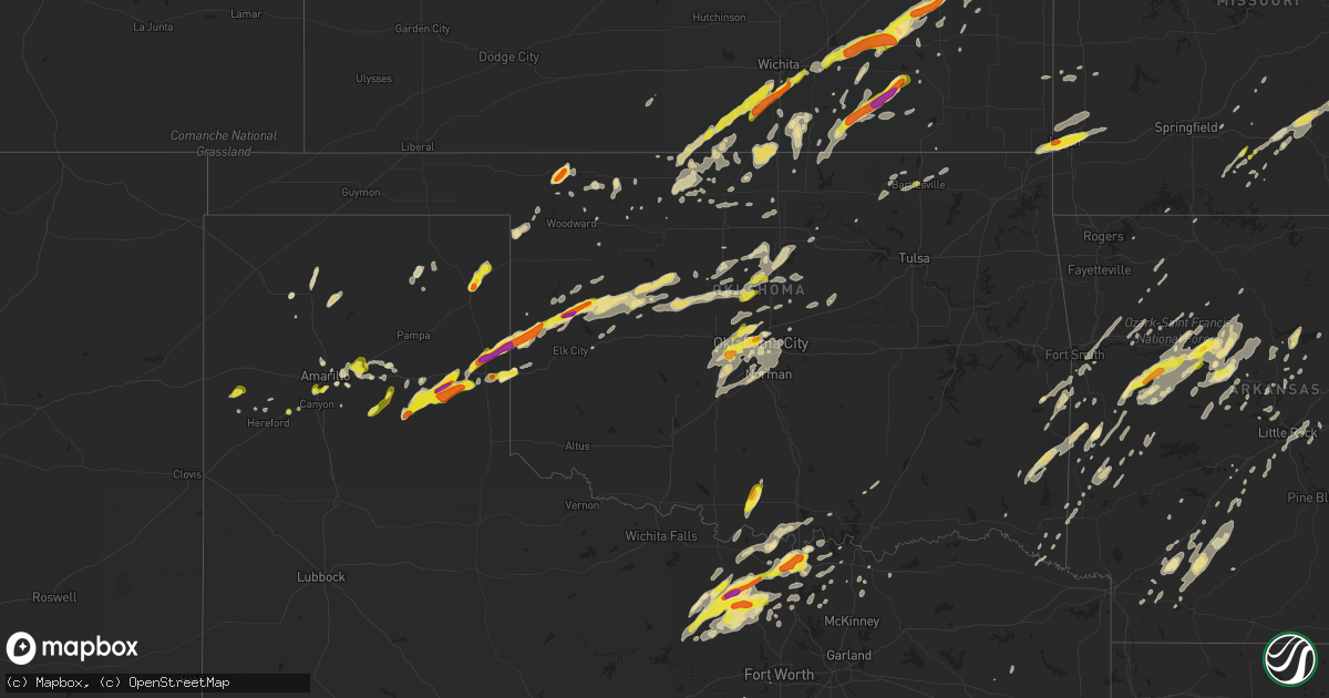
Hail Map in Oklahoma on April 17, 2019
Get this storm
April 17 map
$229
one time, instant access
Download today. No call, no setup
Keep the $229
Bought the map and want the full workflow? Apply the entire $229 to a subscription within 7 days. None of it is wasted.
Every map, not just this one
This buys you this map. Subscription and you get every map we run, in the markets you choose from a few cities to whole states to nationwide. Plus real-time alerts the moment a storm fires.
Contact data
Name, contact info, occupancy, even credit band for addresses in the footprint. You go from where it hit to who to call.
Become the source they trust
Unlimited branding weather history reports on demand. You already have the documented answer ready for the property owner, and you are the one who showed up with it.
Property data and RoofTrace estimates
Pull up any address you have got, its value and the exact code rules for that jurisdiction, straight from One Click Code. Then RoofTrace estimates the squares, pitch, and roof value, priced the way you price.
Storm reports in Oklahoma
Oklahoma
| Date | Description |
|---|---|
| 04/17/20196:30 PM CDT | Report from twitter. |
| 04/17/20195:55 PM CDT | Relayed by em from nwschat. |
| 04/17/20195:44 PM CDT | A local report indicates 1.75 inch wind near TEXOLA |
| 04/17/20195:40 PM CDT | Time is radar estimate. |
| 04/17/20195:40 PM CDT | A local report indicates 1.25 inch wind near TEXOLA |
| 04/17/20195:11 PM CDT | A local report indicates 1.25 inch wind near 1 E STRONG CITY |
| 04/17/20194:47 PM CDT | Two tornadoes observed on the ground by broadcast media and a co-op observer. |
| 04/17/20194:45 PM CDT | Spotternetwork report |
| 04/17/20194:43 PM CDT | Reports of multiple houses damaged at the intersection of n1710 and e0480. Roof reported half removed for one house. Possible tornado damage. Time is radar estimate. |
| 04/17/20194:13 PM CDT | Pea sized hail measured as well. |
| 04/17/20196:03 AM CDT | At 1103 PM CDT, a severe thunderstorm was located 8 miles west of Gillham, or 9 miles northwest of De Queen, moving northeast at 35 mph. HAZARD...60 mph wind gusts and quarter size hail. SOURCE...Radar indicated. IMPACT...Hail damage to vehicles is expected. Expect wind damage to roofs, siding, and trees. Locations impacted include... Gillham and West Line. |
| 04/17/20195:31 AM CDT | At 1030 PM CDT, a severe thunderstorm was located near Chickasha, moving east at 25 mph. HAZARD...60 mph wind gusts and quarter size hail. SOURCE...Radar indicated. IMPACT...Hail damage to vehicles is expected. Expect wind damage to roofs, siding, and trees. Locations impacted include... Chickasha, Blanchard, Amber, Norge, Middleberg, Tabler and Ninnekah. |
| 04/17/20195:21 AM CDT | At 1021 PM CDT, severe thunderstorms were located along a line extending from 6 miles northeast of Grainola to 5 miles east of Burbank to 6 miles northeast of Blackburn to 2 miles northwest of Jennings, moving northeast at 50 mph. HAZARD...70 mph wind gusts and nickel size hail. SOURCE...Radar indicated. IMPACT...Expect considerable tree damage. Damage is likely to mobile homes, roofs, and outbuildings. Locations in or near the path include... Tulsa... Bartlesville... Sand Springs... Pawhuska... Skiatook... Hominy... Cleveland... Barnsdall... Sperry... Shidler... Wynona... Jennings... Avant... Westport... Osage... Hallett... Blackburn... Terlton... Maramec... Elgin... |
| 04/17/20195:14 AM CDT | At 1013 PM CDT, severe thunderstorms were located along a line extending from 5 miles north of Edmond to 3 miles east of Minco, moving northeast at 20 mph. HAZARD...60 mph wind gusts and quarter size hail. SOURCE...Radar indicated. IMPACT...Hail damage to vehicles is expected. Expect wind damage to roofs, siding, and trees. Locations impacted include... Oklahoma City, western Norman, Edmond, Moore, Midwest City, Del City, Newcastle, Yukon, Bethany, Mustang, Choctaw, Warr Acres, The Village, Tuttle, Spencer, Nichols Hills, Jones, Nicoma Park, Minco and Luther. |
| 04/17/20194:58 AM CDT | At 957 PM CDT, severe thunderstorms were located along a line extending from near Glencoe to 4 miles northwest of Tryon, moving east at 40 mph. HAZARD...60 mph wind gusts and penny size hail. SOURCE...Radar indicated. IMPACT...Expect damage to roofs, siding, and trees. Locations impacted include... Stillwater, Cushing, Perkins, Yale, Carney, Glencoe, Tryon, Ripley, Agra, Quay, Avery, Ingalls and Parkland. |
| 04/17/20194:45 AM CDT | At 944 PM CDT, a severe thunderstorm was located near Queen Wilhelmina State Park, or 11 miles northwest of Mena, moving northeast at 45 mph. HAZARD...Quarter size hail. SOURCE...Radar indicated. IMPACT...Damage to vehicles is expected. Locations impacted include... Booneville... Waldron... Beauchamp... Cardiff... Queen Wilhelmina State Park... Acorn... Union Hill... Black Fork Mountain Wilderness... Winfield... Olio... Hon... Y City... Rich Mountain... Needmore... Boles... Carolan... Parks... Eagleton... Grayson... Blue Ball... |
| 04/17/20194:44 AM CDT | At 943 PM CDT, severe thunderstorms were located along a line extending from near Fillmore to 3 miles north of Silo to near Cartwright, moving northeast at 35 mph. HAZARD...60 mph wind gusts and quarter size hail. SOURCE...Radar indicated. IMPACT...Hail damage to vehicles is expected. Expect wind damage to roofs, siding, and trees. Locations impacted include... Durant, Atoka, Tishomingo, Kingston, Colbert, Caddo, Bokchito, Achille, Wapanucka, Stringtown, Bennington, Silo, Milburn, Tushka, Caney, Kenefic, Kemp, Mead, Armstrong and Hendrix. |
| 04/17/20194:43 AM CDT | At 943 PM CDT, severe thunderstorms were located along a line extending from near Oklahoma City to 6 miles southeast of Cogar, moving northeast at 20 mph. HAZARD...60 mph wind gusts and quarter size hail. SOURCE...Radar indicated. IMPACT...Hail damage to vehicles is expected. Expect wind damage to roofs, siding, and trees. Locations impacted include... Western Oklahoma City, Edmond, El Reno, Yukon, Bethany, Mustang, Warr Acres, The Village, Tuttle, Piedmont, Nichols Hills, Union City, Minco, Pocasset, Woodlawn Park and Richland. |
| 04/17/20194:40 AM CDT | At 940 PM CDT, a severe thunderstorm was located near Lake Kiowa, or near Whitesboro, moving east at 20 mph. HAZARD...60 mph wind gusts and quarter size hail. SOURCE...Radar indicated. IMPACT...Hail damage to vehicles is expected. Expect wind damage to roofs, siding, and trees. Locations impacted include... Sherman, Denison, Whitesboro, Pilot Point, Van Alstyne, Howe, Pottsboro, Collinsville, Gunter, Knollwood, Dorchester, Ray Roberts Park Johnson Branch, Lake Kiowa, Eisenhower State Park, southern Lake Texoma, Southmayd, Tioga, Sadler and Luella. |
| 04/17/20194:31 AM CDT | At 931 PM CDT, severe thunderstorms were located along a line extending from 3 miles north of Braman to 3 miles north of Tonkawa to near Perry, moving east at 50 mph. HAZARD...70 mph wind gusts and quarter size hail. SOURCE...Radar indicated. IMPACT...Hail damage to vehicles is expected. Expect considerable tree damage. Wind damage is also likely to mobile homes, roofs, and outbuildings. Locations impacted include... Ponca City, Blackwell, Perry, Tonkawa, Newkirk, Morrison, Kaw City, Red Rock, Marland, Braman, Kildare, Chilocco, Kaw Lake, Lake Mcmurtry, Hardy, Sooner Lake, Lake Carl Blackwell, Ceres, Blackwell Lake and Peckham. |
| 04/17/20194:21 AM CDT | At 919 PM CDT, severe thunderstorms were located from near Mulhall to Guthrie, moving northeast at 40 to 50 mph. The storm are headed in the direction of Stillwater. HAZARD...60 mph wind gusts and quarter size hail. SOURCE...Radar indicated. IMPACT...Hail damage to vehicles is expected. Expect wind damage to roofs, siding, and trees. Locations impacted include... Stillwater, Guthrie, Perkins, Langston, Glencoe, Ripley, Coyle, Mulhall, Lake Carl Blackwell, Lake Mcmurtry, Ingalls and Seward. |
| 04/17/20194:17 AM CDT | At 916 PM CDT, a severe thunderstorm was located near Big Cedar, or 20 miles west of Mena, moving northeast at 50 mph. HAZARD...Quarter size hail. SOURCE...Radar indicated. IMPACT...Damage to vehicles is expected. Locations impacted include... Beauchamp... Queen Wilhelmina State Park... Mountain Fork... Black Fork... Rich Mountain... Black Fork Mountain Wilderness... |
| 04/17/20193:58 AM CDT | At 857 PM CDT, a severe thunderstorm was located near Marshall, moving northeast at 40 to 50 mph. HAZARD...60 to 65 mph wind gusts and quarter size hail. SOURCE...Radar indicated. IMPACT...Hail damage to vehicles is expected. Expect wind damage to roofs, siding, and trees. Locations impacted include... Perry, Waukomis, Covington, Marshall, Orlando, Douglas, Lovell, Lucien, Bison, Lake Mcmurtry and Hayward. |
| 04/17/20193:46 AM CDT | At 846 PM CDT, a severe thunderstorm was located over Lindsay, or near Gainesville, moving northeast at 30 mph. This thunderstorm has a history of producing large hail. HAZARD...Golf ball size hail and 60 mph wind gusts. SOURCE...Radar indicated. IMPACT...People and animals outdoors will be injured. Expect hail damage to roofs, siding, windows, and vehicles. Expect wind damage to roofs, siding, and trees. Locations impacted include... Gainesville, Whitesboro, Pilot Point, Pottsboro, Collinsville, Muenster, Gunter, Lindsay, Callisburg, Dorchester, Ray Roberts Park Johnson Branch, Lake Kiowa, southwestern Lake Texoma, Southmayd, Tioga, Valley View and Sadler.This includes Interstate 35 between mile markers 482 and 503. |
| 04/17/20193:40 AM CDT | At 840 PM CDT, a severe thunderstorm was located near Kingfisher, moving east at 40 mph. HAZARD...60 to 65 mph wind gusts and quarter size hail. SOURCE...Radar indicated. IMPACT...Hail damage to vehicles is expected. Expect wind damage to roofs, siding, and trees. Locations impacted include... Guthrie, Kingfisher, Crescent, Okarche, Cashion, Dover, Cedar Valley, Cimarron City, Lovell, Navina and Seward. |
| 04/17/20193:24 AM CDT | At 824 PM CDT, a severe thunderstorm was located near Loyal, moving east at 40 mph. HAZARD...Ping pong ball size hail and 60 mph wind gusts. SOURCE...Radar indicated. IMPACT...People and animals outdoors will be injured. Expect hail damage to roofs, siding, windows, and vehicles. Expect wind damage to roofs, siding, and trees. Locations impacted include... Hennessey, Waukomis, Okeene, Dover, Loyal, Bison and Lacey. |
| 04/17/20193:17 AM CDT | At 816 PM CDT, a severe thunderstorm was located 4 miles north of Nash, moving east at 40 mph. HAZARD...60 to 65 mph wind gusts and quarter size hail. SOURCE...Radar indicated. IMPACT...Hail damage to vehicles is expected. Expect wind damage to roofs, siding, and trees. Locations impacted include... Wakita, Nash, Jefferson and northeastern Great Salt Plains Lake. |
| 04/17/20193:04 AM CDT | At 804 PM CDT, a severe thunderstorm was located near Greenfield, moving east at 40 mph. HAZARD...Golf ball size hail and 60 mph wind gusts. SOURCE...Radar indicated. IMPACT...People and animals outdoors will be injured. Expect hail damage to roofs, siding, windows, and vehicles. Expect wind damage to roofs, siding, and trees. Locations impacted include... Kingfisher, Geary, Okarche, Dover and Omega. |
| 04/17/20193:00 AM CDT | At 800 PM CDT, a severe thunderstorm was located 5 miles northwest of Healdton, moving north at 45 mph. HAZARD...Ping pong ball size hail and 60 mph wind gusts. SOURCE...Radar indicated. IMPACT...People and animals outdoors will be injured. Expect hail damage to roofs, siding, windows, and vehicles. Expect wind damage to roofs, siding, and trees. Locations impacted include... Healdton, Wilson, Ringling, Elmore City, Velma, Katie, Foster, Tatums, Loco, Ratliff City, Graham, Pooleville, Hennepin, Cornish, Fox and Pernell. |
| 04/17/20192:42 AM CDT | At 742 PM CDT, severe thunderstorms were located along a line extending from 6 miles northwest of Hitchcock to 3 miles northeast of Weatherford, moving east at 30 mph. HAZARD...60 mph wind gusts and half dollar size hail. SOURCE...Radar indicated. IMPACT...Hail damage to vehicles is expected. Expect wind damage to roofs, siding, and trees. Locations impacted include... Weatherford, Watonga, Okeene, Canton, Longdale, Hitchcock, Greenfield, Loyal, eastern Canton Lake, Eagle City, Fay, Homestead, Southard, Omega and Lacey. |
| 04/17/20192:25 AM CDT | At 724 PM CDT, a cluster of severe thunderstorms was located from south of Jacksboro to Bowie to Nocona, moving northeast at 30 mph. HAZARD...60 mph wind gusts and quarter size hail. SOURCE...Radar indicated. IMPACT...Hail damage to vehicles is expected. Expect wind damage to roofs, siding, and trees. Locations impacted include... Bowie, Jacksboro, Nocona, Alvord, St. Jo, Chico, Sunset, Stoneburg, Newport, Runaway Bay and Lake Bridgeport. |
| 04/17/20192:01 AM CDT | At 701 PM CDT, a severe thunderstorm was located near Waynoka, moving northeast at 30 mph. HAZARD...60 mph wind gusts and nickel size hail. SOURCE...Radar indicated. IMPACT...Expect damage to roofs, siding, and trees. Locations impacted include... Waynoka, Avard and Hopeton. |
| 04/17/20191:56 AM CDT | At 655 PM CDT, severe thunderstorms were located along a line extending from 5 miles northeast of Camargo to 8 miles west of Oakwood to 5 miles south of Putnam to 5 miles northwest of Arapaho, moving northeast at 40 mph. HAZARD...Ping pong ball size hail and 60 mph wind gusts. SOURCE...Radar indicated. IMPACT...People and animals outdoors will be injured. Expect hail damage to roofs, siding, windows, and vehicles. Expect wind damage to roofs, siding, and trees. Locations impacted include... Weatherford, Fairview, Taloga, Thomas, Seiling, Arapaho, Canton, Custer City, Butler, Longdale, Camargo, Oakwood, Putnam, Canton Lake, Foss Reservoir, Orion, Chester, Eagle City, Cestos and Fay. |
| 04/17/20191:14 AM CDT | At 613 PM CDT, a severe thunderstorm was located near Selman, moving north at 5 mph. Other strong to severe storms were located between Selman and Freedom. HAZARD...Ping pong ball size hail and 60 mph wind gusts. SOURCE...Radar indicated. IMPACT...People and animals outdoors will be injured. Expect hail damage to roofs, siding, windows, and vehicles. Expect wind damage to roofs, siding, and trees. Locations impacted include... Buffalo, Selman and Alabaster Caverns State Park. |
| 04/17/20191:12 AM CDT | At 612 PM CDT, a severe thunderstorm was located 4 miles northwest of Sayre, moving northeast at 35 mph. HAZARD...60 mph wind gusts and quarter size hail. SOURCE...Radar indicated. IMPACT...Hail damage to vehicles is expected. Expect wind damage to roofs, siding, and trees. Locations impacted include... Elk City, Sayre, Carter and Berlin. |
| 04/17/20191:08 AM CDT | At 607 PM CDT, severe thunderstorms were located along a line extending from 4 miles northwest of Angora to 8 miles southeast of Leedey to 5 miles west of Foss Reservoir, moving northeast at 30 mph. HAZARD...Golf ball size hail and 60 mph wind gusts. SOURCE...Radar indicated. IMPACT...People and animals outdoors will be injured. Expect hail damage to roofs, siding, windows, and vehicles. Expect wind damage to roofs, siding, and trees. Locations impacted include... Taloga, Seiling, Arapaho, Hammon, Leedey, Custer City, Butler, Camargo, Putnam, Foss Reservoir, Angora, Moorewood, Cestos, Hucmac and Stafford. |
| 04/17/20191:07 AM CDT | At 606 PM CDT, a severe thunderstorm was located 2 miles east of Amorita, moving north at 10 mph. HAZARD...Ping pong ball size hail and 60 mph wind gusts. SOURCE...Radar indicated. IMPACT...People and animals outdoors will be injured. Expect hail damage to roofs, siding, windows, and vehicles. Expect wind damage to roofs, siding, and trees. Locations impacted include... Burlington, Amorita, Byron, Driftwood and Waldron. |
| 04/17/201912:49 AM CDT | At 548 PM CDT, a severe thunderstorm was located near May, moving north at 10 mph. HAZARD...60 mph wind gusts and quarter size hail. SOURCE...Radar indicated. IMPACT...Hail damage to vehicles is expected. Expect wind damage to roofs, siding, and trees. Locations impacted include... May. |
| 04/17/201912:31 AM CDT | At 531 PM CDT, a severe thunderstorm was located near Texola, moving east at 30 mph. HAZARD...Ping pong ball size hail and 60 mph wind gusts. SOURCE...Radar indicated. IMPACT...People and animals outdoors will be injured. Expect hail damage to roofs, siding, windows, and vehicles. Expect wind damage to roofs, siding, and trees. Locations impacted include... Erick, Texola and Delhi. |
| 04/17/201912:27 AM CDT | At 527 PM CDT, a severe thunderstorm was located 5 miles east of Strong City, moving northeast at 25 mph. HAZARD...Golf ball size hail and 60 mph wind gusts. SOURCE...Radar indicated. IMPACT...People and animals outdoors will be injured. Expect hail damage to roofs, siding, windows, and vehicles. Expect wind damage to roofs, siding, and trees. Locations impacted include... Hammon, Leedey, Butler, Strong City, Moorewood, Foss Reservoir and Angora. |
| 04/17/201912:17 AM CDT | At 517 PM CDT, a severe thunderstorm was located near Shamrock, moving east at 25 mph. HAZARD...Ping pong ball size hail. SOURCE...Radar indicated. IMPACT...People and animals outdoors will be injured. Expect damage to roofs, siding, windows, and vehicles. Locations impacted include... Shamrock. |
| 04/16/201911:45 PM CDT | A local report indicates 58 MPH wind near 7 E CENTRAILIA |
| 04/16/201911:43 PM CDT | At 443 PM CDT, a severe thunderstorm was located 5 miles north of Shattuck, moving northeast at 25 mph. HAZARD...Ping pong ball size hail and 60 mph wind gusts. SOURCE...Radar indicated. IMPACT...People and animals outdoors will be injured. Expect hail damage to roofs, siding, windows, and vehicles. Expect wind damage to roofs, siding, and trees. Locations impacted include... Shattuck, Gage, Fargo and Catesby. |
| 04/16/201911:39 PM CDT | At 439 PM CDT, a severe thunderstorm was located 8 miles northeast of Sweetwater, moving northeast at 25 mph. HAZARD...Ping pong ball size hail and 60 mph wind gusts. SOURCE...Radar indicated. IMPACT...People and animals outdoors will be injured. Expect hail damage to roofs, siding, windows, and vehicles. Expect wind damage to roofs, siding, and trees. Locations impacted include... Cheyenne, Reydon, Strong City, Roll and Dempsey. |
| 04/16/201911:24 PM CDT | Three inch tree limbs and several power poles broken. |
| 04/16/201911:15 PM CDT | Tree damage... One of which was a large tree downed in the backyard of a residence. Part of roof off of a barn and a couple smaller sheds. Roof off of barn 3 miles east |
| 04/16/201911:06 PM CDT | At 405 PM CDT, a severe thunderstorm was located near Sweetwater, moving northeast at 35 mph. HAZARD...Golf ball size hail and 60 mph wind gusts. SOURCE...Radar indicated. IMPACT...People and animals outdoors will be injured. Expect hail damage to roofs, siding, windows, and vehicles. Expect wind damage to roofs, siding, and trees. Locations impacted include... Cheyenne, Reydon, Sweetwater, Strong City and Dempsey. |
| 04/16/201911:05 PM CDT | Tree limbs broken |
| 04/16/201911:05 PM CDT | Significant damage to park equipment. Guttering and minor shingle damage reported as well. |
| 04/16/201911:04 PM CDT | Tree 2-3 foot diameter downed. |
| 04/16/201911:01 PM CDT | A local report indicates 1.00 inch wind near BARTLESVILLE |
| 04/16/201910:49 PM CDT | Twitter picture in mesta park in okc. |
| 04/16/201910:47 PM CDT | Strong thunderstorm wind blew down several trees |
| 04/16/201910:45 PM CDT | A local report indicates 1.00 inch wind near OKLAHOMA CITY |
| 04/16/201910:40 PM CDT | Strong thunderstorm wind snapped large tree limbs |
| 04/16/201910:40 PM CDT | Twitter post with picture |
| 04/16/201910:37 PM CDT | Strong thunderstorm wind snapped large tree limbs |
| 04/16/201910:25 PM CDT | At 325 PM CDT, a severe thunderstorm was located 7 miles northeast of Twitty, moving northeast at 30 to 35 mph. HAZARD...Two inch hail and 60 mph wind gusts. SOURCE...Radar indicated. IMPACT...People and animals outdoors will be injured. Expect hail damage to roofs, siding, windows, and vehicles. Expect wind damage to roofs, siding, and trees. Locations impacted include... Reydon, Sweetwater and Dempsey. |
| 04/16/201910:25 PM CDT | A local report indicates 1.00 inch wind near 3 S BETHANY |
| 04/16/201910:22 PM CDT | Some power lines down / tree limbs down. |
| 04/16/201910:15 PM CDT | A local report indicates 1.00 inch wind near MUSTANG |
| 04/16/201910:12 PM CDT | Spotternetwork report |
| 04/16/201910:12 PM CDT | Mping report |
| 04/16/201910:10 PM CDT | A local report indicates 1.00 inch wind near PIEDMONT |
| 04/16/201910:05 PM CDT | A local report indicates 62 MPH wind near 3 ENE PAWNEE |
| 04/16/201910:00 PM CDT | A local report indicates 1.00 inch wind near 1 E YUKON |
| 04/16/201910:00 PM CDT | Mesonet report |
| 04/16/201910:00 PM CDT | Roof lifted off house and set back down. Several trees uprooted. Windows busted out in 2 vehicles. Occurred on east end of town. |
| 04/16/20199:51 PM CDT | A local report indicates 1.00 inch wind near 10 SSW STILLWATER |
| 04/16/20199:40 PM CDT | A local report indicates 59 MPH wind near 7 SSE RED ROCK |
| 04/16/20199:30 PM CDT | A local report indicates 62 MPH wind near 4 SSE BLACKWELL |
| 04/16/20199:26 PM CDT | 65-70 mph gusts estimated |
| 04/16/20199:26 PM CDT | Two semi trucks blown over on i-35. One near braman and another at stateline weigh station. |
| 04/16/20199:20 PM CDT | Semi truck blown over on i-35 near blackwell. |
| 04/16/20199:06 PM CDT | A local report indicates 1.00 inch wind near OCTAVIA |
| 04/16/20199:01 PM CDT | Multiple reports of tree damage in lamont. Tree fell on a car. |
| 04/16/20198:50 PM CDT | Additional reports of tree damage and major roof damages to businesses and homes. Some uprooted trees as well. |
| 04/16/20198:50 PM CDT | Pond creek has also lost power. |
| 04/16/20198:50 PM CDT | Time based off radar estimate. |
| 04/16/20198:00 PM CDT | Golf ball and ping pong size hail reported. |
All States Impacted by Hail Map on April 17, 2019
Cities Impacted by Hail Map on April 17, 2019
- Sanger, TX
- Dublin, TX
- Comanche, TX
- Franklin, TX
- Marquez, TX
- Shattuck, OK
- Melvin, TX
- Canadian, TX
- Union City, TN
- Martin, TN
- Rives, TN
- Cotulla, TX
- Panhandle, TX
- Amarillo, TX
- Fort Worth, TX
- Ranger, TX
- Greenville, IL
- Pocahontas, IL
- Delaware, AR
- Dardanelle, AR
- Russellville, AR
- Claude, TX
- Wellington, KS
- Gainesville, TX
- San Saba, TX
- Richland Springs, TX
- Rochelle, TX
- South Haven, KS
- Braman, OK
- Medford, OK
- Caldwell, KS
- Higgins, TX
- Early, TX
- Brownwood, TX
- Smithville, OK
- Mullin, TX
- Zephyr, TX
- Freer, TX
- Hamilton, KS
- Eureka, KS
- Wheeler, TX
- Shamrock, TX
- Sonora, TX
- Junction, TX
- Hondo, TX
- Bandera, TX
- Union City, OK
- Healdton, OK
- Ringling, OK
- Menard, TX
- Del Rio, TX
- Chico, TX
- Sunset, TX
- Weatherby, MO
- Ottawa, KS
- Garnett, KS
- Westphalia, KS
- Richmond, KS
- Williamsburg, KS
- Rantoul, KS
- Princeton, KS
- Waverly, KS
- Cheyenne, OK
- Sweetwater, OK
- Asherton, TX
- Crockett, TX
- Lovelady, TX
- Geuda Springs, KS
- Damascus, AR
- Bee Branch, AR
- Hamilton, TX
- Evant, TX
- Jacksboro, TX
- Bowie, TX
- Ponca City, OK
- Newkirk, OK
- Hennessey, OK
- Cashion, OK
- Guthrie, OK
- Crescent, OK
- Atkins, AR
- Jerusalem, AR
- London, AR
- Dover, AR
- Hector, AR
- Bladen, NE
- Blue Hill, NE
- Winfield, KS
- Arkansas City, KS
- Oxford, KS
- Saint Jo, TX
- Perrin, TX
- Forestburg, TX
- Decatur, TX
- Bridgeport, TX
- Paradise, TX
- Alvord, TX
- Charlotte, TX
- Jourdanton, TX
- Gerald, MO
- Leslie, MO
- Leon, KS
- Kenton, TN
- Quemado, TX
- Brackettville, TX
- Uvalde, TX
- Batesville, TX
- Sabinal, TX
- Bethel, OK
- Hodgen, OK
- Broken Bow, OK
- Mountain Grove, MO
- Houston, MO
- Cabool, MO
- Duenweg, MO
- Carthage, MO
- Joplin, MO
- Elkhart, TX
- Reydon, OK
- Briscoe, TX
- Brady, TX
- Independence, MO
- Buckner, MO
- Blue Springs, MO
- Nocona, TX
- Hunt, TX
- Mountain Home, TX
- Leakey, TX
- Thomas, OK
- Buffalo, OK
- Madill, OK
- Floresville, TX
- Potosi, WI
- Holy Cross, IA
- Sherrill, IA
- Dyersville, IA
- New Vienna, IA
- Conway Springs, KS
- Fenton, MO
- House Springs, MO
- Eureka, MO
- High Ridge, MO
- Hereford, TX
- Dumas, TX
- Warsaw, MO
- Rose Bud, AR
- Quitman, AR
- Knippa, TX
- D Hanis, TX
- La Pryor, TX
- Oklahoma City, OK
- Muenster, TX
- Clarendon, TX
- Mclean, TX
- Laredo, TX
- Hardin, MO
- Richmond, MO
- Ava, MO
- Texola, OK
- Lawrence, NE
- New Blaine, AR
- Paris, AR
- Subiaco, AR
- Scranton, AR
- Dilley, TX
- Pearsall, TX
- Squires, MO
- Dacoma, OK
- Krum, TX
- Calvert, TX
- Guthrie Center, IA
- Sullivan, MO
- Saint Clair, MO
- Waldron, AR
- Aline, OK
- Carmen, OK
- Ozark, AR
- Idabel, OK
- Voca, TX
- Gorman, TX
- Blanket, TX
- Goldthwaite, TX
- Carbon, TX
- Lometa, TX
- De Leon, TX
- Desdemona, TX
- Stephenville, TX
- Cherokee, OK
- Burlington, OK
- Jet, OK
- Roosevelt, TX
- Lenexa, KS
- Kansas City, MO
- Mission, KS
- Prairie Village, KS
- Shawnee, KS
- Overland Park, KS
- Carterville, MO
- Diamond, MO
- Quapaw, OK
- Galena, KS
- Riverton, KS
- Sarcoxie, MO
- Baxter Springs, KS
- Webb City, MO
- Reeds, MO
- Trumann, AR
- Saint Louis, MO
- Grapeland, TX
- Havana, AR
- Kansas City, KS
- Argonia, KS
- Amorita, OK
- Rocksprings, TX
- Clarksville, AR
- Boles, AR
- Parks, AR
- Mena, AR
- San Jon, NM
- Poteau, OK
- Howe, OK
- Burlington, KS
- Gridley, KS
- Moline, KS
- Howard, KS
- Grenola, KS
- Mansfield, AR
- Booneville, AR
- Avoca, MN
- Malvern, AR
- Perryville, AR
- Masonville, IA
- Winthrop, IA
- Independence, IA
- Saint Joseph, MO
- Rushville, MO
- Lenapah, OK
- Delaware, OK
- Yukon, OK
- Saint James, MN
- Mulberry Grove, IL
- Smithboro, IL
- Waldron, KS
- Gentry, MO
- Haworth, OK
- Gage, OK
- Vanzant, MO
- Drury, MO
- Grandview, MO
- Lees Summit, MO
- Minburn, IA
- Elk Falls, KS
- Cambridge, KS
- Cedar Vale, KS
- Dexter, KS
- Fall River, KS
- Sunray, TX
- Whitesboro, TX
- Comstock, TX
- Mooreland, OK
- Bethany, OK
- Sparkman, AR
- Gurdon, AR
- Hammon, OK
- Miami, TX
- Burneyville, OK
- Marietta, OK
- Perry, OK
- Orlando, OK
- Mulhall, OK
- Stillwater, OK
- Wister, OK
- Leawood, KS
- Meridian, OK
- Mount Ida, AR
- Garland City, AR
- Fay, OK
- Taloga, OK
- Canton, OK
- Hitchcock, OK
- Oakwood, OK
- Leedey, OK
- Putnam, OK
- Custer City, OK
- Butler, OK
- Okeene, OK
- Watonga, OK
- Agency, MO
- Atchison, KS
- De Kalb, MO
- Faucett, MO
- Harper, KS
- Anthony, KS
- Haysville, KS
- Clearwater, KS
- Belle Plaine, KS
- Derby, KS
- Mayfield, KS
- Augusta, KS
- Rose Hill, KS
- Peck, KS
- Mulvane, KS
- Danville, KS
- Milan, KS
- Freeport, KS
- Camden, AR
- Kingfisher, OK
- May, TX
- Gilman, IA
- Manchester, IA
- Maumelle, AR
- North Little Rock, AR
- Groesbeck, TX
- Roseland, NE
- Holstein, NE
- Arkadelphia, AR
- Madison, KS
- Virgil, KS
- Tama, IA
- Laurel, IA
- Montour, IA
- Jewett, TX
- Centerville, TX
- Millstadt, IL
- Vandalia, IL
- Caseyville, IL
- Edwardsville, IL
- Belleville, IL
- Collinsville, IL
- Dupo, IL
- Troy, IL
- Keyesport, IL
- East Carondelet, IL
- O'Fallon, IL
- Fairview Heights, IL
- Marine, IL
- Lebanon, IL
- Highland, IL
- Saint Jacob, IL
- East Saint Louis, IL
- Nash, OK
- Collinsville, TX
- Rayville, MO
- Paola, KS
- Stroud, OK
- Chandler, OK
- Davenport, NE
- Shickley, NE
- Mason, IL
- Big Wells, TX
- Breese, IL
- Aviston, IL
- Cameron, OK
- Hackett, AR
- Heavener, OK
- Pottsville, AR
- Sherman, TX
- Kingsville, TX
- Tipton, MO
- Fortuna, MO
- Sheridan, AR
- Hale, MO
- Carrollton, MO
- Mendon, MO
- Norborne, MO
- Brunswick, MO
- Bogard, MO
- Triplett, MO
- Bosworth, MO
- Normangee, TX
- Hearne, TX
- Canyon, TX
- Tina, MO
- Lawson, MO
- Excelsior Springs, MO
- Orrick, MO
- Perryton, TX
- Magazine, AR
- Wichita, KS
- Watson, IL
- Effingham, IL
- Crystal City, TX
- Moscow, IA
- Groom, TX
- Pottsville, TX
- Polk City, IA
- Madrid, IA
- Woodward, IA
- Slater, IA
- Granger, IA
- Walnut Grove, MN
- Westbrook, MN
- Garden City, MO
- Pampa, TX
- Hattieville, AR
- Mansfield, MO
- Norman, OK
- Bloomfield, NE
- Mooresville, IN
- Thackerville, OK
- Lindsay, TX
- Rosston, AR
- Bluff City, AR
- Chidester, AR
- Savannah, MO
- Alva, OK
- Denton, TX
- Barksdale, TX
- Erick, OK
- Freeman, MO
- Drexel, MO
- Elk City, KS
- Longton, KS
- Thornfield, MO
- Delight, AR
- Peculiar, MO
- Cleveland, MO
- Lamar, AR
- Hagarville, AR
- El Dorado, KS
- Rosalia, KS
- Ramsey, IL
- Vilonia, AR
- Conway, AR
- Blanco, TX
- Houston, AR
- Wellington, TX
- Nelson, NE
- Deweese, NE
- Edgar, NE
- Fairfield, NE
- Maysville, MO
- Columbia, IL
- Fredericksburg, TX
- Harper, TX
- Madelia, MN
- Vernon Center, MN
- Amboy, MN
- Edgemont, AR
- Higden, AR
- Pilot Point, TX
- Sinton, TX
- Arnold, MO
- Saint James, MO
- Cuba, MO
- Rusk, TX
- Leon, OK
- Welcome, MN
- Fairmont, MN
- China Spring, TX
- Sayre, OK
- Elk City, OK
- Tuttle, OK
- Sedan, KS
- Medicine Lodge, KS
- Enid, OK
- Hunter, OK
- Kremlin, OK
- Carrizo Springs, TX
- Hastings, NE
- Trenton, IL
- Pawhuska, OK
- Danville, AR
- Waynoka, OK
- Wasola, MO
- Louisburg, KS
- Buffalo, TX
- Oakwood, TX
- Cedar Creek, TX
- Elgin, TX
- Rising Star, TX
- Gordonville, TX
- Marshall, OK
- Covington, OK
- Pocasset, OK
- Haverhill, IA
- Marshalltown, IA
- Amber, OK
- Mustang, OK
- Edmond, OK
- Minco, OK
- El Reno, OK
- Billings, OK
- Garber, OK
- Greenfield, OK
- Chillicothe, MO
- Gillham, AR
- Lewisville, AR
- Hamel, IL
- Toronto, KS
- Riviera, TX
- Greeley, KS
- Norwood, MO
- Fennimore, WI
- Granite City, IL
- Hartford, IL
- East Alton, IL
- Wakita, OK
- Bluff City, KS
- Manchester, OK
- Prescott, AR
- Saint Peter, MN
- Mankato, MN
- Kasota, MN
- Hope, AR
- Bucyrus, KS
- Fairfax, OK
- Augusta, AR
- Mason, TX
- Fredonia, KS
- Grannis, AR
- Lucien, OK
- Lane, KS
- Osawatomie, KS
- Cotton Plant, AR
- Raymondville, MO
- Licking, MO
- Waldo, AR
- Gardner, KS
- Spring Hill, KS
- Olathe, KS
- Currie, MN
- Ong, NE
- Glenvil, NE
- Butterfield, MN
- Bradleyville, MO
- Seymour, MO
- Kosse, TX
- Greenbrier, AR
- Plainview, AR
- Wilson, OK
- Kingston, AR
- Witter, AR
- Coyle, OK
- Perkins, OK
- Umpire, AR
- Helena, OK
- Tioga, TX
- Rolla, MO
- Edgewood, IL
- Lebanon, MO
- Mabelvale, AR
- Bauxite, AR
- De Queen, AR
- Lohn, TX
- Dundas, MN
- Northfield, MN
- Eureka Springs, AR
- Rogers, AR
- Falmouth, IN
- Sadler, TX
- Volga, IA
- Elkader, IA
- Strawberry Point, IA
- Cambridge City, IN
- Connersville, IN
- Milton, IN
- Hawkins, TX
- Atalissa, IA
- West Liberty, IA
- Stockton, IA
- Cameron, TX
- Mount Judea, AR
- Lerna, IL
- Charleston, IL
- Bartlesville, OK
- Colony, KS
- Latham, KS
- Piedmont, KS
- Roland, AR
- Unionville, MO
- Cincinnati, IA
- Powersville, MO
- Corydon, IA
- Seymour, IA
- Wilton, IA
- Bells, TX
- Clifton, TX
- Geneva, NE
- Belleville, AR
- Newcastle, OK
- Blanchard, OK
- Allerton, IA
- Clio, IA
- Lineville, IA
- Foss, OK
- Bonham, TX
- Tipton, IA
- Maxwell, IA
- Cambridge, IA
- Montrose, IL
- Teutopolis, IL
- Panora, IA
- Linden, IA
- Dawson, IA
- Yale, IA
- Wickes, AR
- Whitewright, TX
- Tom Bean, TX
- Luxemburg, IA
- Belmont, WI
- Earlville, IA
- Greeley, IA
- Platteville, WI
- Searsboro, IA
- Fordland, MO
- Pond Creek, OK
- Brookesmith, TX
- Omega, OK
- Okarche, OK
- Geary, OK
- Enola, AR
- Mount Vernon, AR
- Blairstown, IA
- Luzerne, IA
- Montague, TX
- Lynnville, IA
- Sully, IA
- Fargo, OK
- Pencil Bluff, AR
- Sims, AR
- Glen Rose, TX
- London, TX
- Greenwood, MO
- San Diego, TX
- Parker, KS
- Millington, TN
- Strang, NE
- Carleton, NE
- Bruning, NE
- Lavaca, AR
- Dyer, AR
- Alma, AR
- Mulberry, AR
- Van Buren, AR
- Donaldson, AR
- Emmet, AR
- Hillsboro, IL
- Sorento, IL
- Walshville, IL
- New Douglas, IL
- Panama, IL
- Ardmore, OK
- Pettigrew, AR
- Revere, MN
- Sheldon, MO
- Chester, OK
- Corpus Christi, TX
- Bethalto, IL
- Moro, IL
- Dorsey, IL
- Niangua, MO
- Marshfield, MO
- Alleman, IA
- Dallas Center, IA
- Bouton, IA
- Lamar, MO
- Liberal, MO
- Fort Smith, AR
- Exline, IA
- Moulton, IA
- Dawn, MO
- Braymer, MO
- Greenup, IL
- Jewett, IL
- Sidney, TX
- Orange Grove, TX
- Ayr, NE
- Fayette, IA
- Maynard, IA
- Arlington, IA
- Iola, KS
- Piqua, KS
- Atlanta, KS
- Perry, IA
- Sandia, TX
- Greenwood, AR
- Pottsboro, TX
- Cowgill, MO
- Polo, MO
- Bucyrus, MO
- Pattonsburg, MO
- Alhambra, IL
- Sutton, NE
- Saronville, NE
- Amazonia, MO
- Winnetoon, NE
- Indianapolis, IN
- Martinsville, IN
- Martinsville, IL
- Toledo, IL
- Sigel, IL
- Neoga, IL
- Dewey, OK
- Fowlerton, TX
- Burden, KS
- Thornton, TX
- Worden, IL
- Pelsor, AR
- Scotland, AR
- Knoxville, AR
- Clay Center, NE
- Harvard, NE
- Janesville, IA
- Shell Rock, IA
- Tumbling Shoals, AR
- Heber Springs, AR
- England, AR
- Scott, AR
- Berryville, AR
- Huntsville, AR
- Saint Paul, AR
- Yancey, TX
- Fredonia, TX
- Burlington, TX
- Rosebud, TX
- Wellsville, KS
- Welda, KS
- Trilla, IL
- Adona, AR
- Macomb, MO
- Hartford, AR
- Willisville, AR
- Aubrey, TX
- Morrilton, AR
- Casa, AR
- Tilden, TX
- Catarina, TX
- Jonesboro, AR
- Mount Hope, WI
- Lancaster, WI
- Ponder, TX
- Cleburne, TX
- Rainbow, TX
- Granbury, TX
- Rhodes, IA
- Collins, IA
- Faribault, MN
- Canton, SD
- Agra, OK
- Cushing, OK
- Justin, TX
- Yates Center, KS
- Lampe, MO
- Overbrook, OK
- Falls City, TX
- Independence, KS
- Clinton, OK
- Odem, TX
- Springfield, MN
- Marshall, AR
- Center Ridge, AR
- Clinton, AR
- Cleveland, AR
- Leslie, AR
- Blue Mountain, AR
- Humboldt, KS
- Isabel, KS
- Cedar Hill, MO
- Kalona, IA
- Tonkawa, OK
- Jones, OK
- Amity, AR
- Dieterich, IL
- Robstown, TX
- Lonoke, AR
- Campbell, NE
- Valley View, TX
- Era, TX
- Pawnee, OK
- Ola, AR
- Pacific, MO
- Glen Carbon, IL
- Madison, IL
- Imperial, MO
- Carlyle, IL
- Grovespring, MO
- Elkhart, IA
- Bellevue, TX
- Mercer, MO
- Durant, IA
- Choctaw, OK
- Bluff Dale, TX
- Buckholts, TX
- Thorndale, TX
- Granger, TX
- Taylor, TX
- Rockdale, TX
- Spencer, OK
- Chickasha, OK
- Wheatland, OK
- Graham, OK
- Maple City, KS
- Pella, IA
- Mayflower, AR
- Cove, AR
- Vandervoort, AR
- Van Alstyne, TX
- Dover, OK
- Medina, TX
- Channing, TX
- Waukomis, OK
- Bison, OK
- Traskwood, AR
- Laclede, MO
- Meadville, MO
- Howe, TX
- Western, NE
- Jasper, MO
- Oronogo, MO
- Alba, MO
- Purcell, MO
- Neck City, MO
- Carl Junction, MO
- Holton, KS
- Mutual, OK
- Bigelow, AR
- Brownstown, IL
- Arcadia, KS
- Mulberry, KS
- Arma, KS
- Dalhart, TX
- Chelsea, IA
- Belle Plaine, IA
- Leon, IA
- Garden Grove, IA
- Carney, OK
- Wellston, OK
- Coleman, OK
- Cresson, TX
- Gilmer, TX
- Morgan, TX
- Kopperl, TX
- Palestine, TX
- Hatfield, AR
- Piedmont, OK
- Oden, AR
- Wynne, AR
- Cherry Valley, AR
- Leola, AR
- Atoka, OK
- Milano, TX
- Omaha, AR
- West, TX
- Waco, TX
- Camp Wood, TX
- Cory, IN
- Freedom, OK
- Ozone, AR
- Castroville, TX
- Little Rock, AR
- Brookfield, MO
- Coffeyville, KS
- Le Center, MN
- Cleveland, MN
- Arapaho, OK
- Fontana, KS
- La Cygne, KS
- Valliant, OK
- Tyndall, SD
- Morrison, OK
- State Center, IA
- Melbourne, IA
- Loco, OK
- Adrian, TX
- Andover, KS
- Keytesville, MO


