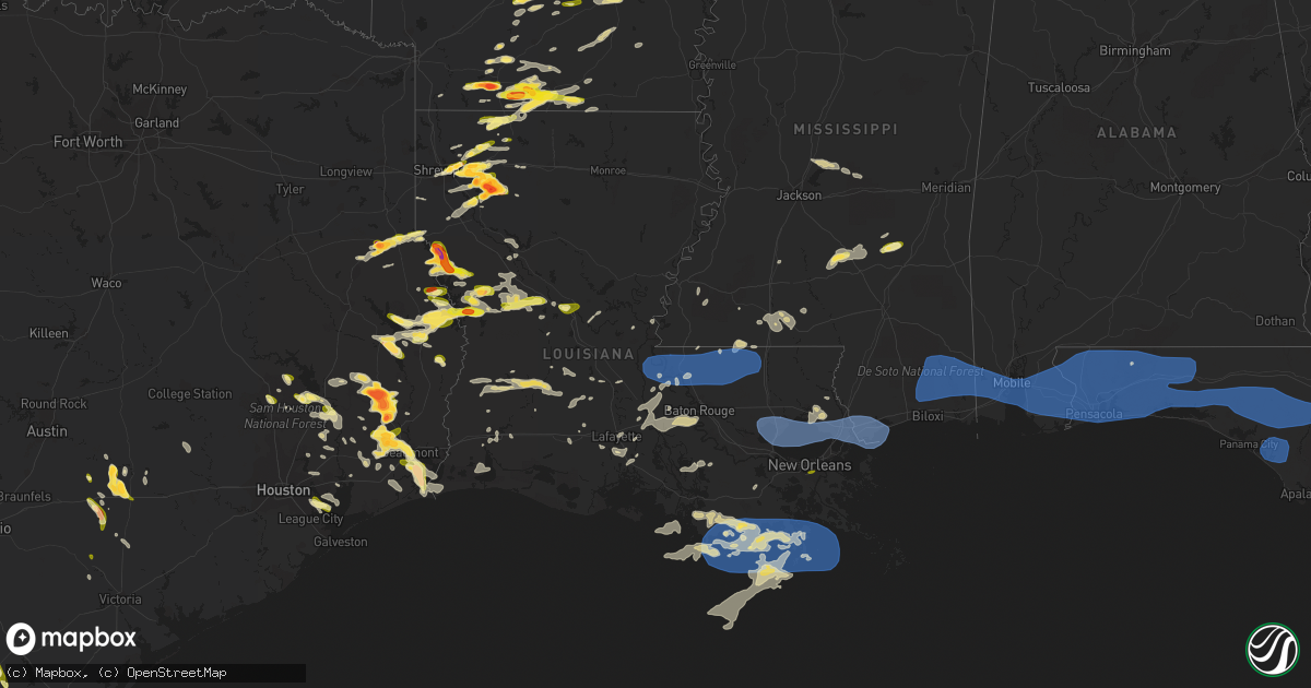
Hail Map in Louisiana on April 15, 2023
Get this storm
April 15 map
$229
one time, instant access
Download today. No call, no setup
Keep the $229
Bought the map and want the full workflow? Apply the entire $229 to a subscription within 7 days. None of it is wasted.
Every map, not just this one
This buys you this map. Subscription and you get every map we run, in the markets you choose from a few cities to whole states to nationwide. Plus real-time alerts the moment a storm fires.
Contact data
Name, contact info, occupancy, even credit band for addresses in the footprint. You go from where it hit to who to call.
Become the source they trust
Unlimited branding weather history reports on demand. You already have the documented answer ready for the property owner, and you are the one who showed up with it.
Property data and RoofTrace estimates
Pull up any address you have got, its value and the exact code rules for that jurisdiction, straight from One Click Code. Then RoofTrace estimates the squares, pitch, and roof value, priced the way you price.
Storm reports in Louisiana
Louisiana
| Date | Description |
|---|---|
| 04/15/20236:51 PM CDT | Report via social media with picture. |
| 04/15/20236:45 PM CDT | A local report indicates 2.00 inch wind near 5 W CONVERSE |
| 04/15/20236:40 PM CDT | Baseball sized. |
| 04/15/20236:20 PM CDT | Report via social media. |
| 04/15/20236:20 PM CDT | A local report indicates 1.75 inch wind near RINGGOLD |
| 04/15/20236:10 PM CDT | Report via social media. |
| 04/15/20235:39 PM CDT | A local report indicates 1.50 inch wind near HAUGHTON |
| 04/15/20235:22 PM CDT | A local report indicates 1.25 inch wind near 1 SE BOSSIER CITY |
| 04/15/20235:09 PM CDT | Lots of quarter size hail. A couple just smaller than ping pong ball size |
| 04/15/20235:00 PM CDT | A local report indicates 1.50 inch wind near BARKSDALE AIR FORCE BAS |
| 04/15/20235:00 PM CDT | A local report indicates 1.50 inch wind near 1 S EASTWOOD |
| 04/15/20231:53 PM CDT | Asos station knew new orleans lakefront airport measured gust o 59 mph or 51 knots. |
| 04/15/20231:40 PM CDT | Trees down over interstate partially blocking lanes. |
| 04/15/20231:30 PM CDT | Corrects previous non-tstm wnd gst report from 7 e east new orleans. Mesonet station 1825w nofd engine 31 - venetian isles. |
| 04/15/20231:25 PM CDT | Hardwood tree approximately 18 inches in diameter fell down on a house. |
| 04/15/20231:18 PM CDT | Trees down along bayou liberty road blocking both lanes. |
| 04/15/20231:14 PM CDT | Corrects previous tstm wnd dmg report from 4 nw slidell. Trees down over interstate partially blocking lanes. |
| 04/15/20231:08 PM CDT | Powerlines down due to trees falling on them near cloverland rd and fish hatchery rd. |
| 04/15/20231:07 PM CDT | Mesonet station xptn pontchartrain causeway measured wind gust of 64 mph or 56 knots. |
| 04/15/202312:00 PM CDT | Tree blown over just east of hwy 445 and hwy 16 intersection. |
| 04/15/202310:00 AM CDT | Large branch snapped. Time estimated off radar. |
| 04/15/20233:12 AM CDT | Buoy station gisl1 grand isle... La. |
| 04/15/20232:55 AM CDT | Awos station kgao galliano. |
| 04/15/20232:21 AM CDT | Dulac measured a sustained wind of 46 mph and a gust of 65 mph. |
| 04/15/20232:14 AM CDT | Hail around the size of quarters reported in algiers. Report via social media and nwschat. |
| 04/15/20232:11 AM CDT | Picture of quarter-sized hail in dularge community of houma shared via social media. |
| 04/14/20239:54 PM CDT | Quarter size hail reported by the rapides parish emergency management direcotr. |
| 04/14/20239:15 PM CDT | Tree |
| 04/14/20239:15 PM CDT | Tree reported down at the corner of five oaks road and highway 550. |
| 04/14/20238:12 PM CDT | Report from local gas station. |
| 04/14/20238:10 PM CDT | Store in sibley reported dime to quarter size hail for several minutes. |
| 04/14/20238:09 PM CDT | Reports of a few trees and powerlines down in town. |
| 04/14/20238:05 PM CDT | Gas station at the corner of 612 and 157 reported nickel to quarter size hail. |
| 04/14/20237:57 PM CDT | Reports of trees down on highway 84 east of clarence. |
| 04/14/20237:33 PM CDT | Reports of powerlines and a few trees down between black lake and campti... La. |
| 04/14/20237:01 PM CDT | A local report indicates 1.75 inch wind near 1 NW RINGGOLD |
| 04/14/20237:00 PM CDT | Report from mping: half dollar |
All States Impacted by Hail Map on April 15, 2023
Cities Impacted by Hail Map on April 15, 2023
- Lewis, IA
- Griswold, IA
- Atlantic, IA
- Syracuse, NE
- Dunbar, NE
- Otoe, NE
- Nebraska City, NE
- Union, NE
- Percival, IA
- Sidney, IA
- Farragut, IA
- Shenandoah, IA
- Imogene, IA
- Essex, IA
- Emerson, IA
- Randolph, IA
- Hastings, IA
- Malvern, IA
- Red Oak, IA
- Bandera, TX
- Pipe Creek, TX
- Boerne, TX
- Comfort, TX
- Macks Creek, MO
- Roach, MO
- Camdenton, MO
- Ventress, LA
- Saint Francisville, LA
- Jackson, LA
- New Roads, LA
- Morganza, LA
- Jarreau, LA
- Slaughter, LA
- Zachary, LA
- Ethel, LA
- Clinton, LA
- Norwood, LA
- Wilson, LA
- Batchelor, LA
- Lettsworth, LA
- Union Bridge, MD
- Westminster, MD
- Pride, LA
- Greenwell Springs, LA
- Greensburg, LA
- Pine Grove, LA
- Denham Springs, LA
- Kentwood, LA
- Amite, LA
- Fluker, LA
- Reisterstown, MD
- Glyndon, MD
- Douglass, KS
- Springfield, LA
- La Place, LA
- Ponchatoula, LA
- Maurepas, LA
- Mount Olive, MS
- Prentiss, MS
- Magee, MS
- Weir, KS
- Pittsburg, KS
- Opolis, KS
- Asbury, MO
- Lacombe, LA
- Soso, MS
- Stringer, MS
- Taylorsville, MS
- Slidell, LA
- Mandeville, LA
- Laurel, MS
- Bay Springs, MS
- New Bloomfield, MO
- Saint Martinville, LA
- New Iberia, LA
- Center Point, LA
- Deville, LA
- New Windsor, MD
- Addis, LA
- Plaquemine, LA
- Grosse Tete, LA
- Port Allen, LA
- Marksville, LA
- Westlake, LA
- Roxie, MS
- Breaux Bridge, LA
- Lake Charles, LA
- Liberty, MS
- Eunice, LA
- Livonia, LA
- Napoleonville, LA
- Golden Meadow, LA
- Lebanon, MO
- Udall, KS
- Osyka, MS
- Fordoche, LA
- Center Valley, PA
- Allentown, PA
- Coopersburg, PA
- Mccomb, MS
- Summit, MS
- Tylertown, MS
- Rosedale, LA
- Maringouin, LA
- Baton Rouge, LA
- Bethlehem, PA
- Dequincy, LA
- Kinder, LA
- Lafayette, LA
- Pierre Part, LA
- Wesson, MS
- Lottie, LA
- Dulac, LA
- Theriot, LA
- Iowa, LA
- Monterey, LA
- Magnolia, MS
- Morgan City, LA
- Port Barre, LA
- Brusly, LA
- Krotz Springs, LA
- Ruth, MS
- Jayess, MS
- Pearl River, LA
- Mindenmines, MO
- Oronogo, MO
- Lamar, MO
- Liberal, MO
- Jasper, MO
- Stockton, MO
- New Orleans, LA
- Bay Saint Louis, MS
- Kiln, MS
- Stennis Space Center, MS
- Pearlington, MS
- Dadeville, MO
- Fair Play, MO
- Waveland, MS
- Pass Christian, MS
- Diamondhead, MS
- Humansville, MO
- Golden City, MO
- Lockwood, MO
- Jerico Springs, MO
- Dunnegan, MO
- South Bound Brook, NJ
- Somerset, NJ
- Piscataway, NJ
- Cairo, IL
- Miller City, IL
- Flemington, MO
- Weaubleau, MO
- Perkinston, MS
- McLain, MS
- Lucedale, MS
- Wiggins, MS
- Vancleave, MS
- Saucier, MS
- Biloxi, MS
- Collins, MO
- Greenfield, MO
- Arcola, MO
- Tamms, IL
- Mounds, IL
- Pulaski, IL
- Ullin, IL
- Bolivar, MO
- Polk, MO
- Wheatland, MO
- Pittsburg, MO
- Hermitage, MO
- Wister, OK
- Shady Point, OK
- Bokoshe, OK
- Urbana, MO
- Aldrich, MO
- Fayetteville, AR
- Farmington, AR
- Springdale, AR
- Bentonville, AR
- Moss Point, MS
- Semmes, AL
- Wilmer, AL
- Theodore, AL
- Eight Mile, AL
- Mobile, AL
- Grand Bay, AL
- Metropolis, IL
- Karnak, IL
- Kevil, KY
- Grand Chain, IL
- Fairhope, AL
- Tunas, MO
- Louisburg, MO
- Muldrow, OK
- Spiro, OK
- Preston, MO
- Fort Smith, AR
- Roland, OK
- Van Buren, AR
- Daphne, AL
- Loxley, AL
- Silverhill, AL
- Foley, AL
- Summerdale, AL
- Half Way, MO
- Buffalo, MO
- Poteau, OK
- Cameron, OK
- Alma, AR
- Robertsdale, AL
- Elberta, AL
- Dyer, AR
- Rogers, AR
- Garfield, AR
- Eldridge, MO
- Windyville, MO
- Mulberry, AR
- Golconda, IL
- Smithland, KY
- Monett, MO
- Verona, MO
- Aurora, MO
- Montreal, MO
- Linn Creek, MO
- Billings, MO
- Republic, MO
- Hackett, AR
- Midland, AR
- Huntington, AR
- Sunrise Beach, MO
- Osage Beach, MO
- Lake Ozark, MO
- Kaiser, MO
- Brumley, MO
- Tuscumbia, MO
- Ozark, AR
- Greenwood, AR
- Mansfield, AR
- Booneville, AR
- Stoutland, MO
- Lamar, AR
- Springfield, MO
- Dover, AR
- Pelsor, AR
- Brookline, MO
- Paris, AR
- Magazine, AR
- Ulman, MO
- Iberia, MO
- Saint Elizabeth, MO
- Richland, MO
- Mount Laurel, NJ
- Elkins, AR
- Hampton, KY
- Burna, KY
- Salem, KY
- Protem, MO
- Marion, KY
- Theodosia, MO
- Rueter, MO
- Reeds Spring, MO
- Walnut Shade, MO
- Branson, MO
- Chestnutridge, MO
- Green Forest, AR
- Dixon, MO
- Meta, MO
- Brinktown, MO
- Hector, AR
- Alpena, AR
- Omaha, AR
- Lead Hill, AR
- Lampe, MO
- Blue Eye, MO
- Strafford, MO
- Bella Vista, AR
- Pea Ridge, AR
- Seligman, MO
- Crocker, MO
- Jerusalem, AR
- Clinton, AR
- Thornfield, MO
- Vienna, MO
- Leslie, AR
- Subiaco, AR
- McDavid, FL
- Century, FL
- Molino, FL
- Seminole, AL
- Bay Minette, AL
- Stapleton, AL
- Jay, FL
- Cantonment, FL
- Lillian, AL
- Pensacola, FL
- Milton, FL
- Gulf Breeze, FL
- Vichy, MO
- Navarre, FL
- Baker, FL
- Wing, AL
- Bagdad, FL
- Mena, AR
- Mary Esther, FL
- Eglin Afb, FL
- Holt, FL
- Laurel Hill, FL
- Crestview, FL
- Florala, AL
- Rolla, MO
- Newburg, MO
- Boles, AR
- Fort Walton Beach, FL
- Hurlburt Field, FL
- Belle, MO
- Cedarcreek, MO
- Kirbyville, MO
- Ava, MO
- Squires, MO
- Bland, MO
- Owensville, MO
- Mount Sterling, MO
- Hermann, MO
- Mountain Grove, MO
- Norwood, MO
- Cabool, MO
- Drury, MO
- Huggins, MO
- Bucyrus, MO
- Macomb, MO
- Rhineland, MO
- Morrison, MO
- Dennard, AR
- Wasola, MO
- New Blaine, AR
- Delaware, AR
- Brixey, MO
- Niceville, FL
- Valparaiso, FL
- Shalimar, FL
- Defuniak Springs, FL
- Shirley, AR
- Cuba, MO
- Rosebud, MO
- Fairfield Bay, AR
- Edgemont, AR
- Success, MO
- Saint James, MO
- Graff, MO
- Dora, MO
- Licking, MO
- Russellville, AR
- London, AR
- Knoxville, AR
- Dardanelle, AR
- Pottsville, AR
- Vanzant, MO
- New Florence, MO
- Beaufort, MO
- Union, MO
- Villa Ridge, MO
- Willow Springs, MO
- West Plains, MO
- Washington, MO
- Beulah, MO
- Edgar Springs, MO
- Isabella, MO
- Shreveport, LA
- Mountain View, AR
- Bossier City, LA
- Barksdale Afb, LA
- Fox, AR
- Leasburg, MO
- Haughton, LA
- Bourbon, MO
- Sullivan, MO
- Princeton, LA
- Arkadelphia, AR
- Gurdon, AR
- Ola, AR
- Casa, AR
- Gerald, MO
- Saint Clair, MO
- Leslie, MO
- Plainview, AR
- Jessieville, AR
- Stamps, AR
- Magnolia, AR
- Taylor, AR
- Sour Lake, TX
- Kountze, TX
- Pleasant Grove, AR
- Mountain View, MO
- Summersville, MO
- Warren, TX
- Scotland, AR
- Pacific, MO
- Gray Summit, MO
- Labadie, MO
- Saint Albans, MO
- Timpson, TX
- Sparkman, AR
- Adona, AR
- Doyline, LA
- Warsaw, IL
- Ursa, IL
- Canton, MO
- Alexandria, MO
- Sutter, IL
- West Point, IL
- Heber Springs, AR
- Carthage, IL
- Basco, IL
- Drasco, AR
- Minden, LA
- Marcella, AR
- Batesville, AR
- Wildwood, MO
- Eureka, MO
- Mount Ida, AR
- Joaquin, TX
- Logansport, LA
- Royal, AR
- Morrilton, AR
- Perry, AR
- Perryville, AR
- Cotton Valley, LA
- Tenaha, TX
- Freeport, FL
- Ponce De Leon, FL
- Vernon, FL
- Chipley, FL
- Ebro, FL
- Youngstown, FL
- Fountain, FL
- Panama City, FL
- Alford, FL
- Altha, FL
- Wewahitchka, FL
- Port Saint Joe, FL
- Mountain Pine, AR
- Elm Grove, LA
- Houston, AR
- Tumbling Shoals, AR
- Wisconsin Rapids, WI
- Ozark, MO
- Osage City, KS
- Monroe Township, NJ
- Monmouth Junction, NJ
- North Brunswick, NJ
- Hampstead, MD
- Hackettstown, NJ
- Stanhope, NJ
- Budd Lake, NJ
- Butler, MO
- Saugerties, NY
- Portland, MO
- Steedman, MO
- Ballwin, MO
- Huntsville, AR
- Saint Joe, AR
- Everton, AR
- Western Grove, AR
- Hightstown, NJ
- Windsor, NJ
- Watertown, WI
- Princeton, NJ
- Kendall Park, NJ
- Cook Sta, MO
- Steelville, MO
- Linn, MO
- Chamois, MO
- Neosho, MO
- Stella, MO
- Hobart, NY
- Robertsville, MO
- Grubville, MO
- Lonedell, MO
- Luebbering, MO
- Hellertown, PA
- Emmaus, PA
- New Haven, MO
- Jonesburg, MO
- High Hill, MO
- Pikesville, MD
- Windsor Mill, MD
- Defiance, MO
- Augusta, MO
- Catawissa, MO
- Chesterfield, MO
- Garrison, TX
- Shongaloo, LA
- Osceola, MO
- Quincy, MO
- Mount Holly, NJ
- Burlington, NJ
- Bainbridge, NY
- Sidney, NY
- Marionville, MO
- Waldo, AR
- Stephens, AR
- McNeil, AR
- Brookport, IL
- Paducah, KY
- Crane, MO
- Clever, MO
- Nixa, MO
- Stockton, NJ
- Lumberville, PA
- New Hope, PA
- Phoenix, MD
- Mize, MS
- Newhebron, MS
- Collins, MS
- Nazareth, PA
- Marlton, NJ
- Voorhees, NJ
- West Berlin, NJ
- Berlin, NJ
- Hainesport, NJ
- Medford, NJ
- Lumberton, NJ
- Wind Gap, PA
- Pen Argyl, PA
- Easton, PA
- Mansfield, MO
- Stark City, MO
- Lutherville Timonium, MD
- Ringoes, NJ
- Thibodaux, LA
- Leon, KS
- Eureka, KS
- Benton, LA
- Mount Vernon, MO
- Pierce City, MO
- Lake Panasoffkee, FL
- Hindsville, AR
- Oxford, NY
- Greene, NY
- Danville, AR
- Eureka Springs, AR
- Upperco, MD
- Alburtis, PA
- Yellville, AR
- Hammonton, NJ
- Belleville, AR
- Altus, AR
- Clarksville, AR
- Rosston, AR
- Forsyth, MO
- Hollister, MO
- Kissee Mills, MO
- Chester, AR
- Bush, LA
- Marshfield, MO
- Bradleyville, MO
- Newton, NJ
- Andover, NJ
- Humboldt, KS
- Everton, MO
- Miller, MO
- Dongola, IL
- Anna, IL
- Prairie Grove, AR
- Mountainburg, AR
- Rudy, AR
- Shell Knob, MO
- Kimberling City, MO
- Willard, MO
- Brooksville, FL
- Rogersville, MO
- Belknap, IL
- Bois D Arc, MO
- Ash Grove, MO
- Montgomery City, MO
- Bushnell, FL
- La Center, KY
- Charleston, MO
- Mound City, IL
- Cypress, IL
- Barlow, KY
- Villa Ridge, IL
- Scott City, MO
- West Paducah, KY
- Benton, MO
- Olmsted, IL
- Vienna, IL
- Charleston, AR
- Butterfield, MO
- Rocky Comfort, MO
- Exeter, MO
- Purdy, MO
- Cassville, MO
- Powell, MO
- Anderson, MO
- Pineville, MO
- Freeburg, MO
- Uniontown, AR
- Plato, MO
- Berryville, AR
- Golden, MO
- Covington, LA
- Abita Springs, LA
- Cockeysville, MD
- Sparks Glencoe, MD
- Washburn, MO
- Olpe, KS
- Witts Springs, AR
- Marshall, AR
- Arkoma, OK
- Fordland, MO
- Winslow, AR
- Caulfield, MO
- Tecumseh, MO
- Centerton, AR
- Hagarville, AR
- Mount Judea, AR
- Cedarville, AR
- Eagle Rock, MO
- Gentry, AR
- Decatur, AR
- Falcon, MO
- Roby, MO
- Noble, MO
- Webster, FL
- West Fork, AR
- Unadilla, NY
- Waldron, AR
- Thebes, IL
- Fredonia, KY
- Hodgen, OK
- Heavener, OK
- Oak Grove, AR
- Long Lane, MO
- Eugene, MO
- Argyle, MO
- Climax Springs, MO
- Branch, AR
- Chidester, AR
- Bradley, AR
- Oark, AR
- Talihina, OK
- Nacogdoches, TX
- Stotts City, MO
- Hartman, AR
- Red Oak, OK
- Pocola, OK
- Bigelow, AR
- Mayflower, AR
- Hot Springs National Park, AR
- Leola, AR
- Carthage, AR
- Plymouth, IL
- Tennessee, IL
- Saint Louis, MO
- Converse, LA
- Shelbyville, TX
- Hot Springs Village, AR
- Maryland Heights, MO
- Blandinsville, IL
- Colchester, IL
- La Harpe, IL
- Valley Park, MO
- Fenton, MO
- Ringgold, LA
- Heflin, LA
- El Dorado, AR
- Paron, AR
- Little Rock, AR
- Roland, AR
- Conway, AR
- Hazelwood, MO
- Saint Ann, MO
- Bridgeton, MO
- Florissant, MO
- Earth City, MO
- Lumberton, TX
- Floral, AR
- Pleasant Plains, AR
- Silsbee, TX
- Junction City, AR
- Jamestown, LA
- Lonsdale, AR
- North Little Rock, AR
- Beaumont, TX
- Richwoods, MO
- Dittmer, MO
- Hillsboro, MO
- Festus, MO
- De Soto, MO
- Crystal City, MO
- Marianna, FL
- Clarksville, FL
- Pevely, MO
- Herculaneum, MO
- Waterloo, IL
- Valmeyer, IL
- Barnhart, MO
- Woodville, TX
- Fred, TX
- Benton, AR
- Bryant, AR
- East Saint Louis, IL
- Granite City, IL
- Venice, IL
- Madison, IL
- Lovejoy, IL
- Alexander, AR
- New Athens, IL
- Prattsville, AR
- Vilonia, AR
- Cabot, AR
- Austin, AR
- Ward, AR
- Scott, AR
- Dupo, IL
- Columbia, IL
- Millstadt, IL
- East Carondelet, IL
- Belleville, IL
- O'Fallon, IL
- Collinsville, IL
- Fairview Heights, IL
- Caseyville, IL
- Edwardsville, IL
- Sulphur Rock, AR
- Baylis, IL
- Perry, IL
- Griggsville, IL
- Chambersburg, IL
- Charlotte, AR
- Glen Carbon, IL
- Maryville, IL
- Troy, IL
- Newark, AR
- Magness, AR
- Cord, AR
- Newport, AR
- Tuckerman, AR
- Versailles, IL
- Meredosia, IL
- Arenzville, IL
- Beardstown, IL
- Swifton, AR
- Cash, AR
- Chapin, IL
- Virginia, IL
- Fisher, AR
- Weiner, AR
- Jonesboro, AR
- Amagon, AR
- Chandlerville, IL
- Bath, IL
- Lonoke, AR
- Beebe, AR
- Tallula, IL
- Ashland, IL
- Mansfield, LA
- Jacksonville, AR
- Oakford, IL
- Petersburg, IL
- Kilbourne, IL
- Harrisburg, AR
- Noble, LA
- Zwolle, LA
- Lebanon, IL
- Saint Jacob, IL
- Carlisle, AR
- Freeburg, IL
- Scott Air Force Base, IL
- Mascoutah, IL
- Emerson, AR
- Ivan, AR
- Fordyce, AR
- Kingsland, AR
- New Baden, IL
- Trenton, IL
- Summerfield, IL
- Bay, AR
- Marine, IL
- Highland, IL
- Walnut Ridge, AR
- England, AR
- Many, LA
- Blountstown, FL
- Bristol, FL
- Hosford, FL
- West Point, TX
- Pocahontas, IL
- Alhambra, IL
- Muldoon, TX
- La Grange, TX
- Rosanky, TX
- Waelder, TX
- Flatonia, TX
- Germantown, IL
- Aviston, IL
- Albers, IL
- Hazen, AR
- Des Arc, AR
- Biscoe, AR
- Hickory Plains, AR
- De Valls Bluff, AR
- Searcy, AR
- Griffithville, AR
- Augusta, AR
- McCrory, AR
- Schulenburg, TX
- Cotton Plant, AR
- Nashville, IL
- Oakdale, IL
- Addieville, IL
- Marked Tree, AR
- Trumann, AR
- Okawville, IL
- Caraway, AR
- Lake City, AR
- Lepanto, AR
- Hoyleton, IL
- Easton, IL
- Athens, IL
- Greenview, IL
- Sibley, LA
- Florien, LA
- Osceola, AR
- Etowah, AR
- Brinkley, AR
- Wheatley, AR
- Hunter, AR
- Palestine, AR
- Colt, AR
- Wynne, AR
- Goodwin, AR
- Du Bois, IL
- Ashley, IL
- Scheller, IL
- Tamaroa, IL
- Bonnie, IL
- Woodlawn, IL
- Waltonville, IL
- Mount Vernon, IL
- Peoria, IL
- Edwards, IL
- Dunlap, IL
- Canton, IL
- Farmington, IL
- Yates City, IL
- Elmwood, IL
- Trivoli, IL
- Hanna City, IL
- Brimfield, IL
- Glasford, IL
- Mapleton, IL
- Fairview, IL
- Norris, IL
- Maquon, IL
- London Mills, IL
- Abingdon, IL
- Saint Augustine, IL
- Berwick, IL
- East Galesburg, IL
- Williamsfield, IL
- Gilson, IL
- Roseville, IL
- Ellisville, IL
- Cameron, IL
- Avon, IL
- Galesburg, IL
- Knoxville, IL
- Dahinda, IL
- Laura, IL
- Victoria, IL
- Moro, AR
- Forrest City, AR
- Belle Rive, IL
- Bluford, IL
- Opdyke, IL
- Ina, IL
- Strong, AR
- Pleasanton, TX
- Jourdanton, TX
- Campbellton, TX
- Haynesville, LA
- Vidor, TX
- Widener, AR
- Madison, AR
- Buncombe, IL
- Heth, AR
- Makanda, IL
- Proctor, AR
- Parkin, AR
- Earle, AR
- Edmondson, AR
- Marion, AR
- Crawfordsville, AR
- Goreville, IL
- Homer, LA
- Carbondale, IL
- Marion, IL
- Port Arthur, TX
- Nederland, TX
- Port Neches, TX
- Rison, AR
- Whitsett, TX
- West Memphis, AR
- Groves, TX
- Star City, AR
- Grady, AR
- Gould, AR
- Stuttgart, AR
- Altheimer, AR
- Gillett, AR
- Tichnor, AR
- Alexandria, LA
- Boyce, LA
- Pineville, LA
- Freistatt, MO
- La Porte, TX
- Pasadena, TX
- Baytown, TX
- Seabrook, TX
- Calliham, TX
- Three Rivers, TX
- George West, TX
- Hopedale, IL
- Tremont, IL
- Flemington, NJ
- Nekoosa, WI
- East Brunswick, NJ
- Bangor, PA
- Red Bud, IL
- Littleton, IL
- Camden, IL
- Rushville, IL
- Hecker, IL
- Wickliffe, KY
- Fletcher, MO
- West Alton, MO
- Bowling Green, MO
- Middletown, MO
- Metamora, IL
- Black, MO
- Morton, IL
- Cedar Hill, MO
- Pittsburg, IL
- Johnston City, IL
- Clayton, IL
- Liberty, IL
- Plainville, IL
- Warsaw, VA
- Montross, VA
- Grand Cane, LA
- Quitman, AR
- Ida, AR
- Wilburn, AR
- Concord, AR
- Pangburn, AR
- Manito, IL
- Bellflower, MO
- Briggsville, AR
- Rover, AR
- Hartville, MO
- Monticello, MO
- Parkton, MD
- Bienville, LA
- Saratoga, TX
- Cranbury, NJ
- Princeton Junction, NJ
- Havana, IL
- Lewistown, IL
- Ipava, IL
- Pekin, IL
- Groveland, IL
- Ozark, IL
- New Burnside, IL
- Mineral Point, MO
- Bonne Terre, MO
- Sparta, IL
- Coulterville, IL
- Tilden, IL
- Marissa, IL
- Wentzville, MO
- Cherryville, MO
- Warren, AR
- Hampton, AR
- Banks, AR
- Seymour, MO
- Camden, AR
- Galena, MO
- Louisiana, MO
- Pine Bluff, AR
- Marquand, MO
- Patton, MO
- Saint Charles, MO
- Poplar Bluff, MO
- Jackson, MO
- Altenburg, MO
- Oak Ridge, MO
- West Frankfort, IL
- Orient, IL
- Story, AR
- Sheridan, AR
- Macomb, IL
- Bee Branch, AR
- De Witt, AR
- Maumelle, AR
- Perryville, MO
- Saint Mary, MO
- Altoona, FL
- Higden, AR
- Cleveland, AR
- Locust Grove, AR
- Prim, AR
- Dayton, TX
- Bath, PA
- Corning, AR
- Timewell, IL
- Fort McCoy, FL
- Cobden, IL
- Marthasville, MO
- Thompsonville, IL
- Carrier Mills, IL
- Gorham, IL
- Cameron, LA
- Sabine Pass, TX
- San Augustine, TX
- Elmer, LA
- Glenmora, LA
- Natchitoches, LA
- Arcadia, LA
- Jasper, TX
- Colmesneil, TX
- Smithville, TX
- Cleveland, TX
- Sparta, MO
- Sicklerville, NJ
- Bauxite, AR
- Simpson, IL
- New Waverly, TX
- Willis, TX
- Malvern, AR
- Leopold, MO
- Marble Hill, MO
- Whitewater, MO
- Burfordville, MO
- Otis, LA
- Gonzales, TX
- Olive Branch, IL
- Grantsburg, IL
- Sikeston, MO
- Armstrong, TX
- Potosi, MO
- Dubberly, LA
- Campbell Hill, IL
- Jacob, IL
- Cutler, IL
- Pinckneyville, IL
- Ava, IL
- Rockwood, IL
- Sherwood, AR
- Fayetteville, TX
- Weimar, TX
- Sebring, FL
- Coushatta, LA
- Livingston, TX
- Gibsland, LA
- Athens, LA
- Bronson, TX
- Milam, TX
- Hemphill, TX
- Amity, AR
- Naylor, MO
- Shiner, TX
- Hallettsville, TX
- Fifty Six, AR
- Millersville, MO
- Bearden, AR
- Rosie, AR
- Polk City, FL
- Lakeland, FL
- Shepherd, TX
- Coldspring, TX
- Liberty, TX
- Anacoco, LA
- Hornbeck, LA
- Pineland, TX
- Wiergate, TX
- Astor, FL
- El Paso, AR
- Frohna, MO
- Center, TX
- Center Ridge, AR
- Brenham, TX
- Chappell Hill, TX
- Keithville, LA
- Oakhurst, TX
- Robeline, LA
- Flatwoods, LA
- Leesville, LA
- Lena, LA
- Broaddus, TX
- Brookeland, TX
- Natchez, LA
- Mora, LA
- Zavalla, TX
- Cloutierville, LA
- Provencal, LA
- Newton, TX
- Smackover, AR
- Yorktown, AR
- Mount Holly, AR
- Louann, AR
- Carterville, IL
- Devers, TX
- Saint Peters, MO
- High Ridge, MO
- Houston, MO
- Wolf Lake, IL
- Pomona, IL
- Alto Pass, IL
- Judsonia, AR
- Campti, LA
- Traskwood, AR
- Mabelvale, AR
- Okolona, AR
- Lady Lake, FL
- Marion, LA
- Nome, TX
- Spurger, TX
- Hillister, TX
- China, TX
- Eminence, MO
- Moulton, TX
- McRae, AR
- Huntsville, TX
- Weirsdale, FL
- Winnie, TX
- Buna, TX
- Mackinaw, IL
- Benton, KY
- Palatka, FL
- Orange Grove, TX
- Houma, LA
- Gibson, LA
- Montegut, LA
- Chauvin, LA
- Bourg, LA
- Lockport, LA
- Cut Off, LA
- Galliano, LA
- Stonefort, IL
- Creal Springs, IL
- Davisville, MO
- Canton, MS
- Oberlin, LA
- Longville, LA
- Mittie, LA
- Singer, LA
- Dry Creek, LA
- Deridder, LA
- Mamou, LA
- Smithdale, MS
- Huttig, AR
- Cuero, TX
- Oakdale, LA
- Ville Platte, LA
- Hamshire, TX
- Crowley, LA
- Crumrod, AR
- Mellwood, AR
- Brandon, MS
- Lena, MS
- Rayne, LA
- Clarksdale, MS
- Salem, MO
- Vidalia, LA
- Saint Bernard, LA
- Hull, TX
- Wheaton, MO
- Saint Charles, AR
- Crosby, TX
- Okeechobee, FL
- Church Point, LA
- Belle Rose, LA
- Plattenville, LA
- Wallisville, TX
- Youngsville, LA
- Broussard, LA
- Sulphur, LA
- Monticello, AR
- Huffman, TX
- Maurice, LA
- Duson, LA
- Morse, LA
- Estherwood, LA
- Pearl, MS
- Deer Park, TX
- Alice, TX
- Hackberry, LA
- Washington, IL
- Forest, MS
- Morton, MS
- Donaldson, AR
- Palmetto, LA
- Washington, LA
- Roma, TX
- Grand Isle, LA
- Port Sulphur, LA
- Lafitte, LA
- Niangua, MO
- Conway, MO
- Grovespring, MO
- Lynchburg, MO
- Pointblank, TX
- Gretna, LA
- Harvey, LA


