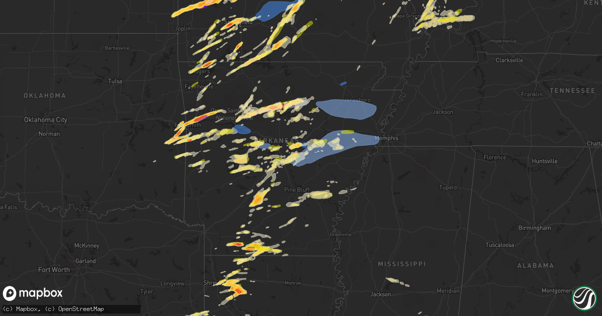
Hail Map in Arkansas on April 15, 2023
Get this storm
April 15 map
$229
one time, instant access
Download today. No call, no setup
Keep the $229
Bought the map and want the full workflow? Apply the entire $229 to a subscription within 7 days. None of it is wasted.
Every map, not just this one
This buys you this map. Subscription and you get every map we run, in the markets you choose from a few cities to whole states to nationwide. Plus real-time alerts the moment a storm fires.
Contact data
Name, contact info, occupancy, even credit band for addresses in the footprint. You go from where it hit to who to call.
Become the source they trust
Unlimited branding weather history reports on demand. You already have the documented answer ready for the property owner, and you are the one who showed up with it.
Property data and RoofTrace estimates
Pull up any address you have got, its value and the exact code rules for that jurisdiction, straight from One Click Code. Then RoofTrace estimates the squares, pitch, and roof value, priced the way you price.
Storm reports in Arkansas
Arkansas
| Date | Description |
|---|---|
| 04/15/20236:59 PM CDT | A local report indicates 1.00 inch wind near 1 ESE SPRINGHILL |
| 04/15/20236:53 PM CDT | A local report indicates 1.00 inch wind near 2 N SPRINGHILL |
| 04/15/20236:53 PM CDT | A local report indicates 1.00 inch wind near 1 SSE HOLLY SPRINGS |
| 04/15/20236:53 PM CDT | A local report indicates 1.00 inch wind near 1 NE BRYANT |
| 04/15/20236:52 PM CDT | A local report indicates 66 MPH wind near NEWPORT REGIONAL AIRPOR |
| 04/15/20236:52 PM CDT | Trees and powerlines down in swifton. Gusts estimated 60-70 mph. |
| 04/15/20236:40 PM CDT | 2 mi east of hopewell rd. |
| 04/15/20236:35 PM CDT | A local report indicates 1.00 inch wind near SOUTHSIDE |
| 04/15/20236:32 PM CDT | A local report indicates 1.00 inch wind near 1 E PRATTSVILLE |
| 04/15/20236:30 PM CDT | A local report indicates 1.00 inch wind near 3 NE FOUNTAIN LAKE |
| 04/15/20236:12 PM CDT | A local report indicates 1.00 inch wind near 4 WSW MOUNTAIN VALLEY |
| 04/15/20236:10 PM CDT | A local report indicates 1.25 inch wind near LONO |
| 04/15/20236:07 PM CDT | Social media post showing trees and powerlines down over a road in addition to a tree on a shed. |
| 04/15/20235:50 PM CDT | A local report indicates 1.00 inch wind near 2 S AVANT |
| 04/15/20235:40 PM CDT | Picture of large hailstone on social media... No measurement reference in the photo. |
| 04/15/20235:23 PM CDT | A local report indicates 1.50 inch wind near MAGNOLIA |
| 04/15/20235:20 PM CDT | Damage to outbuildings east of jerusalem. |
| 04/15/20235:20 PM CDT | A local report indicates 1.75 inch wind near SHIRLEY |
| 04/15/20235:16 PM CDT | A local report indicates 1.00 inch wind near 2 W FOX |
| 04/15/20235:15 PM CDT | Social media picture of a hailstone estimated at baseball size a little southwest of magnolia. |
| 04/15/20235:10 PM CDT | A local report indicates 1.25 inch wind near 7 N MCNEIL |
| 04/15/20235:06 PM CDT | A local report indicates 1.75 inch wind near 8 SW MAGNOLIA |
| 04/15/20235:05 PM CDT | Corrects previous tstm wnd dmg report from 3 ne russellville regional airport. Large trees blown down... Roots pulled from ground. |
| 04/15/20235:01 PM CDT | A local report indicates 60 MPH wind near RUSSELLVILLE REGIONAL A |
| 04/15/20234:55 PM CDT | A local report indicates 2.50 inch wind near 1 N BOTKINBURG |
| 04/15/20234:55 PM CDT | A local report indicates 1.75 inch wind near 1 SSE BOTKINBURG |
| 04/15/20234:38 PM CDT | Report via mping. |
| 04/15/20234:30 PM CDT | A local report indicates 1.00 inch wind near 2 SW FLIPPIN |
| 04/15/20234:29 PM CDT | Social media report... Estimated pea to quarter size hail in woodland... Ar. |
| 04/15/20234:16 PM CDT | Report via mping. |
| 04/15/20233:58 PM CDT | A local report indicates 1.00 inch wind near 1 SSW CHISMVILLE |
| 04/15/20233:51 PM CDT | Report of tree limb damage. |
| 04/15/20233:50 PM CDT | A local report indicates 1.00 inch wind near 3 S CAULKSVILLE |
| 04/15/20233:44 PM CDT | Report relayed by emergency manager. |
| 04/15/20233:40 PM CDT | Hail observed near 2257 mt. Harmondy raod southeast of greenwood. Relayed by amateur radio. |
| 04/15/20233:38 PM CDT | A local report indicates 1.00 inch wind near 1 NNW ELKINS |
| 04/15/20233:37 PM CDT | A local report indicates 1.75 inch wind near WITCHERVILLE |
| 04/15/20233:30 PM CDT | A local report indicates 1.00 inch wind near MULBERRY |
| 04/15/20233:30 PM CDT | Relayed by storm chaser. |
| 04/15/20233:30 PM CDT | Storm spotter reported 1.75 inch hail 9 miles northwest of hector... Ar. |
| 04/15/20233:29 PM CDT | A local report indicates 2.50 inch wind near MULBERRY |
| 04/15/20233:29 PM CDT | Social media report. |
| 04/15/20233:26 PM CDT | A local report indicates 2.00 inch wind near 1 S GARFIELD |
| 04/15/20233:21 PM CDT | Broken tree limbs and some shingles blown off roof. |
| 04/15/20233:12 PM CDT | Relayed by broadcast media. |
| 04/15/20233:10 PM CDT | A local report indicates 2.50 inch wind near ALMA |
| 04/15/20233:09 PM CDT | A local report indicates 1.25 inch wind near 4 NW PEA RIDGE |
| 04/15/20233:06 PM CDT | A local report indicates 1.75 inch wind near 1 NNE FORT SMITH |
| 04/15/20233:04 PM CDT | Social media report with picture. |
| 04/15/20233:02 PM CDT | A local report indicates 1.25 inch wind near 1 E BENTONVILLE |
| 04/15/20232:57 PM CDT | A local report indicates 1.50 inch wind near 3 WSW VAN BUREN |
| 04/15/20232:56 PM CDT | A local report indicates 1.00 inch wind near 3 SE CENTERTON |
| 04/15/20232:55 PM CDT | Thunderstorm winds estimated to 60 mph. |
| 04/15/20232:55 PM CDT | A local report indicates 2.00 inch wind near 1 WSW FORT SMITH |
| 04/15/20232:55 PM CDT | A local report indicates 1.00 inch wind near 1 E VAN BUREN |
| 04/15/20232:55 PM CDT | A local report indicates 1.00 inch wind near CENTERTON |
| 04/15/20232:54 PM CDT | Large trees down with damage to a horse shed. |
| 04/15/20232:50 PM CDT | A local report indicates 1.00 inch wind near 2 WSW VAN BUREN |
| 04/15/20232:47 PM CDT | Tree limbs up to one inch in diameter broken. |
| 04/15/20232:41 PM CDT | A local report indicates 1.00 inch wind near 2 ESE WHEELER |
| 04/15/20232:39 PM CDT | A local report indicates 1.00 inch wind near 2 WSW JOHNSON |
| 04/15/20232:37 PM CDT | A local report indicates 1.00 inch wind near 2 N FARMINGTON |
| 04/14/20238:30 PM CDT | Estimated report from employee at teddy bears truckstop in strong. |
| 04/14/20238:08 PM CDT | Tree on car on wise ln. |
| 04/14/20238:05 PM CDT | Tree down on power poles in manila. |
| 04/14/20238:00 PM CDT | Public report of lots of dime to quarter size hail falling south of el dorado. |
| 04/14/20237:43 PM CDT | Picture of hail in corning. |
| 04/14/20237:40 PM CDT | Power lines down along highway 135 at county road 992. |
| 04/14/20237:35 PM CDT | Corrects previous non-tstm wnd gst report from 3 s mccreanor. Personal weather station measured 61 mph. |
| 04/14/20237:33 PM CDT | Carport blown over. |
| 04/14/20237:20 PM CDT | Trees down in walnut ridge. |
| 04/14/20237:12 PM CDT | A local report indicates 1.00 inch wind near 1 WNW SOUTH BEND |
| 04/14/20237:12 PM CDT | A local report indicates 1.50 inch wind near 2 NNW AUSTIN |
| 04/14/20237:10 PM CDT | A local report indicates 1.00 inch wind near 1 ENE WARD |
| 04/14/20237:07 PM CDT | Tractor trailer blown over on highway 67... Northbound lane. |
| 04/14/20237:03 PM CDT | A local report indicates 1.00 inch wind near 1 SW HILLCREST |
| 04/14/20237:02 PM CDT | A local report indicates 1.00 inch wind near 1 SSW AUSTIN |
All States Impacted by Hail Map on April 15, 2023
Cities Impacted by Hail Map on April 15, 2023
- Lewis, IA
- Griswold, IA
- Atlantic, IA
- Syracuse, NE
- Dunbar, NE
- Otoe, NE
- Nebraska City, NE
- Union, NE
- Percival, IA
- Sidney, IA
- Farragut, IA
- Shenandoah, IA
- Imogene, IA
- Essex, IA
- Emerson, IA
- Randolph, IA
- Hastings, IA
- Malvern, IA
- Red Oak, IA
- Bandera, TX
- Pipe Creek, TX
- Boerne, TX
- Comfort, TX
- Macks Creek, MO
- Roach, MO
- Camdenton, MO
- Ventress, LA
- Saint Francisville, LA
- Jackson, LA
- New Roads, LA
- Morganza, LA
- Jarreau, LA
- Slaughter, LA
- Zachary, LA
- Ethel, LA
- Clinton, LA
- Norwood, LA
- Wilson, LA
- Batchelor, LA
- Lettsworth, LA
- Union Bridge, MD
- Westminster, MD
- Pride, LA
- Greenwell Springs, LA
- Greensburg, LA
- Pine Grove, LA
- Denham Springs, LA
- Kentwood, LA
- Amite, LA
- Fluker, LA
- Reisterstown, MD
- Glyndon, MD
- Douglass, KS
- Springfield, LA
- La Place, LA
- Ponchatoula, LA
- Maurepas, LA
- Mount Olive, MS
- Prentiss, MS
- Magee, MS
- Weir, KS
- Pittsburg, KS
- Opolis, KS
- Asbury, MO
- Lacombe, LA
- Soso, MS
- Stringer, MS
- Taylorsville, MS
- Slidell, LA
- Mandeville, LA
- Laurel, MS
- Bay Springs, MS
- New Bloomfield, MO
- Saint Martinville, LA
- New Iberia, LA
- Center Point, LA
- Deville, LA
- New Windsor, MD
- Addis, LA
- Plaquemine, LA
- Grosse Tete, LA
- Port Allen, LA
- Marksville, LA
- Westlake, LA
- Roxie, MS
- Breaux Bridge, LA
- Lake Charles, LA
- Liberty, MS
- Eunice, LA
- Livonia, LA
- Napoleonville, LA
- Golden Meadow, LA
- Lebanon, MO
- Udall, KS
- Osyka, MS
- Fordoche, LA
- Center Valley, PA
- Allentown, PA
- Coopersburg, PA
- Mccomb, MS
- Summit, MS
- Tylertown, MS
- Rosedale, LA
- Maringouin, LA
- Baton Rouge, LA
- Bethlehem, PA
- Dequincy, LA
- Kinder, LA
- Lafayette, LA
- Pierre Part, LA
- Wesson, MS
- Lottie, LA
- Dulac, LA
- Theriot, LA
- Iowa, LA
- Monterey, LA
- Magnolia, MS
- Morgan City, LA
- Port Barre, LA
- Brusly, LA
- Krotz Springs, LA
- Ruth, MS
- Jayess, MS
- Pearl River, LA
- Mindenmines, MO
- Oronogo, MO
- Lamar, MO
- Liberal, MO
- Jasper, MO
- Stockton, MO
- New Orleans, LA
- Bay Saint Louis, MS
- Kiln, MS
- Stennis Space Center, MS
- Pearlington, MS
- Dadeville, MO
- Fair Play, MO
- Waveland, MS
- Pass Christian, MS
- Diamondhead, MS
- Humansville, MO
- Golden City, MO
- Lockwood, MO
- Jerico Springs, MO
- Dunnegan, MO
- South Bound Brook, NJ
- Somerset, NJ
- Piscataway, NJ
- Cairo, IL
- Miller City, IL
- Flemington, MO
- Weaubleau, MO
- Perkinston, MS
- McLain, MS
- Lucedale, MS
- Wiggins, MS
- Vancleave, MS
- Saucier, MS
- Biloxi, MS
- Collins, MO
- Greenfield, MO
- Arcola, MO
- Tamms, IL
- Mounds, IL
- Pulaski, IL
- Ullin, IL
- Bolivar, MO
- Polk, MO
- Wheatland, MO
- Pittsburg, MO
- Hermitage, MO
- Wister, OK
- Shady Point, OK
- Bokoshe, OK
- Urbana, MO
- Aldrich, MO
- Fayetteville, AR
- Farmington, AR
- Springdale, AR
- Bentonville, AR
- Moss Point, MS
- Semmes, AL
- Wilmer, AL
- Theodore, AL
- Eight Mile, AL
- Mobile, AL
- Grand Bay, AL
- Metropolis, IL
- Karnak, IL
- Kevil, KY
- Grand Chain, IL
- Fairhope, AL
- Tunas, MO
- Louisburg, MO
- Muldrow, OK
- Spiro, OK
- Preston, MO
- Fort Smith, AR
- Roland, OK
- Van Buren, AR
- Daphne, AL
- Loxley, AL
- Silverhill, AL
- Foley, AL
- Summerdale, AL
- Half Way, MO
- Buffalo, MO
- Poteau, OK
- Cameron, OK
- Alma, AR
- Robertsdale, AL
- Elberta, AL
- Dyer, AR
- Rogers, AR
- Garfield, AR
- Eldridge, MO
- Windyville, MO
- Mulberry, AR
- Golconda, IL
- Smithland, KY
- Monett, MO
- Verona, MO
- Aurora, MO
- Montreal, MO
- Linn Creek, MO
- Billings, MO
- Republic, MO
- Hackett, AR
- Midland, AR
- Huntington, AR
- Sunrise Beach, MO
- Osage Beach, MO
- Lake Ozark, MO
- Kaiser, MO
- Brumley, MO
- Tuscumbia, MO
- Ozark, AR
- Greenwood, AR
- Mansfield, AR
- Booneville, AR
- Stoutland, MO
- Lamar, AR
- Springfield, MO
- Dover, AR
- Pelsor, AR
- Brookline, MO
- Paris, AR
- Magazine, AR
- Ulman, MO
- Iberia, MO
- Saint Elizabeth, MO
- Richland, MO
- Mount Laurel, NJ
- Elkins, AR
- Hampton, KY
- Burna, KY
- Salem, KY
- Protem, MO
- Marion, KY
- Theodosia, MO
- Rueter, MO
- Reeds Spring, MO
- Walnut Shade, MO
- Branson, MO
- Chestnutridge, MO
- Green Forest, AR
- Dixon, MO
- Meta, MO
- Brinktown, MO
- Hector, AR
- Alpena, AR
- Omaha, AR
- Lead Hill, AR
- Lampe, MO
- Blue Eye, MO
- Strafford, MO
- Bella Vista, AR
- Pea Ridge, AR
- Seligman, MO
- Crocker, MO
- Jerusalem, AR
- Clinton, AR
- Thornfield, MO
- Vienna, MO
- Leslie, AR
- Subiaco, AR
- McDavid, FL
- Century, FL
- Molino, FL
- Seminole, AL
- Bay Minette, AL
- Stapleton, AL
- Jay, FL
- Cantonment, FL
- Lillian, AL
- Pensacola, FL
- Milton, FL
- Gulf Breeze, FL
- Vichy, MO
- Navarre, FL
- Baker, FL
- Wing, AL
- Bagdad, FL
- Mena, AR
- Mary Esther, FL
- Eglin Afb, FL
- Holt, FL
- Laurel Hill, FL
- Crestview, FL
- Florala, AL
- Rolla, MO
- Newburg, MO
- Boles, AR
- Fort Walton Beach, FL
- Hurlburt Field, FL
- Belle, MO
- Cedarcreek, MO
- Kirbyville, MO
- Ava, MO
- Squires, MO
- Bland, MO
- Owensville, MO
- Mount Sterling, MO
- Hermann, MO
- Mountain Grove, MO
- Norwood, MO
- Cabool, MO
- Drury, MO
- Huggins, MO
- Bucyrus, MO
- Macomb, MO
- Rhineland, MO
- Morrison, MO
- Dennard, AR
- Wasola, MO
- New Blaine, AR
- Delaware, AR
- Brixey, MO
- Niceville, FL
- Valparaiso, FL
- Shalimar, FL
- Defuniak Springs, FL
- Shirley, AR
- Cuba, MO
- Rosebud, MO
- Fairfield Bay, AR
- Edgemont, AR
- Success, MO
- Saint James, MO
- Graff, MO
- Dora, MO
- Licking, MO
- Russellville, AR
- London, AR
- Knoxville, AR
- Dardanelle, AR
- Pottsville, AR
- Vanzant, MO
- New Florence, MO
- Beaufort, MO
- Union, MO
- Villa Ridge, MO
- Willow Springs, MO
- West Plains, MO
- Washington, MO
- Beulah, MO
- Edgar Springs, MO
- Isabella, MO
- Shreveport, LA
- Mountain View, AR
- Bossier City, LA
- Barksdale Afb, LA
- Fox, AR
- Leasburg, MO
- Haughton, LA
- Bourbon, MO
- Sullivan, MO
- Princeton, LA
- Arkadelphia, AR
- Gurdon, AR
- Ola, AR
- Casa, AR
- Gerald, MO
- Saint Clair, MO
- Leslie, MO
- Plainview, AR
- Jessieville, AR
- Stamps, AR
- Magnolia, AR
- Taylor, AR
- Sour Lake, TX
- Kountze, TX
- Pleasant Grove, AR
- Mountain View, MO
- Summersville, MO
- Warren, TX
- Scotland, AR
- Pacific, MO
- Gray Summit, MO
- Labadie, MO
- Saint Albans, MO
- Timpson, TX
- Sparkman, AR
- Adona, AR
- Doyline, LA
- Warsaw, IL
- Ursa, IL
- Canton, MO
- Alexandria, MO
- Sutter, IL
- West Point, IL
- Heber Springs, AR
- Carthage, IL
- Basco, IL
- Drasco, AR
- Minden, LA
- Marcella, AR
- Batesville, AR
- Wildwood, MO
- Eureka, MO
- Mount Ida, AR
- Joaquin, TX
- Logansport, LA
- Royal, AR
- Morrilton, AR
- Perry, AR
- Perryville, AR
- Cotton Valley, LA
- Tenaha, TX
- Freeport, FL
- Ponce De Leon, FL
- Vernon, FL
- Chipley, FL
- Ebro, FL
- Youngstown, FL
- Fountain, FL
- Panama City, FL
- Alford, FL
- Altha, FL
- Wewahitchka, FL
- Port Saint Joe, FL
- Mountain Pine, AR
- Elm Grove, LA
- Houston, AR
- Tumbling Shoals, AR
- Wisconsin Rapids, WI
- Ozark, MO
- Osage City, KS
- Monroe Township, NJ
- Monmouth Junction, NJ
- North Brunswick, NJ
- Hampstead, MD
- Hackettstown, NJ
- Stanhope, NJ
- Budd Lake, NJ
- Butler, MO
- Saugerties, NY
- Portland, MO
- Steedman, MO
- Ballwin, MO
- Huntsville, AR
- Saint Joe, AR
- Everton, AR
- Western Grove, AR
- Hightstown, NJ
- Windsor, NJ
- Watertown, WI
- Princeton, NJ
- Kendall Park, NJ
- Cook Sta, MO
- Steelville, MO
- Linn, MO
- Chamois, MO
- Neosho, MO
- Stella, MO
- Hobart, NY
- Robertsville, MO
- Grubville, MO
- Lonedell, MO
- Luebbering, MO
- Hellertown, PA
- Emmaus, PA
- New Haven, MO
- Jonesburg, MO
- High Hill, MO
- Pikesville, MD
- Windsor Mill, MD
- Defiance, MO
- Augusta, MO
- Catawissa, MO
- Chesterfield, MO
- Garrison, TX
- Shongaloo, LA
- Osceola, MO
- Quincy, MO
- Mount Holly, NJ
- Burlington, NJ
- Bainbridge, NY
- Sidney, NY
- Marionville, MO
- Waldo, AR
- Stephens, AR
- McNeil, AR
- Brookport, IL
- Paducah, KY
- Crane, MO
- Clever, MO
- Nixa, MO
- Stockton, NJ
- Lumberville, PA
- New Hope, PA
- Phoenix, MD
- Mize, MS
- Newhebron, MS
- Collins, MS
- Nazareth, PA
- Marlton, NJ
- Voorhees, NJ
- West Berlin, NJ
- Berlin, NJ
- Hainesport, NJ
- Medford, NJ
- Lumberton, NJ
- Wind Gap, PA
- Pen Argyl, PA
- Easton, PA
- Mansfield, MO
- Stark City, MO
- Lutherville Timonium, MD
- Ringoes, NJ
- Thibodaux, LA
- Leon, KS
- Eureka, KS
- Benton, LA
- Mount Vernon, MO
- Pierce City, MO
- Lake Panasoffkee, FL
- Hindsville, AR
- Oxford, NY
- Greene, NY
- Danville, AR
- Eureka Springs, AR
- Upperco, MD
- Alburtis, PA
- Yellville, AR
- Hammonton, NJ
- Belleville, AR
- Altus, AR
- Clarksville, AR
- Rosston, AR
- Forsyth, MO
- Hollister, MO
- Kissee Mills, MO
- Chester, AR
- Bush, LA
- Marshfield, MO
- Bradleyville, MO
- Newton, NJ
- Andover, NJ
- Humboldt, KS
- Everton, MO
- Miller, MO
- Dongola, IL
- Anna, IL
- Prairie Grove, AR
- Mountainburg, AR
- Rudy, AR
- Shell Knob, MO
- Kimberling City, MO
- Willard, MO
- Brooksville, FL
- Rogersville, MO
- Belknap, IL
- Bois D Arc, MO
- Ash Grove, MO
- Montgomery City, MO
- Bushnell, FL
- La Center, KY
- Charleston, MO
- Mound City, IL
- Cypress, IL
- Barlow, KY
- Villa Ridge, IL
- Scott City, MO
- West Paducah, KY
- Benton, MO
- Olmsted, IL
- Vienna, IL
- Charleston, AR
- Butterfield, MO
- Rocky Comfort, MO
- Exeter, MO
- Purdy, MO
- Cassville, MO
- Powell, MO
- Anderson, MO
- Pineville, MO
- Freeburg, MO
- Uniontown, AR
- Plato, MO
- Berryville, AR
- Golden, MO
- Covington, LA
- Abita Springs, LA
- Cockeysville, MD
- Sparks Glencoe, MD
- Washburn, MO
- Olpe, KS
- Witts Springs, AR
- Marshall, AR
- Arkoma, OK
- Fordland, MO
- Winslow, AR
- Caulfield, MO
- Tecumseh, MO
- Centerton, AR
- Hagarville, AR
- Mount Judea, AR
- Cedarville, AR
- Eagle Rock, MO
- Gentry, AR
- Decatur, AR
- Falcon, MO
- Roby, MO
- Noble, MO
- Webster, FL
- West Fork, AR
- Unadilla, NY
- Waldron, AR
- Thebes, IL
- Fredonia, KY
- Hodgen, OK
- Heavener, OK
- Oak Grove, AR
- Long Lane, MO
- Eugene, MO
- Argyle, MO
- Climax Springs, MO
- Branch, AR
- Chidester, AR
- Bradley, AR
- Oark, AR
- Talihina, OK
- Nacogdoches, TX
- Stotts City, MO
- Hartman, AR
- Red Oak, OK
- Pocola, OK
- Bigelow, AR
- Mayflower, AR
- Hot Springs National Park, AR
- Leola, AR
- Carthage, AR
- Plymouth, IL
- Tennessee, IL
- Saint Louis, MO
- Converse, LA
- Shelbyville, TX
- Hot Springs Village, AR
- Maryland Heights, MO
- Blandinsville, IL
- Colchester, IL
- La Harpe, IL
- Valley Park, MO
- Fenton, MO
- Ringgold, LA
- Heflin, LA
- El Dorado, AR
- Paron, AR
- Little Rock, AR
- Roland, AR
- Conway, AR
- Hazelwood, MO
- Saint Ann, MO
- Bridgeton, MO
- Florissant, MO
- Earth City, MO
- Lumberton, TX
- Floral, AR
- Pleasant Plains, AR
- Silsbee, TX
- Junction City, AR
- Jamestown, LA
- Lonsdale, AR
- North Little Rock, AR
- Beaumont, TX
- Richwoods, MO
- Dittmer, MO
- Hillsboro, MO
- Festus, MO
- De Soto, MO
- Crystal City, MO
- Marianna, FL
- Clarksville, FL
- Pevely, MO
- Herculaneum, MO
- Waterloo, IL
- Valmeyer, IL
- Barnhart, MO
- Woodville, TX
- Fred, TX
- Benton, AR
- Bryant, AR
- East Saint Louis, IL
- Granite City, IL
- Venice, IL
- Madison, IL
- Lovejoy, IL
- Alexander, AR
- New Athens, IL
- Prattsville, AR
- Vilonia, AR
- Cabot, AR
- Austin, AR
- Ward, AR
- Scott, AR
- Dupo, IL
- Columbia, IL
- Millstadt, IL
- East Carondelet, IL
- Belleville, IL
- O'Fallon, IL
- Collinsville, IL
- Fairview Heights, IL
- Caseyville, IL
- Edwardsville, IL
- Sulphur Rock, AR
- Baylis, IL
- Perry, IL
- Griggsville, IL
- Chambersburg, IL
- Charlotte, AR
- Glen Carbon, IL
- Maryville, IL
- Troy, IL
- Newark, AR
- Magness, AR
- Cord, AR
- Newport, AR
- Tuckerman, AR
- Versailles, IL
- Meredosia, IL
- Arenzville, IL
- Beardstown, IL
- Swifton, AR
- Cash, AR
- Chapin, IL
- Virginia, IL
- Fisher, AR
- Weiner, AR
- Jonesboro, AR
- Amagon, AR
- Chandlerville, IL
- Bath, IL
- Lonoke, AR
- Beebe, AR
- Tallula, IL
- Ashland, IL
- Mansfield, LA
- Jacksonville, AR
- Oakford, IL
- Petersburg, IL
- Kilbourne, IL
- Harrisburg, AR
- Noble, LA
- Zwolle, LA
- Lebanon, IL
- Saint Jacob, IL
- Carlisle, AR
- Freeburg, IL
- Scott Air Force Base, IL
- Mascoutah, IL
- Emerson, AR
- Ivan, AR
- Fordyce, AR
- Kingsland, AR
- New Baden, IL
- Trenton, IL
- Summerfield, IL
- Bay, AR
- Marine, IL
- Highland, IL
- Walnut Ridge, AR
- England, AR
- Many, LA
- Blountstown, FL
- Bristol, FL
- Hosford, FL
- West Point, TX
- Pocahontas, IL
- Alhambra, IL
- Muldoon, TX
- La Grange, TX
- Rosanky, TX
- Waelder, TX
- Flatonia, TX
- Germantown, IL
- Aviston, IL
- Albers, IL
- Hazen, AR
- Des Arc, AR
- Biscoe, AR
- Hickory Plains, AR
- De Valls Bluff, AR
- Searcy, AR
- Griffithville, AR
- Augusta, AR
- McCrory, AR
- Schulenburg, TX
- Cotton Plant, AR
- Nashville, IL
- Oakdale, IL
- Addieville, IL
- Marked Tree, AR
- Trumann, AR
- Okawville, IL
- Caraway, AR
- Lake City, AR
- Lepanto, AR
- Hoyleton, IL
- Easton, IL
- Athens, IL
- Greenview, IL
- Sibley, LA
- Florien, LA
- Osceola, AR
- Etowah, AR
- Brinkley, AR
- Wheatley, AR
- Hunter, AR
- Palestine, AR
- Colt, AR
- Wynne, AR
- Goodwin, AR
- Du Bois, IL
- Ashley, IL
- Scheller, IL
- Tamaroa, IL
- Bonnie, IL
- Woodlawn, IL
- Waltonville, IL
- Mount Vernon, IL
- Peoria, IL
- Edwards, IL
- Dunlap, IL
- Canton, IL
- Farmington, IL
- Yates City, IL
- Elmwood, IL
- Trivoli, IL
- Hanna City, IL
- Brimfield, IL
- Glasford, IL
- Mapleton, IL
- Fairview, IL
- Norris, IL
- Maquon, IL
- London Mills, IL
- Abingdon, IL
- Saint Augustine, IL
- Berwick, IL
- East Galesburg, IL
- Williamsfield, IL
- Gilson, IL
- Roseville, IL
- Ellisville, IL
- Cameron, IL
- Avon, IL
- Galesburg, IL
- Knoxville, IL
- Dahinda, IL
- Laura, IL
- Victoria, IL
- Moro, AR
- Forrest City, AR
- Belle Rive, IL
- Bluford, IL
- Opdyke, IL
- Ina, IL
- Strong, AR
- Pleasanton, TX
- Jourdanton, TX
- Campbellton, TX
- Haynesville, LA
- Vidor, TX
- Widener, AR
- Madison, AR
- Buncombe, IL
- Heth, AR
- Makanda, IL
- Proctor, AR
- Parkin, AR
- Earle, AR
- Edmondson, AR
- Marion, AR
- Crawfordsville, AR
- Goreville, IL
- Homer, LA
- Carbondale, IL
- Marion, IL
- Port Arthur, TX
- Nederland, TX
- Port Neches, TX
- Rison, AR
- Whitsett, TX
- West Memphis, AR
- Groves, TX
- Star City, AR
- Grady, AR
- Gould, AR
- Stuttgart, AR
- Altheimer, AR
- Gillett, AR
- Tichnor, AR
- Alexandria, LA
- Boyce, LA
- Pineville, LA
- Freistatt, MO
- La Porte, TX
- Pasadena, TX
- Baytown, TX
- Seabrook, TX
- Calliham, TX
- Three Rivers, TX
- George West, TX
- Hopedale, IL
- Tremont, IL
- Flemington, NJ
- Nekoosa, WI
- East Brunswick, NJ
- Bangor, PA
- Red Bud, IL
- Littleton, IL
- Camden, IL
- Rushville, IL
- Hecker, IL
- Wickliffe, KY
- Fletcher, MO
- West Alton, MO
- Bowling Green, MO
- Middletown, MO
- Metamora, IL
- Black, MO
- Morton, IL
- Cedar Hill, MO
- Pittsburg, IL
- Johnston City, IL
- Clayton, IL
- Liberty, IL
- Plainville, IL
- Warsaw, VA
- Montross, VA
- Grand Cane, LA
- Quitman, AR
- Ida, AR
- Wilburn, AR
- Concord, AR
- Pangburn, AR
- Manito, IL
- Bellflower, MO
- Briggsville, AR
- Rover, AR
- Hartville, MO
- Monticello, MO
- Parkton, MD
- Bienville, LA
- Saratoga, TX
- Cranbury, NJ
- Princeton Junction, NJ
- Havana, IL
- Lewistown, IL
- Ipava, IL
- Pekin, IL
- Groveland, IL
- Ozark, IL
- New Burnside, IL
- Mineral Point, MO
- Bonne Terre, MO
- Sparta, IL
- Coulterville, IL
- Tilden, IL
- Marissa, IL
- Wentzville, MO
- Cherryville, MO
- Warren, AR
- Hampton, AR
- Banks, AR
- Seymour, MO
- Camden, AR
- Galena, MO
- Louisiana, MO
- Pine Bluff, AR
- Marquand, MO
- Patton, MO
- Saint Charles, MO
- Poplar Bluff, MO
- Jackson, MO
- Altenburg, MO
- Oak Ridge, MO
- West Frankfort, IL
- Orient, IL
- Story, AR
- Sheridan, AR
- Macomb, IL
- Bee Branch, AR
- De Witt, AR
- Maumelle, AR
- Perryville, MO
- Saint Mary, MO
- Altoona, FL
- Higden, AR
- Cleveland, AR
- Locust Grove, AR
- Prim, AR
- Dayton, TX
- Bath, PA
- Corning, AR
- Timewell, IL
- Fort McCoy, FL
- Cobden, IL
- Marthasville, MO
- Thompsonville, IL
- Carrier Mills, IL
- Gorham, IL
- Cameron, LA
- Sabine Pass, TX
- San Augustine, TX
- Elmer, LA
- Glenmora, LA
- Natchitoches, LA
- Arcadia, LA
- Jasper, TX
- Colmesneil, TX
- Smithville, TX
- Cleveland, TX
- Sparta, MO
- Sicklerville, NJ
- Bauxite, AR
- Simpson, IL
- New Waverly, TX
- Willis, TX
- Malvern, AR
- Leopold, MO
- Marble Hill, MO
- Whitewater, MO
- Burfordville, MO
- Otis, LA
- Gonzales, TX
- Olive Branch, IL
- Grantsburg, IL
- Sikeston, MO
- Armstrong, TX
- Potosi, MO
- Dubberly, LA
- Campbell Hill, IL
- Jacob, IL
- Cutler, IL
- Pinckneyville, IL
- Ava, IL
- Rockwood, IL
- Sherwood, AR
- Fayetteville, TX
- Weimar, TX
- Sebring, FL
- Coushatta, LA
- Livingston, TX
- Gibsland, LA
- Athens, LA
- Bronson, TX
- Milam, TX
- Hemphill, TX
- Amity, AR
- Naylor, MO
- Shiner, TX
- Hallettsville, TX
- Fifty Six, AR
- Millersville, MO
- Bearden, AR
- Rosie, AR
- Polk City, FL
- Lakeland, FL
- Shepherd, TX
- Coldspring, TX
- Liberty, TX
- Anacoco, LA
- Hornbeck, LA
- Pineland, TX
- Wiergate, TX
- Astor, FL
- El Paso, AR
- Frohna, MO
- Center, TX
- Center Ridge, AR
- Brenham, TX
- Chappell Hill, TX
- Keithville, LA
- Oakhurst, TX
- Robeline, LA
- Flatwoods, LA
- Leesville, LA
- Lena, LA
- Broaddus, TX
- Brookeland, TX
- Natchez, LA
- Mora, LA
- Zavalla, TX
- Cloutierville, LA
- Provencal, LA
- Newton, TX
- Smackover, AR
- Yorktown, AR
- Mount Holly, AR
- Louann, AR
- Carterville, IL
- Devers, TX
- Saint Peters, MO
- High Ridge, MO
- Houston, MO
- Wolf Lake, IL
- Pomona, IL
- Alto Pass, IL
- Judsonia, AR
- Campti, LA
- Traskwood, AR
- Mabelvale, AR
- Okolona, AR
- Lady Lake, FL
- Marion, LA
- Nome, TX
- Spurger, TX
- Hillister, TX
- China, TX
- Eminence, MO
- Moulton, TX
- McRae, AR
- Huntsville, TX
- Weirsdale, FL
- Winnie, TX
- Buna, TX
- Mackinaw, IL
- Benton, KY
- Palatka, FL
- Orange Grove, TX
- Houma, LA
- Gibson, LA
- Montegut, LA
- Chauvin, LA
- Bourg, LA
- Lockport, LA
- Cut Off, LA
- Galliano, LA
- Stonefort, IL
- Creal Springs, IL
- Davisville, MO
- Canton, MS
- Oberlin, LA
- Longville, LA
- Mittie, LA
- Singer, LA
- Dry Creek, LA
- Deridder, LA
- Mamou, LA
- Smithdale, MS
- Huttig, AR
- Cuero, TX
- Oakdale, LA
- Ville Platte, LA
- Hamshire, TX
- Crowley, LA
- Crumrod, AR
- Mellwood, AR
- Brandon, MS
- Lena, MS
- Rayne, LA
- Clarksdale, MS
- Salem, MO
- Vidalia, LA
- Saint Bernard, LA
- Hull, TX
- Wheaton, MO
- Saint Charles, AR
- Crosby, TX
- Okeechobee, FL
- Church Point, LA
- Belle Rose, LA
- Plattenville, LA
- Wallisville, TX
- Youngsville, LA
- Broussard, LA
- Sulphur, LA
- Monticello, AR
- Huffman, TX
- Maurice, LA
- Duson, LA
- Morse, LA
- Estherwood, LA
- Pearl, MS
- Deer Park, TX
- Alice, TX
- Hackberry, LA
- Washington, IL
- Forest, MS
- Morton, MS
- Donaldson, AR
- Palmetto, LA
- Washington, LA
- Roma, TX
- Grand Isle, LA
- Port Sulphur, LA
- Lafitte, LA
- Niangua, MO
- Conway, MO
- Grovespring, MO
- Lynchburg, MO
- Pointblank, TX
- Gretna, LA
- Harvey, LA


