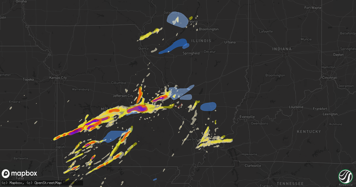
Hail Map on April 15, 2023
Get this storm
April 15 map
$229
one time, instant access
Download today. No call, no setup
Keep the $229
Bought the map and want the full workflow? Apply the entire $229 to a subscription within 7 days. None of it is wasted.
Every map, not just this one
This buys you this map. Subscription and you get every map we run, in the markets you choose from a few cities to whole states to nationwide. Plus real-time alerts the moment a storm fires.
Contact data
Name, contact info, occupancy, even credit band for addresses in the footprint. You go from where it hit to who to call.
Become the source they trust
Unlimited branding weather history reports on demand. You already have the documented answer ready for the property owner, and you are the one who showed up with it.
Property data and RoofTrace estimates
Pull up any address you have got, its value and the exact code rules for that jurisdiction, straight from One Click Code. Then RoofTrace estimates the squares, pitch, and roof value, priced the way you price.
States Impacted by Hail Map on April 15, 2023
Storm reports
Florida
| Date | Description |
|---|---|
| 04/15/20236:56 PM CDT | Numerous trees down across jackson county. |
| 04/15/20236:50 PM CDT | Tree down on county road 379a. |
| 04/15/20236:30 PM CDT | Numerous trees down across jackson county. |
| 04/15/20236:30 PM CDT | Numerous trees down across calhoun county. |
| 04/15/20236:24 PM CDT | Numerous trees down across calhoun county. |
| 04/15/20236:21 PM CDT | Numerous trees down across jackson county. |
| 04/15/20236:03 PM CDT | Trees down across a road in the fountain area. |
| 04/15/20235:56 PM CDT | Trees down in the woods along transmitter road. |
| 04/15/20235:55 PM CDT | Numerous trees and power lines down across washington county. |
| 04/15/20235:54 PM CDT | Structural damage to a few houses reported on douglas road. |
| 04/15/20235:44 PM CDT | Trees down at white western springs road. |
| 04/15/20235:30 PM CDT | Tree down near highway 10 and highway 10a. |
| 04/15/20235:30 PM CDT | Report of trees down on several roads in walton county. |
| 04/15/20235:15 PM CDT | Tree down on prescott road. |
| 04/15/20235:00 PM CDT | Power lines down and arcing along highway 2 in northern walton county. |
| 04/15/20234:51 PM CDT | Tree down on watson road. |
| 04/15/20234:04 PM CDT | Broadcast media relayed a report of multiple large trees... Power lines... And poles down on munson highway near springfield road. |
| 04/15/20234:03 PM CDT | Estimated wind speeds of 55-60 mph in the community of bagdad. |
| 04/15/20233:45 PM CDT | Broadcast media reports a tree fell onto a house in myrtle grove resulting in structural damage. |
| 04/14/202310:15 PM CDT | Tree down on cr 349. |
| 04/14/20239:08 PM CDT | Power lines down. |
| 04/14/20239:05 PM CDT | Power lines down. |
| 04/14/20239:00 PM CDT | Power lines down along us 19 in northern taylor county. |
| 04/14/20239:00 PM CDT | Power lines down along us 221 in northern taylor county. |
| 04/14/20237:45 PM CDT | Tree down along n meridian road near iamonia. |
| 04/14/20237:37 PM CDT | Two trees down along railroad ave. |
| 04/14/20237:37 PM CDT | Tree down along west tharpe road. |
| 04/14/20237:35 PM CDT | Power line down along seminole lane. |
| 04/14/20237:07 PM CDT | Two trees down on cooks landing road. |
| 04/14/20237:05 PM CDT | Tree down on telogia creek road. |
| 04/14/20237:04 PM CDT | Tree down on river landing road. |
Kentucky
| Date | Description |
|---|---|
| 04/15/20233:50 PM CDT | Several trees downed in the salem area. Time estimate from radar. |
| 04/15/20233:50 PM CDT | Damage on shelby road. 40 foot camper thrown about 15 feet. Numerous trees and power lines down. Blew an ac unit off the foundation. Lots of big trees down. |
| 04/15/20233:29 PM CDT | Convective outflow wind gusts. |
Missouri
| Date | Description |
|---|---|
| 04/15/20236:57 PM CDT | Tree limbs down. |
| 04/15/20236:56 PM CDT | Also 30-40 mph winds. |
| 04/15/20236:55 PM CDT | Report from mping: 3-inch tree limbs broken; power poles broken. |
| 04/15/20236:55 PM CDT | I-44 and hampton. |
| 04/15/20236:54 PM CDT | Trees down. |
| 04/15/20236:53 PM CDT | Trees down. |
| 04/15/20236:52 PM CDT | A local report indicates 1.00 inch wind near PEVELY |
| 04/15/20236:51 PM CDT | Report from mping: quarter |
| 04/15/20236:48 PM CDT | Trees down. |
| 04/15/20236:47 PM CDT | Report from mping: 3-inch tree limbs broken; power poles broken. |
| 04/15/20236:46 PM CDT | Report of overturned vehicles on i-55. |
| 04/15/20236:44 PM CDT | Report from mping: quarter |
| 04/15/20236:42 PM CDT | Images on twitter show several large trees and tree limbs snapped. Time estimated from radar. |
| 04/15/20236:41 PM CDT | A local report indicates 1.00 inch wind near HILLSBORO |
| 04/15/20236:40 PM CDT | Report from mping: 3-inch tree limbs broken; power poles broken. |
| 04/15/20236:40 PM CDT | Trees down... Power lines down... Debris - main street of hillsboro. |
| 04/15/20236:40 PM CDT | A local report indicates 1.00 inch wind near 2 W TOWN AND COUNTRY |
| 04/15/20236:37 PM CDT | Via twitter with pictures included: trees down near pevely exit down to mcnutt. Power pole snapped. Structural damage in this area. |
| 04/15/20236:37 PM CDT | Via social media with picture included: kades playground building collapsed. |
| 04/15/20236:37 PM CDT | Estimated 60 mph gusts with pea size hail. |
| 04/15/20236:37 PM CDT | Large tree branch blocking traffic. |
| 04/15/20236:37 PM CDT | Power lines down at hwy 8 and harmon rd in frankclay. |
| 04/15/20236:35 PM CDT | Via twitter: major tree damage and a few structures damaged along mcnutt rd. Quiktrip at mcnutt and i-55 had sign blown off. |
| 04/15/20236:35 PM CDT | Tractor trailer overturned on southbound i-55 near mcnutt. Time estimated from radar. |
| 04/15/20236:34 PM CDT | Report from mping: quarter |
| 04/15/20236:34 PM CDT | A weak ef1 tornado formed just northwest of the intersection of i-55 and highway z. It traveled southeast to commercial blvd. Minor damage to trees and structures were |
| 04/15/20236:34 PM CDT | A local report indicates 1.75 inch wind near 2 ESE MANCHESTER |
| 04/15/20236:31 PM CDT | Report from mping: ping pong ball |
| 04/15/20236:30 PM CDT | Shingles off roofs... Branches down. |
| 04/15/20236:28 PM CDT | Report from mping: quarter |
| 04/15/20236:26 PM CDT | Large tree blocking roadway. |
| 04/15/20236:25 PM CDT | Fire chief reports multiple trees snapped... A church steeple with the glass blown out... A few trees into houses... Health department had a window blown out. |
| 04/15/20236:23 PM CDT | Large trees limbs down... Shingles off roof... Wind estimated 60-70 mph. |
| 04/15/20236:23 PM CDT | Several homes missing parts of their roofs... Large tree limbs down. Possible tornado. |
| 04/15/20236:22 PM CDT | Numerous trees down in buder upper park. |
| 04/15/20236:21 PM CDT | Report from mping: golf ball |
| 04/15/20236:20 PM CDT | Photo on twitter shows a wall of windows collapsed at the ballwin pointe rec center. Time estimated from radar. |
| 04/15/20236:20 PM CDT | Via social media: power lines down... Possibly due to a tree/trees falling on them. |
| 04/15/20236:20 PM CDT | Via twitter with picture included: damage to roof of home. |
| 04/15/20236:19 PM CDT | A weak tornado traversed four and a half miles from near the intersection of i-44 and highway 141 to tapawingo national golf course. Tree damage and minor structural da |
| 04/15/20236:18 PM CDT | A local report indicates 1.00 inch wind near 1 S BALLWIN |
| 04/15/20236:17 PM CDT | A local report indicates 1.00 inch wind near MARYLAND HEIGHTS |
| 04/15/20236:16 PM CDT | Former nws employee report. |
| 04/15/20236:14 PM CDT | Large tree blown over. Another large tree had top come off. Shingles off roof of field store products near intersection. |
| 04/15/20236:11 PM CDT | Report from mping: quarter |
| 04/15/20236:10 PM CDT | A local report indicates 1.00 inch wind near 1 NW CREVE COEUR |
| 04/15/20236:08 PM CDT | A local report indicates 1.00 inch wind near 2 W TOWN AND COUNTRY |
| 04/15/20236:08 PM CDT | Report from mping: quarter |
| 04/15/20236:07 PM CDT | A local report indicates 1.00 inch wind near 3 E CHESTERFIELD |
| 04/15/20236:07 PM CDT | Report on twitter of ping pong to golf ball size hail. |
| 04/15/20236:06 PM CDT | Report from mping: half dollar |
| 04/15/20236:05 PM CDT | Report from mping: quarter |
| 04/15/20236:05 PM CDT | Report from mping: golf ball |
| 04/15/20236:04 PM CDT | Report from mping: golf ball |
| 04/15/20236:03 PM CDT | A local report indicates 1.25 inch wind near 1 E EUREKA |
| 04/15/20236:02 PM CDT | A local report indicates 1.00 inch wind near BALLWIN |
| 04/15/20236:01 PM CDT | A local report indicates 1.00 inch wind near WILDWOOD |
| 04/15/20236:00 PM CDT | Report from mping: golf ball |
| 04/15/20236:00 PM CDT | Report from mping: quarter |
| 04/15/20235:56 PM CDT | A local report indicates 1.00 inch wind near 3 ESE AUGUSTA |
| 04/15/20235:51 PM CDT | Report from mping: ping pong ball |
| 04/15/20235:49 PM CDT | Photo on twitter shows measured hail of 3 inches in diameter. Time estimated from radar. |
| 04/15/20235:49 PM CDT | A local report indicates 2.00 inch wind near PACIFIC |
| 04/15/20235:48 PM CDT | Max size golf ball. |
| 04/15/20235:48 PM CDT | A local report indicates 1.25 inch wind near PACIFIC |
| 04/15/20235:46 PM CDT | Report from mping: 1-inch tree limbs broken; shingles blown off. |
| 04/15/20235:45 PM CDT | A local report indicates 1.25 inch wind near 1 WNW PACIFIC |
| 04/15/20235:45 PM CDT | Report from mping: golf ball |
| 04/15/20235:43 PM CDT | Report from mping: ping pong ball |
| 04/15/20235:42 PM CDT | Report from mping: ping pong ball |
| 04/15/20235:41 PM CDT | Report from mping: ping pong ball |
| 04/15/20235:39 PM CDT | Report from mping of quarter size. Time estimated from radar. |
| 04/15/20235:37 PM CDT | Gusting winds as well. |
| 04/15/20235:37 PM CDT | Via twitter with pictures. |
| 04/15/20235:36 PM CDT | A tree and power pole were downed in licking. |
| 04/15/20235:33 PM CDT | Kuno asos measured 61mph wind gust with thunderstorms. |
| 04/15/20235:32 PM CDT | Report from mping: half dollar |
| 04/15/20235:30 PM CDT | Image on twitter shows large tree snapped at the base. Time estimated from radar. |
| 04/15/20235:30 PM CDT | Portion of roof blown off building in downtown sullivan. Time estimated by radar. |
| 04/15/20235:30 PM CDT | Social media report shows damage to a structure in sullivan. |
| 04/15/20235:26 PM CDT | Report from mping... Trees uprooted or snapped;...roof blown off. |
| 04/15/20235:26 PM CDT | Trained spotter reported ping pong ball sized hail at his home. |
| 04/15/20235:25 PM CDT | Quarter size hail south of sullivan. |
| 04/15/20235:24 PM CDT | A local report indicates 1.00 inch wind near SULLIVAN |
| 04/15/20235:23 PM CDT | A local report indicates 1.25 inch wind near VILLA RIDGE |
| 04/15/20235:18 PM CDT | Covering the ground. |
| 04/15/20235:18 PM CDT | Two barns were reported to have been damaged. |
| 04/15/20235:16 PM CDT | A local report indicates 2.00 inch wind near 1 E UNION |
| 04/15/20235:15 PM CDT | A local report indicates 1.00 inch wind near 1 N VANZANT |
| 04/15/20235:12 PM CDT | Report from mping: quarter |
| 04/15/20235:10 PM CDT | A local report indicates 1.00 inch wind near 3 S UNION |
| 04/15/20235:09 PM CDT | Report from mping: quarter |
| 04/15/20235:07 PM CDT | Several reports of 1 inch hail between 507-510 pm. |
| 04/15/20235:06 PM CDT | Report from mping: quarter |
| 04/15/20235:06 PM CDT | Report from mping: quarter |
| 04/15/20235:06 PM CDT | Photo on twitter shows large tree down across highway 19. Time estimated from radar. |
| 04/15/20235:03 PM CDT | Quarter hail at highway 15 and 95. |
| 04/15/20235:03 PM CDT | Corrects previous tstm wnd gst report from odin. Spotter reported 60 mph winds west of hartville at odin and highway 38. |
| 04/15/20235:01 PM CDT | Mobile home damage... Mobile home off foundation... Barn roof ripped off... Trees laying to west... Debris in roadways. |
| 04/15/20234:55 PM CDT | Golf ball sized in success... Missouri. |
| 04/15/20234:55 PM CDT | Very high winds also reported by law enforcement. |
| 04/15/20234:52 PM CDT | Report from mping... 3-inch tree limbs broken... Power poles broken. |
| 04/15/20234:52 PM CDT | Report from mping... 1-inch tree limbs broken... Shingles blown off. |
| 04/15/20234:48 PM CDT | Corrects previous hail report from brixey. |
| 04/15/20234:48 PM CDT | A local report indicates 1.00 inch wind near BRIXEY |
| 04/15/20234:45 PM CDT | A local report indicates 97 MPH wind near 1 NNW VICHY |
| 04/15/20234:41 PM CDT | A local report indicates 1.50 inch wind near RHINELAND |
| 04/15/20234:37 PM CDT | Email with pictures. |
| 04/15/20234:35 PM CDT | *** 5 inj *** intermit tornado path with mainly ef1 damage and some low end ef2 damage occurred from west of vichy to the northeast of vichy. Multiple trees were uproot |
| 04/15/20234:35 PM CDT | A local report indicates 1.75 inch wind near 3 N WILLHOIT |
| 04/15/20234:32 PM CDT | Email with picture. |
| 04/15/20234:30 PM CDT | Public report sent in of measured 1 inch hail. Time estimat independence ar 3570 9162 |
| 04/15/20234:30 PM CDT | A local report indicates 1.00 inch wind near 5 W NEW HAVEN |
| 04/15/20234:30 PM CDT | Public report sent in of measured 1 inch hail. Time estimated from radar. |
| 04/15/20234:29 PM CDT | Report from mping... Quarter... 1.00 in. |
| 04/15/20234:23 PM CDT | Report from mping... 1-inch tree limbs broken... Shingles blown off. |
| 04/15/20234:19 PM CDT | A local report indicates 1.00 inch wind near SQUIRES |
| 04/15/20234:16 PM CDT | A local report indicates 1.75 inch wind near 3 NW BAY |
| 04/15/20234:15 PM CDT | Report from mping... Quarter... 1.00 in. |
| 04/15/20234:15 PM CDT | Email with pictures. |
| 04/15/20234:14 PM CDT | A local report indicates 1.75 inch wind near 4 W DRAKE |
| 04/15/20234:10 PM CDT | Twitter with pictures. |
| 04/15/20234:05 PM CDT | Large hail... Estimated up to 2 inches in diameter along 160 between reeds spring and walnut shade. Time estimated from radar. |
| 04/15/20234:04 PM CDT | Delayed report. Boater on lake had quarter size hail. Time estimated from radar. |
| 04/15/20234:04 PM CDT | Report from mping... Golf ball... 1.75 in. |
| 04/15/20234:02 PM CDT | Report from mping... Quarter... 1.00 in. |
| 04/15/20234:02 PM CDT | Report from mping... Quarter... 1.00 in. |
| 04/15/20234:02 PM CDT | Report from mping... Quarter... 1.00 in. |
| 04/15/20234:00 PM CDT | Power outages due to wind. |
| 04/15/20234:00 PM CDT | Report from mping... Quarter... 1.00 in. |
| 04/15/20234:00 PM CDT | A local report indicates 1.00 inch wind near OWENSVILLE |
| 04/15/20233:57 PM CDT | Report from mping... Quarter... 1.00 in. |
| 04/15/20233:55 PM CDT | A local report indicates 1.50 inch wind near 2 W SPRINGFIELD |
| 04/15/20233:54 PM CDT | Report from mping... Quarter... 1.00 in. |
| 04/15/20233:53 PM CDT | Report from mping... Quarter... 1.00 in. |
| 04/15/20233:51 PM CDT | Report from mping... Quarter... 1.00 in. |
| 04/15/20233:49 PM CDT | Report from mping... Quarter... 1.00 in. |
| 04/15/20233:48 PM CDT | Report from mping... Golf ball... 1.75 in. |
| 04/15/20233:43 PM CDT | A local report indicates 2.50 inch wind near 2 N REPUBLIC |
| 04/15/20233:42 PM CDT | Off duty nws employee. |
| 04/15/20233:40 PM CDT | Corrects previous hail report from aurora. Quarter hail in aurora. Time estimated from radar. |
| 04/15/20233:40 PM CDT | Corrects previous hail report from aurora. Quarter hail in aurora. Time estimated from rada067 report from mping: golf ball . |
| 04/15/20233:39 PM CDT | Twitter with picture. |
| 04/15/20233:36 PM CDT | Facebook with picture. |
| 04/15/20233:36 PM CDT | Twitter. |
| 04/15/20233:26 PM CDT | A local report indicates 1.75 inch wind near 3 WSW OSAGE BEACH |
| 04/15/20233:25 PM CDT | A local report indicates 1.75 inch wind near 4 SW OSAGE BEACH |
| 04/15/20233:22 PM CDT | Report from mping... Quarter... 1.00 in. |
| 04/15/20233:11 PM CDT | Report from mping... Quarter... 1.00 in. |
| 04/15/20233:09 PM CDT | Report via social media of half dollar size hail near wheaton. Time estimated from radar. |
| 04/15/20233:00 PM CDT | Facebook with picture. |
| 04/15/20232:56 PM CDT | A local report indicates 1.50 inch wind near 1 NE TUNAS |
| 04/15/20232:55 PM CDT | Quarter size hail... Time approximate. |
| 04/15/20232:55 PM CDT | Quarter size hail... Time approximate. |
| 04/15/20232:53 PM CDT | Twitter with pictures. |
| 04/15/20232:50 PM CDT | Report from mping... Ping pong ball... 1.50 in. |
| 04/15/20232:45 PM CDT | A local report indicates 1.00 inch wind near 3 N DADEVILLE |
| 04/15/20232:45 PM CDT | A local report indicates 2.75 inch wind near BOLIVAR |
| 04/15/20232:45 PM CDT | Damage to plastic deck storage... Siding... Window screens. |
| 04/15/20232:39 PM CDT | A local report indicates 2.75 inch wind near 1 NNW URBANA |
| 04/15/20232:34 PM CDT | Near bisbee acres... Via chat. |
| 04/15/20232:22 PM CDT | A local report indicates 2.75 inch wind near 6 SE FLEMINGTON |
| 04/15/20232:22 PM CDT | Facebook with pictures. |
| 04/15/20232:22 PM CDT | Facebook. |
| 04/15/20232:20 PM CDT | Facebook with pictures. |
| 04/15/20232:20 PM CDT | Twitter with photos. Some 3 in some 4 in. |
| 04/15/20232:09 PM CDT | Facebook with picture. |
| 04/15/20232:08 PM CDT | Picture via social media of approximately 2 inch diameter hail in flemington. Time estimated from radar. |
| 04/15/20232:08 PM CDT | Facebook with picture. |
| 04/15/20232:07 PM CDT | Corrects previous hail report from 2 s golden city to 2 s humansville. Polk county em. |
| 04/15/20232:07 PM CDT | Polk county em. |
| 04/15/20232:05 PM CDT | Twitter with pictures. |
| 04/15/20232:01 PM CDT | A local report indicates 1.50 inch wind near 4 SW SYLVANIA |
| 04/15/20231:58 PM CDT | Twitter with picture. |
| 04/15/20231:39 PM CDT | Ed from radar. |
| 04/15/20231:39 PM CDT | A local report indicates 1.25 inch wind near LAMAR |
| 04/15/20231:39 PM CDT | A local report indicates 1.00 inch wind near LAMAR |
| 04/15/20231:31 PM CDT | Report from mping... Golf ball... 1.75 in. |
| 04/15/20231:15 PM CDT | A local report indicates 1.75 inch wind near 2 NW NASHVILLE |
| 04/15/20231:04 PM CDT | A local report indicates 1.50 inch wind near NASHVILLE |
| 04/15/20237:24 AM CDT | Corrects previous hail report from camdenton. Report from facebook with photo. |
| 04/15/20237:24 AM CDT | Report from facebook with photo. |
| 04/14/20239:12 PM CDT | Spotter reported 60 mph winds west of hartville at odin and highway 38. |
| 04/14/20237:51 PM CDT | Tree down onto a power line causing power outages. |
| 04/14/20237:01 PM CDT | Large tree down. |
| 04/14/20237:00 PM CDT | Report from mping: quarter |
| 04/14/20237:00 PM CDT | Report from mping: trees uprooted or snapped; roof blown off. |
Arkansas
| Date | Description |
|---|---|
| 04/15/20236:59 PM CDT | A local report indicates 1.00 inch wind near 1 ESE SPRINGHILL |
| 04/15/20236:53 PM CDT | A local report indicates 1.00 inch wind near 2 N SPRINGHILL |
| 04/15/20236:53 PM CDT | A local report indicates 1.00 inch wind near 1 SSE HOLLY SPRINGS |
| 04/15/20236:53 PM CDT | A local report indicates 1.00 inch wind near 1 NE BRYANT |
| 04/15/20236:52 PM CDT | A local report indicates 66 MPH wind near NEWPORT REGIONAL AIRPOR |
| 04/15/20236:52 PM CDT | Trees and powerlines down in swifton. Gusts estimated 60-70 mph. |
| 04/15/20236:40 PM CDT | 2 mi east of hopewell rd. |
| 04/15/20236:35 PM CDT | A local report indicates 1.00 inch wind near SOUTHSIDE |
| 04/15/20236:32 PM CDT | A local report indicates 1.00 inch wind near 1 E PRATTSVILLE |
| 04/15/20236:30 PM CDT | A local report indicates 1.00 inch wind near 3 NE FOUNTAIN LAKE |
| 04/15/20236:12 PM CDT | A local report indicates 1.00 inch wind near 4 WSW MOUNTAIN VALLEY |
| 04/15/20236:10 PM CDT | A local report indicates 1.25 inch wind near LONO |
| 04/15/20236:07 PM CDT | Social media post showing trees and powerlines down over a road in addition to a tree on a shed. |
| 04/15/20235:50 PM CDT | A local report indicates 1.00 inch wind near 2 S AVANT |
| 04/15/20235:40 PM CDT | Picture of large hailstone on social media... No measurement reference in the photo. |
| 04/15/20235:23 PM CDT | A local report indicates 1.50 inch wind near MAGNOLIA |
| 04/15/20235:20 PM CDT | A local report indicates 1.75 inch wind near SHIRLEY |
| 04/15/20235:20 PM CDT | Damage to outbuildings east of jerusalem. |
| 04/15/20235:16 PM CDT | A local report indicates 1.00 inch wind near 2 W FOX |
| 04/15/20235:15 PM CDT | Social media picture of a hailstone estimated at baseball size a little southwest of magnolia. |
| 04/15/20235:10 PM CDT | A local report indicates 1.25 inch wind near 7 N MCNEIL |
| 04/15/20235:06 PM CDT | A local report indicates 1.75 inch wind near 8 SW MAGNOLIA |
| 04/15/20235:05 PM CDT | Corrects previous tstm wnd dmg report from 3 ne russellville regional airport. Large trees blown down... Roots pulled from ground. |
| 04/15/20235:01 PM CDT | A local report indicates 60 MPH wind near RUSSELLVILLE REGIONAL A |
| 04/15/20234:55 PM CDT | A local report indicates 2.50 inch wind near 1 N BOTKINBURG |
| 04/15/20234:55 PM CDT | A local report indicates 1.75 inch wind near 1 SSE BOTKINBURG |
| 04/15/20234:38 PM CDT | Report via mping. |
| 04/15/20234:30 PM CDT | A local report indicates 1.00 inch wind near 2 SW FLIPPIN |
| 04/15/20234:29 PM CDT | Social media report... Estimated pea to quarter size hail in woodland... Ar. |
| 04/15/20234:16 PM CDT | Report via mping. |
| 04/15/20233:58 PM CDT | A local report indicates 1.00 inch wind near 1 SSW CHISMVILLE |
| 04/15/20233:51 PM CDT | Report of tree limb damage. |
| 04/15/20233:50 PM CDT | A local report indicates 1.00 inch wind near 3 S CAULKSVILLE |
| 04/15/20233:44 PM CDT | Report relayed by emergency manager. |
| 04/15/20233:40 PM CDT | Hail observed near 2257 mt. Harmondy raod southeast of greenwood. Relayed by amateur radio. |
| 04/15/20233:38 PM CDT | A local report indicates 1.00 inch wind near 1 NNW ELKINS |
| 04/15/20233:37 PM CDT | A local report indicates 1.75 inch wind near WITCHERVILLE |
| 04/15/20233:30 PM CDT | Relayed by storm chaser. |
| 04/15/20233:30 PM CDT | A local report indicates 1.00 inch wind near MULBERRY |
| 04/15/20233:30 PM CDT | Storm spotter reported 1.75 inch hail 9 miles northwest of hector... Ar. |
| 04/15/20233:29 PM CDT | Social media report. |
| 04/15/20233:29 PM CDT | A local report indicates 2.50 inch wind near MULBERRY |
| 04/15/20233:26 PM CDT | A local report indicates 2.00 inch wind near 1 S GARFIELD |
| 04/15/20233:21 PM CDT | Broken tree limbs and some shingles blown off roof. |
| 04/15/20233:12 PM CDT | Relayed by broadcast media. |
| 04/15/20233:10 PM CDT | A local report indicates 2.50 inch wind near ALMA |
| 04/15/20233:09 PM CDT | A local report indicates 1.25 inch wind near 4 NW PEA RIDGE |
| 04/15/20233:06 PM CDT | A local report indicates 1.75 inch wind near 1 NNE FORT SMITH |
| 04/15/20233:04 PM CDT | Social media report with picture. |
| 04/15/20233:02 PM CDT | A local report indicates 1.25 inch wind near 1 E BENTONVILLE |
| 04/15/20232:57 PM CDT | A local report indicates 1.50 inch wind near 3 WSW VAN BUREN |
| 04/15/20232:56 PM CDT | A local report indicates 1.00 inch wind near 3 SE CENTERTON |
| 04/15/20232:55 PM CDT | Thunderstorm winds estimated to 60 mph. |
| 04/15/20232:55 PM CDT | A local report indicates 2.00 inch wind near 1 WSW FORT SMITH |
| 04/15/20232:55 PM CDT | A local report indicates 1.00 inch wind near 1 E VAN BUREN |
| 04/15/20232:55 PM CDT | A local report indicates 1.00 inch wind near CENTERTON |
| 04/15/20232:54 PM CDT | Large trees down with damage to a horse shed. |
| 04/15/20232:50 PM CDT | A local report indicates 1.00 inch wind near 2 WSW VAN BUREN |
| 04/15/20232:47 PM CDT | Tree limbs up to one inch in diameter broken. |
| 04/15/20232:41 PM CDT | A local report indicates 1.00 inch wind near 2 ESE WHEELER |
| 04/15/20232:39 PM CDT | A local report indicates 1.00 inch wind near 2 WSW JOHNSON |
| 04/15/20232:37 PM CDT | A local report indicates 1.00 inch wind near 2 N FARMINGTON |
| 04/14/20238:30 PM CDT | Estimated report from employee at teddy bears truckstop in strong. |
| 04/14/20238:08 PM CDT | Tree on car on wise ln. |
| 04/14/20238:05 PM CDT | Tree down on power poles in manila. |
| 04/14/20238:00 PM CDT | Public report of lots of dime to quarter size hail falling south of el dorado. |
| 04/14/20237:43 PM CDT | Picture of hail in corning. |
| 04/14/20237:40 PM CDT | Power lines down along highway 135 at county road 992. |
| 04/14/20237:35 PM CDT | Corrects previous non-tstm wnd gst report from 3 s mccreanor. Personal weather station measured 61 mph. |
| 04/14/20237:33 PM CDT | Carport blown over. |
| 04/14/20237:20 PM CDT | Trees down in walnut ridge. |
| 04/14/20237:12 PM CDT | A local report indicates 1.00 inch wind near 1 WNW SOUTH BEND |
| 04/14/20237:12 PM CDT | A local report indicates 1.50 inch wind near 2 NNW AUSTIN |
| 04/14/20237:10 PM CDT | A local report indicates 1.00 inch wind near 1 ENE WARD |
| 04/14/20237:07 PM CDT | Tractor trailer blown over on highway 67... Northbound lane. |
| 04/14/20237:03 PM CDT | A local report indicates 1.00 inch wind near 1 SW HILLCREST |
| 04/14/20237:02 PM CDT | A local report indicates 1.00 inch wind near 1 SSW AUSTIN |
Alabama
| Date | Description |
|---|---|
| 04/15/20235:30 PM CDT | Trees down on county road 241. |
| 04/15/20235:28 PM CDT | Trees down on county road 239. |
| 04/15/20235:21 PM CDT | Trees down on county road 410. |
| 04/15/20235:18 PM CDT | Trees down on highway 189. |
| 04/15/20233:52 PM CDT | Broadcast media relayed a report of structural damage to a residence on ponderosa ln near flomaton. Time estimated from radar. |
| 04/15/20233:23 PM CDT | Broadcast media relayed a report of a pine tree downed in orange beach. Time estimated from radar. |
| 04/15/20233:15 PM CDT | The loxley chili mesonet station recorded a wind gust of 58 mph. |
| 04/15/20233:05 PM CDT | Numerous reports of damaged trees near county road 27. |
| 04/15/20233:00 PM CDT | Roof damage to at least one building. Picture via social media. |
| 04/15/20233:00 PM CDT | Multiple trees down in the lake forest subdivision with one tree on a home. |
| 04/15/20232:50 PM CDT | Emergency manager reports three trees down along cr 34 near the saint stephens community. Time estimated from radar. |
| 04/15/20232:50 PM CDT | Multiple trees down near the communities of grand bay and irvington. |
| 04/15/20232:36 PM CDT | Broadcast media relayed a report on social media of a tree down... Along with power outages in turnerville. |
New Jersey
| Date | Description |
|---|---|
| 04/15/20233:23 PM CDT | Multiple large tree limbs down across portions of marne highway near hartford road. |
| 04/15/20233:23 PM CDT | Corrects previous tstm wnd dmg report from 3 ene moorestown. Multiple large tree limbs down across portions of hartford road just north of marne highway. |
| 04/15/20233:05 PM CDT | Mount laurel township. |
| 04/15/20231:30 PM CDT | A local report indicates 1.00 inch wind near STANHOPE |
| 04/15/20231:05 PM CDT | Quarter-sized hail reported on i-287. |
Louisiana
| Date | Description |
|---|---|
| 04/15/20236:51 PM CDT | Report via social media with picture. |
| 04/15/20236:45 PM CDT | A local report indicates 2.00 inch wind near 5 W CONVERSE |
| 04/15/20236:40 PM CDT | Baseball sized. |
| 04/15/20236:20 PM CDT | Report via social media. |
| 04/15/20236:20 PM CDT | A local report indicates 1.75 inch wind near RINGGOLD |
| 04/15/20236:10 PM CDT | Report via social media. |
| 04/15/20235:39 PM CDT | A local report indicates 1.50 inch wind near HAUGHTON |
| 04/15/20235:22 PM CDT | A local report indicates 1.25 inch wind near 1 SE BOSSIER CITY |
| 04/15/20235:09 PM CDT | Lots of quarter size hail. A couple just smaller than ping pong ball size |
| 04/15/20235:00 PM CDT | A local report indicates 1.50 inch wind near 1 S EASTWOOD |
| 04/15/20235:00 PM CDT | A local report indicates 1.50 inch wind near BARKSDALE AIR FORCE BAS |
| 04/15/20231:53 PM CDT | Asos station knew new orleans lakefront airport measured gust o 59 mph or 51 knots. |
| 04/15/20231:40 PM CDT | Trees down over interstate partially blocking lanes. |
| 04/15/20231:30 PM CDT | Corrects previous non-tstm wnd gst report from 7 e east new orleans. Mesonet station 1825w nofd engine 31 - venetian isles. |
| 04/15/20231:25 PM CDT | Hardwood tree approximately 18 inches in diameter fell down on a house. |
| 04/15/20231:18 PM CDT | Trees down along bayou liberty road blocking both lanes. |
| 04/15/20231:14 PM CDT | Corrects previous tstm wnd dmg report from 4 nw slidell. Trees down over interstate partially blocking lanes. |
| 04/15/20231:08 PM CDT | Powerlines down due to trees falling on them near cloverland rd and fish hatchery rd. |
| 04/15/20231:07 PM CDT | Mesonet station xptn pontchartrain causeway measured wind gust of 64 mph or 56 knots. |
| 04/15/202312:00 PM CDT | Tree blown over just east of hwy 445 and hwy 16 intersection. |
| 04/15/202310:00 AM CDT | Large branch snapped. Time estimated off radar. |
| 04/15/20233:12 AM CDT | Buoy station gisl1 grand isle... La. |
| 04/15/20232:55 AM CDT | Awos station kgao galliano. |
| 04/15/20232:21 AM CDT | Dulac measured a sustained wind of 46 mph and a gust of 65 mph. |
| 04/15/20232:14 AM CDT | Hail around the size of quarters reported in algiers. Report via social media and nwschat. |
| 04/15/20232:11 AM CDT | Picture of quarter-sized hail in dularge community of houma shared via social media. |
| 04/14/20239:54 PM CDT | Quarter size hail reported by the rapides parish emergency management direcotr. |
| 04/14/20239:15 PM CDT | Tree reported down at the corner of five oaks road and highway 550. |
| 04/14/20239:15 PM CDT | Tree |
| 04/14/20238:12 PM CDT | Report from local gas station. |
| 04/14/20238:10 PM CDT | Store in sibley reported dime to quarter size hail for several minutes. |
| 04/14/20238:09 PM CDT | Reports of a few trees and powerlines down in town. |
| 04/14/20238:05 PM CDT | Gas station at the corner of 612 and 157 reported nickel to quarter size hail. |
| 04/14/20237:57 PM CDT | Reports of trees down on highway 84 east of clarence. |
| 04/14/20237:33 PM CDT | Reports of powerlines and a few trees down between black lake and campti... La. |
| 04/14/20237:01 PM CDT | A local report indicates 1.75 inch wind near 1 NW RINGGOLD |
| 04/14/20237:00 PM CDT | Report from mping: half dollar |
Mississippi
| Date | Description |
|---|---|
| 04/15/20232:28 PM CDT | Large tree limbs down on powerline in vancleave... Causing one to snap. Time estimated by radar. |
| 04/15/20232:17 PM CDT | Large tree limb on shed shared via social media. Time estimated by radar. |
| 04/15/20232:12 PM CDT | 1-inch tree limbs broken and shingles blown off. |
| 04/15/20231:45 PM CDT | Multiple trees down on the road along highway 57 in the community of benndale. |
| 04/15/20231:44 PM CDT | Tin roof ripped off of bay marina. |
| 04/15/20231:33 PM CDT | Broadcast media relayed a viewer report of a large tree that fell at the entrance to flint creek water park. Time estimated from radar. |
| 04/15/20231:10 PM CDT | Lots of hail... Few stones up to quarter size. |
| 04/15/202312:55 PM CDT | Tree down across ford loop. |
| 04/15/202312:13 PM CDT | Corrects previous hail report from 4 w cheraw. Hail reported in this area. |
| 04/15/202312:13 PM CDT | Pretty good sized hail reported. |
| 04/15/202312:13 PM CDT | Tree downed. |
| 04/15/202312:03 PM CDT | Trees down... With one on a house with an entrapment. Multiple chicken houses damaged and powerlines down. Time estimated by radar. |
| 04/15/202312:30 AM CDT | Tree downed at the intersection of way road and hwy 51. Likely sub-severe wind gust at this time. |
| 04/14/20239:00 PM CDT | Tree fallen on house. |
Texas
| Date | Description |
|---|---|
| 04/15/20236:47 PM CDT | Muldoon volunteer fire dept reports numerous penny to nickel size with largest stones up to ping pong between west point and muldoon. Time estimated via radar. |
| 04/15/20236:45 PM CDT | Quarter size hail reported near the town of rosanky at around 6:45 pm. Location estimated south of town via location of storm on radar. |
| 04/15/20236:34 PM CDT | Report from facebook of golf ball sized hail. |
| 04/15/20236:34 PM CDT | Picture on twitter of a hail stone next to a quarter. |
| 04/15/20236:33 PM CDT | Reports of 1 inch hail in the town of oakhurst. Location is estimation and time estimated off of radar. |
| 04/15/20236:32 PM CDT | Picture on facebook with hail held next to a baseball. |
| 04/15/20236:26 PM CDT | Picture on facebook of hen egg size hail stones. |
| 04/15/20236:20 PM CDT | Video on facebook showing ping pong ball sized hail. |
| 04/15/20236:19 PM CDT | Facebook comment with pictures. |
| 04/15/20236:07 PM CDT | Picture on facebook of tennis ball sized hail. |
| 04/15/20235:50 PM CDT | Hen egg sized hail stone on a facebook picture. |
| 04/15/20235:45 PM CDT | Lake timpson. |
| 04/15/20235:37 PM CDT | A local report indicates 1.00 inch wind near TIMPSON |
| 04/14/202311:12 PM CDT | A local report indicates 1.00 inch wind near 1 SSW ANNAROSE |
| 04/14/202310:20 PM CDT | Public reports of hail. Time estimated off of radar. |
| 04/14/20239:35 PM CDT | Liberty county dispatch reported 1 inch hail in town of liberty. Location is estimated and time estimated off of radar. |
| 04/14/20239:30 PM CDT | Liberty county dispatch reported quarter sized hail in the town of dayton... Which also corresponded with a public report. Location is estimated. |
| 04/14/20238:52 PM CDT | Social media video when driving on interstate 37 of hail sizes ranging from dime to quarter size. |
| 04/14/20238:48 PM CDT | A local report indicates 1.00 inch wind near 5 N CUERO |
| 04/14/20238:43 PM CDT | Report via social media. |
| 04/14/20238:20 PM CDT | Picture of golf ball size hail on twitter at pinewood estates. |
| 04/14/20238:20 PM CDT | A local report indicates 1.00 inch wind near 3 NNE BEAUMONT |
| 04/14/20238:20 PM CDT | Report from mping: quarter |
| 04/14/20237:45 PM CDT | Mostly dime... But some quarter size. |
| 04/14/20237:41 PM CDT | Hail up to golfball size near the lavaca/gonzalez line on fm 532. |
| 04/14/20237:30 PM CDT | Trees downed due to winds. |
| 04/14/20237:25 PM CDT | Reports of 1 inch hail in the town of shepherd. Location is estimation and time estimated off of radar. |
| 04/14/20237:11 PM CDT | A local report indicates 1.50 inch wind near 4 ESE MULDOON |
| 04/14/20237:09 PM CDT | Reports of 1 inch hail in the town of coldspring. Location is estimation and time estimated off of radar. |
| 04/14/20237:01 PM CDT | Time estimated via radar. |
Oklahoma
| Date | Description |
|---|---|
| 04/15/20233:00 PM CDT | A local report indicates 2.50 inch wind near SPIRO |
| 04/15/20232:47 PM CDT | A local report indicates 1.25 inch wind near MOFFETT |
Maryland
| Date | Description |
|---|---|
| 04/15/20233:05 PM CDT | A tree fell on powerlines near governor bridge rd and blackberry ln. |
| 04/15/202312:36 PM CDT | A local report indicates 1.00 inch wind near 1 ESE REISTERSTOWN |
| 04/15/202312:36 PM CDT | Mping report of half dollar sized hail in reisterstown. |
| 04/15/202310:52 AM CDT | A local report indicates 1.00 inch wind near UNIONTOWN |
Tennessee
| Date | Description |
|---|---|
| 04/14/20239:02 PM CDT | Large tree uprooted on aberbury drive in cordova. Time is radar estimated. |
| 04/14/20239:00 PM CDT | Large tree down along davies plantation road near hillman way drive. |
| 04/14/20238:55 PM CDT | Trees and power lines down near walnut grove road and yates road. |
Georgia
| Date | Description |
|---|---|
| 04/14/202310:11 PM CDT | Trees down on loch laurel road. |
| 04/14/20237:32 PM CDT | Tree down on martin luther king jr road. |
Illinois
| Date | Description |
|---|---|
| 04/15/20236:55 PM CDT | Numerous trees down. Several outbuildings destroyed. |
| 04/15/20236:48 PM CDT | Report from mping: quarter |
| 04/15/20236:45 PM CDT | A local report indicates 67 MPH wind near 1 SSW ROXANA |
| 04/15/20236:45 PM CDT | Large tree down. Relayed via social media. Time estimated from radar. |
| 04/15/20236:44 PM CDT | Images in a local news story shows a tree down along highway 156 near valmeyer. Time estimated from radar. |
| 04/15/20236:43 PM CDT | Images from twitter show multiple large trees and tree branches snapped at a residence in madonnaville off of ahne road. Portions of a tin roof of an outbuilding on the |
| 04/15/20236:39 PM CDT | A weak ef0 tornado developed in the flood plain of the mississippi river southwest of valmeyer... Il and moved northeast for five miles. Minor tree damage and structura |
| 04/15/20236:34 PM CDT | A weak tornado traveled 16.3 miles across monroe county... Illinois between 6:34 pm and 6:56 pm. The tornado began near the mississippi river southwest of maeystown and |
| 04/15/20236:30 PM CDT | Large tree branches reported down. |
| 04/15/20236:22 PM CDT | Delayed report. |
| 04/15/20235:47 PM CDT | A couple of quarter size hailstones reported. Time estimated by radar. |
| 04/15/20235:42 PM CDT | A local report indicates 1.00 inch wind near 4 NE SUTTER |
| 04/15/20233:22 PM CDT | Hail up to 1 inch in size accumulated several inches deep in rural pope county. Time estimated from radar. |
| 04/15/20233:08 PM CDT | Several trees and large limbs down at airport and upper salem road. |
| 04/15/20233:02 PM CDT | Time estimated from radar. |
| 04/15/20232:40 PM CDT | Several tree limbs down around the town of olmsted. |
| 04/15/20232:40 PM CDT | A local report indicates 1.00 inch wind near OLMSTED |
| 04/15/20232:07 PM CDT | Quarter size hail reported at horseshoe lake. |
| 04/14/202310:04 PM CDT | Asos station kcmi willard arpt. |
| 04/14/20239:54 PM CDT | Willard airport asos peak wind. |
| 04/14/20238:48 PM CDT | Tree fell onto a power line near benton. Relayed by wsil tv. |
| 04/14/20238:45 PM CDT | Trees reported down on power lines and over roadways. Power outages also reported. |
| 04/14/20238:45 PM CDT | Large tree branch down across route 51. Relayed via social media photo. Time estimated from radar. |
| 04/14/20238:45 PM CDT | Large tree branch down across route 51. Relayed via soci |
| 04/14/20238:40 PM CDT | Quarter sized hail south of carterville. |
| 04/14/20238:40 PM CDT | Large tree limb down. Report via social media. |
| 04/14/20238:12 PM CDT | Mping report. |
| 04/14/20238:09 PM CDT | A local report indicates 59 MPH wind near 2 S PRINCEVILLE |
| 04/14/20238:05 PM CDT | A local report indicates 1.00 inch wind near 3 NW PEORIA |
| 04/14/20238:01 PM CDT | Report from mping: trees uprooted or snapped; roof blown off. |
| 04/14/20238:00 PM CDT | Estimated wind gusts. |
| 04/14/20238:00 PM CDT | Sporadic 2.5-4 tree limbs down north of fairview to approx 1 mile west of middlegrove. |
| 04/14/20237:58 PM CDT | Trees down and power out in southwest jefferson. Winds estimated over 60 mph. |
| 04/14/20237:53 PM CDT | Estimated 60-70 mph winds. |
| 04/14/20237:49 PM CDT | Powerlines down. |
| 04/14/20237:46 PM CDT | A local report indicates 63 MPH wind near HANNA CITY |
| 04/14/20237:37 PM CDT | Highland saddle club damaged. Caller reported debris everywhere and no power in portions of town. |
| 04/14/20237:37 PM CDT | Large tree branch down on power lines. |
| 04/14/20237:34 PM CDT | Large tree branch down onto a power line. Time estimated from radar. |
| 04/14/20237:25 PM CDT | Outbuilding destroyed. Roof blown off. |
| 04/14/20237:20 PM CDT | Report from mping: 3-inch tree limbs broken; power poles broken. |
| 04/14/20237:16 PM CDT | Report from mping: 3-inch tree limbs broken; power poles broken. |
| 04/14/20237:15 PM CDT | Home with roof damage. |
| 04/14/20237:14 PM CDT | Via twitter with picture included: tree fell into house causing damage to interior of home. |
| 04/14/20237:12 PM CDT | A local report indicates 60 MPH wind near BELLEVILLE |
| 04/14/20237:10 PM CDT | A local report indicates 60 MPH wind near BELLEVILLE |
| 04/14/20237:08 PM CDT | Tree with estimated diameter of 2 ft snapped. |
| 04/14/20237:02 PM CDT | Broadcast meteorologist witnessed brief touchdown just west of of i-255/70 interchange in collinsville. |
| 04/14/20237:02 PM CDT | Picture from social media shows large tree blown down and multiple large limbs down in belleville. |
| 04/14/20237:02 PM CDT | Broadcast meteorologist witnesse |
| 04/14/20237:00 PM CDT | Trees down along route 156. |
Kansas
| Date | Description |
|---|---|
| 04/15/20231:05 PM CDT | Reported via twitter with picture. |
| 04/15/202312:50 PM CDT | 1 inch hail relayed via chat by amateur radio. |
| 04/15/202312:26 PM CDT | Spotter report relayed via butler county emergency management. |
Cities Impacted by Hail Map on April 15, 2023
- Lewis, IA
- Griswold, IA
- Atlantic, IA
- Syracuse, NE
- Dunbar, NE
- Otoe, NE
- Nebraska City, NE
- Union, NE
- Percival, IA
- Sidney, IA
- Farragut, IA
- Shenandoah, IA
- Imogene, IA
- Essex, IA
- Emerson, IA
- Randolph, IA
- Hastings, IA
- Malvern, IA
- Red Oak, IA
- Bandera, TX
- Pipe Creek, TX
- Boerne, TX
- Comfort, TX
- Macks Creek, MO
- Roach, MO
- Camdenton, MO
- Ventress, LA
- Saint Francisville, LA
- Jackson, LA
- New Roads, LA
- Morganza, LA
- Jarreau, LA
- Slaughter, LA
- Zachary, LA
- Ethel, LA
- Clinton, LA
- Norwood, LA
- Wilson, LA
- Batchelor, LA
- Lettsworth, LA
- Union Bridge, MD
- Westminster, MD
- Pride, LA
- Greenwell Springs, LA
- Greensburg, LA
- Pine Grove, LA
- Denham Springs, LA
- Kentwood, LA
- Amite, LA
- Fluker, LA
- Reisterstown, MD
- Glyndon, MD
- Douglass, KS
- Springfield, LA
- La Place, LA
- Ponchatoula, LA
- Maurepas, LA
- Mount Olive, MS
- Prentiss, MS
- Magee, MS
- Weir, KS
- Pittsburg, KS
- Opolis, KS
- Asbury, MO
- Lacombe, LA
- Soso, MS
- Stringer, MS
- Taylorsville, MS
- Slidell, LA
- Mandeville, LA
- Laurel, MS
- Bay Springs, MS
- New Bloomfield, MO
- Saint Martinville, LA
- New Iberia, LA
- Center Point, LA
- Deville, LA
- New Windsor, MD
- Addis, LA
- Plaquemine, LA
- Grosse Tete, LA
- Port Allen, LA
- Marksville, LA
- Westlake, LA
- Roxie, MS
- Breaux Bridge, LA
- Lake Charles, LA
- Liberty, MS
- Eunice, LA
- Livonia, LA
- Napoleonville, LA
- Golden Meadow, LA
- Lebanon, MO
- Udall, KS
- Osyka, MS
- Fordoche, LA
- Center Valley, PA
- Allentown, PA
- Coopersburg, PA
- Mccomb, MS
- Summit, MS
- Tylertown, MS
- Rosedale, LA
- Maringouin, LA
- Baton Rouge, LA
- Bethlehem, PA
- Dequincy, LA
- Kinder, LA
- Lafayette, LA
- Pierre Part, LA
- Wesson, MS
- Lottie, LA
- Dulac, LA
- Theriot, LA
- Iowa, LA
- Monterey, LA
- Magnolia, MS
- Morgan City, LA
- Port Barre, LA
- Brusly, LA
- Krotz Springs, LA
- Ruth, MS
- Jayess, MS
- Pearl River, LA
- Mindenmines, MO
- Oronogo, MO
- Lamar, MO
- Liberal, MO
- Jasper, MO
- Stockton, MO
- New Orleans, LA
- Bay Saint Louis, MS
- Kiln, MS
- Stennis Space Center, MS
- Pearlington, MS
- Dadeville, MO
- Fair Play, MO
- Waveland, MS
- Pass Christian, MS
- Diamondhead, MS
- Humansville, MO
- Golden City, MO
- Lockwood, MO
- Jerico Springs, MO
- Dunnegan, MO
- South Bound Brook, NJ
- Somerset, NJ
- Piscataway, NJ
- Cairo, IL
- Miller City, IL
- Flemington, MO
- Weaubleau, MO
- Perkinston, MS
- McLain, MS
- Lucedale, MS
- Wiggins, MS
- Vancleave, MS
- Saucier, MS
- Biloxi, MS
- Collins, MO
- Greenfield, MO
- Arcola, MO
- Tamms, IL
- Mounds, IL
- Pulaski, IL
- Ullin, IL
- Bolivar, MO
- Polk, MO
- Wheatland, MO
- Pittsburg, MO
- Hermitage, MO
- Wister, OK
- Shady Point, OK
- Bokoshe, OK
- Urbana, MO
- Aldrich, MO
- Fayetteville, AR
- Farmington, AR
- Springdale, AR
- Bentonville, AR
- Moss Point, MS
- Semmes, AL
- Wilmer, AL
- Theodore, AL
- Eight Mile, AL
- Mobile, AL
- Grand Bay, AL
- Metropolis, IL
- Karnak, IL
- Kevil, KY
- Grand Chain, IL
- Fairhope, AL
- Tunas, MO
- Louisburg, MO
- Muldrow, OK
- Spiro, OK
- Preston, MO
- Fort Smith, AR
- Roland, OK
- Van Buren, AR
- Daphne, AL
- Loxley, AL
- Silverhill, AL
- Foley, AL
- Summerdale, AL
- Half Way, MO
- Buffalo, MO
- Poteau, OK
- Cameron, OK
- Alma, AR
- Robertsdale, AL
- Elberta, AL
- Dyer, AR
- Rogers, AR
- Garfield, AR
- Eldridge, MO
- Windyville, MO
- Mulberry, AR
- Golconda, IL
- Smithland, KY
- Monett, MO
- Verona, MO
- Aurora, MO
- Montreal, MO
- Linn Creek, MO
- Billings, MO
- Republic, MO
- Hackett, AR
- Midland, AR
- Huntington, AR
- Sunrise Beach, MO
- Osage Beach, MO
- Lake Ozark, MO
- Kaiser, MO
- Brumley, MO
- Tuscumbia, MO
- Ozark, AR
- Greenwood, AR
- Mansfield, AR
- Booneville, AR
- Stoutland, MO
- Lamar, AR
- Springfield, MO
- Dover, AR
- Pelsor, AR
- Brookline, MO
- Paris, AR
- Magazine, AR
- Ulman, MO
- Iberia, MO
- Saint Elizabeth, MO
- Richland, MO
- Mount Laurel, NJ
- Elkins, AR
- Hampton, KY
- Burna, KY
- Salem, KY
- Protem, MO
- Marion, KY
- Theodosia, MO
- Rueter, MO
- Reeds Spring, MO
- Walnut Shade, MO
- Branson, MO
- Chestnutridge, MO
- Green Forest, AR
- Dixon, MO
- Meta, MO
- Brinktown, MO
- Hector, AR
- Alpena, AR
- Omaha, AR
- Lead Hill, AR
- Lampe, MO
- Blue Eye, MO
- Strafford, MO
- Bella Vista, AR
- Pea Ridge, AR
- Seligman, MO
- Crocker, MO
- Jerusalem, AR
- Clinton, AR
- Thornfield, MO
- Vienna, MO
- Leslie, AR
- Subiaco, AR
- McDavid, FL
- Century, FL
- Molino, FL
- Seminole, AL
- Bay Minette, AL
- Stapleton, AL
- Jay, FL
- Cantonment, FL
- Lillian, AL
- Pensacola, FL
- Milton, FL
- Gulf Breeze, FL
- Vichy, MO
- Navarre, FL
- Baker, FL
- Wing, AL
- Bagdad, FL
- Mena, AR
- Mary Esther, FL
- Eglin Afb, FL
- Holt, FL
- Laurel Hill, FL
- Crestview, FL
- Florala, AL
- Rolla, MO
- Newburg, MO
- Boles, AR
- Fort Walton Beach, FL
- Hurlburt Field, FL
- Belle, MO
- Cedarcreek, MO
- Kirbyville, MO
- Ava, MO
- Squires, MO
- Bland, MO
- Owensville, MO
- Mount Sterling, MO
- Hermann, MO
- Mountain Grove, MO
- Norwood, MO
- Cabool, MO
- Drury, MO
- Huggins, MO
- Bucyrus, MO
- Macomb, MO
- Rhineland, MO
- Morrison, MO
- Dennard, AR
- Wasola, MO
- New Blaine, AR
- Delaware, AR
- Brixey, MO
- Niceville, FL
- Valparaiso, FL
- Shalimar, FL
- Defuniak Springs, FL
- Shirley, AR
- Cuba, MO
- Rosebud, MO
- Fairfield Bay, AR
- Edgemont, AR
- Success, MO
- Saint James, MO
- Graff, MO
- Dora, MO
- Licking, MO
- Russellville, AR
- London, AR
- Knoxville, AR
- Dardanelle, AR
- Pottsville, AR
- Vanzant, MO
- New Florence, MO
- Beaufort, MO
- Union, MO
- Villa Ridge, MO
- Willow Springs, MO
- West Plains, MO
- Washington, MO
- Beulah, MO
- Edgar Springs, MO
- Isabella, MO
- Shreveport, LA
- Mountain View, AR
- Bossier City, LA
- Barksdale Afb, LA
- Fox, AR
- Leasburg, MO
- Haughton, LA
- Bourbon, MO
- Sullivan, MO
- Princeton, LA
- Arkadelphia, AR
- Gurdon, AR
- Ola, AR
- Casa, AR
- Gerald, MO
- Saint Clair, MO
- Leslie, MO
- Plainview, AR
- Jessieville, AR
- Stamps, AR
- Magnolia, AR
- Taylor, AR
- Sour Lake, TX
- Kountze, TX
- Pleasant Grove, AR
- Mountain View, MO
- Summersville, MO
- Warren, TX
- Scotland, AR
- Pacific, MO
- Gray Summit, MO
- Labadie, MO
- Saint Albans, MO
- Timpson, TX
- Sparkman, AR
- Adona, AR
- Doyline, LA
- Warsaw, IL
- Ursa, IL
- Canton, MO
- Alexandria, MO
- Sutter, IL
- West Point, IL
- Heber Springs, AR
- Carthage, IL
- Basco, IL
- Drasco, AR
- Minden, LA
- Marcella, AR
- Batesville, AR
- Wildwood, MO
- Eureka, MO
- Mount Ida, AR
- Joaquin, TX
- Logansport, LA
- Royal, AR
- Morrilton, AR
- Perry, AR
- Perryville, AR
- Cotton Valley, LA
- Tenaha, TX
- Freeport, FL
- Ponce De Leon, FL
- Vernon, FL
- Chipley, FL
- Ebro, FL
- Youngstown, FL
- Fountain, FL
- Panama City, FL
- Alford, FL
- Altha, FL
- Wewahitchka, FL
- Port Saint Joe, FL
- Mountain Pine, AR
- Elm Grove, LA
- Houston, AR
- Tumbling Shoals, AR
- Wisconsin Rapids, WI
- Ozark, MO
- Osage City, KS
- Monroe Township, NJ
- Monmouth Junction, NJ
- North Brunswick, NJ
- Hampstead, MD
- Hackettstown, NJ
- Stanhope, NJ
- Budd Lake, NJ
- Butler, MO
- Saugerties, NY
- Portland, MO
- Steedman, MO
- Ballwin, MO
- Huntsville, AR
- Saint Joe, AR
- Everton, AR
- Western Grove, AR
- Hightstown, NJ
- Windsor, NJ
- Watertown, WI
- Princeton, NJ
- Kendall Park, NJ
- Cook Sta, MO
- Steelville, MO
- Linn, MO
- Chamois, MO
- Neosho, MO
- Stella, MO
- Hobart, NY
- Robertsville, MO
- Grubville, MO
- Lonedell, MO
- Luebbering, MO
- Hellertown, PA
- Emmaus, PA
- New Haven, MO
- Jonesburg, MO
- High Hill, MO
- Pikesville, MD
- Windsor Mill, MD
- Defiance, MO
- Augusta, MO
- Catawissa, MO
- Chesterfield, MO
- Garrison, TX
- Shongaloo, LA
- Osceola, MO
- Quincy, MO
- Mount Holly, NJ
- Burlington, NJ
- Bainbridge, NY
- Sidney, NY
- Marionville, MO
- Waldo, AR
- Stephens, AR
- McNeil, AR
- Brookport, IL
- Paducah, KY
- Crane, MO
- Clever, MO
- Nixa, MO
- Stockton, NJ
- Lumberville, PA
- New Hope, PA
- Phoenix, MD
- Mize, MS
- Newhebron, MS
- Collins, MS
- Nazareth, PA
- Marlton, NJ
- Voorhees, NJ
- West Berlin, NJ
- Berlin, NJ
- Hainesport, NJ
- Medford, NJ
- Lumberton, NJ
- Wind Gap, PA
- Pen Argyl, PA
- Easton, PA
- Mansfield, MO
- Stark City, MO
- Lutherville Timonium, MD
- Ringoes, NJ
- Thibodaux, LA
- Leon, KS
- Eureka, KS
- Benton, LA
- Mount Vernon, MO
- Pierce City, MO
- Lake Panasoffkee, FL
- Hindsville, AR
- Oxford, NY
- Greene, NY
- Danville, AR
- Eureka Springs, AR
- Upperco, MD
- Alburtis, PA
- Yellville, AR
- Hammonton, NJ
- Belleville, AR
- Altus, AR
- Clarksville, AR
- Rosston, AR
- Forsyth, MO
- Hollister, MO
- Kissee Mills, MO
- Chester, AR
- Bush, LA
- Marshfield, MO
- Bradleyville, MO
- Newton, NJ
- Andover, NJ
- Humboldt, KS
- Everton, MO
- Miller, MO
- Dongola, IL
- Anna, IL
- Prairie Grove, AR
- Mountainburg, AR
- Rudy, AR
- Shell Knob, MO
- Kimberling City, MO
- Willard, MO
- Brooksville, FL
- Rogersville, MO
- Belknap, IL
- Bois D Arc, MO
- Ash Grove, MO
- Montgomery City, MO
- Bushnell, FL
- La Center, KY
- Charleston, MO
- Mound City, IL
- Cypress, IL
- Barlow, KY
- Villa Ridge, IL
- Scott City, MO
- West Paducah, KY
- Benton, MO
- Olmsted, IL
- Vienna, IL
- Charleston, AR
- Butterfield, MO
- Rocky Comfort, MO
- Exeter, MO
- Purdy, MO
- Cassville, MO
- Powell, MO
- Anderson, MO
- Pineville, MO
- Freeburg, MO
- Uniontown, AR
- Plato, MO
- Berryville, AR
- Golden, MO
- Covington, LA
- Abita Springs, LA
- Cockeysville, MD
- Sparks Glencoe, MD
- Washburn, MO
- Olpe, KS
- Witts Springs, AR
- Marshall, AR
- Arkoma, OK
- Fordland, MO
- Winslow, AR
- Caulfield, MO
- Tecumseh, MO
- Centerton, AR
- Hagarville, AR
- Mount Judea, AR
- Cedarville, AR
- Eagle Rock, MO
- Gentry, AR
- Decatur, AR
- Falcon, MO
- Roby, MO
- Noble, MO
- Webster, FL
- West Fork, AR
- Unadilla, NY
- Waldron, AR
- Thebes, IL
- Fredonia, KY
- Hodgen, OK
- Heavener, OK
- Oak Grove, AR
- Long Lane, MO
- Eugene, MO
- Argyle, MO
- Climax Springs, MO
- Branch, AR
- Chidester, AR
- Bradley, AR
- Oark, AR
- Talihina, OK
- Nacogdoches, TX
- Stotts City, MO
- Hartman, AR
- Red Oak, OK
- Pocola, OK
- Bigelow, AR
- Mayflower, AR
- Hot Springs National Park, AR
- Leola, AR
- Carthage, AR
- Plymouth, IL
- Tennessee, IL
- Saint Louis, MO
- Converse, LA
- Shelbyville, TX
- Hot Springs Village, AR
- Maryland Heights, MO
- Blandinsville, IL
- Colchester, IL
- La Harpe, IL
- Valley Park, MO
- Fenton, MO
- Ringgold, LA
- Heflin, LA
- El Dorado, AR
- Paron, AR
- Little Rock, AR
- Roland, AR
- Conway, AR
- Hazelwood, MO
- Saint Ann, MO
- Bridgeton, MO
- Florissant, MO
- Earth City, MO
- Lumberton, TX
- Floral, AR
- Pleasant Plains, AR
- Silsbee, TX
- Junction City, AR
- Jamestown, LA
- Lonsdale, AR
- North Little Rock, AR
- Beaumont, TX
- Richwoods, MO
- Dittmer, MO
- Hillsboro, MO
- Festus, MO
- De Soto, MO
- Crystal City, MO
- Marianna, FL
- Clarksville, FL
- Pevely, MO
- Herculaneum, MO
- Waterloo, IL
- Valmeyer, IL
- Barnhart, MO
- Woodville, TX
- Fred, TX
- Benton, AR
- Bryant, AR
- East Saint Louis, IL
- Granite City, IL
- Venice, IL
- Madison, IL
- Lovejoy, IL
- Alexander, AR
- New Athens, IL
- Prattsville, AR
- Vilonia, AR
- Cabot, AR
- Austin, AR
- Ward, AR
- Scott, AR
- Dupo, IL
- Columbia, IL
- Millstadt, IL
- East Carondelet, IL
- Belleville, IL
- O'Fallon, IL
- Collinsville, IL
- Fairview Heights, IL
- Caseyville, IL
- Edwardsville, IL
- Sulphur Rock, AR
- Baylis, IL
- Perry, IL
- Griggsville, IL
- Chambersburg, IL
- Charlotte, AR
- Glen Carbon, IL
- Maryville, IL
- Troy, IL
- Newark, AR
- Magness, AR
- Cord, AR
- Newport, AR
- Tuckerman, AR
- Versailles, IL
- Meredosia, IL
- Arenzville, IL
- Beardstown, IL
- Swifton, AR
- Cash, AR
- Chapin, IL
- Virginia, IL
- Fisher, AR
- Weiner, AR
- Jonesboro, AR
- Amagon, AR
- Chandlerville, IL
- Bath, IL
- Lonoke, AR
- Beebe, AR
- Tallula, IL
- Ashland, IL
- Mansfield, LA
- Jacksonville, AR
- Oakford, IL
- Petersburg, IL
- Kilbourne, IL
- Harrisburg, AR
- Noble, LA
- Zwolle, LA
- Lebanon, IL
- Saint Jacob, IL
- Carlisle, AR
- Freeburg, IL
- Scott Air Force Base, IL
- Mascoutah, IL
- Emerson, AR
- Ivan, AR
- Fordyce, AR
- Kingsland, AR
- New Baden, IL
- Trenton, IL
- Summerfield, IL
- Bay, AR
- Marine, IL
- Highland, IL
- Walnut Ridge, AR
- England, AR
- Many, LA
- Blountstown, FL
- Bristol, FL
- Hosford, FL
- West Point, TX
- Pocahontas, IL
- Alhambra, IL
- Muldoon, TX
- La Grange, TX
- Rosanky, TX
- Waelder, TX
- Flatonia, TX
- Germantown, IL
- Aviston, IL
- Albers, IL
- Hazen, AR
- Des Arc, AR
- Biscoe, AR
- Hickory Plains, AR
- De Valls Bluff, AR
- Searcy, AR
- Griffithville, AR
- Augusta, AR
- McCrory, AR
- Schulenburg, TX
- Cotton Plant, AR
- Nashville, IL
- Oakdale, IL
- Addieville, IL
- Marked Tree, AR
- Trumann, AR
- Okawville, IL
- Caraway, AR
- Lake City, AR
- Lepanto, AR
- Hoyleton, IL
- Easton, IL
- Athens, IL
- Greenview, IL
- Sibley, LA
- Florien, LA
- Osceola, AR
- Etowah, AR
- Brinkley, AR
- Wheatley, AR
- Hunter, AR
- Palestine, AR
- Colt, AR
- Wynne, AR
- Goodwin, AR
- Du Bois, IL
- Ashley, IL
- Scheller, IL
- Tamaroa, IL
- Bonnie, IL
- Woodlawn, IL
- Waltonville, IL
- Mount Vernon, IL
- Peoria, IL
- Edwards, IL
- Dunlap, IL
- Canton, IL
- Farmington, IL
- Yates City, IL
- Elmwood, IL
- Trivoli, IL
- Hanna City, IL
- Brimfield, IL
- Glasford, IL
- Mapleton, IL
- Fairview, IL
- Norris, IL
- Maquon, IL
- London Mills, IL
- Abingdon, IL
- Saint Augustine, IL
- Berwick, IL
- East Galesburg, IL
- Williamsfield, IL
- Gilson, IL
- Roseville, IL
- Ellisville, IL
- Cameron, IL
- Avon, IL
- Galesburg, IL
- Knoxville, IL
- Dahinda, IL
- Laura, IL
- Victoria, IL
- Moro, AR
- Forrest City, AR
- Belle Rive, IL
- Bluford, IL
- Opdyke, IL
- Ina, IL
- Strong, AR
- Pleasanton, TX
- Jourdanton, TX
- Campbellton, TX
- Haynesville, LA
- Vidor, TX
- Widener, AR
- Madison, AR
- Buncombe, IL
- Heth, AR
- Makanda, IL
- Proctor, AR
- Parkin, AR
- Earle, AR
- Edmondson, AR
- Marion, AR
- Crawfordsville, AR
- Goreville, IL
- Homer, LA
- Carbondale, IL
- Marion, IL
- Port Arthur, TX
- Nederland, TX
- Port Neches, TX
- Rison, AR
- Whitsett, TX
- West Memphis, AR
- Groves, TX
- Star City, AR
- Grady, AR
- Gould, AR
- Stuttgart, AR
- Altheimer, AR
- Gillett, AR
- Tichnor, AR
- Alexandria, LA
- Boyce, LA
- Pineville, LA
- Freistatt, MO
- La Porte, TX
- Pasadena, TX
- Baytown, TX
- Seabrook, TX
- Calliham, TX
- Three Rivers, TX
- George West, TX
- Hopedale, IL
- Tremont, IL
- Flemington, NJ
- Nekoosa, WI
- East Brunswick, NJ
- Bangor, PA
- Red Bud, IL
- Littleton, IL
- Camden, IL
- Rushville, IL
- Hecker, IL
- Wickliffe, KY
- Fletcher, MO
- West Alton, MO
- Bowling Green, MO
- Middletown, MO
- Metamora, IL
- Black, MO
- Morton, IL
- Cedar Hill, MO
- Pittsburg, IL
- Johnston City, IL
- Clayton, IL
- Liberty, IL
- Plainville, IL
- Warsaw, VA
- Montross, VA
- Grand Cane, LA
- Quitman, AR
- Ida, AR
- Wilburn, AR
- Concord, AR
- Pangburn, AR
- Manito, IL
- Bellflower, MO
- Briggsville, AR
- Rover, AR
- Hartville, MO
- Monticello, MO
- Parkton, MD
- Bienville, LA
- Saratoga, TX
- Cranbury, NJ
- Princeton Junction, NJ
- Havana, IL
- Lewistown, IL
- Ipava, IL
- Pekin, IL
- Groveland, IL
- Ozark, IL
- New Burnside, IL
- Mineral Point, MO
- Bonne Terre, MO
- Sparta, IL
- Coulterville, IL
- Tilden, IL
- Marissa, IL
- Wentzville, MO
- Cherryville, MO
- Warren, AR
- Hampton, AR
- Banks, AR
- Seymour, MO
- Camden, AR
- Galena, MO
- Louisiana, MO
- Pine Bluff, AR
- Marquand, MO
- Patton, MO
- Saint Charles, MO
- Poplar Bluff, MO
- Jackson, MO
- Altenburg, MO
- Oak Ridge, MO
- West Frankfort, IL
- Orient, IL
- Story, AR
- Sheridan, AR
- Macomb, IL
- Bee Branch, AR
- De Witt, AR
- Maumelle, AR
- Perryville, MO
- Saint Mary, MO
- Altoona, FL
- Higden, AR
- Cleveland, AR
- Locust Grove, AR
- Prim, AR
- Dayton, TX
- Bath, PA
- Corning, AR
- Timewell, IL
- Fort McCoy, FL
- Cobden, IL
- Marthasville, MO
- Thompsonville, IL
- Carrier Mills, IL
- Gorham, IL
- Cameron, LA
- Sabine Pass, TX
- San Augustine, TX
- Elmer, LA
- Glenmora, LA
- Natchitoches, LA
- Arcadia, LA
- Jasper, TX
- Colmesneil, TX
- Smithville, TX
- Cleveland, TX
- Sparta, MO
- Sicklerville, NJ
- Bauxite, AR
- Simpson, IL
- New Waverly, TX
- Willis, TX
- Malvern, AR
- Leopold, MO
- Marble Hill, MO
- Whitewater, MO
- Burfordville, MO
- Otis, LA
- Gonzales, TX
- Olive Branch, IL
- Grantsburg, IL
- Sikeston, MO
- Armstrong, TX
- Potosi, MO
- Dubberly, LA
- Campbell Hill, IL
- Jacob, IL
- Cutler, IL
- Pinckneyville, IL
- Ava, IL
- Rockwood, IL
- Sherwood, AR
- Fayetteville, TX
- Weimar, TX
- Sebring, FL
- Coushatta, LA
- Livingston, TX
- Gibsland, LA
- Athens, LA
- Bronson, TX
- Milam, TX
- Hemphill, TX
- Amity, AR
- Naylor, MO
- Shiner, TX
- Hallettsville, TX
- Fifty Six, AR
- Millersville, MO
- Bearden, AR
- Rosie, AR
- Polk City, FL
- Lakeland, FL
- Shepherd, TX
- Coldspring, TX
- Liberty, TX
- Anacoco, LA
- Hornbeck, LA
- Pineland, TX
- Wiergate, TX
- Astor, FL
- El Paso, AR
- Frohna, MO
- Center, TX
- Center Ridge, AR
- Brenham, TX
- Chappell Hill, TX
- Keithville, LA
- Oakhurst, TX
- Robeline, LA
- Flatwoods, LA
- Leesville, LA
- Lena, LA
- Broaddus, TX
- Brookeland, TX
- Natchez, LA
- Mora, LA
- Zavalla, TX
- Cloutierville, LA
- Provencal, LA
- Newton, TX
- Smackover, AR
- Yorktown, AR
- Mount Holly, AR
- Louann, AR
- Carterville, IL
- Devers, TX
- Saint Peters, MO
- High Ridge, MO
- Houston, MO
- Wolf Lake, IL
- Pomona, IL
- Alto Pass, IL
- Judsonia, AR
- Campti, LA
- Traskwood, AR
- Mabelvale, AR
- Okolona, AR
- Lady Lake, FL
- Marion, LA
- Nome, TX
- Spurger, TX
- Hillister, TX
- China, TX
- Eminence, MO
- Moulton, TX
- McRae, AR
- Huntsville, TX
- Weirsdale, FL
- Winnie, TX
- Buna, TX
- Mackinaw, IL
- Benton, KY
- Palatka, FL
- Orange Grove, TX
- Houma, LA
- Gibson, LA
- Montegut, LA
- Chauvin, LA
- Bourg, LA
- Lockport, LA
- Cut Off, LA
- Galliano, LA
- Stonefort, IL
- Creal Springs, IL
- Davisville, MO
- Canton, MS
- Oberlin, LA
- Longville, LA
- Mittie, LA
- Singer, LA
- Dry Creek, LA
- Deridder, LA
- Mamou, LA
- Smithdale, MS
- Huttig, AR
- Cuero, TX
- Oakdale, LA
- Ville Platte, LA
- Hamshire, TX
- Crowley, LA
- Crumrod, AR
- Mellwood, AR
- Brandon, MS
- Lena, MS
- Rayne, LA
- Clarksdale, MS
- Salem, MO
- Vidalia, LA
- Saint Bernard, LA
- Hull, TX
- Wheaton, MO
- Saint Charles, AR
- Crosby, TX
- Okeechobee, FL
- Church Point, LA
- Belle Rose, LA
- Plattenville, LA
- Wallisville, TX
- Youngsville, LA
- Broussard, LA
- Sulphur, LA
- Monticello, AR
- Huffman, TX
- Maurice, LA
- Duson, LA
- Morse, LA
- Estherwood, LA
- Pearl, MS
- Deer Park, TX
- Alice, TX
- Hackberry, LA
- Washington, IL
- Forest, MS
- Morton, MS
- Donaldson, AR
- Palmetto, LA
- Washington, LA
- Roma, TX
- Grand Isle, LA
- Port Sulphur, LA
- Lafitte, LA
- Niangua, MO
- Conway, MO
- Grovespring, MO
- Lynchburg, MO
- Pointblank, TX
- Gretna, LA
- Harvey, LA