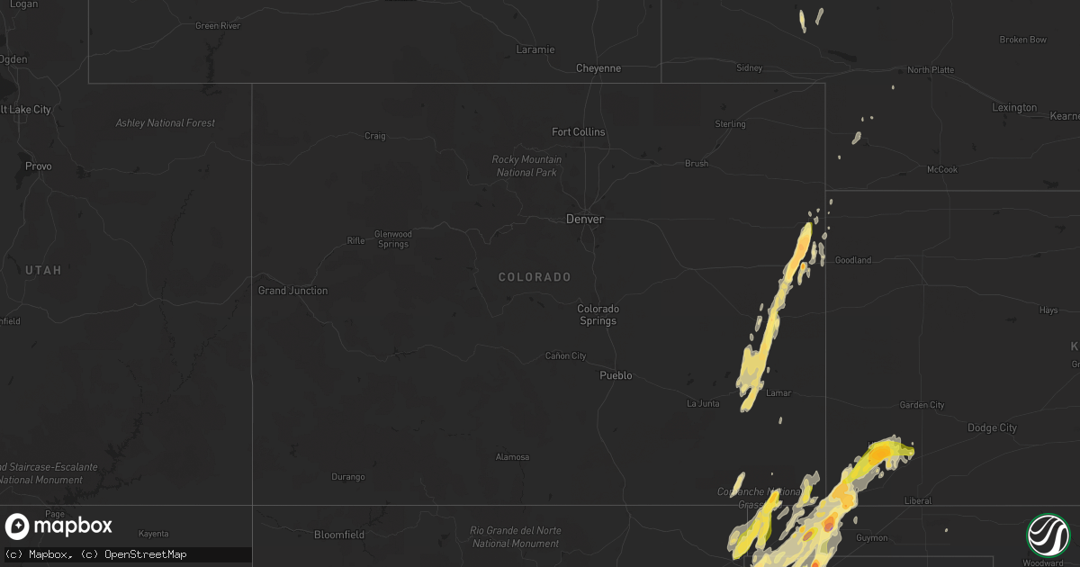
Hail Map in Colorado on April 15, 2016
Get this storm
April 15 map
$229
one time, instant access
Download today. No call, no setup
Keep the $229
Bought the map and want the full workflow? Apply the entire $229 to a subscription within 7 days. None of it is wasted.
Every map, not just this one
This buys you this map. Subscription and you get every map we run, in the markets you choose from a few cities to whole states to nationwide. Plus real-time alerts the moment a storm fires.
Contact data
Name, contact info, occupancy, even credit band for addresses in the footprint. You go from where it hit to who to call.
Become the source they trust
Unlimited branding weather history reports on demand. You already have the documented answer ready for the property owner, and you are the one who showed up with it.
Property data and RoofTrace estimates
Pull up any address you have got, its value and the exact code rules for that jurisdiction, straight from One Click Code. Then RoofTrace estimates the squares, pitch, and roof value, priced the way you price.
Storm reports in Colorado
Colorado
| Date | Description |
|---|---|
| 04/15/20166:30 PM CDT | A local report indicates 1.75 inch wind near BETHUNE |
| 04/15/20166:27 PM CDT | Storm produced 2-2.5 inch hail with time estimated from radar. Hail was observeda little while after storm passed. |
| 04/15/20166:23 PM CDT | Time estimated from radar. |
| 04/15/20166:15 PM CDT | A local report indicates 2.50 inch wind near 4 W BURLINGTON |
| 04/15/20166:15 PM CDT | A local report indicates 1.00 inch wind near 7 NNE BETHUNE |
| 04/15/20166:01 PM CDT | Revised time based on updated report and radar data. |
| 04/15/20165:49 PM CDT | Time estimated from radar. Periods of dime to golfball size hail occured from 4 pm mdt to roughly 530 pm mdt. Relayed by social media. |
| 04/15/20165:41 PM CDT | A local report indicates 1.75 inch wind near 5 ENE KIT CARSON |
| 04/15/20165:05 PM CDT | Size range 1-1.5 inch. |
| 04/15/20164:31 PM CDT | A local report indicates 1.00 inch wind near 5 S KIT CARSON |
| 04/15/20164:22 PM CDT | A local report indicates 1.00 inch wind near 5 S KIT CARSON |
| 04/15/20164:20 PM CDT | Via twitter |
| 04/15/20163:50 PM CDT | A local report indicates 1.50 inch wind near 5 SW EADS |
| 04/15/20163:25 PM CDT | A local report indicates a tornado near EADS |
| 04/15/20163:09 PM CDT | A local report indicates a tornado near 6 W NEEGRONDA RESERVOIR |
| 04/14/20168:23 PM CDT | A local report indicates 1.75 inch wind near 6 S CAMPO |
| 04/14/20167:16 PM CDT | Trained spotter near cty rd hh.5. Brief sighting... Quickly receded. |
All States Impacted by Hail Map on April 15, 2016
Cities Impacted by Hail Map on April 15, 2016
- Beaver, OK
- Springfield, CO
- Walsh, CO
- Campo, CO
- Keyes, OK
- Boise City, OK
- Kit Carson, CO
- Haswell, CO
- Eads, CO
- Burlington, CO
- Lake Worth, FL
- Boynton Beach, FL
- Stratford, TX
- Dumas, TX
- Bethune, CO
- Stratton, CO
- Sumterville, FL
- Webster, FL
- Bushnell, FL
- Kenansville, FL
- Amarillo, TX
- Boca Raton, FL
- Delray Beach, FL
- Dalhart, TX
- Miami Beach, FL
- Miami, FL
- Miami Gardens, FL
- North Miami Beach, FL
- Opa Locka, FL
- Oshkosh, NE
- Goodwell, OK
- Texline, TX
- Ulysses, KS
- Inverness, FL
- Channing, TX
- Hartley, TX
- Adrian, TX
- Floral City, FL
- Center Hill, FL
- Fort Pierce, FL
- Jupiter, FL
- Hobe Sound, FL
- Earth, TX
- Springlake, TX
- Olton, TX
- Felt, OK
- Hugoton, KS
- Rolla, KS
- Texhoma, OK
- Elkhart, KS
- Johnson, KS
- Richfield, KS
- Moscow, KS
- Hasty, CO
- McClave, CO
- Miami, TX
- Perryton, TX
- Kenton, OK
- Deerfield Beach, FL
- Pompano Beach, FL
- Homestead, FL
- Hereford, TX
- Wildorado, TX
- Clayton, NM
- Nara Visa, NM
- Logan, NM
- Port Saint Lucie, FL
- Saint Francis, KS
- Muleshoe, TX
- Palm Beach, FL
- Lake Worth Beach, FL
- West Palm Beach, FL
- Sedan, NM
- Wallace, NE
- Sunray, TX
- Pritchett, CO
- Las Animas, CO
- Idalia, CO
- Satanta, KS
- Palm Bay, FL
- Imperial, NE
- Grenville, NM
- Wauneta, NE
- Wray, CO
- Ashby, NE
- Lewellen, NE
- Stuart, FL
- Champion, NE
- Fort Lauderdale, FL
- Lamar, CO
- Parks, NE
- Kim, CO
- Immokalee, FL


