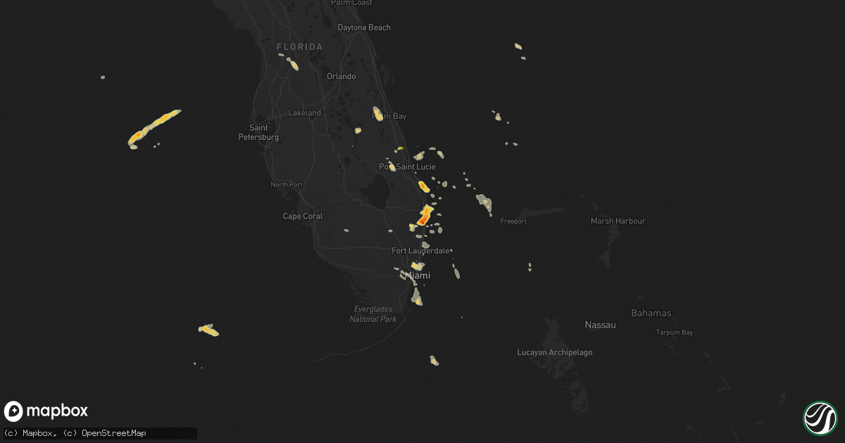
Hail Map on April 15, 2016
Get this storm
April 15 map
$229
one time, instant access
Download today. No call, no setup
Keep the $229
Bought the map and want the full workflow? Apply the entire $229 to a subscription within 7 days. None of it is wasted.
Every map, not just this one
This buys you this map. Subscription and you get every map we run, in the markets you choose from a few cities to whole states to nationwide. Plus real-time alerts the moment a storm fires.
Contact data
Name, contact info, occupancy, even credit band for addresses in the footprint. You go from where it hit to who to call.
Become the source they trust
Unlimited branding weather history reports on demand. You already have the documented answer ready for the property owner, and you are the one who showed up with it.
Property data and RoofTrace estimates
Pull up any address you have got, its value and the exact code rules for that jurisdiction, straight from One Click Code. Then RoofTrace estimates the squares, pitch, and roof value, priced the way you price.
Storm reports
New Mexico
| Date | Description |
|---|---|
| 04/15/20166:25 PM CDT | A local report indicates 1.25 inch wind near 3 E SENECA |
Texas
| Date | Description |
|---|---|
| 04/15/20166:59 PM CDT | Hail to the size of golf balls fell northwest of stratford. |
| 04/15/20166:50 PM CDT | Hail to the size of tennis balls was reported. |
| 04/15/20166:49 PM CDT | Hail up to quarter size was reported west of stratford. |
| 04/15/20166:39 PM CDT | A local report indicates 1.50 inch wind near CONLEN |
| 04/15/20166:20 PM CDT | Spotter reported golf ball size hail around 620 pm in dalhart. |
| 04/15/20165:56 PM CDT | A local report indicates 2.50 inch wind near 1 W DALHART |
| 04/15/20165:54 PM CDT | A local report indicates 1.75 inch wind near 1 N DALHART |
| 04/15/20165:52 PM CDT | Hail up to 2 inches in diameter was reported in dalhart. |
| 04/15/20165:52 PM CDT | A local report indicates 1.75 inch wind near 1 S DALHART |
| 04/15/20165:51 PM CDT | A local report indicates 1.50 inch wind near DALHART |
| 04/15/20165:51 PM CDT | Hail had just stopped falling. |
| 04/15/20165:50 PM CDT | A local report indicates 1.25 inch wind near 1 S DALHART |
| 04/15/20165:50 PM CDT | Hail to the size of half dollars was reported northeast of dalhart. |
| 04/15/20165:48 PM CDT | Hail estimated at the size of half dollars was reported in dalhart. |
| 04/15/20165:41 PM CDT | Hail of nickel up to quarter size was reported. |
| 04/15/20165:00 PM CDT | Golfball size hail was reported on the ground on fm 767 east of romero. |
| 04/15/20164:52 PM CDT | Hail was falling at the time |
| 04/15/20164:19 PM CDT | A local report indicates 1.75 inch wind near 3 NW WARE |
| 04/15/201612:50 AM CDT | Hail of up to half dollar size was continuing to fall east of dalhart. |
| 04/15/201612:45 AM CDT | Hail of up to quarter size hail was falling near bishop hills. |
| 04/15/201612:38 AM CDT | Hail to the size of golf balls was continuing to fall in dalhart. |
| 04/15/201612:35 AM CDT | A local report indicates 1.75 inch wind near 2 W BUSHLAND |
| 04/15/201612:30 AM CDT | A local report indicates 1.75 inch wind near 1 N DALHART |
| 04/14/201611:44 PM CDT | Hail up to the size of half dollars fell west of cactus. |
| 04/14/20169:50 PM CDT | Tornado on the ground for about 1 minute west of boys ranch and north of adrian. |
| 04/14/20169:33 PM CDT | Hail to the size of golf balls fell and damaged some porch skylights southwest of dumas |
| 04/14/20168:30 PM CDT | Hail to the size of golf balls fell south of texline. |
| 04/14/20168:15 PM CDT | A local report indicates 1.00 inch wind near TEXLINE |
Colorado
| Date | Description |
|---|---|
| 04/15/20166:30 PM CDT | A local report indicates 1.75 inch wind near BETHUNE |
| 04/15/20166:27 PM CDT | Storm produced 2-2.5 inch hail with time estimated from radar. Hail was observeda little while after storm passed. |
| 04/15/20166:23 PM CDT | Time estimated from radar. |
| 04/15/20166:15 PM CDT | A local report indicates 2.50 inch wind near 4 W BURLINGTON |
| 04/15/20166:15 PM CDT | A local report indicates 1.00 inch wind near 7 NNE BETHUNE |
| 04/15/20166:01 PM CDT | Revised time based on updated report and radar data. |
| 04/15/20165:49 PM CDT | Time estimated from radar. Periods of dime to golfball size hail occured from 4 pm mdt to roughly 530 pm mdt. Relayed by social media. |
| 04/15/20165:41 PM CDT | A local report indicates 1.75 inch wind near 5 ENE KIT CARSON |
| 04/15/20165:05 PM CDT | Size range 1-1.5 inch. |
| 04/15/20164:31 PM CDT | A local report indicates 1.00 inch wind near 5 S KIT CARSON |
| 04/15/20164:22 PM CDT | A local report indicates 1.00 inch wind near 5 S KIT CARSON |
| 04/15/20164:20 PM CDT | Via twitter |
| 04/15/20163:50 PM CDT | A local report indicates 1.50 inch wind near 5 SW EADS |
| 04/15/20163:25 PM CDT | A local report indicates a tornado near EADS |
| 04/15/20163:09 PM CDT | A local report indicates a tornado near 6 W NEEGRONDA RESERVOIR |
| 04/14/20168:23 PM CDT | A local report indicates 1.75 inch wind near 6 S CAMPO |
| 04/14/20167:16 PM CDT | Trained spotter near cty rd hh.5. Brief sighting... Quickly receded. |
Oklahoma
| Date | Description |
|---|---|
| 04/15/20166:00 PM CDT | Ping pong ball size hail was reported west of wheeless. |
| 04/15/20161:55 PM CDT | Hail up to 2 inches in diameter fell southwest of yarbrough. |
| 04/14/201610:04 PM CDT | Hail up to 2 inches in diameter was reported along state hwy 171 north of kerrick. |
| 04/14/20169:05 PM CDT | Copious amounts of quarter size hail were falling northwest of sturgis. |
| 04/14/20168:19 PM CDT | Tornado was on the ground for several minutes north of eva and near state hwy 95. |
| 04/14/20168:16 PM CDT | Tornado was on the ground for several minutes north of eva and west of state hwy 95. |
| 04/14/20168:02 PM CDT | This tornado was on the ground around a couple minutes |
| 04/14/20167:56 PM CDT | Tornado lasted about 3 minutes |
| 04/14/20167:50 PM CDT | Several reports of a tornado on the ground for less than 1 minute southwest of eva and northwest of texhoma. |
| 04/14/20167:00 PM CDT | Hail to the size of half dollars was reported. |
Kansas
| Date | Description |
|---|---|
| 04/15/20162:19 PM CDT | Delayed report from yesterday's storms. |
| 04/14/201610:53 PM CDT | A local report indicates 1.00 inch wind near 5 N SATANTA |
| 04/14/201610:21 PM CDT | A local report indicates 1.00 inch wind near ULYSSES |
| 04/14/201610:20 PM CDT | A local report indicates 1.50 inch wind near 2 SSW ULYSSES |
| 04/14/201610:10 PM CDT | A local report indicates 1.75 inch wind near 8 SSW ULYSSES |
| 04/14/201610:08 PM CDT | A local report indicates 1.00 inch wind near 5 W ULYSSES |
| 04/14/20169:50 PM CDT | A local report indicates 1.00 inch wind near 13 ENE RICHFIELD |
| 04/14/20169:37 PM CDT | A local report indicates 1.25 inch wind near 3 E RICHFIELD |
| 04/14/20169:21 PM CDT | A local report indicates 1.00 inch wind near 2 NE WILBURTON |
| 04/14/20169:19 PM CDT | Delayed report from yesterday's storms. |
| 04/14/20169:17 PM CDT | Rope tornado reported |
| 04/14/20168:32 PM CDT | A local report indicates 1.75 inch wind near 5 SSE WILBURTON |
Florida
| Date | Description |
|---|---|
| 04/15/20165:25 PM CDT | A trained spotter called to report half dollar size hail in west delray beach at 625pm |
| 04/15/20165:20 PM CDT | A trained spotter reported via twitter golf ball size hail in west boynton beach at 620pm |
| 04/15/20165:15 PM CDT | Quarter size hail reported... Along with large tree limbs broken off by strong wind estimated at least 50 mph. |
| 04/15/20165:11 PM CDT | A trained spotter called to report quarter inch hail in boynton beach at 611pm |
| 04/15/20165:05 PM CDT | Video obtained via broadcast media of hail slightly larger than golf ball size in lantana near federal highway and hypoluxo road. |
| 04/15/20164:57 PM CDT | A trained spotter called to report quarter inch size hail in lake worth at 557pm |
| 04/15/20164:48 PM CDT | A trained spotter called in a report of quarter size hail in lake worth florida at 537pm |
| 04/15/20164:45 PM CDT | Near i-95 and 10th avenue |
| 04/15/20164:35 PM CDT | Media reported ping pong size hail near forest hill blvd and s flager drive at 535pm |
| 04/15/20164:00 PM CDT | A local report indicates 1.50 inch wind near 4 N JUPITER |
Cities Impacted by Hail Map on April 15, 2016
- Beaver, OK
- Springfield, CO
- Walsh, CO
- Campo, CO
- Keyes, OK
- Boise City, OK
- Kit Carson, CO
- Haswell, CO
- Eads, CO
- Burlington, CO
- Lake Worth, FL
- Boynton Beach, FL
- Stratford, TX
- Dumas, TX
- Bethune, CO
- Stratton, CO
- Sumterville, FL
- Webster, FL
- Bushnell, FL
- Kenansville, FL
- Amarillo, TX
- Boca Raton, FL
- Delray Beach, FL
- Dalhart, TX
- Miami Beach, FL
- Miami, FL
- Miami Gardens, FL
- North Miami Beach, FL
- Opa Locka, FL
- Oshkosh, NE
- Goodwell, OK
- Texline, TX
- Ulysses, KS
- Inverness, FL
- Channing, TX
- Hartley, TX
- Adrian, TX
- Floral City, FL
- Center Hill, FL
- Fort Pierce, FL
- Jupiter, FL
- Hobe Sound, FL
- Earth, TX
- Springlake, TX
- Olton, TX
- Felt, OK
- Hugoton, KS
- Rolla, KS
- Texhoma, OK
- Elkhart, KS
- Johnson, KS
- Richfield, KS
- Moscow, KS
- Hasty, CO
- McClave, CO
- Miami, TX
- Perryton, TX
- Kenton, OK
- Deerfield Beach, FL
- Pompano Beach, FL
- Homestead, FL
- Hereford, TX
- Wildorado, TX
- Clayton, NM
- Nara Visa, NM
- Logan, NM
- Port Saint Lucie, FL
- Saint Francis, KS
- Muleshoe, TX
- Palm Beach, FL
- Lake Worth Beach, FL
- West Palm Beach, FL
- Sedan, NM
- Wallace, NE
- Sunray, TX
- Pritchett, CO
- Las Animas, CO
- Idalia, CO
- Satanta, KS
- Palm Bay, FL
- Imperial, NE
- Grenville, NM
- Wauneta, NE
- Wray, CO
- Ashby, NE
- Lewellen, NE
- Stuart, FL
- Champion, NE
- Fort Lauderdale, FL
- Lamar, CO
- Parks, NE
- Kim, CO
- Immokalee, FL