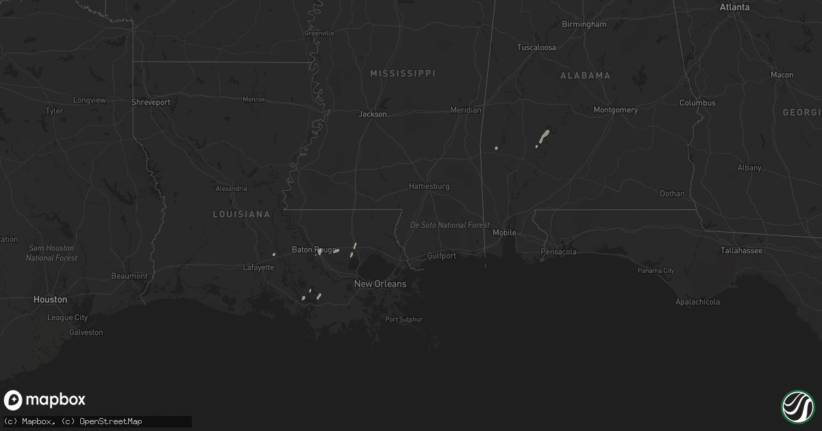
Hail Map in Alabama on April 14, 2018
Get this storm
April 14 map
$229
one time, instant access
Download today. No call, no setup
Keep the $229
Bought the map and want the full workflow? Apply the entire $229 to a subscription within 7 days. None of it is wasted.
Every map, not just this one
This buys you this map. Subscription and you get every map we run, in the markets you choose from a few cities to whole states to nationwide. Plus real-time alerts the moment a storm fires.
Contact data
Name, contact info, occupancy, even credit band for addresses in the footprint. You go from where it hit to who to call.
Become the source they trust
Unlimited branding weather history reports on demand. You already have the documented answer ready for the property owner, and you are the one who showed up with it.
Property data and RoofTrace estimates
Pull up any address you have got, its value and the exact code rules for that jurisdiction, straight from One Click Code. Then RoofTrace estimates the squares, pitch, and roof value, priced the way you price.
Storm reports in Alabama
Alabama
| Date | Description |
|---|---|
| 04/14/20185:25 PM CDT | Tree on house. |
| 04/14/20185:25 PM CDT | Tree on house. |
| 04/14/20183:15 PM CDT | Large tree down on vestaview lane. Winds estimated 40-50 mph. |
| 04/14/20182:52 PM CDT | A nws survey team investigated public-reported storm damage either side of highway 13 near honeysuckle road... And along highway 93. This damage was associated with an |
| 04/14/201812:05 PM CDT | Tree down on house and truck. |
| 04/14/201811:30 AM CDT | At least 6 tree down at the intersection of county road 49 and little hells creek road. |
| 04/14/20188:38 AM CDT | County shed damaged off highway 99. Time estimated from radar. |
| 04/14/20187:24 AM CDT | At 1223 PM CDT, severe thunderstorms were located along a line extending from near Carrollton to near Benevola to near Allison, moving northeast at 40 mph. HAZARD...60 mph wind gusts. SOURCE...Radar indicated. IMPACT...Expect damage to roofs, siding, and trees. Locations impacted include... Tuscaloosa, Northport, Holt, Lake View, Brookwood, Coaling, Coker, Bull City, Samantha, McFarland Mall, Lake Lurleen State Park, Tuscaloosa Amphitheater, Tuscaloosa Regional Airport, Lake Wildwood, Binion Creek Landing, Abernant, Shelton State Community College, Bryant Denny Stadium, University Mall and Deerlick Creek Campgrounds. |
| 04/14/20186:59 AM CDT | At 1158 AM CDT, severe thunderstorms were located along a line extending from near Snell to 12 miles southwest of State Line, moving northeast at 65 mph. HAZARD...60 mph wind gusts. SOURCE...Radar indicated. IMPACT...Expect damage to roofs, siding, and trees. Locations impacted include... Jackson, Waynesboro, Thomasville, Butler, Grove Hill, Chatom, Saint Stephens, Leroy, Lisman, Millry, State Line, Buckatunna, Silas, Fruitdale, Coffeeville, Pennington, Gilbertown and Toxey. |
| 04/14/20186:55 AM CDT | At 1155 AM CDT, severe thunderstorms were located along a line extending from 7 miles southwest of McMullen to New West Greene to near Livingston, moving northeast at 40 mph. HAZARD...60 mph wind gusts. SOURCE...Radar indicated. IMPACT...Expect damage to roofs, siding, and trees. Locations impacted include... Eutaw, Aliceville, Gordo, Reform, Carrollton, Pickensville, Boligee, Union, Epes, Ethelsville, McMullen, West Greene, Benevola, Johnston Lake, Bevill Lock And Dam, Garden, Ashcraft Corner, New West Greene, Mantua and Allison. |
| 04/14/20186:53 AM CDT | At 1153 AM CDT, severe thunderstorms were located along a line extending from 6 miles northwest of Brilliant to near Gordo, moving northeast at 55 mph. HAZARD...60 mph wind gusts. SOURCE...Radar indicated. IMPACT...Expect damage to roofs, siding, and trees. Locations impacted include... Hamilton, Winfield, Fayette, Guin, Berry, Brilliant, Glen Allen, Belk, Gu- Win, Bankston, Bluff, Boley Springs, Brinn, Lake Buttahatchee, Bear Creek, Twin, Tucker, Stone Wall, Wayside and Richard Arthur Field. |
| 04/14/20186:24 AM CDT | At 1123 AM CDT, a severe thunderstorm was located near Electric Mills, or 14 miles north of Meridian Station, moving northeast at 35 mph. HAZARD...60 mph wind gusts. SOURCE...Radar indicated. IMPACT...Expect damage to roofs, siding, and trees. This severe thunderstorm will be near... Electric Mills around 1130 AM CDT. Cooksville around 1155 AM CDT. Other locations impacted by this severe thunderstorm include Scooba. |
| 04/14/20186:22 AM CDT | At 1122 AM CDT, a severe thunderstorm was located over Goodwater, or 11 miles southwest of Quitman, moving northeast at 40 mph. HAZARD...60 mph wind gusts. SOURCE...Radar indicated. IMPACT...Expect damage to roofs, siding, and trees. This severe thunderstorm will be near... De Soto around 1135 AM CDT. Quitman around 1140 AM CDT. Crandall around 1150 AM CDT. Sykes and Middleton around 1155 AM CDT. Snell around 1205 PM CDT. Other locations impacted by this severe thunderstorm include Pachutaand Shubuta. |
| 04/14/20184:53 AM CDT | At 953 AM CDT, a severe thunderstorm was located near Turnerville, or 15 miles north of Stringer, moving east at 30 mph. HAZARD...60 mph wind gusts. SOURCE...Radar indicated. IMPACT...Expect damage to roofs, siding, and trees. This severe thunderstorm will be near... Paulding around 1010 AM CDT. Rose Hill around 1020 AM CDT. Orange around 1025 AM CDT. Stonewall around 1040 AM CDT. Quitman around 1050 AM CDT. Sable around 1055 AM CDT. Middleton around 1100 AM CDT. Sykes around 1105 AM CDT. Other locations impacted by this severe thunderstorm include Pachuta,Shubuta, Montrose and Louin. |
| 04/14/20184:50 AM CDT | At 950 PM CDT, a severe thunderstorm was located 6 miles west of I65 And US 84, or 9 miles west of Evergreen, moving northeast at 40 mph. HAZARD...60 mph wind gusts and penny size hail. SOURCE...Radar indicated. IMPACT...Expect damage to roofs, siding, and trees. Locations impacted include... Evergreen, Georgiana, McKenzie and I65 And US 84. |
| 04/14/20184:03 AM CDT | At 902 PM CDT, a severe thunderstorm was located near Magnolia Springs, or 8 miles southwest of Foley, moving northeast at 25 mph. HAZARD...60 mph wind gusts. SOURCE...Radar indicated. IMPACT...Expect damage to roofs, siding, and trees. Locations impacted include... Foley, Magnolia Springs, Bon Secour, Summerdale and Elberta. |
| 04/14/20183:32 AM CDT | At 832 AM CDT, severe thunderstorms were located along a line extending from 8 miles southeast of Rogersville to near Moulton, moving east at 40 mph. HAZARD...60 mph wind gusts. SOURCE...Radar indicated. IMPACT...Expect damage to roofs, siding, and trees. Locations impacted include... Decatur, Athens, Hartselle, Moulton, Priceville, Trinity, Tanner, Hillsboro, Mooresville and Belle Mina. |
| 04/14/20181:49 AM CDT | At 649 AM CDT, a severe thunderstorm was located over New Salem, or near Fulton, moving east at 50 mph. HAZARD...60 mph wind gusts. SOURCE...Radar indicated. IMPACT...Expect damage to roofs, siding, and trees. Locations impacted include... Hamilton, Weston, Byrd, Bexar, Pigeye, Shottsville and Rankin Fite Airport. |
| 04/14/201812:47 AM CDT | At 546 AM CDT, a severe thunderstorm was located near New Harmony, or 11 miles north of Trace State Park, moving east at 50 mph. HAZARD...60 mph wind gusts. SOURCE...Radar indicated. IMPACT...Expect damage to roofs, siding, and trees. Locations impacted include... Tupelo, Fulton, Baldwyn, Red Bay, Verona, Tombigbee State Park, Tishomingo State Park, Saltillo, Guntown, Belmont, Shannon, Plantersville, Mantachie, Tremont, Fairview, Pratts Friendship, New Salem, Sandy Springs, Blair and Evergreen. |
| 04/14/201812:39 AM CDT | At 538 AM CDT, a severe thunderstorm was located near Ripley, moving northeast at 50 mph. HAZARD...60 mph wind gusts. SOURCE...Radar indicated. IMPACT...Expect damage to roofs, siding, and trees. Locations impacted include... Booneville, Iuka, Tishomingo State Park, Burnsville, Jumpertown, Tishomingo, Thrashers, Hinkle, Burton, Midway, Wheeler, Leedy, Dumas, Rienzi, Paden, Oldham, Graham, Blythe Crossing, Gaston and Carter Branch. |
| 04/13/20189:11 PM CDT | Sporadic damage at a burlington coat factory and surrounding areas near the corner of airport blvd and i-65. |
| 04/13/20188:39 PM CDT | At 138 PM CDT, severe thunderstorms were located along a line extending from near Moundville to near Magnolia, moving northeast at 25 mph. HAZARD...60 mph wind gusts. SOURCE...Radar indicated. IMPACT...Expect damage to roofs, siding, and trees. Locations impacted include... Marion, Greensboro, Uniontown, Moundville, Thomaston, Newbern, Faunsdale, Dayton, Vaiden, Central Mills, Greensboro Municipal Airport, Low Gap, Mertz, Safford, Moundville Airport, Folsom, Mound State Park, Elliots Creek, Harper Hill and Vaiden Field Airport. |
| 04/13/20188:21 PM CDT | At 121 PM CDT, a severe thunderstorm was located near Arley, moving northeast at 20 mph. HAZARD...60 mph wind gusts. SOURCE...Radar indicated. IMPACT...Expect damage to roofs, siding, and trees. Locations impacted include... Baldwin, West Point, Logan, Crane Hill, Jones Chapel and Smith Lake. |


