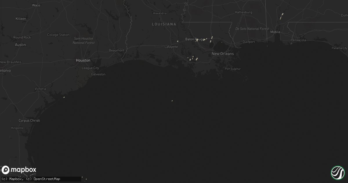
Hail Map on April 14, 2018
Get this storm
April 14 map
$229
one time, instant access
Download today. No call, no setup
Keep the $229
Bought the map and want the full workflow? Apply the entire $229 to a subscription within 7 days. None of it is wasted.
Every map, not just this one
This buys you this map. Subscription and you get every map we run, in the markets you choose from a few cities to whole states to nationwide. Plus real-time alerts the moment a storm fires.
Contact data
Name, contact info, occupancy, even credit band for addresses in the footprint. You go from where it hit to who to call.
Become the source they trust
Unlimited branding weather history reports on demand. You already have the documented answer ready for the property owner, and you are the one who showed up with it.
Property data and RoofTrace estimates
Pull up any address you have got, its value and the exact code rules for that jurisdiction, straight from One Click Code. Then RoofTrace estimates the squares, pitch, and roof value, priced the way you price.
Storm reports
Alabama
| Date | Description |
|---|---|
| 04/14/20185:25 PM CDT | Tree on house. |
| 04/14/20185:25 PM CDT | Tree on house. |
| 04/14/20183:15 PM CDT | Large tree down on vestaview lane. Winds estimated 40-50 mph. |
| 04/14/20182:52 PM CDT | A nws survey team investigated public-reported storm damage either side of highway 13 near honeysuckle road... And along highway 93. This damage was associated with an |
| 04/14/201812:05 PM CDT | Tree down on house and truck. |
| 04/14/201811:30 AM CDT | At least 6 tree down at the intersection of county road 49 and little hells creek road. |
| 04/14/20188:38 AM CDT | County shed damaged off highway 99. Time estimated from radar. |
| 04/14/20187:24 AM CDT | At 1223 PM CDT, severe thunderstorms were located along a line extending from near Carrollton to near Benevola to near Allison, moving northeast at 40 mph. HAZARD...60 mph wind gusts. SOURCE...Radar indicated. IMPACT...Expect damage to roofs, siding, and trees. Locations impacted include... Tuscaloosa, Northport, Holt, Lake View, Brookwood, Coaling, Coker, Bull City, Samantha, McFarland Mall, Lake Lurleen State Park, Tuscaloosa Amphitheater, Tuscaloosa Regional Airport, Lake Wildwood, Binion Creek Landing, Abernant, Shelton State Community College, Bryant Denny Stadium, University Mall and Deerlick Creek Campgrounds. |
| 04/14/20186:59 AM CDT | At 1158 AM CDT, severe thunderstorms were located along a line extending from near Snell to 12 miles southwest of State Line, moving northeast at 65 mph. HAZARD...60 mph wind gusts. SOURCE...Radar indicated. IMPACT...Expect damage to roofs, siding, and trees. Locations impacted include... Jackson, Waynesboro, Thomasville, Butler, Grove Hill, Chatom, Saint Stephens, Leroy, Lisman, Millry, State Line, Buckatunna, Silas, Fruitdale, Coffeeville, Pennington, Gilbertown and Toxey. |
| 04/14/20186:55 AM CDT | At 1155 AM CDT, severe thunderstorms were located along a line extending from 7 miles southwest of McMullen to New West Greene to near Livingston, moving northeast at 40 mph. HAZARD...60 mph wind gusts. SOURCE...Radar indicated. IMPACT...Expect damage to roofs, siding, and trees. Locations impacted include... Eutaw, Aliceville, Gordo, Reform, Carrollton, Pickensville, Boligee, Union, Epes, Ethelsville, McMullen, West Greene, Benevola, Johnston Lake, Bevill Lock And Dam, Garden, Ashcraft Corner, New West Greene, Mantua and Allison. |
| 04/14/20186:53 AM CDT | At 1153 AM CDT, severe thunderstorms were located along a line extending from 6 miles northwest of Brilliant to near Gordo, moving northeast at 55 mph. HAZARD...60 mph wind gusts. SOURCE...Radar indicated. IMPACT...Expect damage to roofs, siding, and trees. Locations impacted include... Hamilton, Winfield, Fayette, Guin, Berry, Brilliant, Glen Allen, Belk, Gu- Win, Bankston, Bluff, Boley Springs, Brinn, Lake Buttahatchee, Bear Creek, Twin, Tucker, Stone Wall, Wayside and Richard Arthur Field. |
| 04/14/20186:24 AM CDT | At 1123 AM CDT, a severe thunderstorm was located near Electric Mills, or 14 miles north of Meridian Station, moving northeast at 35 mph. HAZARD...60 mph wind gusts. SOURCE...Radar indicated. IMPACT...Expect damage to roofs, siding, and trees. This severe thunderstorm will be near... Electric Mills around 1130 AM CDT. Cooksville around 1155 AM CDT. Other locations impacted by this severe thunderstorm include Scooba. |
| 04/14/20186:22 AM CDT | At 1122 AM CDT, a severe thunderstorm was located over Goodwater, or 11 miles southwest of Quitman, moving northeast at 40 mph. HAZARD...60 mph wind gusts. SOURCE...Radar indicated. IMPACT...Expect damage to roofs, siding, and trees. This severe thunderstorm will be near... De Soto around 1135 AM CDT. Quitman around 1140 AM CDT. Crandall around 1150 AM CDT. Sykes and Middleton around 1155 AM CDT. Snell around 1205 PM CDT. Other locations impacted by this severe thunderstorm include Pachutaand Shubuta. |
| 04/14/20184:53 AM CDT | At 953 AM CDT, a severe thunderstorm was located near Turnerville, or 15 miles north of Stringer, moving east at 30 mph. HAZARD...60 mph wind gusts. SOURCE...Radar indicated. IMPACT...Expect damage to roofs, siding, and trees. This severe thunderstorm will be near... Paulding around 1010 AM CDT. Rose Hill around 1020 AM CDT. Orange around 1025 AM CDT. Stonewall around 1040 AM CDT. Quitman around 1050 AM CDT. Sable around 1055 AM CDT. Middleton around 1100 AM CDT. Sykes around 1105 AM CDT. Other locations impacted by this severe thunderstorm include Pachuta,Shubuta, Montrose and Louin. |
| 04/14/20184:50 AM CDT | At 950 PM CDT, a severe thunderstorm was located 6 miles west of I65 And US 84, or 9 miles west of Evergreen, moving northeast at 40 mph. HAZARD...60 mph wind gusts and penny size hail. SOURCE...Radar indicated. IMPACT...Expect damage to roofs, siding, and trees. Locations impacted include... Evergreen, Georgiana, McKenzie and I65 And US 84. |
| 04/14/20184:03 AM CDT | At 902 PM CDT, a severe thunderstorm was located near Magnolia Springs, or 8 miles southwest of Foley, moving northeast at 25 mph. HAZARD...60 mph wind gusts. SOURCE...Radar indicated. IMPACT...Expect damage to roofs, siding, and trees. Locations impacted include... Foley, Magnolia Springs, Bon Secour, Summerdale and Elberta. |
| 04/14/20183:32 AM CDT | At 832 AM CDT, severe thunderstorms were located along a line extending from 8 miles southeast of Rogersville to near Moulton, moving east at 40 mph. HAZARD...60 mph wind gusts. SOURCE...Radar indicated. IMPACT...Expect damage to roofs, siding, and trees. Locations impacted include... Decatur, Athens, Hartselle, Moulton, Priceville, Trinity, Tanner, Hillsboro, Mooresville and Belle Mina. |
| 04/14/20181:49 AM CDT | At 649 AM CDT, a severe thunderstorm was located over New Salem, or near Fulton, moving east at 50 mph. HAZARD...60 mph wind gusts. SOURCE...Radar indicated. IMPACT...Expect damage to roofs, siding, and trees. Locations impacted include... Hamilton, Weston, Byrd, Bexar, Pigeye, Shottsville and Rankin Fite Airport. |
| 04/14/201812:47 AM CDT | At 546 AM CDT, a severe thunderstorm was located near New Harmony, or 11 miles north of Trace State Park, moving east at 50 mph. HAZARD...60 mph wind gusts. SOURCE...Radar indicated. IMPACT...Expect damage to roofs, siding, and trees. Locations impacted include... Tupelo, Fulton, Baldwyn, Red Bay, Verona, Tombigbee State Park, Tishomingo State Park, Saltillo, Guntown, Belmont, Shannon, Plantersville, Mantachie, Tremont, Fairview, Pratts Friendship, New Salem, Sandy Springs, Blair and Evergreen. |
| 04/14/201812:39 AM CDT | At 538 AM CDT, a severe thunderstorm was located near Ripley, moving northeast at 50 mph. HAZARD...60 mph wind gusts. SOURCE...Radar indicated. IMPACT...Expect damage to roofs, siding, and trees. Locations impacted include... Booneville, Iuka, Tishomingo State Park, Burnsville, Jumpertown, Tishomingo, Thrashers, Hinkle, Burton, Midway, Wheeler, Leedy, Dumas, Rienzi, Paden, Oldham, Graham, Blythe Crossing, Gaston and Carter Branch. |
| 04/13/20189:11 PM CDT | Sporadic damage at a burlington coat factory and surrounding areas near the corner of airport blvd and i-65. |
| 04/13/20188:39 PM CDT | At 138 PM CDT, severe thunderstorms were located along a line extending from near Moundville to near Magnolia, moving northeast at 25 mph. HAZARD...60 mph wind gusts. SOURCE...Radar indicated. IMPACT...Expect damage to roofs, siding, and trees. Locations impacted include... Marion, Greensboro, Uniontown, Moundville, Thomaston, Newbern, Faunsdale, Dayton, Vaiden, Central Mills, Greensboro Municipal Airport, Low Gap, Mertz, Safford, Moundville Airport, Folsom, Mound State Park, Elliots Creek, Harper Hill and Vaiden Field Airport. |
| 04/13/20188:21 PM CDT | At 121 PM CDT, a severe thunderstorm was located near Arley, moving northeast at 20 mph. HAZARD...60 mph wind gusts. SOURCE...Radar indicated. IMPACT...Expect damage to roofs, siding, and trees. Locations impacted include... Baldwin, West Point, Logan, Crane Hill, Jones Chapel and Smith Lake. |
North Carolina
| Date | Description |
|---|---|
| 04/14/20184:45 AM CDT | Lots of structural and tree damage. Possible tornado. |
| 04/14/20183:45 AM CDT | Multiple large oak trees uprooted or snapped in half. Shingles off house. Indicated possible tornado. |
Virginia
| Date | Description |
|---|---|
| 04/14/20186:09 PM CDT | Numerous houses damaged along route 130. Relayed by broadcast media. |
| 04/14/20185:54 AM CDT | Tree down on tinkerville road. Time radar estimated. |
| 04/14/20185:54 AM CDT | Two trees down on brattons run road. |
| 04/13/201810:20 PM CDT | *** 8 inj *** amherst county em very confident that a tornado occurred in the vicinity of elon road... Nottoway drive... Deerfield drive... And hunt club road in the el |
| 04/13/20189:15 PM CDT | Roof removed from an old and rotted wooden shed. Damage consistent with straight line winds. |
Tennessee
| Date | Description |
|---|---|
| 04/14/20188:36 AM CDT | Report of several trees down. Time is estimated from the radar. |
| 04/14/20188:32 AM CDT | Report of two trees leaning on wires. One is on lauderdale road... The other is on bear road. Time is estimated from radar. |
| 04/14/20188:12 AM CDT | Received a report of trees and power lines down in the 2500 block of highway 13. In addition there was roof and carport damage to a structure at 2516. Time is estimated |
| 04/14/20188:02 AM CDT | Dispatch reported several trees down in the north central part of the county near ashland city. |
| 04/14/20187:19 AM CDT | Received a report of trees and power lines down in the 2500 block of highway 13. In addition there was roof and carport damage to a structure at 2516. Time is estimated |
| 04/14/20187:00 AM CDT | The majority of a tin roof was removed from a home on north buchanan rd. Event time was estimated from radar. |
| 04/14/20183:31 AM CDT | At 831 AM CDT, a severe thunderstorm was located over Cross Plains, or 10 miles east of Springfield, moving east at 35 mph. HAZARD...60 mph wind gusts. SOURCE...Radar indicated. IMPACT...Expect damage to roofs, siding, and trees. Locations impacted include... Gallatin, White House, Millersville, Westmoreland, Cross Plains, Cottontown, Bethpage, Oak Grove and Bledsoe Creek State Park.This includes Interstate 65 between mile markers 105 and 115. |
| 04/14/20183:12 AM CDT | At 812 AM CDT, a severe thunderstorm was located near Coopertown, or 9 miles northeast of Ashland City, moving southeast at 45 mph. HAZARD...60 mph wind gusts. SOURCE...Radar indicated. IMPACT...Expect damage to roofs, siding, and trees. Locations impacted include... Gallatin, Madison, Hendersonville, Goodlettsville, Millersville, Greenbrier, Coopertown, Lakewood, Ridgetop, Hermitage, Old Hickory, Joelton, Pleasant View and Whites Creek.This includes the following highways... Interstate 40 between mile markers 215 and 221. Interstate 65 between mile markers 87 and 105. Interstate 24 between mile markers 27 and 47. |
| 04/14/20182:12 AM CDT | At 712 AM CDT, severe thunderstorms were located along a line extending from 8 miles north of Underwood-Petersville to 8 miles southeast of Red Bay, moving north northeast at 30 mph. HAZARD...60 mph wind gusts and nickel size hail. SOURCE...Radar indicated. IMPACT...Expect damage to roofs, siding, and trees. Locations impacted include... Florence, Muscle Shoals, Russellville, Sheffield, Tuscumbia, Killen, Littleville, St. Florian, Underwood-Petersville and Belgreen. |
| 04/14/201812:30 AM CDT | At 530 AM CDT, a severe thunderstorm was located over Masseyville, or 8 miles southeast of Chickasaw State Forest, moving northeast at 50 mph. HAZARD...60 mph wind gusts. SOURCE...Radar indicated. IMPACT...Expect damage to roofs, siding, and trees. Locations impacted include... Lexington, Savannah, Henderson, Selmer, Parsons, Adamsville, Decaturville, Sardis, Reagan, Mifflin, Morris Chapel, Jacks Creek, Olive Hill, Darden, Montgomery, Crump, Scotts Hill, Bethel Springs, Eastview and Saltillo. |
| 04/13/201811:14 PM CDT | At 413 AM CDT, a severe thunderstorm was located near Byhalia, or 12 miles southeast of Olive Branch, moving northeast at 55 mph. HAZARD...60 mph wind gusts. SOURCE...Radar indicated. IMPACT...Expect damage to roofs, siding, and trees. Locations impacted include... Holly Springs, Bolivar, Lamar, Whiteville, Somerville, Byhalia, Snow Lake Shores, Canaan, Mt Pleasant, Lagrange, Michigan City, Red Banks, Slayden, Marianna, Macon, Piperton, Rossville, Ashland, Moscow and Williston. |
Arkansas
| Date | Description |
|---|---|
| 04/13/201811:06 PM CDT | At 405 AM CDT, severe thunderstorms were located along a line extending from Eudora to near Gassoway to near Lake Providence, moving east at 55 mph. HAZARD...60 mph wind gusts. SOURCE...Radar indicated. IMPACT...Expect damage to roofs, siding, and trees. Severe thunderstorms will be near... Glen Allan around 415 AM CDT. Avon, Grace and Wayside around 420 AM CDT. Panther Burn and Nitta Yuma around 425 AM CDT. Hollandale, Rolling Fork, Estill and Delta City around 430 AM CDT. Anguilla and Darlove around 435 AM CDT. Murphy around 440 AM CDT. Other locations impacted by these severe thunderstorms includeMayersville. |
Texas
| Date | Description |
|---|---|
| 04/14/20187:59 AM CDT | At 1259 AM CDT, severe thunderstorms were located along a line extending from 6 miles east of Taylor to near Shongaloo to Minden to 7 miles northwest of Ringgold to 9 miles east of Mansfield to 9 miles northwest of Converse, moving east at 75 mph. HAZARD...60 mph wind gusts and penny size hail. SOURCE...Radar indicated. IMPACT...Expect damage to roofs, siding, and trees. Locations impacted include... Ruston, El Dorado, Minden, Magnolia, Mansfield, Grambling, Jonesboro, Homer, Smackover, Norphlet, Farmerville, Arcadia, Haynesville, Coushatta, Bernice, Ringgold, Sibley, Campti, Gibsland and Doyline. |
| 04/14/20187:25 AM CDT | At 1225 AM CDT, a severe thunderstorm was located 7 miles north of Los Angeles, or 10 miles southeast of Dilley, moving east at 50 mph. HAZARD...60 mph wind gusts and quarter size hail. SOURCE...Radar indicated. IMPACT...Hail damage to vehicles is expected. Expect wind damage to roofs, siding, and trees. Locations impacted include... Tilden, Calliham, Zella, Cross, Fowlerton, Crowther and Los Angeles. |
| 04/14/20187:15 AM CDT | At 1214 AM CDT, severe thunderstorms were located along a line extending from 8 miles southeast of Fouke to near Plain Dealing to near Logansport, moving southeast at 50 mph. HAZARD...60 mph wind gusts and penny size hail. SOURCE...Radar indicated. IMPACT...Expect damage to roofs, siding, and trees. Locations impacted include... Shreveport, Bossier City, Minden, Springhill, Mansfield, Stamps, Waldo, Lewisville, Haughton, Greenwood, Blanchard, Coushatta, Benton, Stonewall, Ringgold, Sibley, Cullen, Plain Dealing, Cotton Valley and Sarepta. |
| 04/14/20187:04 AM CDT | At 1203 AM CDT, severe thunderstorms were located along a line extending from near St. Hedwig to 7 miles north of Light, moving east at 30 mph. HAZARD...60 mph wind gusts and quarter size hail. SOURCE...Radar indicated. IMPACT...Hail damage to vehicles is expected. Expect wind damage to roofs, siding, and trees. Locations impacted include... San Antonio, Pleasanton, Pearsall, Floresville, Jourdanton, Dilley, Poteet, Poth, Charlotte, Stockdale, Christine, Kosciusko, Stinson Municipal Airport, Campbellton, Somerset, Elmendorf, Falls City, Goldfinch, Sutherland Springs and Leming. |
| 04/13/20189:32 PM CDT | At 232 AM CDT, severe thunderstorms were located along a line extending from near Magnolia Beach to near Copano Village, moving east at 35 mph. HAZARD...60 mph wind gusts. SOURCE...Radar indicated. IMPACT...Expect damage to roofs, siding, and trees. Locations impacted include... Rockport, Seadrift, Port Oconnor, Lamar, Bayside, Alamo Beach, Key Allegro, Indianola, Magnolia Beach, Copano Village, Holiday Beach, Aransas National Wildlife Refuge, Matagorda Island State Park, Fulton and Austwell. |
| 04/13/20189:29 PM CDT | At 226 AM CDT, severe thunderstorms were located along a line extending from near Bayside to near Driscoll, moving southeast at 45 mph. HAZARD...60 mph wind gusts. SOURCE...Radar indicated. IMPACT...Expect damage to roofs, siding, and trees. Locations impacted include... Corpus Christi, Portland, Rockport, Port Aransas, Corpus Christi International Airport, Ingleside, Aransas Pass, Gregory, Ingleside On The Bay, Bayside, Flour Bluff, Palm Harbor, Christus Spohn Hospital South, Corpus Christi North Beach, Padre Balli Park, Bay Area Medical Center, Padre Isles Country Club, Corpus Christi Del Mar East Campus, Clarkwood and Texas A&M University Corpus Christi. |
| 04/13/20188:58 PM CDT | At 157 AM CDT, severe thunderstorms were located along a line extending from near West Sinton to near Alice Acres, moving southeast at 50 mph. HAZARD...60 mph wind gusts. SOURCE...Radar indicated. IMPACT...Expect damage to roofs, siding, and trees. Locations impacted include... Corpus Christi, Kingsville, Alice, Portland, Robstown, Mathis, Port Aransas, Driscoll, Corpus Christi International Airport, Ingleside, Aransas Pass, Bishop, Odem, Gregory, Orange Grove, Ingleside On The Bay, San Patricio, Christus Spohn Hospital South, Corpus Christi North Beach and Bay Area Medical Center. |
| 04/13/20188:45 PM CDT | At 144 AM CDT, severe thunderstorms were located along a line extending from near Inez to Pettus to near Mount Lucas, moving southeast at 50 mph. HAZARD...60 mph wind gusts and penny size hail. SOURCE...Radar indicated. IMPACT...Expect damage to roofs, siding, and trees. Locations impacted include... Victoria, Portland, Beeville, Port Lavaca, Rockport, Sinton, Mathis, Taft, Refugio, Goliad, Woodsboro, Seadrift, McFaddin, Port Oconnor, Skidmore, Guadalupe, Lamar, Fannin, Ingleside and Aransas Pass. |
Florida
| Date | Description |
|---|---|
| 04/14/20186:58 AM CDT | Tree down on parish lake road. |
| 04/14/20186:57 AM CDT | Tree down on fuqua circle. |
| 04/14/20186:12 AM CDT | Two to three trees down along highway 98 near mile marker 133. Trees fell on power lines... Resulting in downed power lines too. Possible tornado. |
| 04/14/20186:09 AM CDT | Brief ef0 tornado crossed highway 98 and caused damage to pine trees and utility lines. Estimated path length 1.13 miles and width 60 yards. |
| 04/14/20182:56 AM CDT | Tree limb blew down onto a transformer and resulted in a power outage to 98 customers. |
Mississippi
| Date | Description |
|---|---|
| 04/14/20186:39 PM CDT | Very confined area of damage where several pines and a large oak tree were snapped near the base. Path length surveyed as 0.21 miles... Max width 25 yards. Peak winds e |
| 04/14/20186:19 PM CDT | Damage along lemoyne blvd in st martin. Possible tornado. |
| 04/14/20186:19 PM CDT | A tornado touched down in the community of st martin just south of lemoyne blvd and tracked northeast on an intermittent path ending near the intersection of interstate |
| 04/14/20186:19 PM CDT | Trees reported down on wire rd. Possible tornado. |
| 04/14/20186:18 PM CDT | Survey indicated a narrow path about 30 to 50 yards wide of sporadic oak and pine trees snapped near the base over a 1.7 mile long easterly track. One shed was damaged |
| 04/14/20185:55 PM CDT | Tree down blocking big john rd. Relayed via social media. |
| 04/14/20182:09 PM CDT | Combination of youtube storm chaser video and storm survey indicated a multiple vortex waterspout moved through the long beach harbor... Removing the roof off an outbui |
| 04/14/201811:58 AM CDT | Portions of the stevens meat processing plant roof was removed on 52 foots stevens road near silver run. A barn nearby also sustained damage. Radar indicated the apex o |
| 04/14/201811:46 AM CDT | Report relayed via social media of a tree down along hwy 510. |
| 04/14/201811:30 AM CDT | Several trees blown down and minor damage to building in the community of carriere. |
| 04/14/201811:30 AM CDT | Tornado sighted by public touching down very close to the carriere quick stop on u.s. Highway 11... Removing a piece of tin from the awning and striking a vehicle. Torn |
| 04/14/201811:14 AM CDT | Trees were blown down along highway 145 south. |
| 04/14/201811:14 AM CDT | The roof of a mobile home was damaged on old rock rd. |
| 04/14/201811:09 AM CDT | Measured gust at knmm. |
| 04/14/201811:09 AM CDT | Trees downed along us 45 just south of the kemper/lauderdale co line. |
| 04/14/201811:06 AM CDT | Trees down on wolfe rd in caledonia. |
| 04/14/201810:58 AM CDT | A tree was downed on cr 343. |
| 04/14/201810:55 AM CDT | Tree downed on a garage off cedar grove rd at acorn ridge. |
| 04/14/201810:54 AM CDT | Trees down at pop runnels rd and john odom rd. |
| 04/14/201810:51 AM CDT | Delayed report of a tree down in moselle relayed via social media. Small hail also reported in the area. |
| 04/14/201810:51 AM CDT | A tree was blown down onto a home... Resulting in an entrapment. |
| 04/14/201810:51 AM CDT | Large trees were blown down and blocked highway 45 southbound roughly four miles north of meridian. |
| 04/14/201810:50 AM CDT | Tree uprooted... Down across stinson creek rd. |
| 04/14/201810:48 AM CDT | The roof was torn off a building at the george reese court apartments. Report and picture via social media. |
| 04/14/201810:48 AM CDT | Large oak tree downed at dewayne hayes campground. |
| 04/14/201810:47 AM CDT | Numerous hardwood trees blown over on the north side of columbus. |
| 04/14/201810:45 AM CDT | Trees down on houses on 29th ave near the railroad tracks. |
| 04/14/201810:44 AM CDT | A store sign was blown out along us 45 north of columbus. |
| 04/14/201810:44 AM CDT | Several trees were snapped or uprooted across northern portions of the city of columbus in a corridor extending from along lincoln road... Across us highway 82 to along |
| 04/14/201810:44 AM CDT | Tree downed on a house behind the sonic in north columbus. Other minor structural damage to buildings in the area. |
| 04/14/201810:43 AM CDT | Multiple reports of motor vehicle crashes on i-59 southbound around mile marker 134-136. Trees are blown down in this area. |
| 04/14/201810:43 AM CDT | *** 2 inj *** updated to include 2 injuries. This ef2 tornado developed just to the north of i-20 along highway 19n. It crossed through downtown meridian... Causing tre |
| 04/14/201810:40 AM CDT | Roof blown off a building. Also multiple trees down around the city and power outages. |
| 04/14/201810:40 AM CDT | There was tree debris scattered across parts of jervis mims road over to bonhomie road over to mistletoe crossing. A few trees were down in the area. One tree was down |
| 04/14/201810:35 AM CDT | Trees down near the lauderdale/clarke county line along highway 11. |
| 04/14/201810:25 AM CDT | Tree was downed onto power lines along mccarter cir. |
| 04/14/201810:24 AM CDT | Broadcast media relayed a picture via social media of trees snapped and sheet metal peeled off a roof in the baxterville area. |
| 04/14/201810:17 AM CDT | Trees down on crawford rd. |
| 04/14/201810:16 AM CDT | Trees down blocking purvis oloh rd near bay creek rd. |
| 04/14/201810:10 AM CDT | Trees were sporadically snapped or uprooted in the vicinity of the oktoc community... But no continuous narrow path was found by the survey team. |
| 04/14/201810:10 AM CDT | Tree on a house. |
| 04/14/201810:09 AM CDT | Multiple trees down on caney church rd near purvis to columbia rd. |
| 04/14/201810:07 AM CDT | A local report indicates a tornado near 13 ESE COLUMBIA |
| 04/14/201810:06 AM CDT | A local report indicates a tornado near 13 ESE COLUMBIA |
| 04/14/201810:04 AM CDT | Trees down on pike rd. |
| 04/14/201810:00 AM CDT | Tree downed on pine burr rd. |
| 04/14/20189:56 AM CDT | Tree downed along will alexander rd. |
| 04/14/20189:55 AM CDT | Tree downed across loakfoma rd near ms hwy 25. |
| 04/14/20189:52 AM CDT | Tree downed on a car on ms hwy 43 s at mail route rd. No injuries. |
| 04/14/20189:47 AM CDT | Trees and powerlines were blown down on cr 2339 and ainsworth drive in bay springs. |
| 04/14/20189:45 AM CDT | Several large trees uprooted. |
| 04/14/20189:36 AM CDT | Corrects previous tstm wnd dmg report from 3 wsw seminary. A tree was blown down on cooley road. |
| 04/14/20189:36 AM CDT | Powerlines were blown down on highway 18 in the sylvarena area. |
| 04/14/20189:35 AM CDT | A tree was blown down and brought down powerlines. These powerlines fell on a car and trapped a person. This occurred on rocky hill road just off highway 397. |
| 04/14/20189:30 AM CDT | A tree was blown down on highway 37 south and blocked both lanes of traffic. |
| 04/14/20189:24 AM CDT | A roof was blown off a home along roberts rd and trees were downed. |
| 04/14/20189:23 AM CDT | This ef1 tornado began southwest of roberts rd and traveled northeast. Along its path... Some tin was ripped off of a large shed and several trees were snapped or uproo |
| 04/14/20189:22 AM CDT | Trees downed and houses damaged along elijah graham rd. |
| 04/14/20189:21 AM CDT | A tree was blown down on county road 39 and another tree was blown down along highway 35 south and county road 18. |
| 04/14/20189:14 AM CDT | Trees were blown down in the raleigh area. |
| 04/14/20189:10 AM CDT | Roof damage to building in tylertown. Time estimated from radar |
| 04/14/20189:10 AM CDT | A tree was blown down on a house along pearce road in mount olive. |
| 04/14/20189:08 AM CDT | Trees downed along i-20. |
| 04/14/20189:06 AM CDT | This ef1 tornado began near johnson road and luther saucier road... Snapping a few softwood trees and uprooting some hardwood trees. It then continued northeast... Caus |
| 04/14/20189:03 AM CDT | A tree was blown down on cooley road. |
| 04/14/20189:00 AM CDT | Garage partially collapsed onto a car. Time estimated from radar |
| 04/14/20188:58 AM CDT | A power pole was snapped at rose st and columbia ave in prentiss. |
| 04/14/20188:57 AM CDT | Tree down along ms highway 427. |
| 04/14/20188:54 AM CDT | A tree was blown down in magee and a couple of other trees were blown down in the county. |
| 04/14/20188:52 AM CDT | A tree was blown down on highway 13 south. |
| 04/14/20188:44 AM CDT | Trees downed in southwest lawrence co. |
| 04/14/20188:35 AM CDT | Tree downed along red water rd. |
| 04/14/20188:25 AM CDT | Few trees down on the south side of mccomb. Date corrected. |
| 04/14/20188:17 AM CDT | The amite county emergency manager reported trees down in gillsburg. The event time was based on radar. |
| 04/14/20188:05 AM CDT | Amite county emergency manager reported trees down near the intersection of upper glading road and isaac road. Event time based on radar. |
| 04/14/20188:00 AM CDT | A large tree down and several small limbs in the turtle ridge subdivision. |
| 04/14/20188:00 AM CDT | Power lines downed and tree damage at andrew chapel rd and trickhambridge rd. |
| 04/14/20187:56 AM CDT | Tree tops snapped and a tree uprooted. An awning blown down. |
| 04/14/20187:54 AM CDT | Power lines and trees downed at lakeland dr and vine dr. |
| 04/14/20187:50 AM CDT | A large oak tree was downed on a house along west lincoln dr. |
| 04/14/20187:50 AM CDT | Large tree branch snapped along wirtz rd. |
| 04/14/20187:49 AM CDT | Large pine tree down in laurel wood subdivision. |
| 04/14/20187:48 AM CDT | Large pine tree uprooted in laurel wood subdivision. |
| 04/14/20187:48 AM CDT | Small trees downed in laurelwood... Tree downed along flowood dr. |
| 04/14/20187:48 AM CDT | Gutter damaged at the woods at lakeland apartments. |
| 04/14/20187:47 AM CDT | Trees and power lines downed on cedar grove ln near yandell rd. |
| 04/14/20187:44 AM CDT | Nws survey team found an ef1 tornado with maximum winds of 90mph... Path length of 6.15 miles and path width of 50 yds. This tornado began near jackson preparatory scho |
| 04/14/20187:42 AM CDT | Power pole snapped along wayneland drive. Transformer fire occurred. |
| 04/14/20187:25 AM CDT | Trees and power lines downed on cedar hill rd. |
| 04/14/20187:25 AM CDT | Multiple treese down along lower woodville rd. |
| 04/14/20187:18 AM CDT | Multiple trees reported down around woodville. |
| 04/14/20187:15 AM CDT | Tree down on power lines. A nearby transmitter also caught fire. |
| 04/14/20187:10 AM CDT | Corrects previous tstm wnd dmg report from 2 nne jackson. Large pine tree down on livingston road. |
| 04/14/20187:00 AM CDT | Tree downed in utica. |
| 04/14/20186:51 AM CDT | At 1151 AM CDT, a severe thunderstorm was located near Lumberton, or 7 miles northeast of Poplarville, moving northeast at 40 mph. HAZARD...60 mph wind gusts. SOURCE...Radar indicated. IMPACT...Expect damage to roofs, siding, and trees. This severe thunderstorm will be near... Lumberton around 1155 AM CDT. Rock Hill and Maxie around 1210 PM CDT. Brooklyn around 1215 PM CDT. Mclaurin around 1220 PM CDT. |
| 04/14/20186:50 AM CDT | At 1150 AM CDT, severe thunderstorms were located along a line extending from 4 miles north of Poplarville to 14 miles south of Lumberton to 11 miles east of Mcneil, moving northeast at 40 mph. HAZARD...60 mph wind gusts. SOURCE...Radar indicated. IMPACT...Expect damage to roofs, siding, and trees. Locations impacted include... Wiggins, Perkinston and McHenry. |
| 04/14/20186:22 AM CDT | At 1121 AM CDT, a severe thunderstorm was located over Electric Mills, or 14 miles north of Lauderdale, moving northeast at 50 mph. HAZARD...60 mph wind gusts. SOURCE...Emergency management. IMPACT...Expect damage to roofs, siding, and trees. Locations impacted include... Emelle, Panola, Geiger and Warsaw. |
| 04/14/20186:08 AM CDT | At 1107 AM CDT, severe thunderstorms were located along a line extending from near Caledonia to near Bigbee Valley, moving east at 25 mph. HAZARD...60 mph wind gusts. SOURCE...Radar indicated. IMPACT...Expect damage to roofs, siding, and trees. Locations impacted include... Vernon, Gordo, Reform, Millport, Carrollton, Pickensville, Kennedy, Ethelsville, Blooming Grove, Bedford, Cody, North Pickens Airport, McShan, Lamar County Public Lake, Shaw, Owens, Star, Lubbub, Hightogy and Forest. |
| 04/14/20185:58 AM CDT | At 1057 AM CDT, severe thunderstorms were located along a line extending from near Sandersville to near Mclaurin, moving northeast at 45 mph. HAZARD...60 mph wind gusts. SOURCE...Radar indicated. IMPACT...Expect damage to roofs, siding, and trees. Locations impacted include... Waynesboro, Richton, Clara and New Augusta. |
| 04/14/20185:49 AM CDT | At 1049 AM CDT, a severe thunderstorm was located near Meridian, moving northeast at 40 mph. HAZARD...60 mph wind gusts. SOURCE...Radar indicated. IMPACT...Expect damage to roofs, siding, and trees. This severe thunderstorm will be near... Daleville around 1100 AM CDT. Meridian Station around 1105 AM CDT. Lauderdale around 1110 AM CDT. Tamola around 1115 AM CDT. Porterville around 1120 AM CDT. |
| 04/14/20185:40 AM CDT | At 1040 AM CDT, a severe thunderstorm was located over Eastabuchie, or near Petal, moving northeast at 35 mph. HAZARD...60 mph wind gusts. SOURCE...Radar indicated. IMPACT...Expect damage to roofs, siding, and trees. This severe thunderstorm will be near... Moselle around 1050 AM CDT. Laurel and Ellisville around 1100 AM CDT. Ovett around 1105 AM CDT. Tuckers Crossing around 1110 AM CDT. Mill Creek around 1125 AM CDT. |
| 04/14/20185:03 AM CDT | At 1002 AM CDT, a severe thunderstorm was located over Bethsaida, or 9 miles southeast of Philadelphia, moving northeast at 40 mph. HAZARD...60 mph wind gusts. SOURCE...Radar indicated. IMPACT...Expect damage to roofs, siding, and trees. This severe thunderstorm will be near... Forestdale around 1010 AM CDT. Damascus around 1015 AM CDT. Liberty and Bluff Springs around 1020 AM CDT. De Kalb around 1030 AM CDT. Other locations impacted by this severe thunderstorm includeShuqualak and Tucker. |
| 04/14/20184:54 AM CDT | At 954 AM CDT, a severe thunderstorm was located near Pinebur, or near Columbia, moving east at 30 mph. HAZARD...60 mph wind gusts. SOURCE...Radar indicated. IMPACT...Expect damage to roofs, siding, and trees. This severe thunderstorm will be near... Hattiesburg around 1020 AM CDT. Purvis and Pine Ridge around 1025 AM CDT. West Hattiesburg and Oak Grove around 1030 AM CDT. Petal around 1045 AM CDT. Sunrise and Mclaurin around 1050 AM CDT. Macedonia around 1055 AM CDT. Other locations impacted by this severe thunderstorm include Corinth. |
| 04/14/20184:52 AM CDT | At 951 AM CDT, severe thunderstorms were located along a line extending from near Pheba to near Mashulaville, moving northeast at 45 mph. HAZARD...60 mph wind gusts. SOURCE...Radar indicated. IMPACT...Expect damage to roofs, siding, and trees. Severe thunderstorms will be near... Griffith around 1000 AM CDT. Pala Alto around 1005 AM CDT. Brooksville around 1015 AM CDT. Crawford around 1020 AM CDT. Deerbrook around 1025 AM CDT. Bent Oak around 1035 AM CDT. Steens around 1055 AM CDT. Other locations impacted by these severe thunderstorms includeArtesia. |
| 04/14/20184:30 AM CDT | At 930 AM CDT, severe thunderstorms were located along a line extending from near Kokomo to near Enon to 7 miles southeast of Ponchatoula, moving east at 25 mph. HAZARD...60 mph wind gusts. SOURCE...Radar indicated. IMPACT...Expect damage to roofs, siding, and trees. Locations impacted include... Bogalusa, Covington, Franklinton, Abita Springs, Varnado, Madisonville, Folsom, Sun, Enon, Crossroads, Robert, Bush, Dexter, Lacombe and Angie. |
| 04/14/20184:16 AM CDT | At 915 AM CDT, a severe thunderstorm was located near Lone Star, or near Collins, moving east at 35 mph. HAZARD...60 mph wind gusts. SOURCE...Radar indicated. IMPACT...Expect damage to roofs, siding, and trees. This severe thunderstorm will be near... Collins around 925 AM CDT. Hebron around 945 AM CDT. Laurel and Ellisville around 1000 AM CDT. Tuckers Crossing around 1010 AM CDT. Sandersville around 1020 AM CDT. Mill Creek around 1025 AM CDT. Other locations impacted by this severe thunderstorm includeBassfield, Seminary and Soso. |
| 04/14/20184:11 AM CDT | At 910 AM CDT, a severe thunderstorm was located 7 miles east of Magee, moving east at 25 mph. HAZARD...60 mph wind gusts. SOURCE...Radar indicated. IMPACT...Expect damage to roofs, siding, and trees. This severe thunderstorm will be near... Raleigh around 925 AM CDT. Center Ridge around 930 AM CDT. Taylorsville around 935 AM CDT. Stringer and Bay Springs around 955 AM CDT. Turnerville and Vernon around 1010 AM CDT. Other locations impacted by this severe thunderstorm includeSylvarena, Louin and Mize. |
| 04/14/20183:45 AM CDT | At 843 AM CDT, severe thunderstorms were located along a line extending from near Tilton to near Albany, moving east at 35 mph. HAZARD...60 mph or greater wind gusts. SOURCE...Radar indicated. IMPACT...Expect damage to roofs, siding, and trees. Locations impacted include... Franklinton, Amite, Amite City, Independence, Tylertown, Roseland, Folsom, Enon, Mount Herman, Wilmer, Natalbany, Salem, Dexter, Tangipahoa and Tickfaw. |
| 04/14/20183:33 AM CDT | At 833 AM CDT, a severe thunderstorm was located over Monticello, or 18 miles east of Brookhaven, moving east at 35 mph. HAZARD...60 mph wind gusts. SOURCE...Radar indicated. IMPACT...Expect damage to roofs, siding, and trees. This severe thunderstorm will be near... Arm around 845 AM CDT. Progress around 855 AM CDT. Prentiss around 900 AM CDT. Carson around 910 AM CDT. Lone Star and Clem around 915 AM CDT. Other locations impacted by this severe thunderstorm includeBassfield, New Hebron and Silver Creek. |
| 04/14/20183:28 AM CDT | At 827 AM CDT, severe thunderstorms were located along a line extending from near Singleton to near Pelahatchie, moving east at 40 mph. HAZARD...60 mph wind gusts. SOURCE...Radar indicated. IMPACT...Expect damage to roofs, siding, and trees. Severe thunderstorms will be near... Singleton around 835 AM CDT. Renfroe around 840 AM CDT. Homewood around 855 AM CDT. Forest around 900 AM CDT. Other locations impacted by these severe thunderstorms include WalnutGrove, Redwater, Sebastopol, Standing Pine, Polkville, Lena and Lake. |
| 04/14/20183:24 AM CDT | At 823 AM CDT, a severe thunderstorm was located over Pinola, moving east at 50 mph. HAZARD...60 mph wind gusts. SOURCE...Radar indicated. IMPACT...Expect damage to roofs, siding, and trees. This severe thunderstorm will be near... Mendenhall around 830 AM CDT. Sanatorium around 835 AM CDT. Magee and Martinville around 840 AM CDT. Raleigh around 855 AM CDT. Center Ridge around 900 AM CDT. Other locations impacted by this severe thunderstorm include D'Lo,Braxton and Mize. |
| 04/14/20182:43 AM CDT | At 743 AM CDT, severe thunderstorms were located along a line extending from near Way to near Flowood to near Crystal Springs, moving east at 35 mph. HAZARD...60 mph wind gusts. SOURCE...Radar indicated. IMPACT...Expect damage to roofs, siding, and trees. Severe thunderstorms will be near... Madison and Way around 750 AM CDT. Brandon and Sharon around 755 AM CDT. Fannin, Camden, Farmhaven and Cameron around 805 AM CDT. Star and Goshen Springs around 810 AM CDT. Pelahatchie, Piney Woods and Pisgah around 815 AM CDT. Leesburg around 825 AM CDT. Cato around 830 AM CDT. Johns around 835 AM CDT. Other locations impacted by these severe thunderstorms includePuckett. |
| 04/14/20182:27 AM CDT | At 727 AM CDT, severe thunderstorms were located along a line extending from 6 miles northwest of Crystal Springs to near Caseyville to 8 miles south of Bude, moving east at 25 mph. HAZARD...60 mph wind gusts. SOURCE...Emergency management. IMPACT...Expect damage to roofs, siding, and trees. Severe thunderstorms will be near... Loyd Star and Gallman around 735 AM CDT. Crystal Springs around 740 AM CDT. Glancy around 745 AM CDT. Brookhaven around 750 AM CDT. Wesson and Martinsville around 755 AM CDT. Hopewell around 800 AM CDT. Center Point around 805 AM CDT. West Lincoln around 815 AM CDT. Other locations impacted by these severe thunderstorms includeBeauregard. |
| 04/14/20181:58 AM CDT | At 657 AM CDT, severe thunderstorms were located along a squall line extending from near Garden City to 6 miles northwest of Spillman to near Morganza to Cecilia, moving southeast at 30 mph. HAZARD...60 mph wind gusts. SOURCE...Radar indicated. IMPACT...Expect damage to roofs, siding, and trees. Locations impacted include... Baton Rouge, Zachary, Baker, Port Allen, New Roads, Jackson, St. Francisville, Clinton, Liberty, Addis, Brusly, Centreville, Livonia, Maringouin, Woodville, Slaughter, Gloster, Fordoche, Rosedale and Grosse Tete. |
| 04/14/20181:57 AM CDT | At 657 PM CDT, a severe thunderstorm was located near Tanner Williams, or 16 miles southeast of Lucedale, moving east at 30 mph. HAZARD...60 mph wind gusts. SOURCE...Radar indicated. IMPACT...Expect damage to roofs, siding, and trees. Locations impacted include... Midtown Mobile, Downtown Mobile, Prichard, Saraland, Chickasaw, Satsuma, Creola, Axis, Semmes, Tanner Williams, I65 And I165, Mobile Regional Airport, Wilmer and I65 And AL 158. |
| 04/14/20181:53 AM CDT | At 653 AM CDT, a severe thunderstorm was located over Edwards, or 14 miles west of Clinton, moving northeast at 45 mph. HAZARD...60 mph wind gusts. SOURCE...Radar indicated. IMPACT...Expect damage to roofs, siding, and trees. This severe thunderstorm will be near... Bolton around 700 AM CDT. Brownsville around 710 AM CDT. Flora and Pocahontas around 720 AM CDT. Annandale around 725 AM CDT. Gluckstadt around 730 AM CDT. Canton around 735 AM CDT. Other locations impacted by this severe thunderstorm include Learnedand Bentonia. |
| 04/14/20181:39 AM CDT | At 639 AM CDT, a severe thunderstorm was located over Fulton, moving east at 30 mph. HAZARD...60 mph wind gusts. SOURCE...Radar indicated. IMPACT...Expect damage to roofs, siding, and trees. Locations impacted include... Tupelo, Amory, Fulton, Red Bay, Verona, Okolona, Tombigbee State Park, Tishomingo State Park, Belmont, Shannon, Plantersville, Mantachie, Smithville, Tremont, Tishomingo, Fairview, Midway, Burton, New Salem and Sandy Springs. |
| 04/14/20181:36 AM CDT | At 636 AM CDT, severe thunderstorms were located along a line extending from near Dolorosa to 6 miles southwest of Fort Adams to near Palmetto to near Mire, moving south at 20 mph. HAZARD...60 mph wind gusts. SOURCE...Radar indicated. IMPACT...Expect damage to roofs, siding, and trees. Locations impacted include... New Roads, Woodville, Fordoche, Morganza, Wakefield, Lettsworth, Batchelor, Fort Adams, Dolorosa and Lottie. |
| 04/14/20181:30 AM CDT | At 629 AM CDT, severe thunderstorms were located along a line extending from near Pineflat to near Mantachie, moving north northeast at 25 mph. HAZARD...60 mph wind gusts and quarter size hail. SOURCE...Radar indicated. IMPACT...Hail damage to vehicles is expected. Expect wind damage to roofs, siding, and trees. Locations impacted include... Red Bay, J P Coleman State Park, Cherokee, Vina, Waterloo, Malone, Atwood, Allsboro, Riverton and Wright. |
| 04/14/20181:28 AM CDT | At 628 AM CDT, a severe thunderstorm was located near Burnsville, or near J P Coleman State Park, moving east at 55 mph. HAZARD...60 mph wind gusts. SOURCE...Radar indicated. IMPACT...Expect damage to roofs, siding, and trees. Locations impacted include... Iuka, J P Coleman State Park, Pickwick Landing State Park, Burnsville, Walnut Grove, Olive Hill, Pickwick Dam, Pineflat, Leedy, Bacon Springs, Lowryville, Doskie, Blythe Crossing, Pollards Mill, Bruton Branch, Center Star, Hazard Switch, Walker Siding, Olivehill and Holts Spur. |
| 04/14/201812:53 AM CDT | At 553 AM CDT, a severe thunderstorm was located over Coffeeville, or 11 miles south of Water Valley, moving northeast at 45 mph. HAZARD...60 mph wind gusts. SOURCE...Radar indicated. IMPACT...Expect damage to roofs, siding, and trees. Locations impacted include... Pontotoc, Houston, Trace State Park, Bruce, Calhoun City, Vardaman, Derma, Coffeeville, Pittsboro, Slate Springs, Sabougla, Randolph, Troy, Velma, Pyland, Banner, Trebloc, Furrs, Houlka and New Houlka. |
| 04/14/201812:40 AM CDT | At 540 AM CDT, a severe thunderstorm was located near Mayna, or near Larto, moving northeast at 45 mph. HAZARD...60 mph wind gusts and nickel size hail. SOURCE...Radar indicated. IMPACT...Expect damage to roofs, siding, and trees. This severe thunderstorm will be near... Walters around 545 AM CDT. Archie around 550 AM CDT. Jonesville and Wildsville around 600 AM CDT. Wallace Ridge and Frogmore around 605 AM CDT. Clayton around 620 AM CDT. |
| 04/14/201812:26 AM CDT | At 526 AM CDT, a severe thunderstorm was located near Theo, or 9 miles south of Big Hill Pond State Park, moving east at 65 mph. HAZARD...60 mph wind gusts. SOURCE...Radar indicated. IMPACT...Expect damage to roofs, siding, and trees. Locations impacted include... Corinth, Iuka, Pickwick Landing State Park, J P Coleman State Park, Big Hill Pond State Park, Burnsville, Glen, Pickwick Dam, Theo, Shiloh, Walnut Grove, Pocahontas, Pineflat, Hinkle, Leedy, Farmington, Eastview, Michie, Guys and Ramer. |
| 04/14/201812:17 AM CDT | At 517 AM CDT, a severe thunderstorm was located near Tula, or 14 miles east of Water Valley, moving east at 60 mph. HAZARD...60 mph wind gusts. SOURCE...Radar indicated. IMPACT...Expect damage to roofs, siding, and trees. Locations impacted include... Tupelo, Oxford, New Albany, Pontotoc, Water Valley, Verona, Trace State Park, Saltillo, Bruce, Shannon, Coffeeville, Ecru, New Harmony, Randolph, Troy, Velma, Springdale, Banner, Tula and Blair. |
| 04/14/201812:13 AM CDT | At 513 AM CDT, severe thunderstorms were located along a line extending from near Minter City to near Greenwood, moving northeast at 40 mph. HAZARD...60 mph wind gusts. SOURCE...Radar indicated. IMPACT...Expect damage to roofs, siding, and trees. Severe thunderstorms will be near... Avalon, Teoc and Malmaison around 530 AM CDT. Leflore around 535 AM CDT. Jefferson and Holcomb around 545 AM CDT. Bew Springs around 555 AM CDT. Grenada and Elliott around 600 AM CDT. Gore Springs around 615 AM CDT. Other locations impacted by these severe thunderstorms includeCarrollton. |
| 04/13/201811:54 PM CDT | At 454 AM CDT, a severe thunderstorm was located near Lagrange, or 16 miles southwest of Bolivar, moving northeast at 55 mph. HAZARD...60 mph wind gusts. SOURCE...Radar indicated. IMPACT...Expect damage to roofs, siding, and trees. Locations impacted include... Henderson, Bolivar, Selmer, Chickasaw State Forest, Big Hill Pond State Park, Chickasaw State Park, Whiteville, Silerton, Canaan, Pocahontas, Masseyville, Jacks Creek, Robertson, McNairy, Walnut, Bethel Springs, Middleton, Eastview, Guys and Toone. |
Louisiana
| Date | Description |
|---|---|
| 04/14/201811:15 AM CDT | Trees down in palm lake area... On west hall... And on front street. Time estimated by radar. |
| 04/14/20189:13 AM CDT | A weak tornado briefly touched down near the plantation hotel... Uplifting a large section of the roof and breaking multiple room windows. The tornado continued southea |
| 04/14/20189:13 AM CDT | Eop posted on social media and reported roof damage to the plantaion inn as well as multiple homes in bayou vista. |
| 04/14/20189:01 AM CDT | Corrects previous report from 10 n bastrop. A couple trees were uprooted in the beekman community. |
| 04/14/20188:55 AM CDT | Large trees down near intersection of hwy 444 and hwy 63 |
| 04/14/20188:40 AM CDT | Em estimated over 100 trees down around arcola along with minor shingle damage. Possible tornado. |
| 04/14/20188:38 AM CDT | A narrow but linear track was detected at i-55/arcola exit... Then on side roads off highway 1048... Minor tree damage to small diameter pine trees... Lifting near russ |
| 04/14/20188:35 AM CDT | Survey determined a track starting in st helena parish at the intersection of la 441 and la 1048... Proceeding east along la 1048 into tangipahoa parish... Lifting near |
| 04/14/20188:35 AM CDT | Em reports trees down in montpelier. Time estimated from radar. |
| 04/14/20188:25 AM CDT | Trees down south of greensburg along hwy 43. Also along hwy 1045 near the tangipahoa river. Time estimated from radar. |
| 04/14/20188:20 AM CDT | Storm survey determined a very short-lived touch down in on cullen harell road. Two large oak trees uprooted. Another oak tree snapped and twisted. Estimated winds 75 m |
| 04/14/20188:13 AM CDT | A weak tornado touched down in the industriplex area and moved east southeast on a intermittent path to just northeast east of intersection of stumberg lane and airline |
| 04/14/20188:13 AM CDT | Damage reported in parking lots near the industriplex area. Possible tornado. Time estimated by radar. Date corrected. |
| 04/14/20188:11 AM CDT | Approximatley 10 trees and a number of large branches were blown down in a residential area...generally in vicinty of jefferson terrace park. Several trees fell on hous |
| 04/14/20188:05 AM CDT | Report of tree on a home near oneal rd and antioch rd. Time estimated from radar. Date corrected. |
| 04/14/20187:41 AM CDT | Public posted to social media a photo of a snapped tree in grand marais. Time estimated from radar. |
| 04/14/20187:40 AM CDT | Around a dozen trees down in the vicinity of clinton. A few rural roads blocked. Time estimated from radar |
| 04/14/20187:34 AM CDT | Video from public depicted wind damage that included downed tree limbs and a roof blown off of a barn near branch...la. |
| 04/14/20187:30 AM CDT | Lafayette 911 reported that a citizen called reporting wind damage at home. Roof was lifted off. Home as on ottoville rd in carencro...la. Off of la 1252 |
| 04/14/20187:00 AM CDT | A couple large trees down near hwy 421 in wakefield. Time estimated from radar. |
| 04/14/20186:37 AM CDT | At 1136 AM CDT, severe thunderstorms were located along a line extending from 8 miles east of Varnado to near Mcneil to near Stennis Space Center, moving northeast at 45 mph. HAZARD...60 mph wind gusts. SOURCE...Law enforcement. IMPACT...Expect damage to roofs, siding, and trees. Locations impacted include... Poplarville and Stennis Space Center. |
| 04/14/20185:26 AM CDT | At 1024 AM CDT, severe thunderstorms were located along a line extending from Killona to 13 miles west of Dulac, moving east at 30 mph. HAZARD...60 mph wind gusts and nickel size hail. SOURCE...Radar indicated. IMPACT...Expect damage to roofs, siding, and trees. Severe thunderstorms will be near... Hahnville, Taft, Montz and Killona around 1030 AM CDT. Norco, New Sarpy, Luling and Boutte around 1035 AM CDT. Destrehan around 1040 AM CDT. St. Rose around 1045 AM CDT. Dulac and Ama around 1050 AM CDT. River Ridge and Waggaman around 1055 AM CDT. Avondale, Jefferson, Harahan, Elmwood and Bridge City around 1100 AM CDT. Westwego and Chauvin around 1105 AM CDT.Other locations impacted by these severe thunderstorms include NewOrleans Armstrong Airport and Lakefront Airport. |
| 04/14/20184:44 AM CDT | At 943 AM CDT, severe thunderstorms were located along a line extending from 8 miles south of Ponchatoula to 21 miles southeast of Burns Point, moving east at 15 mph. HAZARD...60 mph wind gusts. SOURCE...Radar indicated. IMPACT...Expect damage to roofs, siding, and trees. Locations impacted include... Houma, Thibodaux, Reserve, Hahnville, Laplace, Gramercy, Lutcher, Schriever, Montz, Garyville, Raceland, Chackbay, Destrehan, Bayou Cane, Killona, Norco, Paradis, Gray, Edgard and South Vacherie. |
| 04/14/20184:22 AM CDT | At 921 AM CDT, severe thunderstorms were located along a line extending from near Belle River to 11 miles southwest of Amelia to 28 miles south of Burns Point, moving east at 25 mph. HAZARD...60 mph wind gusts. SOURCE...Radar indicated. IMPACT...Expect damage to roofs, siding, and trees. Locations impacted include... Thibodaux, Schriever, Supreme, Gray, Labadieville and Chackbay. |
| 04/14/20184:07 AM CDT | At 907 AM CDT, a severe thunderstorm was located near Salem, or near Kokomo, moving east at 30 mph. HAZARD...60 mph wind gusts. SOURCE...Radar indicated. IMPACT...Expect damage to roofs, siding, and trees. This severe thunderstorm will be near... Holly Springs around 920 AM CDT. Morgantown around 925 AM CDT. Goss around 930 AM CDT. Columbia around 935 AM CDT. Bunker Hill around 945 AM CDT. Improve around 955 AM CDT. |
| 04/14/20184:00 AM CDT | At 900 AM CDT, severe thunderstorms were located along a line extending from near Natalbany to near Lutcher to near Napoleonville, moving east at 45 mph. HAZARD...60 mph wind gusts. SOURCE...Radar indicated. IMPACT...Expect damage to roofs, siding, and trees. Locations impacted include... Hammond, Covington, Napoleonville, Reserve, Hahnville, Laplace, Ponchatoula, Gramercy, Lutcher, Abita Springs, Madisonville, Springfield, Montz, Garyville, Chackbay, Robert, Killona, Norco, Edgard and South Vacherie. |
| 04/14/20183:41 AM CDT | At 840 AM CDT, severe thunderstorms were located along a line extending from 6 miles west of Pierre Part to 8 miles east of Burns Point, moving east at 50 mph. HAZARD...60 mph wind gusts and quarter size hail. SOURCE...Radar indicated. IMPACT...Hail damage to vehicles is expected. Expect wind damage to roofs, siding, and trees. Locations impacted include... Morgan City, Franklin, Patterson, Jeanerette, Berwick, Bayou Vista, Stephensville, Burns Point, Baldwin, Ellerslie, Patterson Memorial Airport, Charenton, Amelia and Centerville. |
| 04/14/20183:30 AM CDT | At 830 AM CDT, severe thunderstorms were located along a line extending from near Easleyville to near Montpelier to near Watson, moving east at 15 mph. HAZARD...60 mph wind gusts. SOURCE...Radar indicated. IMPACT...Expect damage to roofs, siding, and trees. Locations impacted include... Greensburg, Amite, Amite City, Kentwood, Independence, Roseland, Osyka, Montpelier, Watson, Wilmer, Easleyville, Natalbany, Tangipahoa and Tickfaw. |
| 04/14/20183:01 AM CDT | At 800 AM CDT, severe thunderstorms were located along a line extending from Port Allen to 7 miles west of Belle River, moving east at 25 mph. HAZARD...60 mph wind gusts. SOURCE...Radar indicated. IMPACT...Expect damage to roofs, siding, and trees. Locations impacted include... Baton Rouge, Thibodaux, Denham Springs, Gonzales, Donaldsonville, Plaquemine, Port Allen, Napoleonville, Oak Hills Place, St. Gabriel, Walker, Gramercy, Addis, Lutcher, Brusly, White Castle, Livingston, Sorrento, French Settlement and Albany. |
| 04/14/20182:59 AM CDT | At 759 AM CDT, severe thunderstorms were located along a line extending from near Smithdale to 7 miles west of Gillsberg, moving east at 35 mph. HAZARD...60 mph wind gusts. SOURCE...Radar indicated. IMPACT...Expect damage to roofs, siding, and trees. Locations impacted include... Mccomb, Liberty, Magnolia, Summit, Osyka, Smithdale, Gillsberg and Mccomb Airport. |
| 04/14/20182:55 AM CDT | At 755 AM CDT, a severe thunderstorm was located over Darlington, or 8 miles west of Greensburg, moving east at 50 mph. HAZARD...60 mph wind gusts. SOURCE...Radar indicated. IMPACT...Expect damage to roofs, siding, and trees. Locations impacted include... Greensburg, Amite, Amite City, Kentwood, Roseland, Osyka, Darlington, Easleyville, Wilmer and Tangipahoa. |
| 04/14/20182:51 AM CDT | At 751 AM CDT, severe thunderstorms were located along a line extending from 6 miles west of Bayou Sorrel to near Cote Blanche Island, moving east at 45 mph. HAZARD...60 mph wind gusts and quarter size hail. SOURCE...Radar indicated. IMPACT...Hail damage to vehicles is expected. Expect wind damage to roofs, siding, and trees. Locations impacted include... New Iberia, Morgan City, Catahoula, Franklin, St. Martinville, Patterson, Jeanerette, Berwick, Burns Point, Belle River, Bayou Vista, Stephensville, Avery Island, Cypremort Point, Baldwin, Loreauville, Ellerslie, Patterson Memorial Airport, Butte La Rose and Lydia. |
| 04/14/20182:22 AM CDT | At 722 AM CDT, severe thunderstorms were located along a line extending from Dolorosa to near Delcambre, moving northeast at 65 mph. HAZARD...60 mph wind gusts and quarter size hail. SOURCE...Radar indicated. IMPACT...Hail damage to vehicles is expected. Expect wind damage to roofs, siding, and trees. Locations impacted include... New Iberia, Catahoula, St. Martinville, Loreauville, Butte La Rose, Lake Pelba and Atchafalaya National Wildlife Refuge. |
| 04/14/20182:05 AM CDT | At 705 AM CDT, severe thunderstorms were located along a line extending from near Youngsville to near Freshwater City, moving east at 25 mph. HAZARD...60 mph wind gusts and quarter size hail. SOURCE...Radar indicated. IMPACT...Hail damage to vehicles is expected. Expect wind damage to roofs, siding, and trees. Locations impacted include... New Iberia, Abbeville, Jeanerette, Kaplan, Freshwater City, Cypremort Point, Forked Island, Avery Island, Intracoastal City, Erath, Delcambre, Meaux, Glencoe, Esther, Lydia, Acadiana Regional Airport, Jefferson Island, Sorrel, Cote Blanche Island and Lake Fausse Pointe. |
| 04/14/20181:44 AM CDT | At 644 AM CDT, a severe thunderstorm was located over Dolorosa, or 15 miles south of Natchez, moving northeast at 50 mph. HAZARD...60 mph wind gusts. SOURCE...Radar indicated. IMPACT...Expect damage to roofs, siding, and trees. This severe thunderstorm will be near... Kingston around 655 AM CDT. Garden City around 700 AM CDT. Cranfield around 705 AM CDT. Hamburg, Kirby and Stampley around 715 AM CDT. Mcnair around 720 AM CDT. Union Church and Blue Hill around 735 AM CDT. Mcbride around 740 AM CDT. Other locations impacted by this severe thunderstorm include Roxieand Meadville. |
| 04/14/20181:09 AM CDT | At 609 AM CDT, a severe thunderstorm was located over Grand Prairie, or 8 miles east of Ville Platte, moving northeast at 55 mph. HAZARD...60 mph wind gusts and quarter size hail. SOURCE...Radar indicated. IMPACT...Hail damage to vehicles is expected. Expect wind damage to roofs, siding, and trees. Locations impacted include... Opelousas, Ville Platte, Simmesport, Melville, Palmetto, Bayou Current, Morrow, Port Barre, Washington, Goudeau, Prairie Ronde, Lawtell, Whiteville, Big Cane, Dupont, Grand Prairie and Lebeau. |
| 04/13/201811:59 PM CDT | At 458 AM CDT, a severe thunderstorm was located 7 miles southwest of Ragley, moving northeast at 50 mph. HAZARD...60 mph wind gusts and quarter size hail. SOURCE...Radar indicated. IMPACT...Hail damage to vehicles is expected. Expect wind damage to roofs, siding, and trees. Locations impacted include... Lake Charles, Sulphur, Kinder, Reeves, Dry Creek, Singer, Moss Bluff, Sugartown, De Quincy, Mittie, Ragley, Grant, Dequincy, Longville, Buller, Buhler, Harmony, Topsy, Gillis and Tulla. |
| 04/13/201811:46 PM CDT | At 446 AM CDT, a severe thunderstorm was located near Hackberry, or 7 miles northeast of Sabine National Wildlife, moving northeast at 50 mph. HAZARD...60 mph wind gusts and quarter size hail. SOURCE...Radar indicated. IMPACT...Hail damage to vehicles is expected. Expect wind damage to roofs, siding, and trees. Locations impacted include... Lake Charles, Sulphur, Westlake, Grand Lake, Lake Charles Regional Airport, Moss Bluff, Sabine National Wildlife, Johnsons Bayou, Carlyss, Hacketts Corner, Heberts Marina, Hackberry, Sweet Lake, Gibbstown, Holmwood and Constance Beach. |
| 04/13/201811:26 PM CDT | At 426 AM CDT, a severe thunderstorm was located over Deweyville, moving northeast at 45 mph. HAZARD...60 mph wind gusts and quarter size hail. SOURCE...Radar indicated. IMPACT...Hail damage to vehicles is expected. Expect wind damage to roofs, siding, and trees. Locations impacted include... Lake Charles, Fields, Deweyville, De Quincy, Starks, Dequincy, Lunita, Buhler, Hartburg and Oretta. |
| 04/13/20189:32 PM CDT | At 231 AM CDT, severe thunderstorms were located along a line extending from 7 miles northeast of Lapile to Huttig to 12 miles northeast of Farmerville, moving east at 45 mph. HAZARD...60 mph wind gusts. SOURCE...Radar indicated. IMPACT...Expect damage to roofs, siding, and trees. Severe thunderstorms will be near... West Crossett around 245 AM CDT. Crossett around 250 AM CDT. North Crossett, Old Milo and Beekman around 255 AM CDT. Hamburg and Fountain Hill around 300 AM CDT. Berlin around 310 AM CDT. Snyder and Jones around 315 AM CDT. Wilmot around 320 AM CDT. Portland and Parkdale around 325 AM CDT. Other locations impacted by these severe thunderstorms includeBlanchton and Bonita. |
| 04/13/20188:45 PM CDT | At 144 AM CDT, severe thunderstorms were located along a line extending from near Wesson to Junction City to near Cooley to 8 miles southwest of Bernice to near Arcadia to 12 miles southeast of Gibsland to 16 miles west of Jonesboro to 16 miles southeast of Ringgold, moving east at 50 mph. HAZARD...60 mph wind gusts and penny size hail. SOURCE...Radar indicated. IMPACT...Expect damage to roofs, siding, and trees. Locations impacted include... Monroe, Ruston, El Dorado, Claiborne, West Monroe, Grambling, Jonesboro, Smackover, Norphlet, Huttig, Swartz, Brownsville-Bawcom, Brownsville-Bawcomville, Farmerville, Richwood, Arcadia, Bernice, Sterlington, Strong and Calion. |