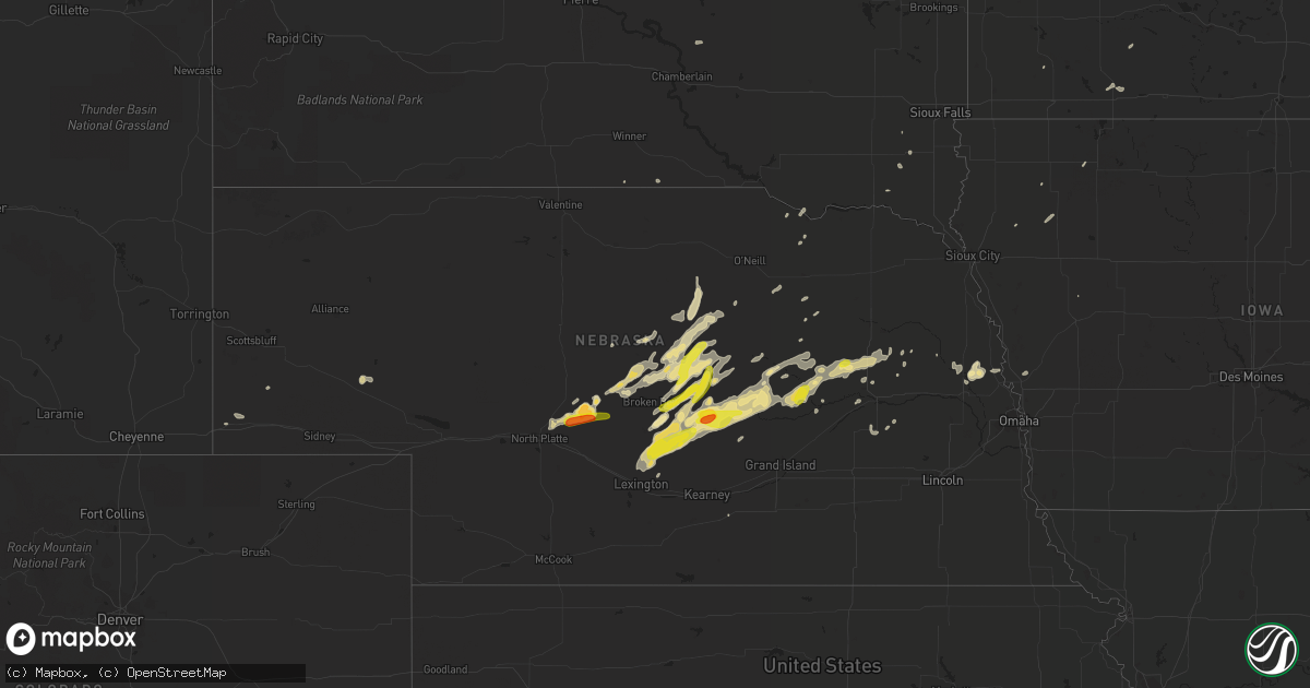
Hail Map in Nebraska on April 14, 2017
Get this storm
April 14 map
$229
one time, instant access
Download today. No call, no setup
Keep the $229
Bought the map and want the full workflow? Apply the entire $229 to a subscription within 7 days. None of it is wasted.
Every map, not just this one
This buys you this map. Subscription and you get every map we run, in the markets you choose from a few cities to whole states to nationwide. Plus real-time alerts the moment a storm fires.
Contact data
Name, contact info, occupancy, even credit band for addresses in the footprint. You go from where it hit to who to call.
Become the source they trust
Unlimited branding weather history reports on demand. You already have the documented answer ready for the property owner, and you are the one who showed up with it.
Property data and RoofTrace estimates
Pull up any address you have got, its value and the exact code rules for that jurisdiction, straight from One Click Code. Then RoofTrace estimates the squares, pitch, and roof value, priced the way you price.
Storm reports in Nebraska
Nebraska
| Date | Description |
|---|---|
| 04/14/20172:20 AM CDT | Most stones the size of nickels or smaller... But the observer stated a few stones were as large as a quarter. |
| 04/14/20171:27 AM CDT | Dime to quarter size hail. |
| 04/14/20171:10 AM CDT | A local report indicates 1.75 inch wind near 8 WSW ARNOLD |
| 04/13/201710:46 PM CDT | A local report indicates 1.25 inch wind near 17 NE BROKEN BOW |
| 04/13/201710:45 PM CDT | Most hail was half inch... But a few were as large as quarter size. |
| 04/13/20179:44 PM CDT | A local report indicates 1.25 inch wind near 18 SSE BROKEN BOW |
| 04/13/20179:33 PM CDT | A local report indicates 1.25 inch wind near 2 E SARGENT |
| 04/13/20179:32 PM CDT | Emergency manager reports quarter sized hail 3-4 miles south of loup city. |
| 04/13/20179:12 PM CDT | Hail lasted off and on for about an hour. Mostly quarter sized hail ended at 9:12 pm with a few larger stones. No wind. |
| 04/13/20179:05 PM CDT | Nerain observer reported hail up to quarter size |
| 04/13/20179:03 PM CDT | Hail lasted for 6 minutes and peaked at half dollar size. |
| 04/13/20179:03 PM CDT | A local report indicates 1.00 inch wind near 7 W BURWELL |
| 04/13/20178:50 PM CDT | Mostly quarter sized hail with a few larger stones at the onset of hail. |
| 04/13/20178:26 PM CDT | A local report indicates 1.00 inch wind near KIMBALL |
| 04/13/20177:53 PM CDT | Emergency manager reports quarter to half dollar size hail in town. |
| 04/13/20177:48 PM CDT | A local report indicates 1.25 inch wind near 8 WNW LOUP CITY |
| 04/13/20177:45 PM CDT | Photo received via twitter after hail had fallen. Time estimated from radar. |
| 04/13/20177:10 PM CDT | Hail up to quarter size fell for around 10 minutes starting around 7pm. |
All States Impacted by Hail Map on April 14, 2017
Cities Impacted by Hail Map on April 14, 2017
- Arlington, NE
- Nickerson, NE
- Herman, NE
- Hooper, NE
- Fort Stockton, TX
- Greeley, NE
- Spalding, NE
- North Platte, NE
- Amelia, NE
- Burwell, NE
- Tulia, TX
- Boelus, NE
- Rockville, NE
- Pecos, TX
- Balmorhea, TX
- Humphrey, NE
- Lindsay, NE
- Dimmitt, TX
- Hereford, TX
- Monahans, TX
- Faulkton, SD
- Ansley, NE
- Albion, NE
- Farwell, TX
- Friona, TX
- Bovina, TX
- Childress, TX
- Mason City, NE
- Sumner, NE
- Eddyville, NE
- Broken Bow, NE
- Oconto, NE
- Loup City, NE
- Arcadia, NE
- Westerville, NE
- Elyria, NE
- Ord, NE
- Comstock, NE
- Litchfield, NE
- Rising City, NE
- Ashton, NE
- Saint Paul, NE
- Scotia, NE
- Wolbach, NE
- Elba, NE
- North Loup, NE
- Lockney, TX
- Arnold, NE
- Plainview, TX
- Imperial, TX
- Belgrade, NE
- Fullerton, NE
- Cedar Rapids, NE
- Palmer, NE
- Saint Edward, NE
- Brady, NE
- Kress, TX
- Hart, TX
- Nazareth, TX
- Roscoe, SD
- Amarillo, TX
- Parker, SD
- Leigh, NE
- Platte Center, NE
- Columbus, NE
- Callaway, NE
- Maxwell, NE
- Kiron, IA
- Sargent, NE
- Anselmo, NE
- Taylor, NE
- Memphis, TX
- Gothenburg, NE
- Stapleton, NE
- Turkey, TX
- Milford, IL
- Scribner, NE
- Lisco, NE
- Lakeview, TX
- Clarendon, TX
- Ewing, NE
- Blair, NE
- Happy, TX
- Summerfield, TX
- Olton, TX
- Quitaque, TX
- Shelby, NE
- Merna, NE
- Everly, IA
- Dunning, NE
- Wildorado, TX
- Masterson, TX
- Vega, TX
- Brewster, NE
- Chambers, NE
- Craig, NE
- Verdigre, NE
- Alvin, IL
- Henning, IL
- Astoria, IL
- Remsen, IA
- Jackson, MN
- Alpha, MN
- Oakdale, NE
- Wellington, IL
- Creston, NE
- Madison, NE
- Newman Grove, NE
- Clarkson, NE
- Meriden, IA
- Cherokee, IA
- Miller, NE
- Farwell, NE
- Lexington, NE
- Primrose, NE
- Ericson, NE
- Stanton, NE
- Darfur, MN
- Butterfield, MN
- Kermit, TX
- Viborg, SD
- Howells, NE
- Gregory, SD
- Dallas, SD
- Hedley, TX
- Overton, NE
- Harrisburg, NE
- Atkinson, NE
- Stuart, NE
- Genoa, NE
- Clearwater, NE
- Missouri Valley, IA
- Volin, SD
- David City, NE
- Clovis, NM
- West Point, NE
- Kimball, NE
- Bushnell, NE
- Neligh, NE
- Fulda, MN
- Niobrara, NE
- Petersburg, NE
- Ipava, IL
- Paullina, IA
- Minden, NE
- Winner, SD
- Hurley, SD
- Davis, SD
- Monroe, NE
- Springfield, SD
- Fort Thompson, SD


