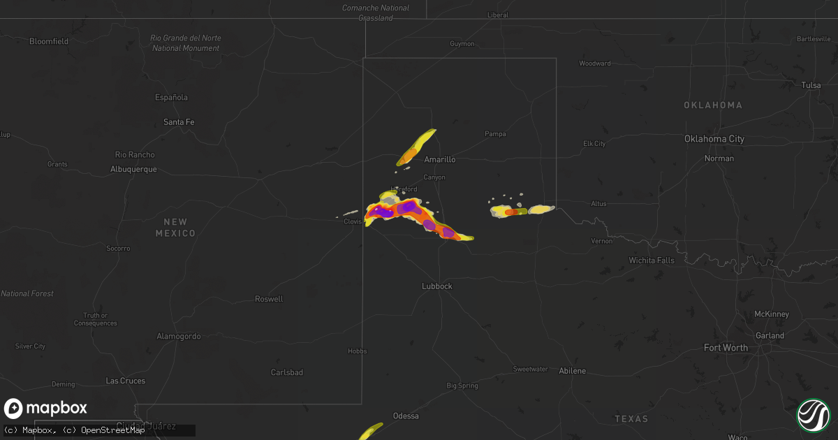
Hail Map on April 14, 2017
Get this storm
April 14 map
$229
one time, instant access
Download today. No call, no setup
Keep the $229
Bought the map and want the full workflow? Apply the entire $229 to a subscription within 7 days. None of it is wasted.
Every map, not just this one
This buys you this map. Subscription and you get every map we run, in the markets you choose from a few cities to whole states to nationwide. Plus real-time alerts the moment a storm fires.
Contact data
Name, contact info, occupancy, even credit band for addresses in the footprint. You go from where it hit to who to call.
Become the source they trust
Unlimited branding weather history reports on demand. You already have the documented answer ready for the property owner, and you are the one who showed up with it.
Property data and RoofTrace estimates
Pull up any address you have got, its value and the exact code rules for that jurisdiction, straight from One Click Code. Then RoofTrace estimates the squares, pitch, and roof value, priced the way you price.
States Impacted by Hail Map on April 14, 2017
Storm reports
Oklahoma
| Date | Description |
|---|---|
| 04/14/20173:05 AM CDT | A local report indicates 58 MPH wind near 3 W GOULD |
Texas
| Date | Description |
|---|---|
| 04/14/20176:56 PM CDT | 8-10 power poles snapped off... Possibly from an earlier tornado. Time of damage is estimated. |
| 04/14/20176:56 PM CDT | Video of a large tornado ongoing about 3 miles west of dimmitt. One of many tornadoes over the past 20 minutes with this storm. |
| 04/14/20176:42 PM CDT | Several tornado touchdowns starting at 637 pm and continuing through the time of report. Power lines down. |
| 04/14/20176:30 PM CDT | Powerpoles down on fm 1524 |
| 04/14/20176:27 PM CDT | Multivortex tornado observed on live spotter feed. |
| 04/14/20176:07 PM CDT | Heavy amounts of quarter sized hail two miles south of highway 285 on mendel road. |
| 04/14/20176:05 PM CDT | Tornado observed by storm spotter |
| 04/14/20175:36 PM CDT | A local report indicates 1.00 inch wind near 24 WNW FORT STOCKTON |
| 04/14/20175:32 PM CDT | Time of hail estimated. |
| 04/14/20175:14 PM CDT | Hail destroyed the windshield. |
| 04/14/20175:07 PM CDT | A local report indicates 1.77 inch wind near 8 S FRIONA |
| 04/14/20175:07 PM CDT | Hail knock out the windshield of the police car. Time of hail is estimated. |
| 04/14/20175:02 PM CDT | A local report indicates 2.25 inch wind near 3 ENE BOVINA |
| 04/14/20174:57 PM CDT | A local report indicates 1.88 inch wind near 4 ENE BOVINA |
| 04/14/20174:54 PM CDT | A local report indicates 1.00 inch wind near 4 ENE BOVINA |
| 04/14/20174:26 PM CDT | A local report indicates 1.85 inch wind near 1 ENE BOVINA |
| 04/14/20174:14 PM CDT | A local report indicates 1.50 inch wind near 2 SW BOVINA |
| 04/14/201712:34 AM CDT | A local report indicates 1.50 inch wind near PLAINVIEW |
| 04/14/201712:12 AM CDT | A local report indicates 1.75 inch wind near 1 W PLAINVIEW |
| 04/13/201711:25 PM CDT | A local report indicates a tornado near 1 NE EDMONSON |
| 04/13/201710:55 PM CDT | Measured by the texas tech mesonet. The 1050 pm observation has a wind gust to 77 mph. |
| 04/13/201710:35 PM CDT | A local report indicates 1.00 inch wind near HART |
| 04/13/20179:55 PM CDT | A local report indicates 1.75 inch wind near NAZARETH |
| 04/13/20179:25 PM CDT | A local report indicates 2.75 inch wind near 1 N DIMMITT |
| 04/13/20179:20 PM CDT | A local report indicates 2.80 inch wind near 1 N DIMMITT |
| 04/13/20178:39 PM CDT | Nickel to quarter size hail falling in dimmitt currently. |
| 04/13/20178:16 PM CDT | Power pole snapped about 10 feet above the ground. The time of damage is unknown. |
| 04/13/20178:04 PM CDT | Brief rope tornado noted in chaser video feed. |
| 04/13/20177:50 PM CDT | West texas mesonet measured a southerly inflow wind gust to 60 mph. |
| 04/13/20177:47 PM CDT | Brief tornado observed by storm spotter. Location estimated by radar. |
| 04/13/20177:28 PM CDT | Golfball sized hail covering i-10 at milemarker 246 west of fort stockton. |
| 04/13/20177:13 PM CDT | There were several vehicles with broken windshields along i-10 from 12 to 23 miles west of fort stockton lasting from 713 to 747. |
| 04/13/20177:10 PM CDT | A local report indicates 2.00 inch wind near 24 WNW FORT STOCKTON |
Nebraska
| Date | Description |
|---|---|
| 04/14/20172:20 AM CDT | Most stones the size of nickels or smaller... But the observer stated a few stones were as large as a quarter. |
| 04/14/20171:27 AM CDT | Dime to quarter size hail. |
| 04/14/20171:10 AM CDT | A local report indicates 1.75 inch wind near 8 WSW ARNOLD |
| 04/13/201710:46 PM CDT | A local report indicates 1.25 inch wind near 17 NE BROKEN BOW |
| 04/13/201710:45 PM CDT | Most hail was half inch... But a few were as large as quarter size. |
| 04/13/20179:44 PM CDT | A local report indicates 1.25 inch wind near 18 SSE BROKEN BOW |
| 04/13/20179:33 PM CDT | A local report indicates 1.25 inch wind near 2 E SARGENT |
| 04/13/20179:32 PM CDT | Emergency manager reports quarter sized hail 3-4 miles south of loup city. |
| 04/13/20179:12 PM CDT | Hail lasted off and on for about an hour. Mostly quarter sized hail ended at 9:12 pm with a few larger stones. No wind. |
| 04/13/20179:05 PM CDT | Nerain observer reported hail up to quarter size |
| 04/13/20179:03 PM CDT | Hail lasted for 6 minutes and peaked at half dollar size. |
| 04/13/20179:03 PM CDT | A local report indicates 1.00 inch wind near 7 W BURWELL |
| 04/13/20178:50 PM CDT | Mostly quarter sized hail with a few larger stones at the onset of hail. |
| 04/13/20178:26 PM CDT | A local report indicates 1.00 inch wind near KIMBALL |
| 04/13/20177:53 PM CDT | Emergency manager reports quarter to half dollar size hail in town. |
| 04/13/20177:48 PM CDT | A local report indicates 1.25 inch wind near 8 WNW LOUP CITY |
| 04/13/20177:45 PM CDT | Photo received via twitter after hail had fallen. Time estimated from radar. |
| 04/13/20177:10 PM CDT | Hail up to quarter size fell for around 10 minutes starting around 7pm. |
Cities Impacted by Hail Map on April 14, 2017
- Arlington, NE
- Nickerson, NE
- Herman, NE
- Hooper, NE
- Fort Stockton, TX
- Greeley, NE
- Spalding, NE
- North Platte, NE
- Amelia, NE
- Burwell, NE
- Tulia, TX
- Boelus, NE
- Rockville, NE
- Pecos, TX
- Balmorhea, TX
- Humphrey, NE
- Lindsay, NE
- Dimmitt, TX
- Hereford, TX
- Monahans, TX
- Faulkton, SD
- Ansley, NE
- Albion, NE
- Farwell, TX
- Friona, TX
- Bovina, TX
- Childress, TX
- Mason City, NE
- Sumner, NE
- Eddyville, NE
- Broken Bow, NE
- Oconto, NE
- Loup City, NE
- Arcadia, NE
- Westerville, NE
- Elyria, NE
- Ord, NE
- Comstock, NE
- Litchfield, NE
- Rising City, NE
- Ashton, NE
- Saint Paul, NE
- Scotia, NE
- Wolbach, NE
- Elba, NE
- North Loup, NE
- Lockney, TX
- Arnold, NE
- Plainview, TX
- Imperial, TX
- Belgrade, NE
- Fullerton, NE
- Cedar Rapids, NE
- Palmer, NE
- Saint Edward, NE
- Brady, NE
- Kress, TX
- Hart, TX
- Nazareth, TX
- Roscoe, SD
- Amarillo, TX
- Parker, SD
- Leigh, NE
- Platte Center, NE
- Columbus, NE
- Callaway, NE
- Maxwell, NE
- Kiron, IA
- Sargent, NE
- Anselmo, NE
- Taylor, NE
- Memphis, TX
- Gothenburg, NE
- Stapleton, NE
- Turkey, TX
- Milford, IL
- Scribner, NE
- Lisco, NE
- Lakeview, TX
- Clarendon, TX
- Ewing, NE
- Blair, NE
- Happy, TX
- Summerfield, TX
- Olton, TX
- Quitaque, TX
- Shelby, NE
- Merna, NE
- Everly, IA
- Dunning, NE
- Wildorado, TX
- Masterson, TX
- Vega, TX
- Brewster, NE
- Chambers, NE
- Craig, NE
- Verdigre, NE
- Alvin, IL
- Henning, IL
- Astoria, IL
- Remsen, IA
- Jackson, MN
- Alpha, MN
- Oakdale, NE
- Wellington, IL
- Creston, NE
- Madison, NE
- Newman Grove, NE
- Clarkson, NE
- Meriden, IA
- Cherokee, IA
- Miller, NE
- Farwell, NE
- Lexington, NE
- Primrose, NE
- Ericson, NE
- Stanton, NE
- Darfur, MN
- Butterfield, MN
- Kermit, TX
- Viborg, SD
- Howells, NE
- Gregory, SD
- Dallas, SD
- Hedley, TX
- Overton, NE
- Harrisburg, NE
- Atkinson, NE
- Stuart, NE
- Genoa, NE
- Clearwater, NE
- Missouri Valley, IA
- Volin, SD
- David City, NE
- Clovis, NM
- West Point, NE
- Kimball, NE
- Bushnell, NE
- Neligh, NE
- Fulda, MN
- Niobrara, NE
- Petersburg, NE
- Ipava, IL
- Paullina, IA
- Minden, NE
- Winner, SD
- Hurley, SD
- Davis, SD
- Monroe, NE
- Springfield, SD
- Fort Thompson, SD