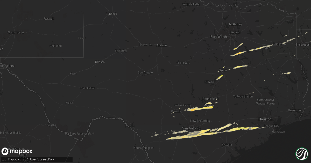
Hail Map in Texas on April 14, 2014
Get this storm
April 14 map
$229
one time, instant access
Download today. No call, no setup
Keep the $229
Bought the map and want the full workflow? Apply the entire $229 to a subscription within 7 days. None of it is wasted.
Every map, not just this one
This buys you this map. Subscription and you get every map we run, in the markets you choose from a few cities to whole states to nationwide. Plus real-time alerts the moment a storm fires.
Contact data
Name, contact info, occupancy, even credit band for addresses in the footprint. You go from where it hit to who to call.
Become the source they trust
Unlimited branding weather history reports on demand. You already have the documented answer ready for the property owner, and you are the one who showed up with it.
Property data and RoofTrace estimates
Pull up any address you have got, its value and the exact code rules for that jurisdiction, straight from One Click Code. Then RoofTrace estimates the squares, pitch, and roof value, priced the way you price.
Storm reports in Texas
Texas
| Date | Description |
|---|---|
| 04/14/20141:19 PM CDT | Half dollar size hail. Time estimated via radar. |
| 04/14/201412:50 PM CDT | A local report indicates 1.00 inch wind near 4 NE POTEET |
| 04/14/201412:45 PM CDT | A local report indicates 1.00 inch wind near 6 N POTEET |
| 04/14/201412:26 PM CDT | A local report indicates 1.50 inch wind near 5 E BIG FOOT |
| 04/14/201412:25 PM CDT | A local report indicates 1.00 inch wind near SHINER |
| 04/14/201412:10 PM CDT | A local report indicates 1.25 inch wind near 4 WNW HALLETTSVILLE |
| 04/14/201411:55 AM CDT | A local report indicates 1.00 inch wind near SHINER |
| 04/14/201411:11 AM CDT | A local report indicates 1.75 inch wind near 4 N STOCKDALE |
| 04/14/201411:05 AM CDT | A local report indicates 1.25 inch wind near GARFIELD |
| 04/14/201411:00 AM CDT | A local report indicates 1.25 inch wind near 1 E AUSTIN BERGSTROM IN |
| 04/14/201410:58 AM CDT | Nickel to quarter sized hail |
| 04/14/201410:56 AM CDT | A local report indicates 1.75 inch wind near 2 N STOCKDALE |
| 04/14/201410:54 AM CDT | Golf ball sized hail near del valle |
| 04/14/201410:51 AM CDT | Near austin community college |
| 04/14/201410:44 AM CDT | A local report indicates 1.00 inch wind near 2 SSE SUNSET VALLEY |
| 04/14/201410:40 AM CDT | Report relayed by limestone county sheriffs office. Spotters reported dime to quarter size hail in mexia. |
| 04/14/201410:35 AM CDT | Nickel to quarter size hail fell in the new harmony community |
| 04/14/201410:30 AM CDT | Cocorahs observer reported quarter size hail. Time estimated via radar. |
| 04/14/201410:21 AM CDT | Large tree blown down |
| 04/14/20149:57 AM CDT | Near chalk bluff |
| 04/14/20149:38 AM CDT | A local report indicates 1.75 inch wind near BLANCO |
| 04/14/20149:13 AM CDT | Quarter to golf ball hail covering the roadway i-45 at north business bypass |
| 04/14/20149:02 AM CDT | Along fm 3383 |
| 04/14/20148:59 AM CDT | A local report indicates 2.00 inch wind near 1 N CORSICANA |
| 04/14/20148:26 AM CDT | A local report indicates 1.50 inch wind near 7 E BLANCO |
| 04/14/20147:00 AM CDT | Trained storm spotter reported wind gusts of 60mph east side of grapeland. |
Cities Impacted by Hail Map on April 14, 2014
- Winnsboro, LA
- Columbia, LA
- Grayson, LA
- Olla, LA
- Kelly, LA
- Jefferson, TX
- Stockdale, TX
- Atascosa, TX
- Lytle, TX
- Devine, TX
- Castroville, TX
- La Coste, TX
- Natalia, TX
- Corsicana, TX
- Barry, TX
- Powell, TX
- Havana, FL
- Troy, TX
- San Antonio, TX
- Cuero, TX
- Floresville, TX
- Gillett, TX
- Smiley, TX
- Westhoff, TX
- Nixon, TX
- Ennis, TX
- Blanco, TX
- Bigfoot, TX
- Elmendorf, TX
- Pearsall, TX
- Batesville, TX
- Yancey, TX
- La Vernia, TX
- Pleasanton, TX
- Somerset, TX
- Sutherland Springs, TX
- Poteet, TX
- Moore, TX
- Gonzales, TX
- Von Ormy, TX
- Frost, TX
- Rice, TX
- Kerens, TX
- Blooming Grove, TX
- Kaplan, LA
- Beasley, TX
- Richmond, TX
- Needville, TX
- Hallettsville, TX
- Garwood, TX
- Kennard, TX
- Brownsboro, TX
- Murchison, TX
- Dripping Springs, TX
- Wimberley, TX
- Shiner, TX
- Boerne, TX
- Hallsville, TX
- Driftwood, TX
- Austin, TX
- Sheridan, TX
- Weimar, TX
- Adkins, TX
- Schulenburg, TX
- Tyler, TX
- Yoakum, TX
- Lufkin, TX
- Downsville, LA
- Choudrant, LA
- Calhoun, LA
- West Monroe, LA
- Ruston, LA
- Kaufman, TX
- Scurry, TX
- Winona, TX
- Marshall, TX
- Longview, TX
- Iola, TX
- Bedias, TX
- Malakoff, TX
- Athens, TX
- Eustace, TX
- Temple, TX
- Lorena, TX
- Eddy, TX
- Bruceville, TX
- Moody, TX
- Carthage, TX
- Dubach, LA
- Chireno, TX
- Eglin Afb, FL
- Shalimar, FL
- Fort Walton Beach, FL
- Elm Mott, TX
- Waco, TX
- Buda, TX
- Del Valle, TX
- Kendalia, TX
- Manchaca, TX
- Monroe, LA
- Oil City, LA
- San Augustine, TX
- Plain Dealing, LA
- Glen Flora, TX
- East Bernard, TX
- El Campo, TX
- Wharton, TX
- Eagle Lake, TX
- Rosenberg, TX
- Lovelady, TX
- Moulton, TX
- Pierre Part, LA
- Sabinal, TX
- Arcadia, LA
- Gibsland, LA
- Medina, TX
- Wrightsboro, TX
- Karnack, TX
- Jeanerette, LA
- D Hanis, TX
- Groesbeck, TX
- Prairie Hill, TX
- Teague, TX
- Fairfield, TX
- Mexia, TX
- Chandler, TX
- Ben Wheeler, TX
- Hye, TX
- Johnson City, TX
- Stonewall, TX
- Manvel, TX
- Columbus, TX
- Franklin, LA
- Morgan City, LA
- Baldwin, LA
- Mabank, TX
- Hondo, TX
- Uvalde, TX
- Orange, TX
- Kerrville, TX
- Thomasville, GA
- Fredericksburg, TX
- Kilgore, TX
- Cost, TX
- Brackettville, TX
- Wewahitchka, FL
- Sibley, LA
- Minden, LA
- Taylor, TX
- Coupland, TX
- Athens, LA
- Simsboro, LA
- Mart, TX
- Riesel, TX
- Kemp, TX
- Quincy, FL
- Climax, GA
- Attapulgus, GA
- Whigham, GA
- Tallahassee, FL
- Cairo, GA
- Livingston, LA
- Rosharon, TX
- Gladewater, TX
- Elgin, TX
- Woodway, TX
- McGregor, TX
- Nacogdoches, TX
- Pollock, LA
- Sterlington, LA


