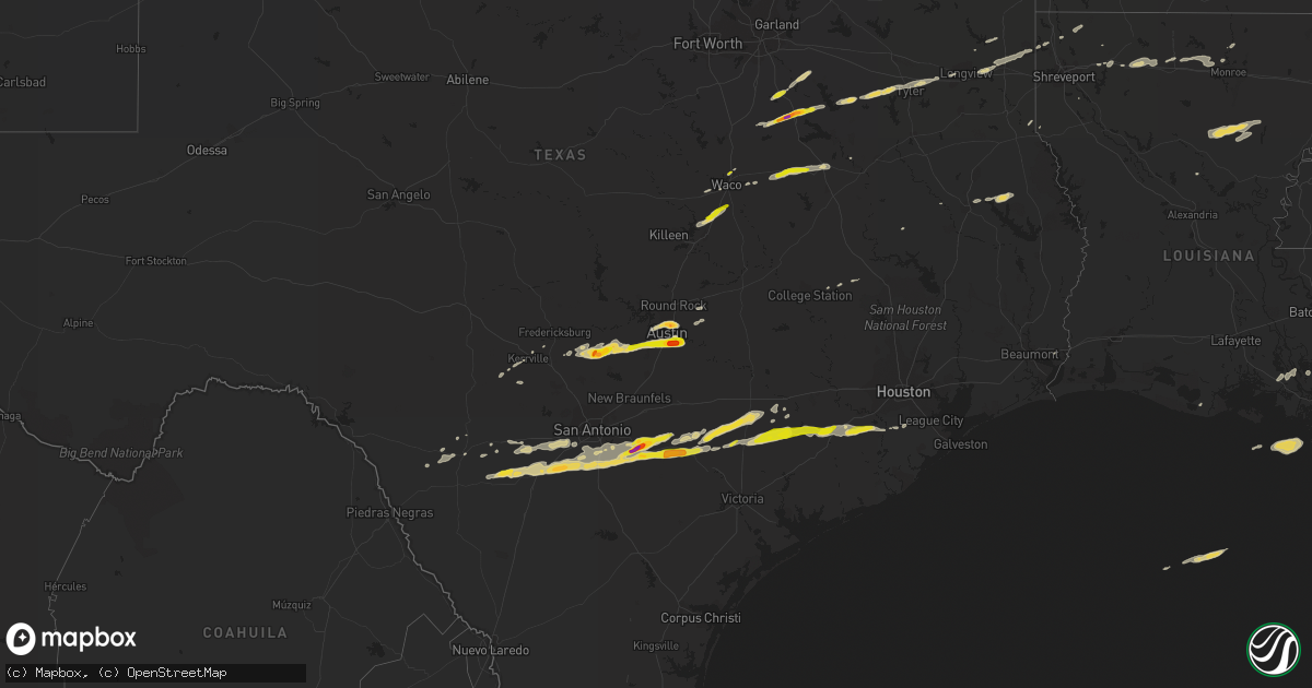
Hail Map on April 14, 2014
Get this storm
April 14 map
$229
one time, instant access
Download today. No call, no setup
Keep the $229
Bought the map and want the full workflow? Apply the entire $229 to a subscription within 7 days. None of it is wasted.
Every map, not just this one
This buys you this map. Subscription and you get every map we run, in the markets you choose from a few cities to whole states to nationwide. Plus real-time alerts the moment a storm fires.
Contact data
Name, contact info, occupancy, even credit band for addresses in the footprint. You go from where it hit to who to call.
Become the source they trust
Unlimited branding weather history reports on demand. You already have the documented answer ready for the property owner, and you are the one who showed up with it.
Property data and RoofTrace estimates
Pull up any address you have got, its value and the exact code rules for that jurisdiction, straight from One Click Code. Then RoofTrace estimates the squares, pitch, and roof value, priced the way you price.
Storm reports
Mississippi
| Date | Description |
|---|---|
| 04/14/20145:48 PM CDT | A tree was downed at lawrence rd and taylor ln |
| 04/14/20145:31 PM CDT | Several trees down along interstate 55 between goodman and pickens. |
| 04/14/20145:31 PM CDT | A couple trees down around canton. |
| 04/14/20145:30 PM CDT | Large trees down on east ridge and northside drives |
| 04/14/20145:29 PM CDT | Traffic light damaged along fortification street |
| 04/14/20145:26 PM CDT | Several trees down along highway 17 northwest of pickens |
| 04/14/20145:20 PM CDT | Several trees downed on the east side of clinton |
| 04/14/20145:20 PM CDT | A tree was downed blocking ms highway 16 |
| 04/14/20145:10 PM CDT | Reports of trees down at higgins road and scotland road. |
| 04/14/20144:55 PM CDT | Reports of trees down at higgins road and scotland road. |
| 04/14/20144:50 PM CDT | Reports of trees down on highway 433 and highway 3 near satartia. |
| 04/14/20144:40 PM CDT | Reports of trees and powerlines down in campbell swamp. |
| 04/14/20144:40 PM CDT | Reports of multiple trees and powerlines down across the county. A tree and powerline fell on a vehicle on jeff davis road. No injuries but driver is trapped. |
| 04/14/20144:24 PM CDT | Reports of damage to a boathouse at eagle lake. |
| 04/14/20144:18 PM CDT | Reports of damage to a boathouse at eagle lake. Time confirmed from emergency manager. |
| 04/14/20144:15 PM CDT | Reports of damage to a boathouse at eagle lake. |
| 04/14/20141:20 PM CDT | Multiple large limbs broken out of trees. |
| 04/13/20147:50 PM CDT | *** 2 inj *** surveyors have determined that straight-line winds estimated between 75-80 mph struck the santa rosa rv resort marina at 5800 moss bluff road. 20 rv trail |
Louisiana
| Date | Description |
|---|---|
| 04/14/20144:05 PM CDT | A few trees were down. A funnel cloud was reported in the area as well. |
| 04/14/20143:03 PM CDT | A tree fell on a boat and two four wheelers and a shed roof was blown off at jackson lane near chase. |
| 04/14/20143:03 PM CDT | Report of multiple trees down on roads in gilbert. |
| 04/14/20142:50 PM CDT | Tree down on fairview street near byrd high school |
| 04/14/20142:38 PM CDT | A few trees down |
| 04/14/20141:45 PM CDT | Tree down on fairfield street |
| 04/14/201412:40 PM CDT | Power lines down |
| 04/14/201412:37 PM CDT | Tree down |
| 04/14/201412:25 PM CDT | Part of a metal roof was damaged on a barn. |
| 04/14/201411:55 AM CDT | Trees down on standard reed road and holley lane |
| 04/14/201411:40 AM CDT | A few trees down. Trees on a house. Shed blown away. Corner of good hoe and 40 oaks. |
| 04/14/201411:10 AM CDT | Trees down near choudrant and down east part of lincoln parish... Hail reported no size |
| 04/14/201410:49 AM CDT | Tree down in shiloh... Near bryceland... Pea size hail also |
Alabama
| Date | Description |
|---|---|
| 04/13/20147:45 PM CDT | Tree down on an apartment. |
Florida
| Date | Description |
|---|---|
| 04/14/20143:15 AM CDT | Pine tree snapped and shed damaged |
Texas
| Date | Description |
|---|---|
| 04/14/20141:19 PM CDT | Half dollar size hail. Time estimated via radar. |
| 04/14/201412:50 PM CDT | A local report indicates 1.00 inch wind near 4 NE POTEET |
| 04/14/201412:45 PM CDT | A local report indicates 1.00 inch wind near 6 N POTEET |
| 04/14/201412:26 PM CDT | A local report indicates 1.50 inch wind near 5 E BIG FOOT |
| 04/14/201412:25 PM CDT | A local report indicates 1.00 inch wind near SHINER |
| 04/14/201412:10 PM CDT | A local report indicates 1.25 inch wind near 4 WNW HALLETTSVILLE |
| 04/14/201411:55 AM CDT | A local report indicates 1.00 inch wind near SHINER |
| 04/14/201411:11 AM CDT | A local report indicates 1.75 inch wind near 4 N STOCKDALE |
| 04/14/201411:05 AM CDT | A local report indicates 1.25 inch wind near GARFIELD |
| 04/14/201411:00 AM CDT | A local report indicates 1.25 inch wind near 1 E AUSTIN BERGSTROM IN |
| 04/14/201410:58 AM CDT | Nickel to quarter sized hail |
| 04/14/201410:56 AM CDT | A local report indicates 1.75 inch wind near 2 N STOCKDALE |
| 04/14/201410:54 AM CDT | Golf ball sized hail near del valle |
| 04/14/201410:51 AM CDT | Near austin community college |
| 04/14/201410:44 AM CDT | A local report indicates 1.00 inch wind near 2 SSE SUNSET VALLEY |
| 04/14/201410:40 AM CDT | Report relayed by limestone county sheriffs office. Spotters reported dime to quarter size hail in mexia. |
| 04/14/201410:35 AM CDT | Nickel to quarter size hail fell in the new harmony community |
| 04/14/201410:30 AM CDT | Cocorahs observer reported quarter size hail. Time estimated via radar. |
| 04/14/201410:21 AM CDT | Large tree blown down |
| 04/14/20149:57 AM CDT | Near chalk bluff |
| 04/14/20149:38 AM CDT | A local report indicates 1.75 inch wind near BLANCO |
| 04/14/20149:13 AM CDT | Quarter to golf ball hail covering the roadway i-45 at north business bypass |
| 04/14/20149:02 AM CDT | Along fm 3383 |
| 04/14/20148:59 AM CDT | A local report indicates 2.00 inch wind near 1 N CORSICANA |
| 04/14/20148:26 AM CDT | A local report indicates 1.50 inch wind near 7 E BLANCO |
| 04/14/20147:00 AM CDT | Trained storm spotter reported wind gusts of 60mph east side of grapeland. |
North Carolina
| Date | Description |
|---|---|
| 04/14/20146:25 AM CDT | Multiple trees snapped...some damage to a car...and minor damage to two homes on royal williams road. Nws survey team will meet property owner wed morning to investigat |
| 04/13/201411:10 PM CDT | Cti gust to 62 mph |
Cities Impacted by Hail Map on April 14, 2014
- Winnsboro, LA
- Columbia, LA
- Grayson, LA
- Olla, LA
- Kelly, LA
- Jefferson, TX
- Stockdale, TX
- Atascosa, TX
- Lytle, TX
- Devine, TX
- Castroville, TX
- La Coste, TX
- Natalia, TX
- Corsicana, TX
- Barry, TX
- Powell, TX
- Havana, FL
- Troy, TX
- San Antonio, TX
- Cuero, TX
- Floresville, TX
- Gillett, TX
- Smiley, TX
- Westhoff, TX
- Nixon, TX
- Ennis, TX
- Blanco, TX
- Bigfoot, TX
- Elmendorf, TX
- Pearsall, TX
- Batesville, TX
- Yancey, TX
- La Vernia, TX
- Pleasanton, TX
- Somerset, TX
- Sutherland Springs, TX
- Poteet, TX
- Moore, TX
- Gonzales, TX
- Von Ormy, TX
- Frost, TX
- Rice, TX
- Kerens, TX
- Blooming Grove, TX
- Kaplan, LA
- Beasley, TX
- Richmond, TX
- Needville, TX
- Hallettsville, TX
- Garwood, TX
- Kennard, TX
- Brownsboro, TX
- Murchison, TX
- Dripping Springs, TX
- Wimberley, TX
- Shiner, TX
- Boerne, TX
- Hallsville, TX
- Driftwood, TX
- Austin, TX
- Sheridan, TX
- Weimar, TX
- Adkins, TX
- Schulenburg, TX
- Tyler, TX
- Yoakum, TX
- Lufkin, TX
- Downsville, LA
- Choudrant, LA
- Calhoun, LA
- West Monroe, LA
- Ruston, LA
- Kaufman, TX
- Scurry, TX
- Winona, TX
- Marshall, TX
- Longview, TX
- Iola, TX
- Bedias, TX
- Malakoff, TX
- Athens, TX
- Eustace, TX
- Temple, TX
- Lorena, TX
- Eddy, TX
- Bruceville, TX
- Moody, TX
- Carthage, TX
- Dubach, LA
- Chireno, TX
- Eglin Afb, FL
- Shalimar, FL
- Fort Walton Beach, FL
- Elm Mott, TX
- Waco, TX
- Buda, TX
- Del Valle, TX
- Kendalia, TX
- Manchaca, TX
- Monroe, LA
- Oil City, LA
- San Augustine, TX
- Plain Dealing, LA
- Glen Flora, TX
- East Bernard, TX
- El Campo, TX
- Wharton, TX
- Eagle Lake, TX
- Rosenberg, TX
- Lovelady, TX
- Moulton, TX
- Pierre Part, LA
- Sabinal, TX
- Arcadia, LA
- Gibsland, LA
- Medina, TX
- Wrightsboro, TX
- Karnack, TX
- Jeanerette, LA
- D Hanis, TX
- Groesbeck, TX
- Prairie Hill, TX
- Teague, TX
- Fairfield, TX
- Mexia, TX
- Chandler, TX
- Ben Wheeler, TX
- Hye, TX
- Johnson City, TX
- Stonewall, TX
- Manvel, TX
- Columbus, TX
- Franklin, LA
- Morgan City, LA
- Baldwin, LA
- Mabank, TX
- Hondo, TX
- Uvalde, TX
- Orange, TX
- Kerrville, TX
- Thomasville, GA
- Fredericksburg, TX
- Kilgore, TX
- Cost, TX
- Brackettville, TX
- Wewahitchka, FL
- Sibley, LA
- Minden, LA
- Taylor, TX
- Coupland, TX
- Athens, LA
- Simsboro, LA
- Mart, TX
- Riesel, TX
- Kemp, TX
- Quincy, FL
- Climax, GA
- Attapulgus, GA
- Whigham, GA
- Tallahassee, FL
- Cairo, GA
- Livingston, LA
- Rosharon, TX
- Gladewater, TX
- Elgin, TX
- Woodway, TX
- McGregor, TX
- Nacogdoches, TX
- Pollock, LA
- Sterlington, LA