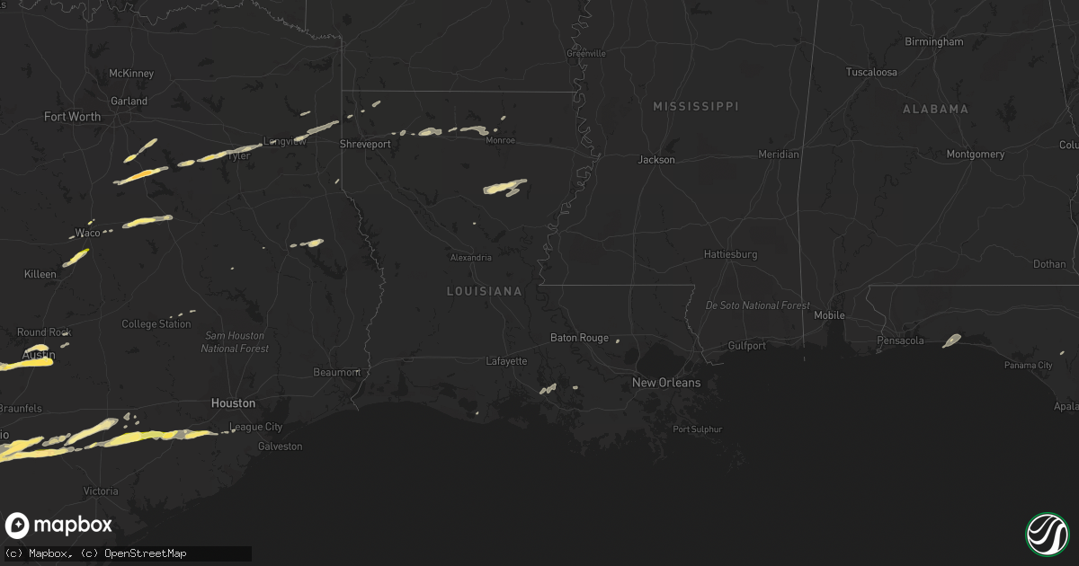
Hail Map in Louisiana on April 14, 2014
Get this storm
April 14 map
$229
one time, instant access
Download today. No call, no setup
Keep the $229
Bought the map and want the full workflow? Apply the entire $229 to a subscription within 7 days. None of it is wasted.
Every map, not just this one
This buys you this map. Subscription and you get every map we run, in the markets you choose from a few cities to whole states to nationwide. Plus real-time alerts the moment a storm fires.
Contact data
Name, contact info, occupancy, even credit band for addresses in the footprint. You go from where it hit to who to call.
Become the source they trust
Unlimited branding weather history reports on demand. You already have the documented answer ready for the property owner, and you are the one who showed up with it.
Property data and RoofTrace estimates
Pull up any address you have got, its value and the exact code rules for that jurisdiction, straight from One Click Code. Then RoofTrace estimates the squares, pitch, and roof value, priced the way you price.
Storm reports in Louisiana
Louisiana
| Date | Description |
|---|---|
| 04/14/20144:05 PM CDT | A few trees were down. A funnel cloud was reported in the area as well. |
| 04/14/20143:03 PM CDT | Report of multiple trees down on roads in gilbert. |
| 04/14/20143:03 PM CDT | A tree fell on a boat and two four wheelers and a shed roof was blown off at jackson lane near chase. |
| 04/14/20142:50 PM CDT | Tree down on fairview street near byrd high school |
| 04/14/20142:38 PM CDT | A few trees down |
| 04/14/20141:45 PM CDT | Tree down on fairfield street |
| 04/14/201412:40 PM CDT | Power lines down |
| 04/14/201412:37 PM CDT | Tree down |
| 04/14/201412:25 PM CDT | Part of a metal roof was damaged on a barn. |
| 04/14/201411:55 AM CDT | Trees down on standard reed road and holley lane |
| 04/14/201411:40 AM CDT | A few trees down. Trees on a house. Shed blown away. Corner of good hoe and 40 oaks. |
| 04/14/201411:10 AM CDT | Trees down near choudrant and down east part of lincoln parish... Hail reported no size |
| 04/14/201410:49 AM CDT | Tree down in shiloh... Near bryceland... Pea size hail also |
Cities Impacted by Hail Map on April 14, 2014
- Winnsboro, LA
- Columbia, LA
- Grayson, LA
- Olla, LA
- Kelly, LA
- Jefferson, TX
- Stockdale, TX
- Atascosa, TX
- Lytle, TX
- Devine, TX
- Castroville, TX
- La Coste, TX
- Natalia, TX
- Corsicana, TX
- Barry, TX
- Powell, TX
- Havana, FL
- Troy, TX
- San Antonio, TX
- Cuero, TX
- Floresville, TX
- Gillett, TX
- Smiley, TX
- Westhoff, TX
- Nixon, TX
- Ennis, TX
- Blanco, TX
- Bigfoot, TX
- Elmendorf, TX
- Pearsall, TX
- Batesville, TX
- Yancey, TX
- La Vernia, TX
- Pleasanton, TX
- Somerset, TX
- Sutherland Springs, TX
- Poteet, TX
- Moore, TX
- Gonzales, TX
- Von Ormy, TX
- Frost, TX
- Rice, TX
- Kerens, TX
- Blooming Grove, TX
- Kaplan, LA
- Beasley, TX
- Richmond, TX
- Needville, TX
- Hallettsville, TX
- Garwood, TX
- Kennard, TX
- Brownsboro, TX
- Murchison, TX
- Dripping Springs, TX
- Wimberley, TX
- Shiner, TX
- Boerne, TX
- Hallsville, TX
- Driftwood, TX
- Austin, TX
- Sheridan, TX
- Weimar, TX
- Adkins, TX
- Schulenburg, TX
- Tyler, TX
- Yoakum, TX
- Lufkin, TX
- Downsville, LA
- Choudrant, LA
- Calhoun, LA
- West Monroe, LA
- Ruston, LA
- Kaufman, TX
- Scurry, TX
- Winona, TX
- Marshall, TX
- Longview, TX
- Iola, TX
- Bedias, TX
- Malakoff, TX
- Athens, TX
- Eustace, TX
- Temple, TX
- Lorena, TX
- Eddy, TX
- Bruceville, TX
- Moody, TX
- Carthage, TX
- Dubach, LA
- Chireno, TX
- Eglin Afb, FL
- Shalimar, FL
- Fort Walton Beach, FL
- Elm Mott, TX
- Waco, TX
- Buda, TX
- Del Valle, TX
- Kendalia, TX
- Manchaca, TX
- Monroe, LA
- Oil City, LA
- San Augustine, TX
- Plain Dealing, LA
- Glen Flora, TX
- East Bernard, TX
- El Campo, TX
- Wharton, TX
- Eagle Lake, TX
- Rosenberg, TX
- Lovelady, TX
- Moulton, TX
- Pierre Part, LA
- Sabinal, TX
- Arcadia, LA
- Gibsland, LA
- Medina, TX
- Wrightsboro, TX
- Karnack, TX
- Jeanerette, LA
- D Hanis, TX
- Groesbeck, TX
- Prairie Hill, TX
- Teague, TX
- Fairfield, TX
- Mexia, TX
- Chandler, TX
- Ben Wheeler, TX
- Hye, TX
- Johnson City, TX
- Stonewall, TX
- Manvel, TX
- Columbus, TX
- Franklin, LA
- Morgan City, LA
- Baldwin, LA
- Mabank, TX
- Hondo, TX
- Uvalde, TX
- Orange, TX
- Kerrville, TX
- Thomasville, GA
- Fredericksburg, TX
- Kilgore, TX
- Cost, TX
- Brackettville, TX
- Wewahitchka, FL
- Sibley, LA
- Minden, LA
- Taylor, TX
- Coupland, TX
- Athens, LA
- Simsboro, LA
- Mart, TX
- Riesel, TX
- Kemp, TX
- Quincy, FL
- Climax, GA
- Attapulgus, GA
- Whigham, GA
- Tallahassee, FL
- Cairo, GA
- Livingston, LA
- Rosharon, TX
- Gladewater, TX
- Elgin, TX
- Woodway, TX
- McGregor, TX
- Nacogdoches, TX
- Pollock, LA
- Sterlington, LA


