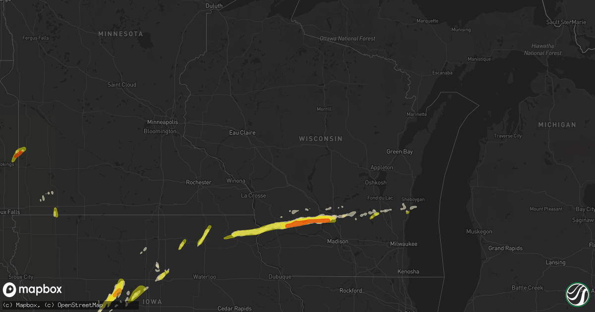
Hail Map in Wisconsin on April 13, 2018
Get this storm
April 13 map
$229
one time, instant access
Download today. No call, no setup
Keep the $229
Bought the map and want the full workflow? Apply the entire $229 to a subscription within 7 days. None of it is wasted.
Every map, not just this one
This buys you this map. Subscription and you get every map we run, in the markets you choose from a few cities to whole states to nationwide. Plus real-time alerts the moment a storm fires.
Contact data
Name, contact info, occupancy, even credit band for addresses in the footprint. You go from where it hit to who to call.
Become the source they trust
Unlimited branding weather history reports on demand. You already have the documented answer ready for the property owner, and you are the one who showed up with it.
Property data and RoofTrace estimates
Pull up any address you have got, its value and the exact code rules for that jurisdiction, straight from One Click Code. Then RoofTrace estimates the squares, pitch, and roof value, priced the way you price.
Storm reports in Wisconsin
Wisconsin
| Date | Description |
|---|---|
| 04/13/20189:55 AM CDT | A local report indicates 1.00 inch wind near MAYVILLE |
| 04/13/20189:43 AM CDT | Quarter sized hail for 2 minutes... Then pea sized for an additional 5 minutes. |
| 04/13/20188:56 AM CDT | Devil's head ski resort. |
| 04/13/20188:52 AM CDT | A local report indicates 1.75 inch wind near 4 S BARABOO |
| 04/13/20188:51 AM CDT | A local report indicates 1.00 inch wind near BARABOO |
| 04/13/20188:50 AM CDT | Via twitter. |
| 04/13/20188:45 AM CDT | A local report indicates 1.25 inch wind near NORTH FREEDOM |
| 04/13/20188:34 AM CDT | Ground is completely white. |
| 04/13/20188:30 AM CDT | A local report indicates 1.25 inch wind near RICHLAND CENTER |
| 04/13/20188:19 AM CDT | Started off as quarter size and is now dime size. Hail covers the ground on west side of town. |
| 04/13/20188:18 AM CDT | A local report indicates 1.75 inch wind near RICHLAND CENTER |
| 04/13/20188:17 AM CDT | Report taken from photo on social media. Time estimated from radar. |
| 04/13/20188:15 AM CDT | Shingle roof damaged by hail. Vehicles damaged. |
| 04/13/20188:05 AM CDT | Report taken from photo on social media. Time estimated from radar. |
| 04/13/20187:50 AM CDT | 2 inches of accumulated 1 inch hail on the ground. |
| 04/13/20187:40 AM CDT | Lock and dam 7 report 1 inch hail. The duration of the hail event was 7 minutes. |
| 04/13/20184:58 AM CDT | At 958 AM CDT, a severe thunderstorm was located over Campbellsport, or near Kewaskum, moving east at 65 mph. HAZARD...Quarter size hail. SOURCE...Radar indicated. IMPACT...Damage to vehicles is expected. Locations impacted include... Sheboygan, Plymouth, Sheboygan Falls, Oostburg, Kohler, Cedar Grove, Random Lake, Cascade, Adell, Waldo, Silver Creek, Beechwood, Boltonville, Gibbsville, Batavia and Hingham. |
| 04/13/20184:43 AM CDT | At 943 AM CDT, a severe thunderstorm was located near Mayville, moving east at 60 mph. HAZARD...Quarter size hail. SOURCE...Radar indicated. IMPACT...Damage to vehicles is expected. Locations impacted include... Waupun, Mayville, Kewaskum, Horicon, Lomira, Campbellsport, Theresa, Burnett, Ashford, Byron, Eden, Brownsville, Wayne, Kekoskee, Atwater, Oak Center, Dundee, Waucousta, Knowles and Minnesota Junction. |
| 04/13/20183:16 AM CDT | At 815 AM CDT, a severe thunderstorm was located over Richland Center, moving east at 55 mph. HAZARD...Quarter size hail. SOURCE...Public. IMPACT...Damage to vehicles is expected. Locations impacted include... Baraboo, Reedsburg, Wisconsin Dells, Lake Delton, West Baraboo, Plain, North Freedom, Merrimac, Rock Springs, Loganville, Ironton, Lime Ridge, Leland, Devils Lake St Park and Hill Point. |
| 04/13/20183:13 AM CDT | At 812 AM CDT, a severe thunderstorm was located near Richland Center, moving east at 60 mph. HAZARD...Quarter size hail. SOURCE...Public. Several reports of quarter size hail have been received. IMPACT...Damage to vehicles is expected. This severe thunderstorm will remain over mainly rural areas of eastern Richland County, including the following locations: Germantown, Rockbridge, Ithaca, Cazenovia and County Roads D And N N. |
| 04/13/20182:08 AM CDT | At 707 AM CDT, a severe thunderstorm was located 7 miles northeast of Ossian, or 9 miles southwest of Waukon, moving northeast at 50 mph. HAZARD...Quarter size hail. SOURCE...Law enforcement. Quarter size hail was estimated near Ossian at 705 AM CDT. IMPACT...Damage to vehicles is expected. This severe thunderstorm will be near... Waukon around 720 AM CDT. Lansing around 735 AM CDT. Other locations impacted by this severe thunderstorm include Elon and Maud. |
All States Impacted by Hail Map on April 13, 2018
Cities Impacted by Hail Map on April 13, 2018
- Fredericksburg, TX
- Mason, TX
- Doss, TX
- Shawnee, KS
- Olathe, KS
- Lenexa, KS
- Gardner, KS
- Aubrey, TX
- Denton, TX
- Schertz, TX
- Cibolo, TX
- Seguin, TX
- Marion, TX
- Jennings, OK
- Yale, OK
- Cushing, OK
- Oak Grove, AR
- Green Forest, AR
- Kirbyville, MO
- Powersite, MO
- Ridgedale, MO
- Kissee Mills, MO
- Taneyville, MO
- Hollister, MO
- Omaha, AR
- Branson, MO
- Forsyth, MO
- Blue Eye, MO
- Cedarcreek, MO
- Mullin, TX
- Goldthwaite, TX
- Tyler, TX
- Jonesboro, TX
- Leonard, TX
- Kingston, OK
- Iowa Falls, IA
- Alden, IA
- Dows, IA
- Leawood, KS
- Overland Park, KS
- Spring Hill, KS
- Williamsburg, KS
- Pomona, KS
- Burlington, KS
- Gridley, KS
- Waverly, KS
- Walnut, IA
- Cleburne, TX
- Essex, IA
- Shenandoah, IA
- Leslie, AR
- Charleston, AR
- Kansas City, MO
- Wilsey, KS
- Council Grove, KS
- Strong City, KS
- Sabinal, TX
- Seminole, OK
- Piedmont, KS
- Cambridge, KS
- Eureka, KS
- Latham, KS
- Virgil, KS
- Hamilton, KS
- Azle, TX
- Horatio, AR
- Lockesburg, AR
- Dierks, AR
- Coolidge, TX
- Jefferson, IA
- Gowrie, IA
- Paton, IA
- Delaware, OK
- Treynor, IA
- Silver City, IA
- Aquilla, TX
- Sherman, TX
- Howe, TX
- Colbert, OK
- Hendrix, OK
- Denison, TX
- Whitesboro, TX
- Mckinney, TX
- Onaga, KS
- Westmoreland, KS
- Mount Calm, TX
- Seneca, KS
- Sabetha, KS
- Oneida, KS
- Bern, KS
- Okmulgee, OK
- Eastman, WI
- Muscoda, WI
- Lansing, IA
- Merrimac, WI
- Hillpoint, WI
- Portage, WI
- Plain, WI
- Blue River, WI
- Postville, IA
- Gays Mills, WI
- Cazenovia, WI
- Waukon, IA
- North Freedom, WI
- Rock Springs, WI
- Ferryville, WI
- Richland Center, WI
- Castalia, IA
- Baraboo, WI
- Poynette, WI
- Soldiers Grove, WI
- Reedsburg, WI
- Ossian, IA
- Harpers Ferry, IA
- Decorah, IA
- Waterville, IA
- Loganville, WI
- Pardeeville, WI
- Rayville, LA
- Hominy, OK
- Barnsdall, OK
- Frisco, TX
- Worthington, MN
- Geuda Springs, KS
- Prosper, TX
- Booneville, AR
- Pearsall, TX
- Celina, TX
- Tullos, LA
- Olla, LA
- Churdan, IA
- Van Alstyne, TX
- Hubbard, TX
- Dawson, TX
- Iredell, TX
- Hico, TX
- Alta Vista, KS
- Villisca, IA
- Axtell, TX
- Mart, TX
- Waco, TX
- Massena, IA
- Stanton, IA
- Grant, IA
- Elliott, IA
- Griswold, IA
- Cumberland, IA
- Clarinda, IA
- Atoka, OK
- Hamilton, TX
- Bastrop, LA
- Oak Ridge, LA
- Mer Rouge, LA
- Bells, TX
- Whitewright, TX
- Savoy, TX
- Bonham, TX
- Rio Vista, TX
- Grandview, TX
- Kopperl, TX
- Blum, TX
- Henderson, IA
- Emerson, IA
- Red Oak, IA
- Carson, IA
- Georgetown, TX
- Lead Hill, AR
- Stillwater, OK
- Wynnewood, OK
- Elmore City, OK
- Pauls Valley, OK
- Crawford, TX
- Valley Mills, TX
- Coalgate, OK
- Harrison, AR
- Lawson, MO
- Polo, MO
- Trenton, TX
- Florence, TX
- Bertram, TX
- Briggs, TX
- Dilley, TX
- Crystal City, TX
- Scranton, IA
- Harcourt, IA
- Otho, IA
- Coon Rapids, IA
- Lehigh, IA
- Fort Dodge, IA
- Callender, IA
- Kerens, TX
- Kemp, TX
- Fort Hood, TX
- Glencoe, OK
- Wellston, OK
- Godley, TX
- Kansas City, KS
- Lometa, TX
- Gainesville, TX
- Muenster, TX
- Exira, IA
- Macedonia, IA
- Glenwood, IA
- Hamlin, IA
- Avoca, IA
- Harlan, IA
- Mineola, IA
- Hancock, IA
- Marne, IA
- Audubon, IA
- Elk Horn, IA
- Council Bluffs, IA
- Hastings, IA
- Minden, IA
- Shelby, IA
- Oakland, IA
- Mulberry, AR
- Lavaca, AR
- Garnett, KS
- Le Roy, KS
- Westphalia, KS
- Maud, OK
- Whitney, TX
- Coleman, OK
- Caddo, OK
- Caney, OK
- Durant, OK
- Milburn, OK
- Madill, OK
- Kenefic, OK
- Richmond, KS
- Princeton, KS
- Bonner Springs, KS
- Eudora, KS
- De Soto, KS
- Independence, MO
- Wellsville, KS
- Prairie Village, KS
- Ottawa, KS
- Paola, KS
- Baldwin City, KS
- Rantoul, KS
- Edgerton, KS
- Latimer, IA
- Hampton, IA
- Boley, OK
- Wewoka, OK
- Earlsboro, OK
- Macomb, OK
- Tecumseh, OK
- Okemah, OK
- Paden, OK
- Asher, OK
- Castle, OK
- Bristow, OK
- San Antonio, TX
- Universal City, TX
- Jbsa Randolph, TX
- Converse, TX
- Cleveland, OK
- Terlton, OK
- Grenola, KS
- Howard, KS
- Severy, KS
- Ozone, AR
- Clarksville, AR
- Star, TX
- Elm Mott, TX
- Meridian, TX
- Penelope, TX
- Oglesby, TX
- Riesel, TX
- Purmela, TX
- West, TX
- Clifton, TX
- Bynum, TX
- Lampasas, TX
- Morgan, TX
- Trinidad, TX
- Kempner, TX
- Powell, TX
- Wortham, TX
- Malone, TX
- Hillsboro, TX
- China Spring, TX
- Evant, TX
- Prairie Hill, TX
- Cranfills Gap, TX
- Rice, TX
- Mertens, TX
- Eustace, TX
- Abbott, TX
- Van, TX
- Mexia, TX
- Ben Wheeler, TX
- Athens, TX
- Purdon, TX
- Gatesville, TX
- Mabank, TX
- Corsicana, TX
- Blooming Grove, TX
- Canton, TX
- San Saba, TX
- Barry, TX
- Copperas Cove, TX
- Murchison, TX
- Frost, TX
- Mayville, WI
- Horicon, WI
- Delmont, SD
- Wagner, SD
- Bokchito, OK
- Cowgill, MO
- Centralia, KS
- Willow City, TX
- Ravenna, TX
- Ivanhoe, TX
- Telephone, TX
- Tom Bean, TX
- Ector, TX
- Tishomingo, OK
- Burnett, WI
- Beaver Dam, WI
- Anna, TX
- Brock, NE
- Auburn, NE
- New Hampton, IA
- Elma, IA
- Ionia, IA
- Hamburg, IA
- Percival, IA
- Tabor, IA
- Sidney, IA
- Thurman, IA
- Mill Creek, OK
- Dayton, IA
- Pilot Mound, IA
- Westboro, MO
- Coin, IA
- Mound City, MO
- Craig, MO
- Falls City, NE
- Northboro, IA
- Blanchard, IA
- Fairfax, MO
- Rulo, NE
- Tarkio, MO
- Covington, TX
- Itasca, TX
- Wamego, KS
- Justin, TX
- Rhome, TX
- Rock, KS
- Udall, KS
- Jbsa Ft Sam Houston, TX
- Saint Hedwig, TX
- White, SD
- Collinsville, TX
- Wolfe City, TX
- Ladonia, TX
- Foreman, AR
- Haworth, OK
- Winthrop, AR
- Hamilton, MO
- Excelsior Springs, MO
- Kingston, MO
- Winona, TX
- Flint, TX
- Whitehouse, TX
- Arp, TX
- Natalia, TX
- Lytle, TX
- Parkston, SD
- Bartlesville, OK
- Ochelata, OK
- Ramona, OK
- Nebraska City, NE
- Mena, AR
- Sanger, TX
- Krum, TX
- Cecil, AR
- Fort Smith, AR
- Alma, AR
- Nemaha, NE
- Verdon, NE
- Shubert, NE
- Salem, NE
- Dawson, NE
- Johnson, NE
- Peru, NE
- Pacific Junction, IA
- Humboldt, NE
- Malvern, IA
- Julian, NE
- Smithville, OK
- Steuben, WI
- Monona, IA
- Luana, IA
- Burleson, TX
- Alvarado, TX
- Clayton, OK
- Snow, OK
- Nashoba, OK
- Blue Ridge, TX
- Wisconsin Dells, WI
- Yates Center, KS
- Asherton, TX
- Big Wells, TX
- Hackett, AR
- Huntington, AR
- Greenwood, AR
- Ozark, AR
- Cameron, OK
- Van Buren, AR
- Barling, AR
- Boone, IA
- Stratford, IA
- Stanhope, IA
- Weatherford, TX
- Argyle, TX
- Belmond, IA
- Kanawha, IA
- Lenox, IA
- Braddyville, IA
- Sharpsburg, IA
- Bedford, IA
- Clearmont, MO
- Gravity, IA
- New Market, IA
- Burlington Junction, MO
- Skidmore, MO
- Berryville, AR
- Troup, TX
- Rockford, IA
- Marble Rock, IA
- Ripley, OK
- Fairfax, SD
- Spencer, NE
- Melissa, TX
- Little Elm, TX
- Moore, TX
- Fort Worth, TX
- Stonewall, OK
- Iona, MN
- Fulda, MN
- Rattan, OK
- Antlers, OK
- Hugo, OK
- Campbellsport, WI
- Kewaskum, WI
- Lomira, WI
- Charles City, IA
- D Hanis, TX
- Leon, KS
- Atlanta, KS
- Wilmont, MN
- Joshua, TX
- Nemo, TX
- Glen Rose, TX
- Muldrow, OK
- Roland, OK
- Belvue, KS
- Nowata, OK
- Downsville, LA
- Lampe, MO
- Colfax, LA
- Atlanta, LA
- Farnhamville, IA
- Corning, KS
- Hendricks, MN
- Klemme, IA
- Goodell, IA
- Gordonville, TX
- Mead, OK
- Rutland, SD
- Volga, SD
- Nunda, SD
- Lawrence, KS
- Wanette, OK
- Streetman, TX
- Richland, TX
- Oak Grove, LA
- Theresa, WI
- Brownsville, WI
- Waldron, AR
- Mcalester, OK
- Kiowa, OK
- Roff, OK
- Wardville, OK
- Stuart, OK
- Springer, OK
- Sulphur, OK
- Savanna, OK
- Centrahoma, OK
- Ardmore, OK
- Blanco, OK
- Davis, OK
- Tupelo, OK
- Como, TX
- Yantis, TX
- Sulphur Springs, TX
- Stringtown, OK
- Daisy, OK
- Pittsburg, OK
- De Kalb, TX
- Burnet, TX
- Jarrell, TX
- Salado, TX
- Killeen, TX
- Devine, TX
- Bennington, OK
- Boswell, OK
- Soper, OK
- Bigfoot, TX
- Paxico, KS
- Pocola, OK
- Perkins, OK
- Carney, OK
- Kearney, MO
- Ogden, IA
- Oark, AR
- Ponder, TX
- Pilot Point, TX
- Choudrant, LA
- Calhoun, LA
- De Queen, AR
- Collinston, LA
- Jones, LA
- Llano, TX
- Platte City, MO
- Weston, MO
- Burnside, IA
- Round Mountain, TX
- Tioga, TX
- Gunter, TX
- Thackerville, OK
- Sheboygan Falls, WI
- Adell, WI
- Waldo, WI
- Random Lake, WI
- Cedar Grove, WI
- Oostburg, WI
- Rosalia, KS
- Burden, KS
- Beaumont, KS
- Kilgore, TX
- Overton, TX
- Dalton, WI
- Bigelow, MN
- Sibley, IA
- Emmett, KS
- Saint Marys, KS
- Decatur, TX
- Bailey, TX
- Flower Mound, TX
- Roanoke, TX
- Lake Dallas, TX
- Dodd City, TX
- Lewisville, TX
- The Colony, TX
- Haslet, TX
- Boyd, TX
- Newark, TX
- Marble Falls, TX
- Mansfield, TX
- Lillian, TX
- Grand Junction, IA
- Dana, IA
- Warren, AR
- Horseshoe Bay, TX
- Spicewood, TX
- Fairfield, TX
- Geneva, IA
- Ackley, IA
- Dwight, KS
- Lane, OK
- Valley View, TX
- Rio, WI
- Cambria, WI
- Hulbert, OK
- Tahlequah, OK
- Fort Gibson, OK
- Magazine, AR
- Marion, LA
- Bradleyville, MO
- Lismore, MN
- Tonganoxie, KS
- Linwood, KS
- Hillsboro, WI
- La Valle, WI
- Shawnee, OK
- Beggs, OK
- Allenton, WI
- Circleville, KS
- Soldier, KS
- Holton, KS
- Georgetown, LA
- Lenapah, OK
- McClelland, IA
- Kimballton, IA
- Kirkman, IA
- Altus, AR
- Wonewoc, WI
- Prairie Du Sac, WI
- Randolph, WI
- Temple, TX
- Pawnee, OK
- Forestburg, TX
- Viola, WI
- Spiro, OK
- Finley, OK
- Moyers, OK
- Columbia, LA
- Wetmore, KS
- Atlantic, IA
- Glenwood, AR
- Caddo Gap, AR
- Bonnerdale, AR
- Bullard, TX
- Belgium, WI
- Cotulla, TX
- Mcloud, OK
- Maramec, OK
- Hartman, AR
- Nebo, IL
- Oxford, KS
- Pearl, IL
- Hartford, AR
- Spencer, SD
- Emory, TX
- McLouth, KS
- Mounds, OK
- Venus, TX
- Fall River, WI
- Columbus, WI
- Boles, AR
- Tow, TX
- Glidden, IA
- Lexington, OK
- Noble, OK
- Jewell, IA
- Ellsworth, IA
- Alexandria, SD
- Radcliffe, IA
- Nashua, IA
- Madison, SD
- Ramona, SD
- Brownsboro, TX
- Emery, SD
- Goff, KS
- Vermillion, KS
- Bluffton, TX
- Burdick, KS
- Winfield, KS
- Bremond, TX
- Rock Port, MO
- Ringling, OK
- Wilson, OK
- Lone Grove, OK
- Tryon, OK
- Tuskahoma, OK
- Irwin, IA
- Brayton, IA
- Kamrar, IA
- Story City, IA
- Washburn, MO
- Exeter, MO
- Seligman, MO
- Cassville, MO
- Garrison, MO
- Oldfield, MO
- Rueter, MO
- Ava, MO
- Rainbow, TX
- Celeste, TX
- Fort Atkinson, IA
- Lodi, WI
- Boscobel, WI
- Calmar, IA
- Juneau, WI
- Cresco, IA
- Lake Andes, SD
- Tripp, SD
- Armour, SD
- Ivanhoe, MN
- Astoria, SD
- Elkton, SD
- Ocheyedan, IA
- Manhattan, KS
- Alma, KS
- Mission, KS
- Riverside, MO
- Smithville, MO


