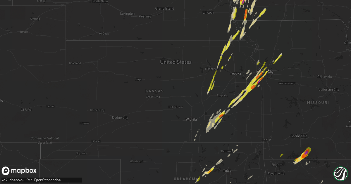
Hail Map in Kansas on April 13, 2018
Get this storm
April 13 map
$229
one time, instant access
Download today. No call, no setup
Keep the $229
Bought the map and want the full workflow? Apply the entire $229 to a subscription within 7 days. None of it is wasted.
Every map, not just this one
This buys you this map. Subscription and you get every map we run, in the markets you choose from a few cities to whole states to nationwide. Plus real-time alerts the moment a storm fires.
Contact data
Name, contact info, occupancy, even credit band for addresses in the footprint. You go from where it hit to who to call.
Become the source they trust
Unlimited branding weather history reports on demand. You already have the documented answer ready for the property owner, and you are the one who showed up with it.
Property data and RoofTrace estimates
Pull up any address you have got, its value and the exact code rules for that jurisdiction, straight from One Click Code. Then RoofTrace estimates the squares, pitch, and roof value, priced the way you price.
Storm reports in Kansas
Kansas
| Date | Description |
|---|---|
| 04/13/20186:55 PM CDT | Relayed to johnson co. Em from spotter. |
| 04/13/20186:19 PM CDT | A local report indicates 1.00 inch wind near OTTAWA |
| 04/13/20186:03 PM CDT | 151st and black bob. |
| 04/13/20186:02 PM CDT | A local report indicates 1.50 inch wind near 2 NNW STANLEY |
| 04/13/20186:00 PM CDT | A local report indicates 1.75 inch wind near 4 SE LACKMANS |
| 04/13/20186:00 PM CDT | Via social media. |
| 04/13/20185:55 PM CDT | Report via twitter with picture and quarter for reference. |
| 04/13/20185:55 PM CDT | A local report indicates 1.25 inch wind near 4 W STANLEY |
| 04/13/20185:55 PM CDT | Delayed report. |
| 04/13/20185:50 PM CDT | Report from nick bender. |
| 04/13/20185:48 PM CDT | A local report indicates 1.00 inch wind near 3 SE CLARE |
| 04/13/20185:33 PM CDT | At i-35 and sunflower rd. Relayed by johnson county em. |
| 04/13/20185:07 PM CDT | Power lines downed across the road. |
| 04/13/20184:52 PM CDT | A local report indicates 1.00 inch wind near 5 WSW WELLSVILLE |
| 04/13/20184:42 PM CDT | A local report indicates 1.00 inch wind near 1 N OTTAWA |
| 04/13/20184:40 PM CDT | Hail slightly larger than quarter size per twitter report. |
| 04/13/20184:21 PM CDT | A local report indicates 1.00 inch wind near 4 NE WILLIAMSBURG |
| 04/13/20184:11 PM CDT | A local report indicates 1.00 inch wind near 1 WNW CIRCLEVILLE |
| 04/13/20183:48 PM CDT | Estimated 60 mph winds with penny size hail. |
| 04/13/20183:41 PM CDT | A local report indicates 1.00 inch wind near CENTRALIA |
| 04/13/20183:35 PM CDT | A local report indicates 1.00 inch wind near 5 NNE GRIDLEY |
| 04/13/20183:35 PM CDT | Mostly dime size hail with a few the size of quarters. |
| 04/13/20183:20 PM CDT | Near hwy 16 and major jenkins rd. |
| 04/13/20183:14 PM CDT | A local report indicates 1.00 inch wind near 7 ENE EUREKA |
| 04/13/20182:57 PM CDT | Pea to quarter size hail. |
| 04/13/20182:37 PM CDT | A local report indicates 71 MPH wind near EUREKA AIRPORT |
| 04/13/20182:21 AM CDT | At 721 PM CDT, a severe thunderstorm was located over Lake Quivira, moving northeast at 40 mph. HAZARD...Ping pong ball size hail and 60 mph wind gusts. SOURCE...Trained weather spotters. IMPACT...People and animals outdoors will be injured. Expect hail damage to roofs, siding, windows, and vehicles. Expect wind damage to roofs, siding, and trees. Locations impacted include... Kansas City, Overland Park, Shawnee, Lenexa, Liberty, Gladstone, Prairie Village, Merriam, Mission, Smithville, Kearney, Parkville, Edwardsville, North Kansas City, Fairway, Mission Hills, Riverside, Westwood, Claycomo and Lake Quivira.This includes the following highways... Interstate 70 in Missouri between mile markers 0 and 4. Interstate 70 in Kansas between mile markers 413 and 423. Interstate 35 in Missouri between mile markers 0 and 24. Interstate 35 in Kansas between mile markers 224 and 235. Interstate 29 between mile markers 0 and 8. Interstate 635 between mile markers 0 and 12. Interstate 435 between mile markers 5 and 11, and between milemarkers 39 and 57. |
| 04/13/20181:11 AM CDT | At 611 PM CDT, a severe thunderstorm was located 7 miles east of Falls City, moving northeast at 40 mph. HAZARD...Quarter size hail. SOURCE...Radar indicated. IMPACT...Damage to vehicles is expected. Locations impacted include... Rulo and Preston. |
| 04/13/20181:06 AM CDT | At 605 PM CDT, a severe thunderstorm was located over Pittsburg, moving northeast at 35 mph. HAZARD...60 mph wind gusts and quarter size hail. SOURCE...Radar indicated. IMPACT...Hail damage to vehicles is expected. Expect wind damage to roofs, siding, and trees. Locations impacted include... Pittsburg... Prairie State Park... Frontenac... Arma... Liberal... Mulberry... Chicopee... Mindenmines... Franklin... Arcadia... Bronaugh... Burgess... Croweburg... Yale... Iantha... Oskaloosa... Verdella... Lone Oak... Hannon... |
| 04/13/201812:55 AM CDT | At 555 PM CDT, severe thunderstorms were located along a line extending from Edwardsville to near Olathe, moving northeast at 45 mph. HAZARD...Ping pong ball size hail and 60 mph wind gusts. SOURCE...Trained weather spotters. IMPACT...People and animals outdoors will be injured. Expect hail damage to roofs, siding, windows, and vehicles. Expect wind damage to roofs, siding, and trees. Locations impacted include... Kansas City, Overland Park, Olathe, Independence, Lee's Summit, Shawnee, Blue Springs, Lenexa, Leavenworth, Leawood, Raytown, Liberty, Gladstone, Grandview, Belton, Prairie Village, Raymore, Grain Valley, Lansing and Merriam.This includes the following highways... Interstate 70 in Missouri between mile markers 0 and 27. Interstate 70 in Kansas between mile markers 410 and 423. Interstate 35 in Missouri between mile markers 0 and 28. Interstate 35 in Kansas between mile markers 213 and 235. Interstate 29 between mile markers 0 and 22. Interstate 635 between mile markers 0 and 12. Interstate 470 between mile markers 0 and 16. Interstate 435 between mile markers 0 and 83. Kansas Turnpike between mile markers 220 and 226. |
| 04/12/201811:42 PM CDT | At 442 PM CDT, a severe thunderstorm was located near Ottawa, moving northeast at 45 mph. HAZARD...60 mph wind gusts and half dollar size hail. SOURCE...Radar indicated. IMPACT...Hail damage to vehicles is expected. Expect wind damage to roofs, siding, and trees. Locations impacted include... Overland Park, Olathe, Shawnee, Lenexa, Gardner, De Soto, Spring Hill, Edgerton, Linwood, Clare, Lackmans and Clearview City.This includes the following highways... Interstate 35 in Kansas between mile markers 200 and 221. Interstate 435 between mile markers 1 and 2. Kansas Turnpike near mile marker 217. |
| 04/12/201811:32 PM CDT | At 432 PM CDT, a severe thunderstorm was located 6 miles west of Westphalia, moving northeast at 55 mph. HAZARD...Ping pong ball size hail and 60 mph wind gusts. SOURCE...Radar indicated. IMPACT...People and animals outdoors will be injured. Expect hail damage to roofs, siding, windows, and vehicles. Expect wind damage to roofs, siding, and trees. Locations impacted include... Wellsville, Richmond, Princeton, Lane, Rantoul and Harris. This includes Interstate 35 between mile markers 184 and 185, andbetween mile markers 196 and 198. |
| 04/12/201811:27 PM CDT | At 427 PM CDT, a severe thunderstorm was located 5 miles east of Bern, or 6 miles northwest of Sabetha, moving northeast at 40 mph. HAZARD...60 mph wind gusts and quarter size hail. SOURCE...Radar indicated. IMPACT...Hail damage to vehicles is expected. Expect wind damage to roofs, siding, and trees. Locations impacted include... Verdon, Stella, Shubert, Dawson, Salem, Barada, Indian Cave State Park, The Highway 75 And 8 Junction and Camp Cornhusker.This includes Highway 75 in Nebraska between mile markers 1 and 17. |
| 04/12/201811:22 PM CDT | At 422 PM CDT, a severe thunderstorm was located 3 miles northeast of Delaware, moving northeast at 45 mph. HAZARD...60 mph wind gusts and quarter size hail. SOURCE...Radar indicated. IMPACT...Hail damage to vehicles is expected. Expect wind damage to roofs, siding, and trees. Locations in or near the path include... Nowata... Delaware... Lenapah... Hollow... |
| 04/12/201811:18 PM CDT | At 418 PM CDT, a severe thunderstorm was located near Pomona, moving northeast at 60 mph. HAZARD...Golf ball size hail and 60 mph wind gusts. SOURCE...Radar indicated. IMPACT...People and animals outdoors will be injured. Expect hail damage to roofs, siding, windows, and vehicles. Expect wind damage to roofs, siding, and trees. Locations impacted include... Lawrence, Ottawa, Baldwin City, Edgerton, Eudora, Centropolis, Pomona, Pleasant Grove and Vinland.This includes Kansas Turnpike between mile markers 201 and 205. |
| 04/12/201811:11 PM CDT | At 411 PM CDT, a severe thunderstorm was located 4 miles southeast of Seneca, moving northeast at 35 mph. HAZARD...Ping pong ball size hail and 60 mph wind gusts. SOURCE...Radar indicated. IMPACT...People and animals outdoors will be injured. Expect hail damage to roofs, siding, windows, and vehicles. Expect wind damage to roofs, siding, and trees. Locations impacted include... Sabetha, Seneca, Centralia, Bern, Goff, Oneida and Woodlawn. |
| 04/12/201811:10 PM CDT | At 409 PM CDT, a severe thunderstorm was located 4 miles northwest of Harris, moving northeast at 40 mph. HAZARD...60 mph wind gusts and half dollar size hail. SOURCE...Radar indicated. IMPACT...Hail damage to vehicles is expected. Expect wind damage to roofs, siding, and trees. Locations impacted include... Ottawa, Wellsville, Williamsburg, Princeton and Rantoul. This includes Interstate 35 between mile markers 170 and 198. |
| 04/12/201811:09 PM CDT | At 409 PM CDT, a severe thunderstorm was located 4 miles southwest of Circleville, moving northeast at 40 mph. HAZARD...60 mph wind gusts and quarter size hail. SOURCE...Radar indicated. IMPACT...Hail damage to vehicles is expected. Expect wind damage to roofs, siding, and trees. Locations impacted include... Holton, Horton, Wetmore, Fairview, Circleville, Netawaka, Soldier, Goff, Powhattan, Kickapoo Reservation and Woodlawn. |
| 04/12/201811:01 PM CDT | At 401 PM CDT, severe thunderstorms were located along a line extending from 6 miles south of Gridley to 5 miles west of Toronto, moving northeast at 35 mph. HAZARD...60 mph wind gusts and half dollar size hail. SOURCE...Radar indicated. IMPACT...Hail damage to vehicles is expected. Expect wind damage to roofs, siding, and trees. Locations impacted include... Burlington and Le Roy. |
| 04/12/201810:49 PM CDT | At 348 PM CDT, a severe thunderstorm was located over New Strawn, moving northeast at 60 mph. HAZARD...Golf ball size hail and 60 mph wind gusts. SOURCE...Radar indicated. IMPACT...People and animals outdoors will be injured. Expect hail damage to roofs, siding, windows, and vehicles. Expect wind damage to roofs, siding, and trees. Locations impacted include... Pomona, Waverly, Williamsburg, Quenemo, Melvern, Princeton, Beto Junction and Harris.This includes Interstate 35 between mile markers 156 and 181. |
| 04/12/201810:49 PM CDT | At 349 PM CDT, a severe thunderstorm was located 9 miles northeast of Ochelata, moving northeast at 55 mph. HAZARD...60 mph wind gusts and quarter size hail. SOURCE...Trained weather spotters. IMPACT...Hail damage to vehicles is expected. Expect wind damage to roofs, siding, and trees. Locations in or near the path include... Bartlesville... Nowata... South Coffeyville... Delaware... Lenapah... Wann... |
| 04/12/201810:31 PM CDT | At 330 PM CDT, a severe thunderstorm was located 4 miles north of Paxico, moving northeast at 55 mph. HAZARD...60 mph wind gusts and half dollar size hail. SOURCE...Radar indicated. IMPACT...Hail damage to vehicles is expected. Expect wind damage to roofs, siding, and trees. Locations impacted include... Holton, St. Marys, Belvue, Emmett, Circleville, Delia, Soldier and Potawatomi Reservation. |
| 04/12/201810:18 PM CDT | At 318 PM CDT, a severe thunderstorm was located 6 miles southwest of Onaga, moving north at 60 mph. HAZARD...60 mph wind gusts and half dollar size hail. SOURCE...Radar indicated. IMPACT...Hail damage to vehicles is expected. Expect wind damage to roofs, siding, and trees. Locations impacted include... Seneca, Centralia, Axtell, Bern, Corning, Havensville, Goff, Vermillion, Oneida, Baileyville and Lillis. |
| 04/12/201810:15 PM CDT | At 314 PM CDT, a severe thunderstorm was located near Hamilton, or 13 miles northeast of Eureka, moving northeast at 50 mph. HAZARD...70 mph wind gusts and nickel size hail. SOURCE...Radar indicated. IMPACT...Expect considerable tree damage. Damage is likely to mobile homes, roofs, and outbuildings. Locations impacted include... Hamilton and Virgil. |
| 04/12/201810:09 PM CDT | At 308 PM CDT, a severe thunderstorm was located 5 miles south of Alta Vista, moving northeast at 50 mph. HAZARD...60 mph wind gusts and half dollar size hail. SOURCE...Radar indicated. IMPACT...Hail damage to vehicles is expected. Expect wind damage to roofs, siding, and trees. Locations impacted include... Wamego, Alma, St. Marys, Maple Hill, Alta Vista, McFarland, Paxico, Belvue, Louisville and Volland.This includes Interstate 70 between mile markers 323 and 340. |
| 04/12/201810:05 PM CDT | At 305 PM CDT, severe thunderstorms were located along a line extending from 7 miles northwest of Gridley to 6 miles southeast of Hamilton to 6 miles southeast of Eureka, moving northeast at 50 mph. HAZARD...60 mph wind gusts and half dollar size hail. SOURCE...Radar indicated. IMPACT...Hail damage to vehicles is expected. Expect wind damage to roofs, siding, and trees. Locations impacted include... Burlington, Waverly, New Strawn, Gridley, Le Roy and John Redmond Reservoir.This includes Interstate 35 between mile markers 160 and 167. |
| 04/12/201810:03 PM CDT | At 303 PM CDT, a severe thunderstorm was located near Eureka, moving northeast at 45 mph. HAZARD...70 mph wind gusts and nickel size hail. SOURCE...Radar indicated. IMPACT...Expect considerable tree damage. Damage is likely to mobile homes, roofs, and outbuildings. Locations impacted include... Eureka and Climax. |
| 04/12/20189:48 PM CDT | At 248 PM CDT, a severe thunderstorm was located 5 miles north of Volland, moving north at 65 mph. HAZARD...60 mph wind gusts and half dollar size hail. SOURCE...Radar indicated. IMPACT...Hail damage to vehicles is expected. Expect wind damage to roofs, siding, and trees. Locations impacted include... Wamego, Westmoreland, Onaga, St. George, Belvue, Louisville, Soldier, Havensville, Wheaton and Volland.This includes Interstate 70 between mile markers 315 and 327. |
| 04/12/20189:41 PM CDT | At 240 PM CDT, a severe thunderstorm was located 6 miles southwest of Hamilton, or 7 miles north of Eureka, moving northeast at 60 mph. HAZARD...70 mph wind gusts and nickel size hail. SOURCE...Radar indicated. IMPACT...Expect considerable tree damage. Damage is likely to mobile homes, roofs, and outbuildings. Locations impacted include... Eureka, Madison, Hamilton, Virgil, Eureka City Lake, Thrall and Eureka Airport. |
| 04/12/20189:23 PM CDT | At 222 PM CDT, severe thunderstorms were located along a line extending from 13 miles northwest of Hamilton to 7 miles southwest of Eureka, moving northeast at 55 mph. HAZARD...60 mph wind gusts and half dollar size hail. SOURCE...Radar indicated. IMPACT...Hail damage to vehicles is expected. Expect wind damage to roofs, siding, and trees. Locations impacted include... Emporia, Lebo, Olpe, Melvern, Hartford, Neosho Rapids, Reading, Admire, Olivet, Beto Junction and Melvern Lake.This includes the following highways... Interstate 35 between mile markers 128 and 160. Kansas Turnpike between mile markers 116 and 147. |
| 04/12/20189:09 PM CDT | At 209 PM CDT, a severe thunderstorm was located 10 miles west of Strong City, moving northeast at 55 mph. HAZARD...Golf ball size hail and 60 mph wind gusts. SOURCE...Radar indicated. IMPACT...People and animals outdoors will be injured. Expect hail damage to roofs, siding, windows, and vehicles. Expect wind damage to roofs, siding, and trees. Locations impacted include... Northeastern Manhattan, Council Grove, Alma, Eskridge, Alta Vista, Dwight, McFarland, Paxico, Wilsey, Parkerville, Keene, Council Grove Lake and Volland.This includes Interstate 70 between mile markers 311 and 342. |
| 04/12/20187:07 PM CDT | A local report indicates 1.00 inch wind near 2 NW OLATHE |
All States Impacted by Hail Map on April 13, 2018
Cities Impacted by Hail Map on April 13, 2018
- Fredericksburg, TX
- Mason, TX
- Doss, TX
- Shawnee, KS
- Olathe, KS
- Lenexa, KS
- Gardner, KS
- Aubrey, TX
- Denton, TX
- Schertz, TX
- Cibolo, TX
- Seguin, TX
- Marion, TX
- Jennings, OK
- Yale, OK
- Cushing, OK
- Oak Grove, AR
- Green Forest, AR
- Kirbyville, MO
- Powersite, MO
- Ridgedale, MO
- Kissee Mills, MO
- Taneyville, MO
- Hollister, MO
- Omaha, AR
- Branson, MO
- Forsyth, MO
- Blue Eye, MO
- Cedarcreek, MO
- Mullin, TX
- Goldthwaite, TX
- Tyler, TX
- Jonesboro, TX
- Leonard, TX
- Kingston, OK
- Iowa Falls, IA
- Alden, IA
- Dows, IA
- Leawood, KS
- Overland Park, KS
- Spring Hill, KS
- Williamsburg, KS
- Pomona, KS
- Burlington, KS
- Gridley, KS
- Waverly, KS
- Walnut, IA
- Cleburne, TX
- Essex, IA
- Shenandoah, IA
- Leslie, AR
- Charleston, AR
- Kansas City, MO
- Wilsey, KS
- Council Grove, KS
- Strong City, KS
- Sabinal, TX
- Seminole, OK
- Piedmont, KS
- Cambridge, KS
- Eureka, KS
- Latham, KS
- Virgil, KS
- Hamilton, KS
- Azle, TX
- Horatio, AR
- Lockesburg, AR
- Dierks, AR
- Coolidge, TX
- Jefferson, IA
- Gowrie, IA
- Paton, IA
- Delaware, OK
- Treynor, IA
- Silver City, IA
- Aquilla, TX
- Sherman, TX
- Howe, TX
- Colbert, OK
- Hendrix, OK
- Denison, TX
- Whitesboro, TX
- Mckinney, TX
- Onaga, KS
- Westmoreland, KS
- Mount Calm, TX
- Seneca, KS
- Sabetha, KS
- Oneida, KS
- Bern, KS
- Okmulgee, OK
- Eastman, WI
- Muscoda, WI
- Lansing, IA
- Merrimac, WI
- Hillpoint, WI
- Portage, WI
- Plain, WI
- Blue River, WI
- Postville, IA
- Gays Mills, WI
- Cazenovia, WI
- Waukon, IA
- North Freedom, WI
- Rock Springs, WI
- Ferryville, WI
- Richland Center, WI
- Castalia, IA
- Baraboo, WI
- Poynette, WI
- Soldiers Grove, WI
- Reedsburg, WI
- Ossian, IA
- Harpers Ferry, IA
- Decorah, IA
- Waterville, IA
- Loganville, WI
- Pardeeville, WI
- Rayville, LA
- Hominy, OK
- Barnsdall, OK
- Frisco, TX
- Worthington, MN
- Geuda Springs, KS
- Prosper, TX
- Booneville, AR
- Pearsall, TX
- Celina, TX
- Tullos, LA
- Olla, LA
- Churdan, IA
- Van Alstyne, TX
- Hubbard, TX
- Dawson, TX
- Iredell, TX
- Hico, TX
- Alta Vista, KS
- Villisca, IA
- Axtell, TX
- Mart, TX
- Waco, TX
- Massena, IA
- Stanton, IA
- Grant, IA
- Elliott, IA
- Griswold, IA
- Cumberland, IA
- Clarinda, IA
- Atoka, OK
- Hamilton, TX
- Bastrop, LA
- Oak Ridge, LA
- Mer Rouge, LA
- Bells, TX
- Whitewright, TX
- Savoy, TX
- Bonham, TX
- Rio Vista, TX
- Grandview, TX
- Kopperl, TX
- Blum, TX
- Henderson, IA
- Emerson, IA
- Red Oak, IA
- Carson, IA
- Georgetown, TX
- Lead Hill, AR
- Stillwater, OK
- Wynnewood, OK
- Elmore City, OK
- Pauls Valley, OK
- Crawford, TX
- Valley Mills, TX
- Coalgate, OK
- Harrison, AR
- Lawson, MO
- Polo, MO
- Trenton, TX
- Florence, TX
- Bertram, TX
- Briggs, TX
- Dilley, TX
- Crystal City, TX
- Scranton, IA
- Harcourt, IA
- Otho, IA
- Coon Rapids, IA
- Lehigh, IA
- Fort Dodge, IA
- Callender, IA
- Kerens, TX
- Kemp, TX
- Fort Hood, TX
- Glencoe, OK
- Wellston, OK
- Godley, TX
- Kansas City, KS
- Lometa, TX
- Gainesville, TX
- Muenster, TX
- Exira, IA
- Macedonia, IA
- Glenwood, IA
- Hamlin, IA
- Avoca, IA
- Harlan, IA
- Mineola, IA
- Hancock, IA
- Marne, IA
- Audubon, IA
- Elk Horn, IA
- Council Bluffs, IA
- Hastings, IA
- Minden, IA
- Shelby, IA
- Oakland, IA
- Mulberry, AR
- Lavaca, AR
- Garnett, KS
- Le Roy, KS
- Westphalia, KS
- Maud, OK
- Whitney, TX
- Coleman, OK
- Caddo, OK
- Caney, OK
- Durant, OK
- Milburn, OK
- Madill, OK
- Kenefic, OK
- Richmond, KS
- Princeton, KS
- Bonner Springs, KS
- Eudora, KS
- De Soto, KS
- Independence, MO
- Wellsville, KS
- Prairie Village, KS
- Ottawa, KS
- Paola, KS
- Baldwin City, KS
- Rantoul, KS
- Edgerton, KS
- Latimer, IA
- Hampton, IA
- Boley, OK
- Wewoka, OK
- Earlsboro, OK
- Macomb, OK
- Tecumseh, OK
- Okemah, OK
- Paden, OK
- Asher, OK
- Castle, OK
- Bristow, OK
- San Antonio, TX
- Universal City, TX
- Jbsa Randolph, TX
- Converse, TX
- Cleveland, OK
- Terlton, OK
- Grenola, KS
- Howard, KS
- Severy, KS
- Ozone, AR
- Clarksville, AR
- Star, TX
- Elm Mott, TX
- Meridian, TX
- Penelope, TX
- Oglesby, TX
- Riesel, TX
- Purmela, TX
- West, TX
- Clifton, TX
- Bynum, TX
- Lampasas, TX
- Morgan, TX
- Trinidad, TX
- Kempner, TX
- Powell, TX
- Wortham, TX
- Malone, TX
- Hillsboro, TX
- China Spring, TX
- Evant, TX
- Prairie Hill, TX
- Cranfills Gap, TX
- Rice, TX
- Mertens, TX
- Eustace, TX
- Abbott, TX
- Van, TX
- Mexia, TX
- Ben Wheeler, TX
- Athens, TX
- Purdon, TX
- Gatesville, TX
- Mabank, TX
- Corsicana, TX
- Blooming Grove, TX
- Canton, TX
- San Saba, TX
- Barry, TX
- Copperas Cove, TX
- Murchison, TX
- Frost, TX
- Mayville, WI
- Horicon, WI
- Delmont, SD
- Wagner, SD
- Bokchito, OK
- Cowgill, MO
- Centralia, KS
- Willow City, TX
- Ravenna, TX
- Ivanhoe, TX
- Telephone, TX
- Tom Bean, TX
- Ector, TX
- Tishomingo, OK
- Burnett, WI
- Beaver Dam, WI
- Anna, TX
- Brock, NE
- Auburn, NE
- New Hampton, IA
- Elma, IA
- Ionia, IA
- Hamburg, IA
- Percival, IA
- Tabor, IA
- Sidney, IA
- Thurman, IA
- Mill Creek, OK
- Dayton, IA
- Pilot Mound, IA
- Westboro, MO
- Coin, IA
- Mound City, MO
- Craig, MO
- Falls City, NE
- Northboro, IA
- Blanchard, IA
- Fairfax, MO
- Rulo, NE
- Tarkio, MO
- Covington, TX
- Itasca, TX
- Wamego, KS
- Justin, TX
- Rhome, TX
- Rock, KS
- Udall, KS
- Jbsa Ft Sam Houston, TX
- Saint Hedwig, TX
- White, SD
- Collinsville, TX
- Wolfe City, TX
- Ladonia, TX
- Foreman, AR
- Haworth, OK
- Winthrop, AR
- Hamilton, MO
- Excelsior Springs, MO
- Kingston, MO
- Winona, TX
- Flint, TX
- Whitehouse, TX
- Arp, TX
- Natalia, TX
- Lytle, TX
- Parkston, SD
- Bartlesville, OK
- Ochelata, OK
- Ramona, OK
- Nebraska City, NE
- Mena, AR
- Sanger, TX
- Krum, TX
- Cecil, AR
- Fort Smith, AR
- Alma, AR
- Nemaha, NE
- Verdon, NE
- Shubert, NE
- Salem, NE
- Dawson, NE
- Johnson, NE
- Peru, NE
- Pacific Junction, IA
- Humboldt, NE
- Malvern, IA
- Julian, NE
- Smithville, OK
- Steuben, WI
- Monona, IA
- Luana, IA
- Burleson, TX
- Alvarado, TX
- Clayton, OK
- Snow, OK
- Nashoba, OK
- Blue Ridge, TX
- Wisconsin Dells, WI
- Yates Center, KS
- Asherton, TX
- Big Wells, TX
- Hackett, AR
- Huntington, AR
- Greenwood, AR
- Ozark, AR
- Cameron, OK
- Van Buren, AR
- Barling, AR
- Boone, IA
- Stratford, IA
- Stanhope, IA
- Weatherford, TX
- Argyle, TX
- Belmond, IA
- Kanawha, IA
- Lenox, IA
- Braddyville, IA
- Sharpsburg, IA
- Bedford, IA
- Clearmont, MO
- Gravity, IA
- New Market, IA
- Burlington Junction, MO
- Skidmore, MO
- Berryville, AR
- Troup, TX
- Rockford, IA
- Marble Rock, IA
- Ripley, OK
- Fairfax, SD
- Spencer, NE
- Melissa, TX
- Little Elm, TX
- Moore, TX
- Fort Worth, TX
- Stonewall, OK
- Iona, MN
- Fulda, MN
- Rattan, OK
- Antlers, OK
- Hugo, OK
- Campbellsport, WI
- Kewaskum, WI
- Lomira, WI
- Charles City, IA
- D Hanis, TX
- Leon, KS
- Atlanta, KS
- Wilmont, MN
- Joshua, TX
- Nemo, TX
- Glen Rose, TX
- Muldrow, OK
- Roland, OK
- Belvue, KS
- Nowata, OK
- Downsville, LA
- Lampe, MO
- Colfax, LA
- Atlanta, LA
- Farnhamville, IA
- Corning, KS
- Hendricks, MN
- Klemme, IA
- Goodell, IA
- Gordonville, TX
- Mead, OK
- Rutland, SD
- Volga, SD
- Nunda, SD
- Lawrence, KS
- Wanette, OK
- Streetman, TX
- Richland, TX
- Oak Grove, LA
- Theresa, WI
- Brownsville, WI
- Waldron, AR
- Mcalester, OK
- Kiowa, OK
- Roff, OK
- Wardville, OK
- Stuart, OK
- Springer, OK
- Sulphur, OK
- Savanna, OK
- Centrahoma, OK
- Ardmore, OK
- Blanco, OK
- Davis, OK
- Tupelo, OK
- Como, TX
- Yantis, TX
- Sulphur Springs, TX
- Stringtown, OK
- Daisy, OK
- Pittsburg, OK
- De Kalb, TX
- Burnet, TX
- Jarrell, TX
- Salado, TX
- Killeen, TX
- Devine, TX
- Bennington, OK
- Boswell, OK
- Soper, OK
- Bigfoot, TX
- Paxico, KS
- Pocola, OK
- Perkins, OK
- Carney, OK
- Kearney, MO
- Ogden, IA
- Oark, AR
- Ponder, TX
- Pilot Point, TX
- Choudrant, LA
- Calhoun, LA
- De Queen, AR
- Collinston, LA
- Jones, LA
- Llano, TX
- Platte City, MO
- Weston, MO
- Burnside, IA
- Round Mountain, TX
- Tioga, TX
- Gunter, TX
- Thackerville, OK
- Sheboygan Falls, WI
- Adell, WI
- Waldo, WI
- Random Lake, WI
- Cedar Grove, WI
- Oostburg, WI
- Rosalia, KS
- Burden, KS
- Beaumont, KS
- Kilgore, TX
- Overton, TX
- Dalton, WI
- Bigelow, MN
- Sibley, IA
- Emmett, KS
- Saint Marys, KS
- Decatur, TX
- Bailey, TX
- Flower Mound, TX
- Roanoke, TX
- Lake Dallas, TX
- Dodd City, TX
- Lewisville, TX
- The Colony, TX
- Haslet, TX
- Boyd, TX
- Newark, TX
- Marble Falls, TX
- Mansfield, TX
- Lillian, TX
- Grand Junction, IA
- Dana, IA
- Warren, AR
- Horseshoe Bay, TX
- Spicewood, TX
- Fairfield, TX
- Geneva, IA
- Ackley, IA
- Dwight, KS
- Lane, OK
- Valley View, TX
- Rio, WI
- Cambria, WI
- Hulbert, OK
- Tahlequah, OK
- Fort Gibson, OK
- Magazine, AR
- Marion, LA
- Bradleyville, MO
- Lismore, MN
- Tonganoxie, KS
- Linwood, KS
- Hillsboro, WI
- La Valle, WI
- Shawnee, OK
- Beggs, OK
- Allenton, WI
- Circleville, KS
- Soldier, KS
- Holton, KS
- Georgetown, LA
- Lenapah, OK
- McClelland, IA
- Kimballton, IA
- Kirkman, IA
- Altus, AR
- Wonewoc, WI
- Prairie Du Sac, WI
- Randolph, WI
- Temple, TX
- Pawnee, OK
- Forestburg, TX
- Viola, WI
- Spiro, OK
- Finley, OK
- Moyers, OK
- Columbia, LA
- Wetmore, KS
- Atlantic, IA
- Glenwood, AR
- Caddo Gap, AR
- Bonnerdale, AR
- Bullard, TX
- Belgium, WI
- Cotulla, TX
- Mcloud, OK
- Maramec, OK
- Hartman, AR
- Nebo, IL
- Oxford, KS
- Pearl, IL
- Hartford, AR
- Spencer, SD
- Emory, TX
- McLouth, KS
- Mounds, OK
- Venus, TX
- Fall River, WI
- Columbus, WI
- Boles, AR
- Tow, TX
- Glidden, IA
- Lexington, OK
- Noble, OK
- Jewell, IA
- Ellsworth, IA
- Alexandria, SD
- Radcliffe, IA
- Nashua, IA
- Madison, SD
- Ramona, SD
- Brownsboro, TX
- Emery, SD
- Goff, KS
- Vermillion, KS
- Bluffton, TX
- Burdick, KS
- Winfield, KS
- Bremond, TX
- Rock Port, MO
- Ringling, OK
- Wilson, OK
- Lone Grove, OK
- Tryon, OK
- Tuskahoma, OK
- Irwin, IA
- Brayton, IA
- Kamrar, IA
- Story City, IA
- Washburn, MO
- Exeter, MO
- Seligman, MO
- Cassville, MO
- Garrison, MO
- Oldfield, MO
- Rueter, MO
- Ava, MO
- Rainbow, TX
- Celeste, TX
- Fort Atkinson, IA
- Lodi, WI
- Boscobel, WI
- Calmar, IA
- Juneau, WI
- Cresco, IA
- Lake Andes, SD
- Tripp, SD
- Armour, SD
- Ivanhoe, MN
- Astoria, SD
- Elkton, SD
- Ocheyedan, IA
- Manhattan, KS
- Alma, KS
- Mission, KS
- Riverside, MO
- Smithville, MO


