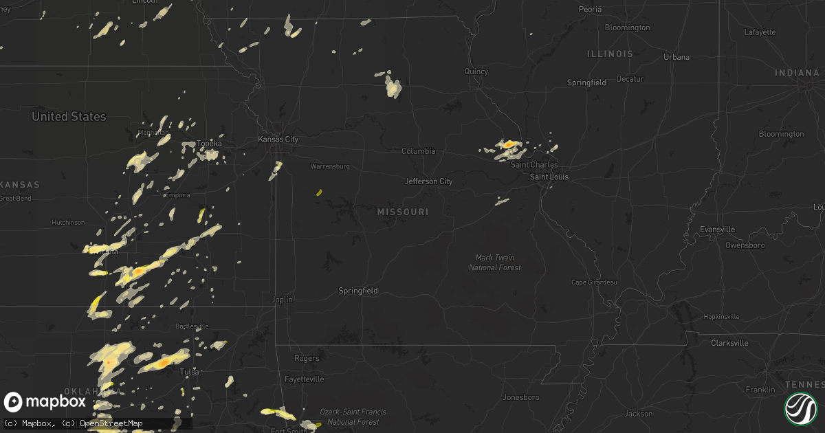
Hail Map in Missouri on April 13, 2014
Get this storm
April 13 map
$229
one time, instant access
Download today. No call, no setup
Keep the $229
Bought the map and want the full workflow? Apply the entire $229 to a subscription within 7 days. None of it is wasted.
Every map, not just this one
This buys you this map. Subscription and you get every map we run, in the markets you choose from a few cities to whole states to nationwide. Plus real-time alerts the moment a storm fires.
Contact data
Name, contact info, occupancy, even credit band for addresses in the footprint. You go from where it hit to who to call.
Become the source they trust
Unlimited branding weather history reports on demand. You already have the documented answer ready for the property owner, and you are the one who showed up with it.
Property data and RoofTrace estimates
Pull up any address you have got, its value and the exact code rules for that jurisdiction, straight from One Click Code. Then RoofTrace estimates the squares, pitch, and roof value, priced the way you price.
Storm reports in Missouri
Missouri
| Date | Description |
|---|---|
| 04/13/20146:56 PM CDT | A local report indicates 60 MPH wind near 2 W BOLIVAR |
| 04/13/20146:48 PM CDT | A local report indicates 60 MPH wind near HUMANSVILLE |
| 04/13/20146:40 PM CDT | Wind blown off barn. |
| 04/13/20146:34 PM CDT | A local report indicates 67 MPH wind near LOCKWOOD |
| 04/13/20146:34 PM CDT | 62.1 mph. No damage noted. |
| 04/13/20145:55 PM CDT | A local report indicates 1.00 inch wind near URICH |
| 04/13/20145:53 PM CDT | Joplin airport |
| 04/13/20145:30 PM CDT | In rich hill... Semi flipped over and power pole down. |
| 04/13/20145:22 PM CDT | Estimated 60 to 70 mph winds. Shingles lost on one roof. |
| 04/13/20144:40 PM CDT | A local report indicates 1.00 inch wind near BELTON |
| 04/13/20144:15 PM CDT | *** 2 inj *** damaged roof blew into an apartment complex breaking the window and causing 2 injuries. Report of power pole down and power outage from broken tree limbs. |
| 04/13/20144:11 PM CDT | Portion of roof removed from commerical building...a few homes with siding and shingle damage...pole barn pushed off of block foundation...delayed report |
| 04/13/20144:00 PM CDT | Relayed via emergency manager. |
| 04/13/20143:43 PM CDT | Strong winds ongoing at time of report. |
| 04/13/20143:35 PM CDT | Estimated 50 to 60 mph wind gusts inside wind break. |
| 04/13/20143:15 PM CDT | Roof damage to metal shed near weston missouri. Time estimated. Report via local media. |
| 04/13/20143:15 PM CDT | Roof damage to metal shed near weston missouri. Time estimated. Report via local media. |
| 04/13/20148:12 AM CDT | A local report indicates 1.00 inch wind near ST. CLAIR |
| 04/13/20147:51 AM CDT | A local report indicates 1.00 inch wind near 3 NW WINFIELD |
| 04/13/20147:50 AM CDT | Dime to nickel size hail covering the roadway with a few quarter stones. Reported by clinton county em who was driving through the area. |
| 04/13/20147:45 AM CDT | Near intersection of w and highway 47. |
| 04/12/20148:35 PM CDT | Wind damage to three outbuildings and trees. |
| 04/12/20147:50 PM CDT | Tree blown across highway d near ha ha tonka state park. |
| 04/12/20147:47 PM CDT | At the office of emergency management |
| 04/12/20147:25 PM CDT | Small 10 ft tall tree downed. |
| 04/12/20147:03 PM CDT | A local report indicates 60 MPH wind near 3 NNE FRISTOE |
| 04/12/20147:01 PM CDT | 50 to 60 mph winds estimated. |
All States Impacted by Hail Map on April 13, 2014
Cities Impacted by Hail Map on April 13, 2014
- Goddard, KS
- Garden Plain, KS
- Andale, KS
- Chelsea, OK
- Claremore, OK
- Earlsboro, OK
- Shawnee, OK
- Seminole, OK
- Okemah, OK
- Bowie, TX
- Henrietta, TX
- Bellevue, TX
- Wewoka, OK
- Holdenville, OK
- Tobias, NE
- Tecumseh, OK
- Osage, OK
- Skiatook, OK
- Sperry, OK
- Prue, OK
- Cleveland, OK
- Hominy, OK
- Terlton, OK
- Ringling, OK
- Wilson, OK
- Healdton, OK
- Overbrook, OK
- Loco, OK
- Cecil, AR
- Charleston, AR
- Lavaca, AR
- Colwich, KS
- Wichita, KS
- Palmyra, NE
- Douglas, NE
- Panama, NE
- Bennet, NE
- Adams, NE
- Hickman, NE
- Unadilla, NE
- Lampasas, TX
- Ethel, MO
- Grapeland, TX
- Upland, NE
- Hildreth, NE
- Bloomington, NE
- Franklin, NE
- Goldthwaite, TX
- Washington, OK
- Norman, OK
- Brighton, IL
- Alton, IL
- Duncan, OK
- Foster, OK
- Rush Springs, OK
- Elmore City, OK
- Marlow, OK
- Walton, KS
- Newton, KS
- Valera, TX
- Murray, NE
- Union, NE
- Plattsmouth, NE
- Nehawka, NE
- Dublin, TX
- Atoka, OK
- Coalgate, OK
- Blackwell, OK
- New Cambria, MO
- Olpe, KS
- Madison, KS
- Oklahoma City, OK
- Ponca City, OK
- Peru, KS
- Niotaze, KS
- Mulberry, AR
- Council Grove, KS
- Wilsey, KS
- Plymouth, NE
- Jansen, NE
- Carbondale, KS
- Auburn, KS
- Wakarusa, KS
- Berryton, KS
- Overbrook, KS
- Topeka, KS
- Rock, KS
- Atlanta, KS
- Americus, KS
- Allen, KS
- Winfield, MO
- De Kalb, MS
- Saint George, KS
- Westmoreland, KS
- Marion, KS
- Mulhall, OK
- Covington, OK
- Perry, OK
- Orlando, OK
- Marland, OK
- Red Rock, OK
- Stillwater, OK
- Morrison, OK
- Billings, OK
- Ralston, OK
- Pawnee, OK
- Gorman, TX
- De Leon, TX
- Manhattan, KS
- Maize, KS
- Tuscola, TX
- Coyle, OK
- Guthrie, OK
- Bristow, OK
- Depew, OK
- Powersville, MO
- Unionville, MO
- Newalla, OK
- Brussels, IL
- Golden Eagle, IL
- Medford, OK
- Beggs, OK
- Mounds, OK
- Nocona, TX
- Benton, KS
- Andover, KS
- Edmond, OK
- Ladonia, TX
- Commerce, TX
- Klondike, TX
- Bruning, NE
- Latham, KS
- Strong City, KS
- Cedar Point, KS
- Lincolnville, KS
- Elmdale, KS
- Ripley, OK
- Saint Clair, MO
- Grenola, KS
- Comanche, OK
- Okmulgee, OK
- Noble, OK
- Rockdale, TX
- Le Roy, KS
- Fairfax, OK
- Shidler, OK
- Foley, MO
- Elsberry, MO
- Troy, MO
- Sumner, TX
- Arthur City, TX
- Bradley, OK
- Lindsay, OK
- Blanchard, OK
- Alex, OK
- Purcell, OK
- Union, MS
- Philadelphia, MS
- Collinsville, MS
- Blackwell, TX
- Daleville, MS
- Wolfe City, TX
- Williamsburg, KS
- Princeton, KS
- Carney, OK
- Tryon, OK
- Rising Star, TX
- Cisco, TX
- Desdemona, TX
- Carbon, TX
- Yates Center, KS
- Neosho Falls, KS
- Piqua, KS
- Belton, MO
- Stilwell, KS
- Cleveland, MO
- Peculiar, MO
- Louisburg, KS
- Bucyrus, KS
- High Hill, MO
- Bellflower, MO
- Severy, KS
- Eureka, KS
- Piedmont, KS
- Tishomingo, OK
- Holland, TX
- Albany, TX
- Kempner, TX
- Copperas Cove, TX
- Geneva, NE
- Godfrey, IL
- Abilene, TX
- Ovalo, TX
- Marietta, OK
- O'Fallon, MO
- Moscow Mills, MO
- White City, KS
- Woodbine, KS
- Bunch, OK
- Sallisaw, OK
- Benton, AR
- Traskwood, AR
- Maitland, MO
- Mound City, MO
- Hawk Point, MO
- Warrenton, MO
- Truxton, MO
- Durant, OK
- Breckenridge, TX
- Meriden, KS
- Ozawkie, KS
- Burlington, KS
- Wamego, KS
- Alma, KS
- Arcadia, OK
- Nardin, OK
- Braman, OK
- Fieldon, IL
- Independence, KS
- Neodesha, KS
- Mannsville, OK
- Mill Creek, OK
- Eskridge, KS
- Jones, OK
- Riley, KS
- Weleetka, OK
- Maud, OK
- Asher, OK
- Denver, MO
- Albany, MO
- Denison, TX
- Sadler, TX
- Pottsboro, TX
- Dexter, KS
- Maple City, KS
- Arkansas City, KS
- Whitesboro, TX
- Kingston, OK
- Lebanon, OK
- Coffeyville, KS
- Eagleville, MO
- Wilber, NE
- Douglass, KS
- Burden, KS
- Oxford, KS
- Winfield, KS
- Udall, KS
- Yale, OK
- Mannford, OK
- Maramec, OK
- Jennings, OK
- Emporia, KS
- Peabody, KS
- Clyde, TX
- Salado, TX
- Belton, TX
- Newkirk, OK
- Caldwell, KS
- South Haven, KS
- Wellington, KS
- Deer Creek, OK
- Wagoner, OK
- Elk City, KS
- Glenwood, IA
- Pacific Junction, IA
- Clarksville, TX
- Longton, KS
- Belle Plaine, KS
- Peck, KS
- Caney, OK
- Lane, OK
- Caddo, OK
- Cross Plains, TX
- Smithville, OK
- Collinsville, OK
- Ringgold, TX
- Cassoday, KS
- Bartlesville, OK
- Hastings, NE
- Moline, KS
- Fort Gibson, OK
- Hulbert, OK
- Tahlequah, OK
- Telephone, TX
- Burlington Junction, MO
- Elmo, MO
- Braddyville, IA
- Old Monroe, MO
- Milligan, NE
- Ohiowa, NE
- Western, NE
- Friend, NE
- Delia, KS
- Stroud, OK
- Worth, MO
- Bennington, OK
- Lometa, TX
- Savoy, TX
- Burns, KS
- Baird, TX
- Union, MO
- Bixby, OK
- Broken Arrow, OK
- Prague, OK
- Muenster, TX
- Sasakwa, OK
- Konawa, OK
- Ravenna, TX
- Bonham, TX
- Ardmore, OK
- Springer, OK
- Meridian, OK
- Gordonville, TX
- Dorchester, NE
- Bangs, TX
- Santa Anna, TX
- Coleman, TX
- Mullin, TX
- Falls City, NE
- Fairfax, MO
- Luther, OK
- Uniontown, AR
- Van Buren, AR
- Muldrow, OK
- Natural Dam, AR
- Cedarville, AR
- Rudy, AR
- Stilwell, OK
- Mcloud, OK
- Buckholts, TX
- Thorndale, TX
- Valley Center, KS
- Whitewater, KS
- Oologah, OK
- Talala, OK
- Fredonia, KS
- Wardville, OK
- Kiowa, OK
- Stringtown, OK
- Pittsburg, OK
- Brookesmith, TX
- Talpa, TX
- Brownwood, TX
- Grafton, IL
- Wingate, TX
- Herington, KS
- Hope, KS
- Lincoln, NE
- Murdock, NE
- Greenwood, NE
- Gretna, NE
- Waverly, NE
- Ashland, NE
- Alvo, NE
- Springfield, NE
- Gridley, KS
- Tulsa, OK
- Randolph, IA
- Junction City, KS
- Haysville, KS
- Clearwater, KS
- El Dorado, KS
- Garber, OK
- Antlers, OK
- Dwight, KS
- Wapanucka, OK
- Coleman, OK
- San Saba, TX
- Ballinger, TX
- Richland Springs, TX
- Tarkio, MO
- Chouteau, OK
- Mena, AR
- Little Rock, MS
- Bailey, MS
- Wanette, OK
- Macomb, OK
- Spencer, OK
- Harrah, OK
- Choctaw, OK
- Greenwich, KS
- Towanda, KS
- Maryville, MO
- Graham, MO
- Skidmore, MO
- Chandler, OK
- Davenport, OK
- Meeker, OK
- Naponee, NE
- Bells, TX
- Brookfield, MO
- Bucklin, MO
- New Boston, MO
- Thayer, KS
- Altoona, KS
- Hugo, OK
- Conway Springs, KS
- Adair, IL
- Boswell, OK
- Soper, OK
- Buffalo Gap, TX
- Humphreys, MO
- Milan, MO
- Blossom, TX
- Saint Jo, TX
- Potwin, KS
- Detroit, TX
- Cushing, OK
- Madill, OK
- Milburn, OK
- Kenefic, OK
- Bokchito, OK
- Trumbull, NE
- Porterville, MS
- Meridian, MS
- Lexington, OK
- Ravenwood, MO
- Pickering, MO
- Parnell, MO
- Stuart, OK
- Mcalester, OK
- Maple Hill, KS
- Paxico, KS
- Sulphur, OK
- Firth, NE
- Gainesville, TX
- Ochelata, OK
- Ramona, OK
- Barnsdall, OK
- Emmett, KS
- Saint Marys, KS
- Lawrence, KS
- Birch Run, MI
- Cherryvale, KS
- East Carondelet, IL
- Dupo, IL
- Lindsay, TX
- Montague, TX
- Wellsville, KS
- Admire, KS
- Perkins, OK
- Colony, KS
- Iola, KS
- Gentry, MO
- Martinsville, MO
- Brookston, TX
- Silex, MO
- Batchtown, IL
- Voss, TX
- Centralia, KS
- Corning, KS
- Liberty, KS
- Alta Vista, KS
- Harveyville, KS
- Burlingame, KS
- Howard, KS
- Toronto, KS
- Cambridge, KS
- Mulvane, KS
- Virgil, KS
- Fall River, KS
- Marshall, OK
- Douglas, OK
- Lucien, OK
- Glencoe, OK
- Vian, OK
- Wynona, OK
- Dustin, OK
- Wetumka, OK
- Galt, MO
- Tussy, OK
- Talihina, OK
- Bartlett, TX
- Eudora, KS
- Foristell, MO
- Wentzville, MO
- Wright City, MO
- Sedgwick, KS
- Burbank, OK
- Geuda Springs, KS
- Whitewright, TX
- Ector, TX
- Randolph, TX
- Trenton, TX
- Rattan, OK
- Sapulpa, OK
- Kincaid, KS
- Moran, KS
- Graham, OK
- Lone Grove, OK
- Cartwright, OK
- Colbert, OK
- Hennepin, OK
- Ratliff City, OK
- Hendrix, OK
- Burneyville, OK
- Clayton, OK
- Fairmont, NE
- Milano, TX
- Cameron, TX
- Callao, MO
- Salisbury, MO
- Caldwell, TX
- Gause, TX
- Snow, OK
- Dow, IL
- Bevier, MO
- Marceline, MO
- Exeter, NE
- Wayne, OK
- Redding, IA
- Grant City, MO
- Bauxite, AR
- De Kalb, TX
- Avery, TX
- Nashoba, OK
- Trenton, MO
- Bogata, TX
- Mountainburg, AR
- Chester, AR
- Alma, AR
- Medora, IL
- Dyer, AR
- Cedar Vale, KS
- Wellston, OK
- Davis, OK
- Paris, TX
- Drumright, OK
- Saint Paul, KS
- Erie, KS
- Benedict, KS
- Shenandoah, IA
- Burdick, KS
- Elk Falls, KS
- Cortland, NE
- Agra, OK
- Sedan, KS
- Ada, OK
- Annona, TX
- Hillsboro, KS
- Clinton, MO
- Blairstown, MO
- Urich, MO
- Killeen, TX
- Fort Hood, TX
- Ozark, AR
- Nolan, TX
- Dyess Afb, TX
- Stephenville, TX
- Graford, TX


