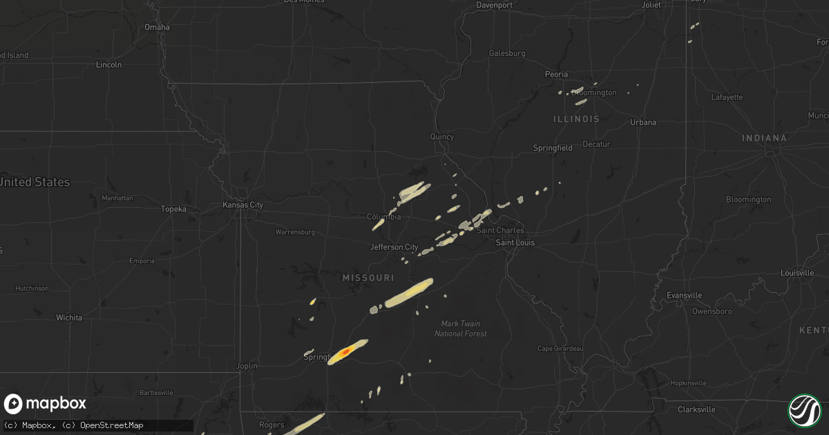
Hail Map in Texas on April 10, 2011
Get this storm
April 10 map
$229
one time, instant access
Download today. No call, no setup
Keep the $229
Bought the map and want the full workflow? Apply the entire $229 to a subscription within 7 days. None of it is wasted.
Every map, not just this one
This buys you this map. Subscription and you get every map we run, in the markets you choose from a few cities to whole states to nationwide. Plus real-time alerts the moment a storm fires.
Contact data
Name, contact info, occupancy, even credit band for addresses in the footprint. You go from where it hit to who to call.
Become the source they trust
Unlimited branding weather history reports on demand. You already have the documented answer ready for the property owner, and you are the one who showed up with it.
Property data and RoofTrace estimates
Pull up any address you have got, its value and the exact code rules for that jurisdiction, straight from One Click Code. Then RoofTrace estimates the squares, pitch, and roof value, priced the way you price.
Storm reports in Texas
Texas
| Date | Description |
|---|---|
| 04/10/20115:05 AM CDT | 15 foot section of sturdy wooden fence blown down along with a couple of 5 inch plus diameter tree branches |
| 04/10/20114:45 AM CDT | Penny hail increased to quarter size hail |
| 04/10/20113:55 AM CDT | Trees down on highway 44 south of annona. |
| 04/10/20113:45 AM CDT | Trees down across much of the county. |
| 04/10/20113:10 AM CDT | Trees down on fm 17 and also on cr 1912. |
| 04/10/20113:05 AM CDT | Large tree down on powerlines on reservoir st. In sulphur springs. |
| 04/10/20112:30 AM CDT | Widespread wind damage in the southern part of the county. Numerous trees...powerlines and structures damaged. |
| 04/10/20112:30 AM CDT | Numerous roofs off of houses and 2 houses almost destroyed. Possible tornado damage in a defined 1/2 mile wide swath. |
| 04/10/20112:20 AM CDT | Measured at school site |
| 04/10/20112:15 AM CDT | Roof blown off house near 205 just north of terrell. Nermerous trees down as well. |
| 04/10/20112:15 AM CDT | Large trees and powerlines down in crandall |
| 04/10/20112:13 AM CDT | An ef1 tornado occurred in the northern portions of forney near the intersection of fm 740 and lovers lane. Five homes sustained roof damage. This tornado was 60 yards |
| 04/10/20112:11 AM CDT | Near rowlett rd. And lakeview pkwy. |
| 04/10/20112:06 AM CDT | Carports collapsed...business signs down and 1ft diameter tree down |
| 04/10/20111:57 AM CDT | Measured at kjwy |
| 04/10/20111:55 AM CDT | A local report indicates 75 MPH wind near 2 S LANCASTER |
| 04/10/20111:51 AM CDT | Possible tornado according to spotter |
| 04/10/20111:50 AM CDT | 1ft diameter tree leaning on house and 2ft diameter tree blocking fm 875...just west of lone elm. |
| 04/10/20111:48 AM CDT | Damage to comfort suites on us 287 and east of i35...north of waxahachie. Time estimated from radar |
| 04/10/20111:43 AM CDT | Waxahachie |
| 04/10/20111:39 AM CDT | Broken glass due to estimated 65 mph winds |
| 04/10/20111:36 AM CDT | Alvarado - measured from school site |
| 04/10/20111:35 AM CDT | 6-12 inch diameter limbs down near fm 2738 and hwy 67 |
| 04/10/20111:32 AM CDT | Near rowlett rd. And lakeview pkwy. |
| 04/10/20111:32 AM CDT | Mansfield |
| 04/10/20111:32 AM CDT | Two mobile homes damage and 3 single family residences sustained roof damage. |
| 04/10/20111:30 AM CDT | Two mobile homes and and one single family home with roof damage. |
| 04/10/20111:30 AM CDT | Several 1 foot diameter trees were down...wooden playground was turned over and lots of debris on the ground. |
| 04/10/20111:26 AM CDT | 67 mph winds and power outages in sand |
| 04/10/20111:25 AM CDT | Near bonham |
| 04/10/20111:25 AM CDT | Large tree down |
| 04/10/20111:23 AM CDT | Burleson |
| 04/10/20111:23 AM CDT | Straight line winds resulted in the collapse of a wall of the medicine chest pharmacy near north cummings dr and highway 67. Sign and power pole damage was also noted i |
| 04/10/20111:22 AM CDT | An ef1 tornado was confirmed in alvarado by a nws storm survey. A mobile home was overturned resulting in two minor injuries. The equine vet building was damaged and fo |
| 04/10/20111:11 AM CDT | 1 foot diameter tree down off beach street north of i-820 in north fort worth |
| 04/10/20111:09 AM CDT | An ef1 tornado occurred 4 miles northwest of rio vista and traveled east approximately 1.5 miles. A garage was damaged and a house was shifted off its foundation near t |
| 04/10/20111:08 AM CDT | Several trees down in blum |
| 04/10/20111:06 AM CDT | One very large barn was destroyed. |
| 04/10/201112:56 AM CDT | A home in clifton was damaged by a falling tree. Multiple trees and power poles were down across the county. |
| 04/10/201112:55 AM CDT | A concession stand was blown into the road at highway 56 and highway 174 in kopperl. |
| 04/10/201112:55 AM CDT | A local report indicates 60 MPH wind near 5 W LLANO |
| 04/10/201112:54 AM CDT | Glass broken at a bank |
| 04/10/201112:54 AM CDT | 80 mph winds with numerous power poles down |
| 04/10/201112:37 AM CDT | Damage to windows...cars and trees |
| 04/10/201112:35 AM CDT | A local report indicates 64 MPH wind near HAMILTON |
| 04/10/201112:34 AM CDT | Prosper |
| 04/10/201112:29 AM CDT | Golfball hail reported at hwy 380 and fm 720 |
| 04/10/201112:25 AM CDT | 3/4 mile north of hwy 380 and paloma creek blvd. |
| 04/10/201112:25 AM CDT | Roof/structural dmg 3/4 mile north of hwy 380 and paloma creek blvd. |
| 04/10/201112:15 AM CDT | A local report indicates 1.75 inch wind near POTTSVILLE |
| 04/10/201112:15 AM CDT | A local report indicates 80 MPH wind near POTTSVILLE |
| 04/10/201112:15 AM CDT | Near i35 and mayhill rd. |
| 04/10/201112:05 AM CDT | Corinth |
| 04/10/201112:05 AM CDT | Corinth |
| 04/10/201112:04 AM CDT | Wind damage reported at texas motor speedway. Signs...fences...and flag poles damaged by strong winds. Numerous temporary structures...including trailers...rvs...and ta |
| 04/10/201112:02 AM CDT | Several windows blown out of houses...minor roof damage and several large trees were blocking roads. |
| 04/10/201112:02 AM CDT | A local report indicates 1.75 inch wind near PRIDDY |
| 04/09/201111:55 PM CDT | 65 to 70 mph estimated. Limbs down. |
| 04/09/201111:51 PM CDT | 2 large trees were blown down and had to be removed after blocking fm 573 near mullin. |
| 04/09/201111:45 PM CDT | Roof blown off of barn. |
| 04/09/201111:35 PM CDT | 1.00 inch hail reported 5 n of richland springs. |
| 04/09/201111:15 PM CDT | A local report indicates 1.00 inch wind near 19 E SONORA |
| 04/09/201111:09 PM CDT | A local report indicates 60 MPH wind near LOHN |
| 04/09/201111:00 PM CDT | A local report indicates 1.75 inch wind near 5 E MENARD |
| 04/09/201111:00 PM CDT | A local report indicates 1.75 inch wind near 10 SE MENARD |
| 04/09/201110:50 PM CDT | Estimated at montague sheriff department |
| 04/09/201110:45 PM CDT | Roof damage on barn. Wind speed estimated 60 mph or more. Small hail less than 1 inch. |
| 04/09/201110:37 PM CDT | A local report indicates 1.75 inch wind near FORT MCKAVETT |
| 04/09/201110:30 PM CDT | A local report indicates 1.00 inch wind near COLEMAN |
| 04/09/201110:17 PM CDT | A local report indicates 1.75 inch wind near LAKE WORTH |
| 04/09/201110:11 PM CDT | A local report indicates 1.25 inch wind near BOWIE |
| 04/09/201110:10 PM CDT | A local report indicates 1.75 inch wind near BOWIE |
| 04/09/201110:05 PM CDT | Trees and limbs of varying sizes were down in and around deleon |
| 04/09/201110:00 PM CDT | A local report indicates 1.00 inch wind near 2 NW ELDORADO |
| 04/09/20119:45 PM CDT | Dime to quarter hail |
| 04/09/20119:00 PM CDT | 1 hail reported at hords creek reservoir 8 miles wnw of coleman at 8...50pm |
| 04/09/20118:50 PM CDT | 1 inch hail reported at hoards creek reservoir 8 miles wnw of coleman at 850pm |
| 04/09/20118:50 PM CDT | 1 hail reported at hords creek reservoir 8 miles wnw of coleman at 850pm |
| 04/09/20117:53 PM CDT | Pioneer. 4 west rising star. Time estimated from radar |
All States Impacted by Hail Map on April 10, 2011
Cities Impacted by Hail Map on April 10, 2011
- New London, WI
- Hortonville, WI
- Doss, TX
- Del Rio, TX
- Ozona, TX
- Eldorado, TX
- High Bridge, WI
- Deer River, MN
- Christoval, TX
- Mason, TX
- Melvin, TX
- Voca, TX
- Menard, TX
- Hext, TX
- Brady, TX
- Hatfield, AR
- Mena, AR
- Friendship, WI
- Adams, WI
- Aubrey, TX
- Fort Worth, TX
- Celina, TX
- Whitewright, TX
- Roanoke, TX
- Azle, TX
- Pilot Point, TX
- Savoy, TX
- Ravenna, TX
- Frisco, TX
- Ector, TX
- Justin, TX
- Little Elm, TX
- Argyle, TX
- Mckinney, TX
- Denton, TX
- Dodd City, TX
- Anna, TX
- Newark, TX
- Ivanhoe, TX
- Van Alstyne, TX
- Bonham, TX
- Haslet, TX
- Lake Dallas, TX
- Prosper, TX
- Telephone, TX
- Hamilton, TX
- Fayetteville, AR
- Prairie Grove, AR
- Warner, OK
- Winslow, AR
- Canehill, AR
- Evansville, AR
- Eufaula, OK
- Uniontown, AR
- Porum, OK
- West Fork, AR
- Chester, AR
- Natural Dam, AR
- Elkins, AR
- Vian, OK
- Webbers Falls, OK
- Gore, OK
- Bunch, OK
- Stilwell, OK
- Checotah, OK
- Sallisaw, OK
- Ontonagon, MI
- Caddo, OK
- Gainesville, TX
- Muenster, TX
- Carlinville, IL
- Brixey, MO
- Graford, TX
- Palo Pinto, TX
- Mineral Wells, TX
- Perrin, TX
- Elizabeth, IL
- Stockton, IL
- Caney, OK
- Elk Mound, WI
- Durand, WI
- Menomonie, WI
- Colfax, WI
- Chippewa Falls, WI
- Mondovi, WI
- Bloomer, WI
- Reedsburg, WI
- La Valle, WI
- Lyndon Station, WI
- Mauston, WI
- Watson, OK
- Santa Anna, TX
- Cranfills Gap, TX
- Brownwood, TX
- Comanche, TX
- Early, TX
- Priddy, TX
- Lohn, TX
- Jonesboro, TX
- Iredell, TX
- Pottsville, TX
- Voss, TX
- Morgan, TX
- Brookesmith, TX
- Clifton, TX
- Carlton, TX
- Millersview, TX
- Doole, TX
- Mullin, TX
- Zephyr, TX
- Richland Springs, TX
- Meridian, TX
- Goldthwaite, TX
- Rochelle, TX
- Rockwood, TX
- Gustine, TX
- Eden, TX
- Hico, TX
- Gouldbusk, TX
- Lime Springs, IA
- Cresco, IA
- Ashland, WI
- Millsap, TX
- Weatherford, TX
- Wautoma, WI
- Dublin, TX
- Wright City, MO
- Spring Lake, MN
- Talmoon, MN
- Junction, TX
- Ardmore, OK
- Sonora, TX
- Spruce, MI
- Lincoln, MI
- Barton City, MI
- Ponca, AR
- Comins, MI
- Lewiston, MI
- De Leon, TX
- Gorman, TX
- Arcadia, WI
- Rocksprings, TX
- Muldrow, OK
- Bay City, WI
- Hager City, WI
- Red Wing, MN
- Empire, MI
- Weyerhaeuser, WI
- New Auburn, WI
- Chetek, WI
- Itasca, TX
- Whitney, TX
- Hillsboro, TX
- Hilbert, WI
- Rogersville, MO
- Seymour, MO
- Hartville, MO
- Grovespring, MO
- Fordland, MO
- Niangua, MO
- Ozark, MO
- Marshfield, MO
- Strafford, MO
- Springfield, MO
- Wickes, AR
- Cove, AR
- Plano, TX
- Rising Star, TX
- Carbon, TX
- Cross Plains, TX
- Houston, MN
- Hubbard Lake, MI
- Curran, MI
- Black River, MI
- Lachine, MI
- Harrisville, MI
- Westville, OK
- Oark, AR
- San Saba, TX
- Jim Falls, WI
- Vichy, MO
- Rolla, MO
- Stonewall, OK
- Grand Prairie, TX
- Cookson, OK
- Wesley, AR
- Stigler, OK
- Cedarville, AR
- Osseo, WI
- Jamestown, MO
- Columbia, MO
- Paradise, TX
- Boyd, TX
- Springtown, TX
- Caledonia, MN
- Bad Axe, MI
- Elkton, MI
- Harbor Beach, MI
- Filion, MI
- Port Hope, MI
- Old Monroe, MO
- Brussels, IL
- Batchtown, IL
- Winfield, MO
- Foley, MO
- Arlington, TX
- Kennedale, TX
- Mansfield, TX
- San Angelo, TX
- Vancourt, TX
- Holcombe, WI
- Ladysmith, WI
- Bruce, WI
- Wheeler, WI
- Ridgeland, WI
- Locust Grove, AR
- Concord, AR
- Floral, AR
- Batesville, AR
- Mexico, MO
- Centralia, MO
- Thompson, MO
- Tremont, IL
- Eagletown, OK
- Broken Bow, OK
- Berger, MO
- Chilton, TX
- Ada, OK
- La Crescent, MN
- West Salem, WI
- La Crosse, WI
- Hokah, MN
- Brownsville, MN
- Boyceville, WI
- Cornell, WI
- Eau Galle, WI
- Willow Springs, MO
- Port Austin, MI
- Merkel, TX
- Gordon, TX
- Ranger, TX
- Lipan, TX
- Mingus, TX
- Santo, TX
- Bluff Dale, TX
- Aledo, TX
- Rock Falls, IL
- Winona, MN
- Fountain City, WI
- Dodge, WI
- Decatur, TX
- Tuscola, TX
- Ruth, MI
- Owendale, MI
- Pigeon, MI
- Sebewaing, MI
- Bay Port, MI
- Laona, WI
- Crandon, WI
- Argonne, WI
- Thackerville, OK
- Whitesboro, TX
- Gordonville, TX
- Lindsay, TX
- Locust Grove, OK
- Grand Portage, MN
- Hovland, MN
- Wilburton, OK
- Red Oak, OK
- Cashton, WI
- Coon Valley, WI
- Westby, WI
- Marcell, MN
- Bigfork, MN
- Hayward, WI
- Tomah, WI
- Cook, MN
- May, TX
- Coleman, TX
- Burkett, TX
- Holdenville, OK
- Round Rock, TX
- Bowie, TX
- Sunset, TX
- Butternut, WI
- Osseo, MI
- South Range, WI
- Superior, WI
- Potter, WI
- Reedsville, WI
- Brillion, WI
- Ely, MN
- Farmington, AR
- Lincoln, AR
- Proctor, OK
- Park Hill, OK
- Summers, AR
- Welling, OK
- Springdale, AR
- Marietta, OK
- Overbrook, OK
- Honey Grove, TX
- Valley Spring, TX
- Llano, TX
- Elmwood, WI
- Ellsworth, WI
- Foristell, MO
- Dorchester, WI
- Menasha, WI
- Appleton, WI
- Neenah, WI
- Alvord, TX
- Burleson, TX
- Cedar Hill, TX
- Trenton, TX
- Crowley, TX
- Tolar, TX
- Castell, TX
- Naval Air Station Jrb, TX
- Montague, TX
- Art, TX
- Tioga, TX
- Cleburne, TX
- Sumner, TX
- Granbury, TX
- Whitt, TX
- London, TX
- Desdemona, TX
- Boswell, OK
- Blanket, TX
- Dallas, TX
- Cisco, TX
- Lewisville, TX
- Gunter, TX
- Godley, TX
- Bells, TX
- Ponder, TX
- Saint Jo, TX
- Tom Bean, TX
- Desoto, TX
- Denison, TX
- Chico, TX
- Sherman, TX
- Lillian, TX
- Fort McKavett, TX
- Eastland, TX
- Stephenville, TX
- Cresson, TX
- Jacksboro, TX
- Blum, TX
- Joshua, TX
- Bridgeport, TX
- Hugo, OK
- Valera, TX
- Soper, OK
- Venus, TX
- Strawn, TX
- Bennington, OK
- Alvarado, TX
- Evant, TX
- Paint Rock, TX
- Duncanville, TX
- Krum, TX
- Flower Mound, TX
- Talpa, TX
- Rhome, TX
- Forestburg, TX
- Howe, TX
- Midlothian, TX
- Collinsville, TX
- Nocona, TX
- Sadler, TX
- Pottsboro, TX
- Austin, TX
- Onalaska, WI
- Hermann, MO
- Mill Creek, OK
- Mannsville, OK
- Valley Mills, TX
- Collins, WI
- Chilton, WI
- Georgetown, TX
- Roff, OK
- Fitzhugh, OK
- Ladonia, TX
- Kewaunee, WI
- Denmark, WI
- Wild Rose, WI
- Kalkaska, MI
- New London, MO
- Chouteau, OK
- Grayling, MI
- Two Rivers, WI
- Mishicot, WI
- Newton, WI
- Manitowoc, WI
- Sasakwa, OK
- Atwood, OK
- Wewoka, OK
- Marthasville, MO
- Warrenton, MO
- Harper, TX
- Mountain Home, TX
- Oshkosh, WI
- Allen, OK
- Hanna, OK
- Maud, OK
- Lamar, OK
- Konawa, OK
- Wetumka, OK
- Calvin, OK
- Dustin, OK
- Stuart, OK
- Asher, OK
- Mcalester, OK
- Burnet, TX
- Lampasas, TX
- Tahlequah, OK
- Rogers, AR
- Berryville, AR
- Braggs, OK
- Huntsville, AR
- Green Forest, AR
- Muskogee, OK
- Omaha, AR
- Hindsville, AR
- Eureka Springs, AR
- Ontario, WI
- Rhinelander, WI
- Pelican Lake, WI
- Okemah, OK
- Casco, WI
- Algoma, WI
- Alpena, MI
- South Branch, MI
- Fairview, MI
- Herron, MI
- Nemo, TX
- Kopperl, TX
- Maiden Rock, WI
- Spring Valley, WI
- Jerseyville, IL
- Fremont, WI
- Larsen, WI
- Medford, WI
- Fife Lake, MI
- Harmony, MN
- Linn, MO
- Perry, MO
- Laddonia, MO
- Santa Fe, MO
- Warrens, WI
- Athens, WI
- Seymour, TX
- Max, MN
- Whitehall, WI
- Almond, WI
- Winneconne, WI
- Greenville, WI
- Bangor, WI
- Redgranite, WI
- Kendall, WI
- Coloma, WI
- Weyauwega, WI
- Rockland, WI
- Kimberly, WI
- Poy Sippi, WI
- Genoa, WI
- Viroqua, WI
- Plainfield, WI
- Pine River, WI
- Necedah, WI
- Waupaca, WI
- Arkdale, WI
- Sparta, WI
- Stoddard, WI
- Nekoosa, WI
- Canton, MN
- Chaseburg, WI
- Camp Douglas, WI
- Decorah, IA
- Bancroft, WI
- Wilton, WI
- New Lisbon, WI
- Mabel, MN
- Grand Marsh, WI
- Spring Grove, MN
- Hancock, WI
- Norwalk, WI
- Shiocton, WI
- Cape Vincent, NY
- Blanco, OK
- Pittsburg, OK
- Rush Hill, MO
- Troy, MO
- Truesdale, MO
- Wentzville, MO
- Edgar, WI
- Colby, WI
- Abbotsford, WI
- Maribel, WI
- Saint James, MO
- Owensville, MO
- Waynesville, MO
- Richland, MO
- Jerome, MO
- Dixon, MO
- Bland, MO
- Belle, MO
- Newburg, MO
- Crocker, MO
- Saint Robert, MO
- Irma, WI
- Merrill, WI
- Sulphur, OK
- Weaubleau, MO
- Wheatland, MO
- Mellen, WI
- New Florence, MO
- Montgomery City, MO
- Stringtown, OK
- Daisy, OK
- Hartshorne, OK
- Tuskahoma, OK
- Hallsville, MO
- Stanley, WI
- Augusta, WI
- Cadott, WI
- Boyd, WI
- Fall Creek, WI
- Sturgeon Bay, WI
- Thornfield, MO
- Noble, MO
- Wasola, MO
- Park Falls, WI
- Johannesburg, MI
- Gaylord, MI
- Atlanta, MI
- Homer, MI
- Elcho, WI
- Gleason, WI
- Boynton, OK
- Hendrix, OK
- Colbert, OK
- Luxemburg, WI
- Nilwood, IL
- Maypearl, TX
- Grandview, TX
- Fredericksburg, TX
- Rib Lake, WI
- Mounds, OK
- Leon, OK
- Green Lake, WI
- Hutto, TX
- Stoutland, MO
- Covington, TX
- Rio Vista, TX
- Peterson, MN
- Francis Creek, WI
- Pittsfield, IL
- Taylor, TX
- Winters, TX
- Rushford, MN
- New Haven, MO
- South Boardman, MI
- Burneyville, OK
- Downing, WI
- Knapp, WI
- Bellflower, MO
- Silex, MO
- Truxton, MO
- Wakefield, MI
- Hopedale, IL
- Pettigrew, AR
- Honor, MI
- De Pere, WI
- Greenleaf, WI
- Green Bay, WI
- Grafton, IL
- Fieldon, IL
- Bena, MN
- Liberty Hill, TX
- Beulah, MI
- Richland Center, WI
- Ash Grove, MO
- Willard, MO
- Bois D Arc, MO
- Stanford, IL
- Mackinaw, IL
- Minier, IL
- Danvers, IL
- Westphalia, MO
- Bowling Green, MO
- Middletown, MO
- Hillman, MI
- Kempner, TX
- Eau Claire, WI
- Wonewoc, WI
- Tekonsha, MI
- Lebanon, MO
- Clam Lake, WI
- Orr, MN
- Keene, TX
- Pickett, WI
- Windom, TX
- Drury, MO
- Gans, OK
- Turner, MI
- Omer, MI
- Standish, MI
- Au Gres, MI
- Freeburg, MO
- Koeltztown, MO
- Rattan, OK
- Mccurtain, OK
- Shady Point, OK
- Bokoshe, OK
- Colon, MI
- Sherwood, MI
- Cedar Park, TX
- Vandalia, MO
- Marengo, WI
- Mason, WI
- Whitelaw, WI
- Hillsdale, MI
- Kiel, WI
- Bokchito, OK
- Gilman, WI
- Chamois, MO
- Morrison, MO
- Keota, OK
- Cazenovia, WI
- Melvin, IL
- Glen Rose, TX
- Dorchester, IA
- Eitzen, MN
- Neshkoro, WI
- Bristow, OK
- Calmar, IA
- La Pointe, WI
- Granger, TX
- Mountainburg, AR
- Gibson City, IL
- Freeport, IL
- Eleva, WI
- Massena, NY
- Byers, TX
- Greenville, TX
- Atoka, OK
- Kenefic, OK
- Charles City, IA
- Alta Vista, IA
- Sidney, TX
- Tomahawk, WI
- Nelson, WI
- Wilson, WI
- Alma, AR
- Mulberry, AR
- Owen, WI
- Thorp, WI
- Withee, WI
- Curtiss, WI
- Fifield, WI
- Phillips, WI
- Lake Village, IN
- Alma, WI
- Roxton, TX
- Fairchild, WI
- Leander, TX
- Lowell, IN
- Saxon, WI
- Dripping Springs, TX
- Sulphur Springs, TX
- Bear Lake, MI
- Benzonia, MI
- Thompsonville, MI
- Ballinger, TX
- Garland, TX
- Spiro, OK
- Horseshoe Bay, TX
- Willow City, TX
- Round Mountain, TX
- Wagoner, OK
- Moscow Mills, MO
- O'Fallon, MO
- Princeton, WI
- Desha, AR
- Frankford, MO
- Louisiana, MO
- Mancelona, MI
- Frederic, MI
- Theodosia, MO
- Strum, WI
- Lublin, WI
- Stetsonville, WI
- Steelville, MO
- Roosevelt, TX
- Kellogg, MN
- Ozark, AR
- Wilson, OK
- Sanger, TX
- Manton, MI
- Kingsley, MI
- Mukwonago, WI
- Durant, OK
- Blair, WI
- Independence, WI
- New Berlin, WI
- Waukesha, WI
- Eagle, WI
- Marble Falls, TX
- Bayfield, WI
- Mendon, MI
- Hawkins, WI
- Wabasha, MN
- Rock City, IL
- Pearl City, IL
- Ridott, IL
- Dakota, IL
- Royse City, TX
- Harvel, IL
- Dryden, TX
- Ironwood, MI
- Burlington, MI
- Stamford, TX
- Camden, MI
- Smithville, OK
- Wichita Falls, TX
- Buchanan Dam, TX
- Bangs, TX
- Medora, IL
- Piasa, IL
- Fidelity, IL
- Campbell, TX
- Ringling, OK
- Winter, WI
- Hillsboro, WI
- Hudson, IL
- Twining, MI
- Lewiston, MN
- Mio, MI
- Roscommon, MI
- Hillpoint, WI
- Loganville, WI
- Brussels, WI
- Melissa, TX
- Rudy, AR
- Southlake, TX
- Altoona, WI
- Reads Landing, MN
- Unity, WI
- McLean, IL
- Armington, IL
- Rosston, TX
- Elma, IA
- Edgar Springs, MO
- Montello, WI
- Hawk Point, MO
- Eminence, MO
- Black Creek, WI
- Little Chute, WI
- Omro, WI
- Berlin, WI
- Ridgeway, IA
- Walnut Springs, TX
- Ironton, MO
- Fredericktown, MO
- Arcadia, MO
- Sharon, WI
- Fair Play, MO
- Beggs, OK
- Tower, MN
- Angora, MN
- Bartlett, TX
- Quinlan, TX
- Dunnegan, MO
- Bolivar, MO


