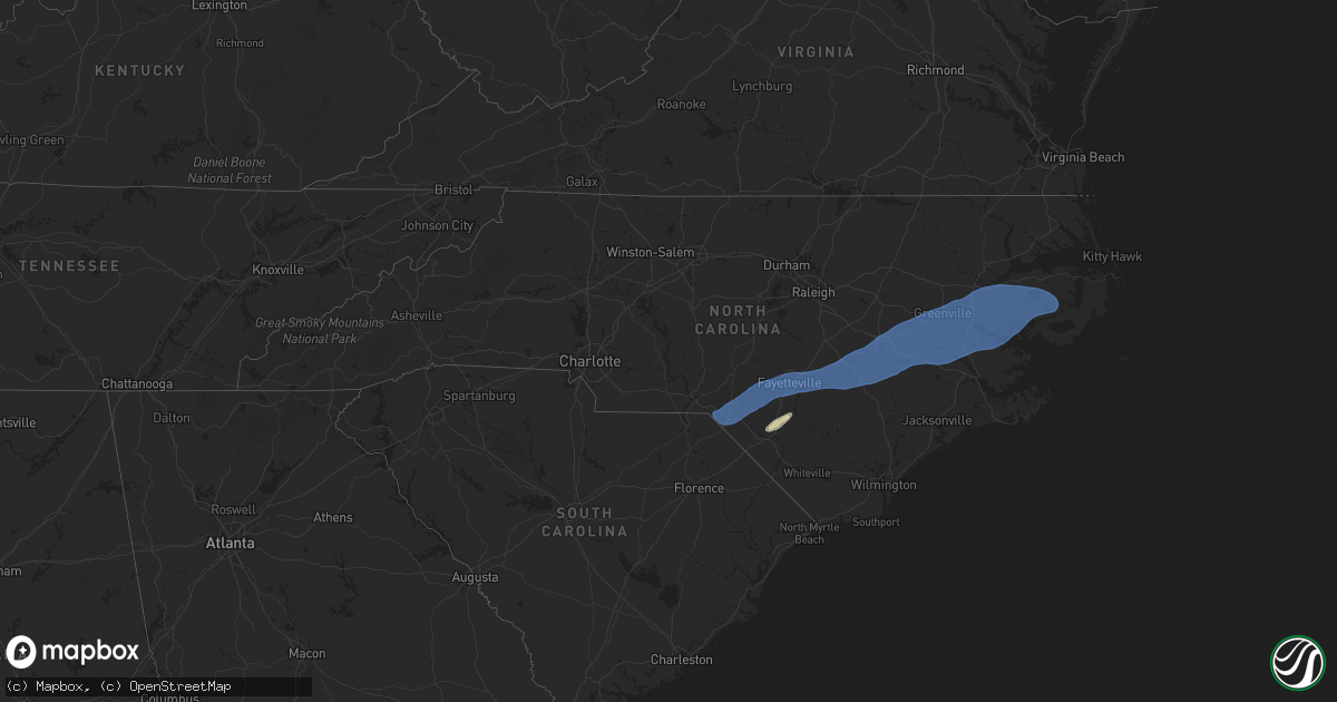
Hail Map in North Carolina on April 7, 2025
Get this storm
April 7 map
$229
one time, instant access
Download today. No call, no setup
Keep the $229
Bought the map and want the full workflow? Apply the entire $229 to a subscription within 7 days. None of it is wasted.
Every map, not just this one
This buys you this map. Subscription and you get every map we run, in the markets you choose from a few cities to whole states to nationwide. Plus real-time alerts the moment a storm fires.
Contact data
Name, contact info, occupancy, even credit band for addresses in the footprint. You go from where it hit to who to call.
Become the source they trust
Unlimited branding weather history reports on demand. You already have the documented answer ready for the property owner, and you are the one who showed up with it.
Property data and RoofTrace estimates
Pull up any address you have got, its value and the exact code rules for that jurisdiction, straight from One Click Code. Then RoofTrace estimates the squares, pitch, and roof value, priced the way you price.
Storm reports in North Carolina
North Carolina
| Date | Description |
|---|---|
| 04/07/20253:35 PM CDT | Multiple power outages due to thunderstorm wind damage in pinetown. |
| 04/07/20253:32 PM CDT | Duke/progress energy reports power outages caused by fallen trees or limbs damaging their equipment. Time estimated based on radar data. |
| 04/07/20253:18 PM CDT | Trees down on boyds road near blackjack. |
| 04/07/20253:05 PM CDT | Tree on house in the city of greenville. |
| 04/07/20253:05 PM CDT | Trees down on davenport farm road. |
| 04/07/20253:05 PM CDT | Multiple trees down on carson edwards road near highway 903. |
| 04/07/20253:05 PM CDT | Trees down on belvoir highway. |
| 04/07/20253:04 PM CDT | Spotter estimated golf-ball sized hail in greenville. |
| 04/07/20253:04 PM CDT | Delayed report. Power lines down on tucker road. |
| 04/07/20252:59 PM CDT | Delayed report. Tree on power line on contentnea lane. |
| 04/07/20252:55 PM CDT | Trees and wires down along ormondsville road. |
| 04/07/20252:42 PM CDT | Medium sized chain link cage blown over. Time estimated from radar. Report and picture via facebook. |
| 04/07/20252:35 PM CDT | Over 600 power outages reported by duke energy in new hope due to trees down. Time estimated based on radar. |
| 04/07/20252:30 PM CDT | Trees down along jones turner road blocking one lane. |
| 04/07/20252:27 PM CDT | Trees down along highway 403 near shelton road. |
| 04/07/20252:25 PM CDT | Multiple reports of trees and powerlines down in the southwestern and southern parts of wayne county... Especially in the grantham... Dudley and mar mac communities. 25 |
| 04/07/20252:23 PM CDT | Tree down intersection highway 117 and tom hill road... Blocking one lane. |
| 04/07/20252:23 PM CDT | Multiple reports of trees down on roads... Powerlines... And railroad tracks in the faison area. |
| 04/07/20252:23 PM CDT | Tree down on house. |
| 04/07/20252:20 PM CDT | Awos station kw40 2 ene mount olive. |
| 04/07/20252:20 PM CDT | Delayed report. Large tree down on a home on juniper road. Report via facebook. |
| 04/07/20252:20 PM CDT | Delayed report. The roof was partially torn off the old piggly wiggly in town. Report via facebook. |
| 04/07/20252:00 PM CDT | Video of multiple trees falling in neighborhood in roseboro... Nc from social media. Time estimated from radar. |
| 04/07/20251:56 PM CDT | Tree down along tolarsville rd. |
| 04/07/20251:55 PM CDT | A large limb...12-18 inches in diameter fell off a gum tree knocking out service to an outdoor light. |
| 04/07/20251:50 PM CDT | Tree down along community rd. |
| 04/07/20251:38 PM CDT | Tree down at mary c rd. |
| 04/07/20251:37 PM CDT | Asos station kfay fayetteville. |
| 04/07/20251:35 PM CDT | A large limb...12-18 inches in diameter fell off a gum tree knocking out service to an outdoor light. Time updated based on radar. |
| 04/07/20251:35 PM CDT | Power lines down on green pasture road near rocky mount. Time estimated by radar. |
| 04/07/20251:33 PM CDT | Several trees down at an office in hope mills. Time estimated based on radar. |
| 04/07/20251:32 PM CDT | Tree down blocking the roadway at 1311 kehukee church rd. |
| 04/07/20251:31 PM CDT | Several hundred power outages due to downed trees just southeast of hope mills. |
| 04/07/20251:10 PM CDT | Asos station kmeb maxton. |
| 04/07/20251:00 PM CDT | 7 large trees and a few powerlines down blocking roads in the laurel hill area. |
| 04/06/20257:50 PM CDT | A local report indicates 1.00 inch wind near 5 WSW Jerome |
All States Impacted by Hail Map on April 7, 2025
Cities Impacted by Hail Map on April 7, 2025
- Ochlocknee, GA
- Meigs, GA
- Tallahassee, FL
- Eastpoint, FL
- Carrabelle, FL
- Lanark Village, FL
- Sopchoppy, FL
- Panacea, FL
- Raeford, NC
- Parkton, NC
- Lumber Bridge, NC
- Hope Mills, NC
- Red Springs, NC
- Shannon, NC
- Fayetteville, NC
- Stedman, NC
- Autryville, NC
- Wade, NC
- Godwin, NC
- Roseboro, NC
- Salemburg, NC
- Maxton, NC
- Laurinburg, NC
- Wagram, NC
- Gibson, NC
- Laurel Hill, NC
- Clinton, NC
- Marston, NC
- Dunn, NC
- Newton Grove, NC
- Faison, NC
- Mount Olive, NC
- Dudley, NC
- Calypso, NC
- Warsaw, NC
- Turkey, NC
- Seven Springs, NC
- Deep Run, NC
- Albertson, NC
- Kinston, NC
- La Grange, NC
- Goldsboro, NC
- Snow Hill, NC
- Four Oaks, NC
- Pikeville, NC
- Stantonsburg, NC
- Walstonburg, NC
- Farmville, NC
- Greenville, NC
- Ayden, NC
- Hookerton, NC
- Grifton, NC
- Winterville, NC
- Stokes, NC
- Grimesland, NC
- Dover, NC
- Trenton, NC
- Cove City, NC
- Vanceboro, NC
- Washington, NC
- Ernul, NC
- New Bern, NC
- Chocowinity, NC
- Blounts Creek, NC
- Williamston, NC
- Jamesville, NC
- Belhaven, NC
- Plymouth, NC
- Aurora, NC
- Pantego, NC
- Pinetown, NC
- Edward, NC
- Bath, NC
- Scranton, NC
- Roper, NC
- Windsor, NC
- Creswell, NC
- Columbia, NC
- Pendleton, OR
- Echo, OR
- Lumberton, NC
- Saint Pauls, NC


