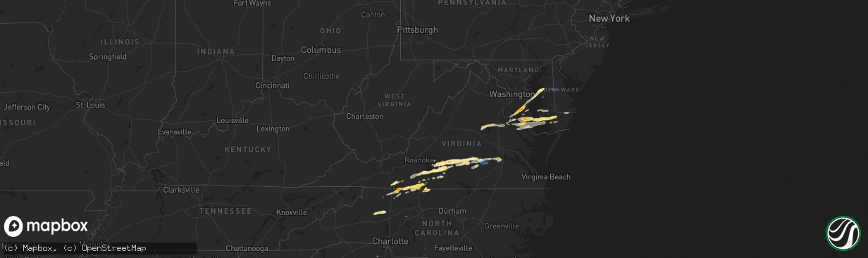
Hail Map in Virginia on April 6, 2023
The weather event in Virginia on April 6, 2023 includes Hail, Wind, and Tornado maps. 10 states and 199 cities were impacted and suffered possible damage. The total estimated number of properties impacted is 30,901.
Want more than just the map?
Turn this storm into a full workflow.
- Owner + property data so you know who to knock
- OnDemand branded weather history reports to win the "did we even have hail?" argument
- RoofTrace estimate so reps stop guessing numbers at the door
Bought this map? Upgrade within 7 days and we'll credit the $230. (10-15 min setup call)
Hail
Wind
Tornado
30,901
Estimated number of impacted properties by a 1.00" hail or larger8,293
Estimated number of impacted properties by a 1.75" hail or larger1,915
Estimated number of impacted properties by a 2.50" hail or largerStorm reports in Virginia
Virginia
| Date | Description |
|---|---|
| 04/06/20236:10 PM CDT | Time estimated by radar. |
| 04/06/20236:05 PM CDT | Several trees down across southern chesterfield county. One tree damaged a home. |
| 04/06/20236:03 PM CDT | Thunderstorm winds blew down one tree along the 2000 block of wooding road. |
| 04/06/20236:00 PM CDT | A few power outages due to storm north of callao. Time estimated. |
| 04/06/20235:55 PM CDT | Trees down across southern chesterfield county. |
| 04/06/20235:25 PM CDT | M-ping report of trees and branches down around mcclean. |
| 04/06/20235:20 PM CDT | Tree downed on route 614. Time estimated from radar. |
| 04/06/20235:18 PM CDT | Over 100 power outages due to storm just to the north of amelia court house. Time estimated. |
| 04/06/20235:11 PM CDT | Trees snapped and uprooted at a residence. |
| 04/06/20235:06 PM CDT | Several trees down. Time estimated from radar data. |
| 04/06/20235:04 PM CDT | Multiple trees down near the intersection of route 360 and route 307 southwest of jetersville. Time estimated from radar data. |
| 04/06/20235:04 PM CDT | A local report indicates 1.00 inch wind near JETERSVILLE |
| 04/06/20234:54 PM CDT | A local report indicates 1.75 inch wind near 3 N RIDGEWAY |
| 04/06/20234:51 PM CDT | Thunderstorm winds blew down one tree along the intersection of greensboro road and lee ford camp road. |
| 04/06/20234:42 PM CDT | Over 700 power outages due to storm from hampden sydney to warsham. Time estimated. |
| 04/06/20234:33 PM CDT | Over 200 power outages likely due to storm near i-95 in northern caroline county. Time estimated. |
| 04/06/20234:30 PM CDT | Half dollar size hail at the lowes in farmville. Report relayed by nws rnk. |
| 04/06/20234:30 PM CDT | Several trees down and some wind damage at the prince edward county courthouse in farmville. Time estimated. |
| 04/06/20234:29 PM CDT | Report from mping: quarter |
| 04/06/20234:20 PM CDT | Report relayed from wsls-tv. |
| 04/06/20234:17 PM CDT | Multiple trees down near the 3000 block of partlow road |
| 04/06/20234:10 PM CDT | Reported by trained spotter. |
| 04/06/20234:10 PM CDT | Corrects hail size from previous hail report in five forks. |
| 04/06/20234:10 PM CDT | Power outages likely due to storm on winston road in northern louisa county. Time estimated. |
| 04/06/20234:10 PM CDT | A local report indicates 1.00 inch wind near FIVE FORKS |
| 04/06/20234:09 PM CDT | Report from waller road. |
| 04/06/20234:09 PM CDT | Hail slightly larger than golfball size. Windshields shattered in at least 2 vehicles and damage to roof. |
| 04/06/20234:08 PM CDT | Tree down just east of pamplin. |
| 04/06/20234:07 PM CDT | Thunderstorm winds blew down one tree that fell into a house along the 600 block of old well road. |
| 04/06/20233:59 PM CDT | Personal weather station kvaspots70 |
| 04/06/20233:50 PM CDT | A local report indicates 1.75 inch wind near PAMPLIN CITY |
| 04/06/20233:46 PM CDT | Tree down on thomas jefferson highway in the far northeastern corner of charlotte county. The tree down down in the 130 block of the highway. |
| 04/06/20233:44 PM CDT | A local report indicates 2.50 inch wind near 4 NE GLADYS |
| 04/06/20233:41 PM CDT | A local report indicates 2.00 inch wind near 3 NNE GLADYS |
| 04/06/20233:31 PM CDT | A local report indicates 1.75 inch wind near 2 ESE EVINGTON |
| 04/06/20233:28 PM CDT | Two trees were blown down between glade hill and union hall. |
| 04/06/20233:21 PM CDT | Thunderstorm winds blew down multiple tree branches and damaged the skirting of a home along the 600 block of marcus road. |
| 04/06/20233:18 PM CDT | Multiple trees blown down around rocky mount. |
| 04/06/20233:17 PM CDT | Reported by trained spotter. |
| 04/06/20233:09 PM CDT | Reported by trained spotter. |
| 04/06/20233:03 PM CDT | Three trees down in ferrum. |
| 04/06/20233:00 PM CDT | One tree was blown down in the community of henry. |
| 04/06/20232:45 PM CDT | A local report indicates 1.00 inch wind near 5 ESE EVINGTON |
| 04/06/20232:15 PM CDT | Hail reported at business on u.s. Highway 58. |
| 04/06/20232:10 PM CDT | A local report indicates 1.00 inch wind near 2 S GLADESBORO |
| 04/06/20231:54 PM CDT | Thunderstorm winds blew down one tree along the 8400 block of danville pike and close to the intersection of crooked oak road. |
| 04/06/20231:40 PM CDT | Quarter sized hail fell at mile marker 9.3 on interstate 77. |
All States Impacted by Hail Map on April 6, 2023
Cities Impacted by Hail Map on April 6, 2023
- Woodville, MS
- Crosby, MS
- Gloster, MS
- Boerne, TX
- Mico, TX
- Pipe Creek, TX
- Fancy Gap, VA
- Galax, VA
- Woodlawn, VA
- Hillsville, VA
- Lynch Station, VA
- Centreville, MS
- Altavista, VA
- Evington, VA
- Meadows Of Dan, VA
- Laurel Fork, VA
- Gladys, VA
- Rustburg, VA
- Gretna, VA
- Mount Airy, NC
- Hurt, VA
- Concord, VA
- Liberty, MS
- Brookneal, VA
- Red House, VA
- Union Hall, VA
- Glade Hill, VA
- Rocky Mount, VA
- Penhook, VA
- Chatham, VA
- Sandy Level, VA
- Appomattox, VA
- Pamplin, VA
- Pittsville, VA
- Claudville, VA
- Lawsonville, NC
- Westfield, NC
- Stuart, VA
- Spout Spring, VA
- Eatonton, GA
- Prospect, VA
- Farmville, VA
- Long Island, VA
- Taylorsville, NC
- Hiddenite, NC
- Statesville, NC
- Spencer, VA
- Critz, VA
- Patrick Springs, VA
- Martinsville, VA
- Ridgeway, VA
- Rice, VA
- Burkeville, VA
- Jetersville, VA
- Charlotte Hall, MD
- Mechanicsville, MD
- La Plata, MD
- Hughesville, MD
- Huntingtown, MD
- Aquasco, MD
- Prince Frederick, MD
- Nathalie, VA
- Leonardtown, MD
- Amelia Court House, VA
- Crewe, VA
- Blackstone, VA
- California, MD
- Callaway, MD
- Great Mills, MD
- Lexington Park, MD
- Wilsons, VA
- Patuxent River, MD
- Solomons, MD
- Duson, LA
- Rayne, LA
- Ford, VA
- Dobson, NC
- Chester, SC
- McConnells, SC
- Wirtz, VA
- Grand Chenier, LA
- Danbury, NC
- Ferrum, VA
- King George, VA
- Mineral, VA
- Ararat, NC
- Pilot Mountain, NC
- Lexington, NC
- Bedford, VA
- Gueydan, LA
- Morse, LA
- Huddleston, VA
- Collinsville, VA
- Fieldale, VA
- Colonial Beach, VA
- Issue, MD
- Louisa, VA
- Spotsylvania, VA
- Bumpass, VA
- Montgomery, AL
- Bowling Green, VA
- Port Royal, VA
- Thurmond, NC
- Cullen, VA
- Axton, VA
- Dahlgren, VA
- Newburg, MD
- Partlow, VA
- Lenoir, NC
- Henry, VA
- Cameron, LA
- Easton, MD
- Grasonville, MD
- Queenstown, MD
- Centreville, MD
- Chester, VA
- Colonial Heights, VA
- Wingate, MD
- Toddville, MD
- Crapo, MD
- Nanticoke, MD
- Bivalve, MD
- Tyaskin, MD
- Quantico, MD
- Eden, MD
- Salisbury, MD
- Fruitland, MD
- Greensboro, MD
- Goldsboro, MD
- Harrington, DE
- Felton, DE
- Sandy Ridge, NC
- Stoneville, NC
- Eden, NC
- Montross, VA
- Princess Anne, MD
- Vienna, MD
- Woolford, MD
- Cambridge, MD
- Church Creek, MD
- Madison, MD
- Cascade, VA
- Ruffin, NC
- Port Republic, MD
- Java, VA
- Rappahannock Academy, VA
- Chesterfield, VA
- Church Road, VA
- Charlotte Court House, VA
- Hackberry, LA
- Hampden Sydney, VA
- Hague, VA
- Avenue, MD
- Clements, MD
- Hollywood, MD
- Fishing Creek, MD
- Abell, MD
- Bushwood, MD
- Chaptico, MD
- Cobb Island, MD
- Coltons Point, MD
- Green Bay, VA
- Victoria, VA
- Piney Point, MD
- Valley Lee, MD
- Warsaw, VA
- Kinsale, VA
- Saint Inigoes, MD
- Tall Timbers, MD
- Drayden, MD
- Scotland, MD
- Dameron, MD
- Ridge, MD
- Woodford, VA
- Benedict, MD
- Faulkner, MD
- Meherrin, VA
- Callands, VA
- Sunderland, MD
- North Beach, MD
- Claiborne, MD
- Sherwood, MD
- Chesapeake Beach, MD
- Saint Michaels, MD
- Chester, MD
- Owings, MD
- Mcdaniel, MD
- Crowley, LA
- Petersburg, VA
- Keysville, VA
- Whaleyville, MD
- Willards, MD
- Pittsville, MD
- Scott, LA
- Prince George, VA
- Phenix, VA
- Sutherlin, VA
- Moravian Falls, NC
- Traphill, NC


