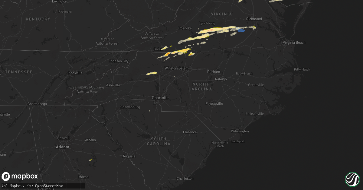
Hail Map in North Carolina on April 6, 2023
Get this storm
April 6 map
$229
one time, instant access
Download today. No call, no setup
Keep the $229
Bought the map and want the full workflow? Apply the entire $229 to a subscription within 7 days. None of it is wasted.
Every map, not just this one
This buys you this map. Subscription and you get every map we run, in the markets you choose from a few cities to whole states to nationwide. Plus real-time alerts the moment a storm fires.
Contact data
Name, contact info, occupancy, even credit band for addresses in the footprint. You go from where it hit to who to call.
Become the source they trust
Unlimited branding weather history reports on demand. You already have the documented answer ready for the property owner, and you are the one who showed up with it.
Property data and RoofTrace estimates
Pull up any address you have got, its value and the exact code rules for that jurisdiction, straight from One Click Code. Then RoofTrace estimates the squares, pitch, and roof value, priced the way you price.
Storm reports in North Carolina
North Carolina
| Date | Description |
|---|---|
| 04/06/20235:04 PM CDT | Thunderstorm winds blew down one tree near the intersection of victoria circle and kings court. |
| 04/06/20234:47 PM CDT | Trees were reported down on power lines near the intersection of old highway 52 and critcher drive. |
| 04/06/20234:19 PM CDT | Tree and power lines down off u.s. 52 near exit 134. |
| 04/06/20234:11 PM CDT | Report from mping: quarter |
| 04/06/20233:51 PM CDT | A local report indicates 1.00 inch wind near 3 N HIDDENITE |
| 04/06/20233:45 PM CDT | Report from mping: quarter |
| 04/06/20233:40 PM CDT | West side of town. |
| 04/06/20233:35 PM CDT | A local report indicates 1.00 inch wind near 1 SSW FLAT ROCK |
| 04/06/20233:21 PM CDT | Quarter-sized hail observed near dobson. This occurred with a separate thunderstorm from the one that produced hail in mt. Airy earlier around 400 pm edt. |
| 04/06/20233:10 PM CDT | Hail at least as large as quarters observed for several minutes in mt. Airy. |
| 04/06/20233:05 PM CDT | Quarter sized hail fell along the 300 block of south main street in mount airy. |
| 04/06/20233:05 PM CDT | A local report indicates 1.75 inch wind near 2 NW FLAT ROCK |
All States Impacted by Hail Map on April 6, 2023
Cities Impacted by Hail Map on April 6, 2023
- Woodville, MS
- Crosby, MS
- Gloster, MS
- Boerne, TX
- Mico, TX
- Pipe Creek, TX
- Fancy Gap, VA
- Galax, VA
- Woodlawn, VA
- Hillsville, VA
- Lynch Station, VA
- Centreville, MS
- Altavista, VA
- Evington, VA
- Meadows Of Dan, VA
- Laurel Fork, VA
- Gladys, VA
- Rustburg, VA
- Gretna, VA
- Mount Airy, NC
- Hurt, VA
- Concord, VA
- Liberty, MS
- Brookneal, VA
- Red House, VA
- Union Hall, VA
- Glade Hill, VA
- Rocky Mount, VA
- Penhook, VA
- Chatham, VA
- Sandy Level, VA
- Appomattox, VA
- Pamplin, VA
- Pittsville, VA
- Claudville, VA
- Lawsonville, NC
- Westfield, NC
- Stuart, VA
- Spout Spring, VA
- Eatonton, GA
- Prospect, VA
- Farmville, VA
- Long Island, VA
- Taylorsville, NC
- Hiddenite, NC
- Statesville, NC
- Spencer, VA
- Critz, VA
- Patrick Springs, VA
- Martinsville, VA
- Ridgeway, VA
- Rice, VA
- Burkeville, VA
- Jetersville, VA
- Charlotte Hall, MD
- Mechanicsville, MD
- La Plata, MD
- Hughesville, MD
- Huntingtown, MD
- Aquasco, MD
- Prince Frederick, MD
- Nathalie, VA
- Leonardtown, MD
- Amelia Court House, VA
- Crewe, VA
- Blackstone, VA
- California, MD
- Callaway, MD
- Great Mills, MD
- Lexington Park, MD
- Wilsons, VA
- Patuxent River, MD
- Solomons, MD
- Duson, LA
- Rayne, LA
- Ford, VA
- Dobson, NC
- Chester, SC
- McConnells, SC
- Wirtz, VA
- Grand Chenier, LA
- Danbury, NC
- Ferrum, VA
- King George, VA
- Mineral, VA
- Ararat, NC
- Pilot Mountain, NC
- Lexington, NC
- Bedford, VA
- Gueydan, LA
- Morse, LA
- Huddleston, VA
- Collinsville, VA
- Fieldale, VA
- Colonial Beach, VA
- Issue, MD
- Louisa, VA
- Spotsylvania, VA
- Bumpass, VA
- Montgomery, AL
- Bowling Green, VA
- Port Royal, VA
- Thurmond, NC
- Cullen, VA
- Axton, VA
- Dahlgren, VA
- Newburg, MD
- Partlow, VA
- Lenoir, NC
- Henry, VA
- Cameron, LA
- Easton, MD
- Grasonville, MD
- Queenstown, MD
- Centreville, MD
- Chester, VA
- Colonial Heights, VA
- Wingate, MD
- Toddville, MD
- Crapo, MD
- Nanticoke, MD
- Bivalve, MD
- Tyaskin, MD
- Quantico, MD
- Eden, MD
- Salisbury, MD
- Fruitland, MD
- Greensboro, MD
- Goldsboro, MD
- Harrington, DE
- Felton, DE
- Sandy Ridge, NC
- Stoneville, NC
- Eden, NC
- Montross, VA
- Princess Anne, MD
- Vienna, MD
- Woolford, MD
- Cambridge, MD
- Church Creek, MD
- Madison, MD
- Cascade, VA
- Ruffin, NC
- Port Republic, MD
- Java, VA
- Rappahannock Academy, VA
- Chesterfield, VA
- Church Road, VA
- Charlotte Court House, VA
- Hackberry, LA
- Hampden Sydney, VA
- Hague, VA
- Avenue, MD
- Clements, MD
- Hollywood, MD
- Fishing Creek, MD
- Abell, MD
- Bushwood, MD
- Chaptico, MD
- Cobb Island, MD
- Coltons Point, MD
- Green Bay, VA
- Victoria, VA
- Piney Point, MD
- Valley Lee, MD
- Warsaw, VA
- Kinsale, VA
- Saint Inigoes, MD
- Tall Timbers, MD
- Drayden, MD
- Scotland, MD
- Dameron, MD
- Ridge, MD
- Woodford, VA
- Benedict, MD
- Faulkner, MD
- Meherrin, VA
- Callands, VA
- Sunderland, MD
- North Beach, MD
- Claiborne, MD
- Sherwood, MD
- Chesapeake Beach, MD
- Saint Michaels, MD
- Chester, MD
- Owings, MD
- Mcdaniel, MD
- Crowley, LA
- Petersburg, VA
- Keysville, VA
- Whaleyville, MD
- Willards, MD
- Pittsville, MD
- Scott, LA
- Prince George, VA
- Phenix, VA
- Sutherlin, VA
- Moravian Falls, NC
- Traphill, NC


