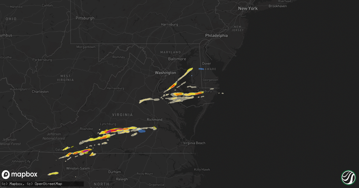
Hail Map on April 6, 2023
Get this storm
April 6 map
$229
one time, instant access
Download today. No call, no setup
Keep the $229
Bought the map and want the full workflow? Apply the entire $229 to a subscription within 7 days. None of it is wasted.
Every map, not just this one
This buys you this map. Subscription and you get every map we run, in the markets you choose from a few cities to whole states to nationwide. Plus real-time alerts the moment a storm fires.
Contact data
Name, contact info, occupancy, even credit band for addresses in the footprint. You go from where it hit to who to call.
Become the source they trust
Unlimited branding weather history reports on demand. You already have the documented answer ready for the property owner, and you are the one who showed up with it.
Property data and RoofTrace estimates
Pull up any address you have got, its value and the exact code rules for that jurisdiction, straight from One Click Code. Then RoofTrace estimates the squares, pitch, and roof value, priced the way you price.
States Impacted by Hail Map on April 6, 2023
Storm reports
Delaware
| Date | Description |
|---|---|
| 04/05/20237:43 PM CDT | Wires down at intersection of blue jay lane and canterbury road. |
Virginia
| Date | Description |
|---|---|
| 04/06/20236:10 PM CDT | Time estimated by radar. |
| 04/06/20236:05 PM CDT | Several trees down across southern chesterfield county. One tree damaged a home. |
| 04/06/20236:03 PM CDT | Thunderstorm winds blew down one tree along the 2000 block of wooding road. |
| 04/06/20236:00 PM CDT | A few power outages due to storm north of callao. Time estimated. |
| 04/06/20235:55 PM CDT | Trees down across southern chesterfield county. |
| 04/06/20235:25 PM CDT | M-ping report of trees and branches down around mcclean. |
| 04/06/20235:20 PM CDT | Tree downed on route 614. Time estimated from radar. |
| 04/06/20235:18 PM CDT | Over 100 power outages due to storm just to the north of amelia court house. Time estimated. |
| 04/06/20235:11 PM CDT | Trees snapped and uprooted at a residence. |
| 04/06/20235:06 PM CDT | Several trees down. Time estimated from radar data. |
| 04/06/20235:04 PM CDT | Multiple trees down near the intersection of route 360 and route 307 southwest of jetersville. Time estimated from radar data. |
| 04/06/20235:04 PM CDT | A local report indicates 1.00 inch wind near JETERSVILLE |
| 04/06/20234:54 PM CDT | A local report indicates 1.75 inch wind near 3 N RIDGEWAY |
| 04/06/20234:51 PM CDT | Thunderstorm winds blew down one tree along the intersection of greensboro road and lee ford camp road. |
| 04/06/20234:42 PM CDT | Over 700 power outages due to storm from hampden sydney to warsham. Time estimated. |
| 04/06/20234:33 PM CDT | Over 200 power outages likely due to storm near i-95 in northern caroline county. Time estimated. |
| 04/06/20234:30 PM CDT | Half dollar size hail at the lowes in farmville. Report relayed by nws rnk. |
| 04/06/20234:30 PM CDT | Several trees down and some wind damage at the prince edward county courthouse in farmville. Time estimated. |
| 04/06/20234:29 PM CDT | Report from mping: quarter |
| 04/06/20234:20 PM CDT | Report relayed from wsls-tv. |
| 04/06/20234:17 PM CDT | Multiple trees down near the 3000 block of partlow road |
| 04/06/20234:10 PM CDT | Corrects hail size from previous hail report in five forks. |
| 04/06/20234:10 PM CDT | Power outages likely due to storm on winston road in northern louisa county. Time estimated. |
| 04/06/20234:10 PM CDT | A local report indicates 1.00 inch wind near FIVE FORKS |
| 04/06/20234:10 PM CDT | Reported by trained spotter. |
| 04/06/20234:09 PM CDT | Hail slightly larger than golfball size. Windshields shattered in at least 2 vehicles and damage to roof. |
| 04/06/20234:09 PM CDT | Report from waller road. |
| 04/06/20234:08 PM CDT | Tree down just east of pamplin. |
| 04/06/20234:07 PM CDT | Thunderstorm winds blew down one tree that fell into a house along the 600 block of old well road. |
| 04/06/20233:59 PM CDT | Personal weather station kvaspots70 |
| 04/06/20233:50 PM CDT | A local report indicates 1.75 inch wind near PAMPLIN CITY |
| 04/06/20233:46 PM CDT | Tree down on thomas jefferson highway in the far northeastern corner of charlotte county. The tree down down in the 130 block of the highway. |
| 04/06/20233:44 PM CDT | A local report indicates 2.50 inch wind near 4 NE GLADYS |
| 04/06/20233:41 PM CDT | A local report indicates 2.00 inch wind near 3 NNE GLADYS |
| 04/06/20233:31 PM CDT | A local report indicates 1.75 inch wind near 2 ESE EVINGTON |
| 04/06/20233:28 PM CDT | Two trees were blown down between glade hill and union hall. |
| 04/06/20233:21 PM CDT | Thunderstorm winds blew down multiple tree branches and damaged the skirting of a home along the 600 block of marcus road. |
| 04/06/20233:18 PM CDT | Multiple trees blown down around rocky mount. |
| 04/06/20233:17 PM CDT | Reported by trained spotter. |
| 04/06/20233:09 PM CDT | Reported by trained spotter. |
| 04/06/20233:03 PM CDT | Three trees down in ferrum. |
| 04/06/20233:00 PM CDT | One tree was blown down in the community of henry. |
| 04/06/20232:45 PM CDT | A local report indicates 1.00 inch wind near 5 ESE EVINGTON |
| 04/06/20232:15 PM CDT | Hail reported at business on u.s. Highway 58. |
| 04/06/20232:10 PM CDT | A local report indicates 1.00 inch wind near 2 S GLADESBORO |
| 04/06/20231:54 PM CDT | Thunderstorm winds blew down one tree along the 8400 block of danville pike and close to the intersection of crooked oak road. |
| 04/06/20231:40 PM CDT | Quarter sized hail fell at mile marker 9.3 on interstate 77. |
Maryland
| Date | Description |
|---|---|
| 04/06/20236:50 PM CDT | Tree down. Time estimated from radar data. |
| 04/06/20236:10 PM CDT | Large hail in crapo... Md. |
| 04/06/20236:08 PM CDT | 15 powerline poles down along route 304... Between highway 301 and haymaker drive. |
| 04/06/20236:00 PM CDT | Mesonet station ew5728 grasonville. |
| 04/06/20235:45 PM CDT | A local report indicates 63 MPH wind near EASTON MUNICIPAL AIRPOR |
| 04/06/20235:40 PM CDT | Mping report of trees... Branches... And wires down near berwyn heights and college park. |
| 04/06/20235:29 PM CDT | A local report indicates 61 MPH wind near PATUXENT RIVER NAS |
| 04/06/20235:25 PM CDT | Mping report of trees and wires down near glen echo and cabin john. |
| 04/06/20235:11 PM CDT | A local report indicates 1.00 inch wind near 3 S HOLLYWOOD |
| 04/06/20235:05 PM CDT | Report of golf ball sized hail near leonardtown... Md. |
| 04/06/20235:05 PM CDT | A local report indicates 1.00 inch wind near LEONARDTOWN |
| 04/06/20234:58 PM CDT | A local report indicates 1.00 inch wind near 3 SW EAGLE HARBOR |
| 04/06/20234:54 PM CDT | Damage to siding and dented cars due to wind driven hail. |
| 04/06/20234:48 PM CDT | Multiple reports of golf ball sized hail between charlotte hall and hughesville |
| 04/06/20234:47 PM CDT | Multiple trees down near the intersection of roundhill rd. And charles st. Additinoally... Several older structures suffered some damage to exterior walls/roofs. |
| 04/06/20234:45 PM CDT | A local report indicates 1.25 inch wind near CHARLOTTE HALL |
| 04/06/20234:38 PM CDT | Numerous trees down along trinity church road |
| 04/06/20234:38 PM CDT | Numerous trees down along trinity church road |
North Carolina
| Date | Description |
|---|---|
| 04/06/20235:04 PM CDT | Thunderstorm winds blew down one tree near the intersection of victoria circle and kings court. |
| 04/06/20234:47 PM CDT | Trees were reported down on power lines near the intersection of old highway 52 and critcher drive. |
| 04/06/20234:19 PM CDT | Tree and power lines down off u.s. 52 near exit 134. |
| 04/06/20234:11 PM CDT | Report from mping: quarter |
| 04/06/20233:51 PM CDT | A local report indicates 1.00 inch wind near 3 N HIDDENITE |
| 04/06/20233:45 PM CDT | Report from mping: quarter |
| 04/06/20233:40 PM CDT | West side of town. |
| 04/06/20233:35 PM CDT | A local report indicates 1.00 inch wind near 1 SSW FLAT ROCK |
| 04/06/20233:21 PM CDT | Quarter-sized hail observed near dobson. This occurred with a separate thunderstorm from the one that produced hail in mt. Airy earlier around 400 pm edt. |
| 04/06/20233:10 PM CDT | Hail at least as large as quarters observed for several minutes in mt. Airy. |
| 04/06/20233:05 PM CDT | A local report indicates 1.75 inch wind near 2 NW FLAT ROCK |
| 04/06/20233:05 PM CDT | Quarter sized hail fell along the 300 block of south main street in mount airy. |
Alabama
| Date | Description |
|---|---|
| 04/06/20234:46 PM CDT | A local report indicates 1.00 inch wind near 1 SSW GUNTER AFB |
Mississippi
| Date | Description |
|---|---|
| 04/06/20233:01 PM CDT | Gloster police department reported quarter sized hail. |
| 04/06/202312:13 PM CDT | Corrects previous hail report from 5 wnw woodville. Wilkinson county emergency management reported quarter sized hail. |
| 04/06/202312:10 PM CDT | Wilkinson county emergency management reported quarter sized hail. |
Georgia
| Date | Description |
|---|---|
| 04/06/20233:30 PM CDT | Quarter-sized hail reported in eatonton. |
Cities Impacted by Hail Map on April 6, 2023
- Woodville, MS
- Crosby, MS
- Gloster, MS
- Boerne, TX
- Mico, TX
- Pipe Creek, TX
- Fancy Gap, VA
- Galax, VA
- Woodlawn, VA
- Hillsville, VA
- Lynch Station, VA
- Centreville, MS
- Altavista, VA
- Evington, VA
- Meadows Of Dan, VA
- Laurel Fork, VA
- Gladys, VA
- Rustburg, VA
- Gretna, VA
- Mount Airy, NC
- Hurt, VA
- Concord, VA
- Liberty, MS
- Brookneal, VA
- Red House, VA
- Union Hall, VA
- Glade Hill, VA
- Rocky Mount, VA
- Penhook, VA
- Chatham, VA
- Sandy Level, VA
- Appomattox, VA
- Pamplin, VA
- Pittsville, VA
- Claudville, VA
- Lawsonville, NC
- Westfield, NC
- Stuart, VA
- Spout Spring, VA
- Eatonton, GA
- Prospect, VA
- Farmville, VA
- Long Island, VA
- Taylorsville, NC
- Hiddenite, NC
- Statesville, NC
- Spencer, VA
- Critz, VA
- Patrick Springs, VA
- Martinsville, VA
- Ridgeway, VA
- Rice, VA
- Burkeville, VA
- Jetersville, VA
- Charlotte Hall, MD
- Mechanicsville, MD
- La Plata, MD
- Hughesville, MD
- Huntingtown, MD
- Aquasco, MD
- Prince Frederick, MD
- Nathalie, VA
- Leonardtown, MD
- Amelia Court House, VA
- Crewe, VA
- Blackstone, VA
- California, MD
- Callaway, MD
- Great Mills, MD
- Lexington Park, MD
- Wilsons, VA
- Patuxent River, MD
- Solomons, MD
- Duson, LA
- Rayne, LA
- Ford, VA
- Dobson, NC
- Chester, SC
- McConnells, SC
- Wirtz, VA
- Grand Chenier, LA
- Danbury, NC
- Ferrum, VA
- King George, VA
- Mineral, VA
- Ararat, NC
- Pilot Mountain, NC
- Lexington, NC
- Bedford, VA
- Gueydan, LA
- Morse, LA
- Huddleston, VA
- Collinsville, VA
- Fieldale, VA
- Colonial Beach, VA
- Issue, MD
- Louisa, VA
- Spotsylvania, VA
- Bumpass, VA
- Montgomery, AL
- Bowling Green, VA
- Port Royal, VA
- Thurmond, NC
- Cullen, VA
- Axton, VA
- Dahlgren, VA
- Newburg, MD
- Partlow, VA
- Lenoir, NC
- Henry, VA
- Cameron, LA
- Easton, MD
- Grasonville, MD
- Queenstown, MD
- Centreville, MD
- Chester, VA
- Colonial Heights, VA
- Wingate, MD
- Toddville, MD
- Crapo, MD
- Nanticoke, MD
- Bivalve, MD
- Tyaskin, MD
- Quantico, MD
- Eden, MD
- Salisbury, MD
- Fruitland, MD
- Greensboro, MD
- Goldsboro, MD
- Harrington, DE
- Felton, DE
- Sandy Ridge, NC
- Stoneville, NC
- Eden, NC
- Montross, VA
- Princess Anne, MD
- Vienna, MD
- Woolford, MD
- Cambridge, MD
- Church Creek, MD
- Madison, MD
- Cascade, VA
- Ruffin, NC
- Port Republic, MD
- Java, VA
- Rappahannock Academy, VA
- Chesterfield, VA
- Church Road, VA
- Charlotte Court House, VA
- Hackberry, LA
- Hampden Sydney, VA
- Hague, VA
- Avenue, MD
- Clements, MD
- Hollywood, MD
- Fishing Creek, MD
- Abell, MD
- Bushwood, MD
- Chaptico, MD
- Cobb Island, MD
- Coltons Point, MD
- Green Bay, VA
- Victoria, VA
- Piney Point, MD
- Valley Lee, MD
- Warsaw, VA
- Kinsale, VA
- Saint Inigoes, MD
- Tall Timbers, MD
- Drayden, MD
- Scotland, MD
- Dameron, MD
- Ridge, MD
- Woodford, VA
- Benedict, MD
- Faulkner, MD
- Meherrin, VA
- Callands, VA
- Sunderland, MD
- North Beach, MD
- Claiborne, MD
- Sherwood, MD
- Chesapeake Beach, MD
- Saint Michaels, MD
- Chester, MD
- Owings, MD
- Mcdaniel, MD
- Crowley, LA
- Petersburg, VA
- Keysville, VA
- Whaleyville, MD
- Willards, MD
- Pittsville, MD
- Scott, LA
- Prince George, VA
- Phenix, VA
- Sutherlin, VA
- Moravian Falls, NC
- Traphill, NC