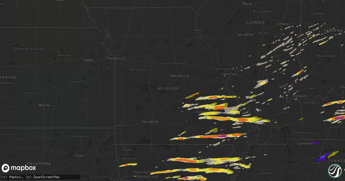
Hail Map in Missouri on April 3, 2018
Get this storm
April 3 map
$229
one time, instant access
Download today. No call, no setup
Keep the $229
Bought the map and want the full workflow? Apply the entire $229 to a subscription within 7 days. None of it is wasted.
Every map, not just this one
This buys you this map. Subscription and you get every map we run, in the markets you choose from a few cities to whole states to nationwide. Plus real-time alerts the moment a storm fires.
Contact data
Name, contact info, occupancy, even credit band for addresses in the footprint. You go from where it hit to who to call.
Become the source they trust
Unlimited branding weather history reports on demand. You already have the documented answer ready for the property owner, and you are the one who showed up with it.
Property data and RoofTrace estimates
Pull up any address you have got, its value and the exact code rules for that jurisdiction, straight from One Click Code. Then RoofTrace estimates the squares, pitch, and roof value, priced the way you price.
Storm reports in Missouri
Missouri
| Date | Description |
|---|---|
| 04/03/20186:30 PM CDT | Three farm sheds damaged on dunklin county road 657 just west of town. Possible tornado. |
| 04/03/20186:24 PM CDT | Two structures down as well as power poles along state highway ff near cr820 |
| 04/03/20186:14 PM CDT | Ef-1 tornado with a peak wind of 110 mph was on the ground for 2.5 miles with a maximum width of 125 yards. The tornado touched down at approx. 614 pm cdt... 3 miles nw |
| 04/03/20186:10 PM CDT | Utility pole snapped along highway k near hornersville. Possible tornado. |
| 04/03/20186:05 PM CDT | Video of a tornado near the missouri-arkansas state line between arbyrd and leachville. Tornado may have begun in arkansas. |
| 04/03/20185:58 PM CDT | Ef-0 tornado touched down approximately 4 miles southeast of penermon and lifted 0.5 miles southeast of baker. Path length was 4.5 miles with peak winds of 85mph. Sever |
| 04/03/20185:50 PM CDT | Golf ball size hail reported. |
| 04/03/20185:48 PM CDT | A local report indicates 1.00 inch wind near 3 NE DEXTER |
| 04/03/20185:40 PM CDT | Half dollar size hail report |
| 04/03/20185:34 PM CDT | Quarter size hail reported. |
| 04/03/20185:29 PM CDT | Reported at the cape girardeau regional airport which sets in scott county missouri. One quarter mile visibility reported with this storm. |
| 04/03/20185:25 PM CDT | A local report indicates 1.00 inch wind near 1 E SCOTT CITY |
| 04/03/20185:10 PM CDT | Golfball size hail reported in the communtiy of allenville. |
| 04/03/20185:07 PM CDT | Power outages reported throughout the county. |
| 04/03/20185:06 PM CDT | Straight line wind damage with peak winds of 75 mph and a path length of approximately 2/3 mile. Several homes had shingle or roof damage. One home had soffit damage al |
| 04/03/20184:55 PM CDT | Ping pong hail reported in the community |
| 04/03/20184:53 PM CDT | A local report indicates 2.00 inch wind near 4 W POPLAR BLUFF |
| 04/03/20184:30 PM CDT | Reported west of ellsinore. |
| 04/03/20184:25 PM CDT | Late report. Quarter size hail reported in the community. |
| 04/03/20184:20 PM CDT | Power outages reported throughout the county. |
| 04/03/20184:00 PM CDT | A local report indicates 1.00 inch wind near IRONTON |
| 04/03/20184:00 PM CDT | Quarter-size hail at heifer mel's diner. |
| 04/03/20183:50 PM CDT | A local report indicates 1.00 inch wind near 2 WSW GREER |
| 04/03/20183:49 PM CDT | Social media picture of golf ball size hail north of alton and west-southwest of greer. |
| 04/03/20183:21 PM CDT | Delayed report with photo on social media. Time estimated from radar. |
| 04/03/20183:14 PM CDT | Delayed report on twitter. Central iron county south of council bluff lake. Location approximate. Time estimated from radar. |
| 04/03/20183:11 PM CDT | A local report indicates 1.00 inch wind near 4 SW WEST PLAINS |
| 04/03/20183:10 PM CDT | A local report indicates 1.00 inch wind near POMONA |
| 04/03/20183:07 PM CDT | Corrects previous hail report from bonne terre. Hail larger than quarters. Photo posted to social media. Time estimated from radar. |
| 04/03/20183:02 PM CDT | A local report indicates 1.75 inch wind near POTTERSVILLE |
| 04/03/20182:54 PM CDT | Quarter-size hail in bixby. |
| 04/03/20182:53 PM CDT | Cloud 9 ranch. |
| 04/03/20182:49 PM CDT | A local report indicates 1.00 inch wind near 1 SE POTOSI |
| 04/03/20182:48 PM CDT | 0.75 miles north of potosi on highway 21. |
| 04/03/20182:47 PM CDT | Delayed report from social media. Time estimated from radar. |
| 04/03/20182:37 PM CDT | Delayed report-quarter size hail report via social media video. Time estimated via radar. |
| 04/03/201812:10 AM CDT | At 509 PM CDT, a severe thunderstorm was located over Hoxie, moving east at 65 mph. HAZARD...60 mph wind gusts and quarter size hail. SOURCE...Public. IMPACT...Hail damage to vehicles is expected. Expect wind damage to roofs, siding, and trees. Locations impacted include... Jonesboro, Paragould, Walnut Ridge, Hoxie, Bono, Brookland, Monette, Black Rock, Crowleys Ridge State Park, Lake Frierson State Park, Oak Grove Heights, College City, Portia, Alicia, Minturn, Walcott, Fontaine, Sedgwick, Powhatan and Strangers Home. |
| 04/02/201810:58 PM CDT | At 358 PM CDT, a severe thunderstorm was located 8 miles southwest of Handy, or 22 miles southwest of Van Buren, moving east at 70 mph. HAZARD...60 mph wind gusts and half dollar size hail. SOURCE...Radar indicated. IMPACT...Hail damage to vehicles is expected. Expect wind damage to roofs, siding, and trees. Locations impacted include... Doniphan, Budapest, Oxly, Fairdealing, Handy, Grandin and Briar. |
| 04/02/201810:58 PM CDT | At 358 PM CDT, severe thunderstorms were located along a line extending from near Knob Lick to 6 miles north of Saco, moving east at 50 mph. HAZARD...60 mph wind gusts and quarter size hail. SOURCE...Radar indicated. IMPACT...Hail damage to vehicles is expected. Expect wind damage to roofs, siding, and trees. Locations impacted include... Fredericktown, Junction City, Cobalt, Womac, Knob Lick, Mine La Motte, Libertyville and Catherine Place. |
| 04/02/201810:55 PM CDT | At 355 PM CDT, severe thunderstorms were located along a line extending from near Junction City to 8 miles southwest of Annapolis, moving east at 45 mph. HAZARD...60 mph wind gusts and quarter size hail. SOURCE...Radar indicated. IMPACT...Hail damage to vehicles is expected. Expect wind damage to roofs, siding, and trees. Locations impacted include... Marble Hill, Sam A. Baker State Park, Patton, Alliance, Lodi, Cascade, Leopold, Grassy, Sedgewickville and Glenallen. |
| 04/02/201810:46 PM CDT | At 346 PM CDT, a severe thunderstorm was located near Annapolis, moving east at 45 mph. HAZARD...Golf ball size hail and 60 mph wind gusts. SOURCE...Radar indicated. IMPACT...People and animals outdoors will be injured. Expect hail damage to roofs, siding, windows, and vehicles. Expect wind damage to roofs, siding, and trees. Locations impacted include... Annapolis, Marquand, Buckhorn, Saco, Des Arc, Sabula and Vulcan. |
| 04/02/201810:41 PM CDT | At 341 PM CDT, a severe thunderstorm was located 8 miles west of Alton, or 13 miles north of Thayer, moving east at 50 mph. HAZARD...60 mph wind gusts and quarter size hail. SOURCE...Radar indicated. IMPACT...Hail damage to vehicles is expected. Expect wind damage to roofs, siding, and trees. Locations impacted include... Alton... Thomasville... Greer... Wilderness... |
| 04/02/201810:14 PM CDT | At 314 PM CDT, a severe thunderstorm was located near Belleview, moving east at 45 mph. HAZARD...60 mph wind gusts and quarter size hail. SOURCE...Radar indicated. IMPACT...Hail damage to vehicles is expected. Expect wind damage to roofs, siding, and trees. Locations impacted include... Farmington, Fredericktown, Ironton, Pilot Knob, Iron Mountain Lake, Arcadia, Junction City, Belleview, Knob Lick, Iron Mountain, Roselle, Catherine Place, Granite, Mine La Motte, Libertyville and Doe Run.This also includes Johnsons Shut-Ins State Park, Fort DavidsonHistoric Site, and Elephant Rocks State Park. |
| 04/02/201810:13 PM CDT | At 312 PM CDT, a severe thunderstorm was located over Reynolds, moving east at 45 mph. HAZARD...60 mph wind gusts and quarter size hail. SOURCE...Radar indicated. IMPACT...Hail damage to vehicles is expected. Expect wind damage to roofs, siding, and trees. Locations impacted include... Reynolds, Bunker, Annapolis, Glover, Centerville, Sabula, Chloride, Corridon, Redford, Hogan, Lesterville and Black.This also includes Johnsons Shut-Ins State Park and Taum SaukMountain State Park. |
| 04/02/201810:11 PM CDT | At 311 PM CDT, a severe thunderstorm was located 8 miles southeast of Willow Springs, moving northeast at 50 mph. HAZARD...Quarter size hail. SOURCE...Radar indicated. IMPACT...Damage to vehicles is expected. Locations impacted include... Mountain View... Willow Springs... Pomona... Peace Valley... |
| 04/02/201810:09 PM CDT | At 309 PM CDT, a severe thunderstorm was located 10 miles north of Eminence, or 25 miles northwest of Van Buren, moving east at 50 mph. HAZARD...Quarter size hail. SOURCE...Radar indicated. IMPACT...Damage to vehicles is expected. Locations impacted include... Midridge... |
| 04/02/20189:59 PM CDT | At 259 PM CDT, a severe thunderstorm was located 11 miles north of Bakersfield, or 12 miles west of West Plains, moving east at 50 mph. HAZARD...60 mph wind gusts and quarter size hail. SOURCE...Radar indicated. IMPACT...Hail damage to vehicles is expected. Expect wind damage to roofs, siding, and trees. Locations impacted include... West Plains... South Fork... Brandsville... Pottersville... Caulfield... |
| 04/02/20189:51 PM CDT | At 251 PM CDT, a severe thunderstorm was located over Mineral Point, moving east at 45 mph. HAZARD...60 mph wind gusts and half dollar size hail. SOURCE...Trained weather spotters reported quarter size hail in Potosi. IMPACT...Hail damage to vehicles is expected. Expect wind damage to roofs, siding, and trees. Locations impacted include... Bonne Terre, Desloge, Potosi, Bloomsdale, Mineral Point, Rocky Ridge, Cadet, Valles Mill and French Village.This includes Interstate 55 in Missouri between exits 154 and 162. This also includes St. Francois State Park. |
| 04/02/20189:37 PM CDT | At 236 PM CDT, a severe thunderstorm was located 9 miles southwest of Viburnum, moving east at 50 mph. HAZARD...60 mph wind gusts and quarter size hail. SOURCE...Radar indicated. IMPACT...Hail damage to vehicles is expected. Expect wind damage to roofs, siding, and trees. Locations impacted include... Viburnum, Irondale, Courtois, Belleview, Bixby, Caledonia, Belgrade, Dillard and Granite.This also includes Elephant Rocks State Park and Dillard MillHistoric Site. |
| 04/02/20189:35 PM CDT | At 234 PM CDT, a severe thunderstorm was located 10 miles southwest of Viburnum, or 12 miles east of Salem, moving east at 50 mph. HAZARD...Quarter size hail. SOURCE...Radar indicated. IMPACT...Damage to vehicles is expected. Locations impacted include... Stone Hill... Howes Mill... Boss... |
| 04/02/20189:20 PM CDT | At 220 PM CDT, a severe thunderstorm was located 8 miles northeast of Cherryville, moving east at 40 mph. HAZARD...60 mph wind gusts and quarter size hail. SOURCE...Radar indicated. IMPACT...Hail damage to vehicles is expected. Expect wind damage to roofs, siding, and trees. Locations impacted include... Potosi, Mineral Point, Old Mines, Latty and Shirley. |
All States Impacted by Hail Map on April 3, 2018
Cities Impacted by Hail Map on April 3, 2018
- Palestine, TX
- Valley Mills, TX
- Gatesville, TX
- Loretto, KY
- Lebanon, KY
- Saint Francis, KY
- Raywick, KY
- Chaffee, MO
- Cape Girardeau, MO
- McClure, IL
- Scott City, MO
- Somerset, OH
- Blue Rock, OH
- New Lexington, OH
- Roseville, OH
- Mcconnelsville, OH
- Crooksville, OH
- Chandlersville, OH
- Philo, OH
- Frankfort, KY
- Sawyer, OK
- Tyler, TX
- Orient, OH
- Grove City, OH
- Florence, KY
- Burlington, KY
- Union, KY
- Latonia, KY
- Ft Mitchell, KY
- Erlanger, KY
- Lesterville, MO
- Centerville, MO
- Bunker, MO
- San Antonio, TX
- Converse, TX
- Tolono, IL
- Brookland, AR
- Waskom, TX
- Bryan, TX
- New Llano, LA
- Leesville, LA
- Campbellsville, KY
- Birch Tree, MO
- Camden, OH
- Jerusalem, AR
- Shirley, AR
- Clinton, AR
- Kevil, KY
- Kempner, TX
- Killeen, TX
- Paragould, AR
- Cardwell, MO
- Melbourne, AR
- Calico Rock, AR
- Vincennes, IN
- Lawrenceville, IL
- Doniphan, MO
- Alton, MO
- Fremont, MO
- Dexter, MO
- Broseley, MO
- Poplar Bluff, MO
- Fisk, MO
- Grandin, MO
- Bernie, MO
- Fairdealing, MO
- Dudley, MO
- Harviell, MO
- Westport, KY
- Marysville, IN
- New Washington, IN
- Charlestown, IN
- Beulah, MO
- Edgar Springs, MO
- Newburg, MO
- Salem, MO
- Lenox, MO
- Duke, MO
- Rolla, MO
- Franklin, TX
- Calvert, TX
- Augusta, AR
- Bradford, AR
- Newport, AR
- Newman, IL
- Hindsboro, IL
- Oakland, IL
- Brocton, IL
- Potosi, MO
- Steelville, MO
- Cash, AR
- Weiner, AR
- Mayslick, KY
- Vanceburg, KY
- Manchester, OH
- Cynthiana, KY
- Aberdeen, OH
- Mount Olivet, KY
- Corinth, KY
- Falmouth, KY
- Berry, KY
- Williamstown, KY
- Brooksville, KY
- Germantown, KY
- Dover, KY
- Maysville, KY
- Augusta, KY
- Leachville, AR
- Steele, MO
- Hornersville, MO
- Blytheville, AR
- Middle Brook, MO
- Doe Run, MO
- Belleview, MO
- Farmington, MO
- Ironton, MO
- Pilot Knob, MO
- Sullivan, IL
- Call, TX
- Joshua, TX
- Cleburne, TX
- Alvarado, TX
- Temple, TX
- Scott, AR
- Little Rock, AR
- North Little Rock, AR
- Ashville, OH
- Lometa, TX
- Cherokee, TX
- Lampasas, TX
- San Saba, TX
- Saint Francisville, IL
- Marquand, MO
- Fredericktown, MO
- Marble Hill, MO
- Patton, MO
- North Liberty, IN
- Walkerton, IN
- Lakeville, IN
- Mount Sterling, OH
- Bloomingburg, OH
- Heber Springs, AR
- Wilburn, AR
- Judsonia, AR
- Pangburn, AR
- Bald Knob, AR
- Middlebury, IN
- Bristol, IN
- Goshen, IN
- Germantown, OH
- Franklin, OH
- Middletown, OH
- Dayton, OH
- Miamisburg, OH
- Sumner, IL
- West Plains, MO
- Pottersville, MO
- Plainfield, IN
- Canmer, KY
- Sweeden, KY
- Mount Sherman, KY
- Bonnieville, KY
- Caneyville, KY
- Summersville, KY
- Roundhill, KY
- Brownsville, KY
- Magnolia, KY
- Cub Run, KY
- Jetson, KY
- Mammoth Cave, KY
- Greensburg, KY
- Munfordville, KY
- Buffalo, KY
- Clarkson, KY
- Bee Spring, KY
- Leitchfield, KY
- Crossville, IL
- Carmi, IL
- Mena, AR
- Boles, AR
- Shreveport, LA
- Chilton, TX
- Caulfield, MO
- Zanoni, MO
- Tecumseh, MO
- Dora, MO
- Carthage, TX
- Plymouth, IN
- West Portsmouth, OH
- Clinton, IN
- Terre Haute, IN
- Bloomfield, MO
- Advance, MO
- Puxico, MO
- Bell City, MO
- Batchelor, LA
- Lettsworth, LA
- De Valls Bluff, AR
- Jonesboro, AR
- Ripley, TN
- Luxora, AR
- Vinton, OH
- Bidwell, OH
- Cheshire, OH
- Gallipolis, OH
- San Ygnacio, TX
- Provencal, LA
- Finley, TN
- Lenox, TN
- Dyersburg, TN
- Jonesboro, TX
- Black, MO
- Bronson, MI
- Saint Louis, MO
- Cave City, KY
- Horse Cave, KY
- Jacksonville, TX
- Bonne Terre, MO
- New Hope, KY
- New Haven, KY
- London, OH
- South Solon, OH
- Jeffersonville, OH
- Dry Ridge, KY
- Ripley, OH
- Russellville, OH
- Foster, KY
- West Union, OH
- Owenton, KY
- Butler, KY
- Sadieville, KY
- New Liberty, KY
- Drew, MS
- Bixby, MO
- Houston, TX
- Hodgenville, KY
- Springfield, KY
- Whitehouse, TX
- Alicia, AR
- Hoxie, AR
- Eaton, OH
- Eldorado, OH
- West Manchester, OH
- Liberty, IN
- Richmond, IN
- Lewisburg, OH
- Jackson, MO
- Senatobia, MS
- Hustonville, KY
- Middleburg, KY
- Farina, IL
- Robinson, IL
- Hazen, AR
- Sandgap, KY
- McKee, KY
- Alexandria, KY
- Morning View, KY
- Independence, KY
- Mount Pleasant, AR
- Radcliff, KY
- La Grange, KY
- Tunica, MS
- Dundee, MS
- Burkeville, TX
- North Salem, IN
- Roachdale, IN
- French Village, MO
- Wesco, MO
- Cook Sta, MO
- Bloomsdale, MO
- Valles Mines, MO
- Cadet, MO
- Mineral Point, MO
- Cherryville, MO
- Sainte Genevieve, MO
- Harrisburg, AR
- Bay, AR
- Lake City, AR
- Trumann, AR
- Lepanto, AR
- Marked Tree, AR
- Smithville, AR
- Fort Thomas, KY
- Covington, KY
- Newport, KY
- Sellersburg, IN
- Jeffersonville, IN
- Clarksville, IN
- Liberty, KY
- Vandervoort, AR
- Cove, AR
- Wickes, AR
- Flatonia, TX
- Smithville, TX
- Waltonville, IL
- Ashley, IL
- Woodlawn, IL
- Texico, IL
- Mount Vernon, IL
- Dix, IL
- Fifty Six, AR
- Harriet, AR
- Batesville, AR
- Guion, AR
- Mountain View, AR
- Sidney, AR
- Sage, AR
- Evening Shade, AR
- Cave City, AR
- Horseshoe Bend, AR
- Big Flat, AR
- Poughkeepsie, AR
- South Webster, OH
- Wheelersburg, OH
- Mannsville, KY
- Bradfordsville, KY
- Morgantown, KY
- Smiths Grove, KY
- Elk Horn, KY
- Gravel Switch, KY
- Bowling Green, KY
- Rogers, TX
- Buckholts, TX
- Oglesby, TX
- Willow Springs, MO
- Petersburg, IN
- Washington, IN
- Patoka, IN
- Hazleton, IN
- Monroe City, IN
- Damascus, AR
- Oak Hill, OH
- Rio Grande, OH
- Letart, WV
- Middleport, OH
- West Columbia, WV
- Thurman, OH
- Florien, LA
- California, KY
- Evans, LA
- Newton, TX
- Wiergate, TX
- Deridder, LA
- Georgetown, OH
- Hamersville, OH
- Thebes, IL
- Leopold, MO
- Whitewater, MO
- Brodhead, KY
- Stanford, KY
- Mount Vernon, KY
- Berea, KY
- Waynesburg, KY
- Crab Orchard, KY
- Orlando, KY
- Vincent, KY
- Kings Mountain, KY
- Hamburg, AR
- Floral, AR
- Drasco, AR
- Caraway, AR
- Concord, AR
- Rosie, AR
- Magness, AR
- Osceola, AR
- Locust Grove, AR
- Newark, AR
- Sulphur Rock, AR
- Desha, AR
- Dyess, AR
- Tuckerman, AR
- Bruceville, IN
- Edwardsville, IL
- Ellsinore, MO
- Greenfield, TN
- Strawberry, AR
- Westfield, IL
- Casey, IL
- Metropolis, IL
- Brookshire, TX
- Allendale, IL
- Mount Carmel, IL
- Moody, TX
- Ingraham, IL
- Noble, IL
- Clay City, IL
- Ladoga, IN
- Upton, KY
- Big Clifty, KY
- Sonora, KY
- Wilson, AR
- Swifton, AR
- Amagon, AR
- Pleasant Plains, AR
- Burnt Prairie, IL
- Golden Gate, IL
- Marks, MS
- Lambert, MS
- Simmesport, LA
- Jackson, OH
- Lucasville, OH
- Minford, OH
- Portsmouth, OH
- Bicknell, IN
- Oaktown, IN
- Edwardsport, IN
- Norris City, IL
- Milford, TX
- Rusk, TX
- Fort Polk, LA
- Pitkin, LA
- New Haven, WV
- Mason, WV
- Thornton, TX
- Marlin, TX
- Groesbeck, TX
- Kosse, TX
- Riesel, TX
- Bremen, IN
- Dover, AR
- Pelsor, AR
- Dennard, AR
- Cincinnati, OH
- Hillsboro, TX
- Caddo Gap, AR
- La Vernia, TX
- Adkins, TX
- Stockdale, TX
- Seguin, TX
- Nixon, TX
- Sparta, TN
- Walling, TN
- Rock Island, TN
- Doyle, TN
- Quebeck, TN
- Portland, OH
- Ravenswood, WV
- Evansville, IN
- Bauxite, AR
- Naylor, MO
- Jbsa Ft Sam Houston, TX
- Saint Hedwig, TX
- West Union, WV
- New Milton, WV
- College Corner, OH
- West College Corner, IN
- Oxford, OH
- Bath, IN
- Charleston, IL
- Ashmore, IL
- Stewardson, IL
- Mattoon, IL
- Neoga, IL
- Gays, IL
- Trilla, IL
- Windsor, IL
- Kansas, IL
- Lerna, IL
- Paris, IL
- Arlington, TX
- Grand Prairie, TX
- Bon Wier, TX
- Grand Chain, IL
- Villa Ridge, IL
- Olmsted, IL
- Alexander, AR
- Mabelvale, AR
- Dana, IN
- Chrisman, IL
- West Harrison, IN
- Bedias, TX
- Iola, TX
- De Witt, AR
- Scurry, TX
- Ennis, TX
- West Alexandria, OH
- Harrisburg, OH
- Williamsport, OH
- Lockbourne, OH
- Commercial Point, OH
- Beckville, TX
- Marshall, TX
- Bismarck, MO
- Boss, MO
- Arcadia, MO
- Hardinsburg, KY
- Cloverport, KY
- Cecilia, KY
- Irvington, KY
- Garfield, KY
- Vine Grove, KY
- Elizabethtown, KY
- Falls Of Rough, KY
- West Point, KY
- Rineyville, KY
- Westview, KY
- Custer, KY
- Fordsville, KY
- Harned, KY
- De Soto, MO
- Laurel, IN
- Metamora, IN
- New Lebanon, OH
- Farmersville, OH
- Somerville, OH
- Brookville, IN
- Sedgewickville, MO
- London, KY
- Annville, KY
- Bono, AR
- Arbyrd, MO
- Canal Winchester, OH
- Lancaster, OH
- Amanda, OH
- Baltimore, OH
- Lithopolis, OH
- Columbus, OH
- Carroll, OH
- Groveport, OH
- Oran, MO
- Zalma, MO
- Sturdivant, MO
- Cameron, WV
- Wind Ridge, PA
- Holbrook, PA
- Aleppo, PA
- Clayton, IN
- Rison, AR
- Circleville, OH
- Rockville, IN
- Carbon, IN
- Searcy, AR
- Rose Bud, AR
- Quitman, AR
- Pearcy, AR
- Bonnerdale, AR
- Hot Springs National Park, AR
- Mart, TX
- Essex, MO
- Mill Shoals, IL
- Waldron, AR
- Batesville, IN
- Sunman, IN
- Sutherland Springs, TX
- Fox, AR
- Edgemont, AR
- Hector, AR
- Wallis, TX
- Sealy, TX
- Yorktown, IN
- Makanda, IL
- Cobden, IL
- Anna, IL
- Mcminnville, TN
- Hillsboro, IN
- Waynetown, IN
- Veedersburg, IN
- Kingman, IN
- Saint James, MO
- Davisville, MO
- Belgrade, MO
- Manila, AR
- Halls, TN
- Dell, AR
- Gates, TN
- Paris, TX
- Flora, IL
- Stamping Ground, KY
- Pleasureville, KY
- Lockport, KY
- Marianna, AR
- Poplar Grove, AR
- Lexa, AR
- Cat Spring, TX
- Alleyton, TX
- Huntsville, TX
- Madisonville, TX
- Van Buren, MO
- Redford, MO
- Ellington, MO
- Lodi, MO
- Patterson, MO
- Vulcan, MO
- Greenville, MO
- Silva, MO
- Des Arc, MO
- Clubb, MO
- Piedmont, MO
- Eddy, TX
- Bruceville, TX
- Lorena, TX
- Annapolis, MO
- Carlisle, AR
- Pasadena, TX
- Indianapolis, IN
- Mccordsville, IN
- Heavener, OK
- Concepcion, TX
- South Shore, KY
- Haworth, OK
- Tamms, IL
- Brookville, OH
- Rosebud, TX
- Spring Valley, OH
- Bellbrook, OH
- Xenia, OH
- Waterloo, IL
- Blossom, TX
- Crawfordsville, IN
- Bokchito, OK
- Bennington, OK
- Madison, IN
- Vevay, IN
- Bedford, KY
- Milton, KY
- Sikeston, MO
- Matthews, MO
- Albion, IL
- Coldwater, MS
- Hernando, MS
- Bremond, TX
- Verona, KY
- Crittenden, KY
- Winchester, OH
- Florence, IN
- Warsaw, KY
- Walton, KY
- Bethel, OH
- New Richmond, OH
- Patriot, IN
- Sardinia, OH
- De Mossville, KY
- Moscow, OH
- Gainesville, MO
- Kinmundy, IL
- Saint Peter, IL
- Edgewood, IL
- Dale, IN
- Neelyville, MO
- Stonewall, LA
- Smithville, TN
- Broken Bow, OK
- Itasca, TX
- Rosedale, IN
- Sturgis, KY
- Buncombe, IL
- Como, MS
- Bunkie, LA
- Cottonport, LA
- Oblong, IL
- Martinsville, IL
- Annapolis, IL
- West York, IL
- Highland, IL
- Pocahontas, IL
- Murphysboro, IL
- De Soto, IL
- Elkville, IL
- West Fork, AR
- Prairie Grove, AR
- Winslow, AR
- North Bend, OH
- Hebron, KY
- Cleves, OH
- Detroit, TX
- Powderly, TX
- Oldenburg, IN
- Honobia, OK
- Smithville, OK
- Brookeland, TX
- Jasper, TX
- Keithville, LA
- Newton, IL
- Ramsey, IL
- Brownstown, IL
- Beecher City, IL
- Cowden, IL
- Westville, IL
- Versailles, IN
- Dillsboro, IN
- Merryville, LA
- Midway, TX
- Monrovia, IN
- Stilesville, IN
- Cloverdale, IN
- Martinsville, IN
- Glenallen, MO
- Friedheim, MO
- Daisy, MO
- Pomona, MO
- Keene, TX
- Saint Jacob, IL
- Marine, IL
- Princeton, LA
- Haughton, LA
- Idaville, IN
- Shelbyville, IL
- Assumption, IL
- Timpson, TX
- Athens, LA
- Fort Knox, KY
- Maynard, AR
- Success, AR
- Reklaw, TX
- Laneville, TX
- Seabrook, TX
- Webster, TX
- Bellaire, TX
- La Porte, TX
- Pearland, TX
- South Houston, TX
- Sanders, KY
- Sparta, KY
- Amelia, OH
- Ghent, KY
- Felicity, OH
- Keatchie, LA
- Thompsonville, IL
- Knox, IN
- Grovertown, IN
- Marshall, IL
- Dennison, IL
- West Terre Haute, IN
- Brickeys, AR
- Robinsonville, MS
- Sextons Creek, KY
- Manchester, KY
- Spencer, TN
- Hillsdale, IN
- Success, MO
- Rosston, AR
- Reelsville, IN
- Danville, IN
- Fillmore, IN
- Greencastle, IN
- Coatesville, IN
- Brazil, IN
- Amo, IN
- Ragsdale, IN
- Glendale, KY
- Holly Springs, MS
- Muse, OK
- Whitesboro, OK
- Hodgen, OK
- Ivanhoe, TX
- New Castle, KY
- Eminence, KY
- Bethlehem, KY
- Holland, TX
- Moody, MO
- Greenville, IL
- Qulin, MO
- Mount Judea, AR
- Alhambra, IL
- Alma, IL
- Morganfield, KY
- Poteau, OK
- Witts Springs, AR
- Hagarville, AR
- Irving, TX
- Hanna, IN
- Wanatah, IN
- Union Mills, IN
- Lonoke, AR
- Ravenden Springs, AR
- Nacogdoches, TX
- Mount Enterprise, TX
- Cushing, TX
- Bloomingdale, IN
- Montezuma, IN
- Walnut Ridge, AR
- Monette, AR
- Lynn, AR
- Cooter, MO
- Powhatan, AR
- Marshall, AR
- Farmersburg, IN
- Piqua, OH
- Copperas Cove, TX
- Sidell, IL
- Metcalf, IL
- Hume, IL
- West Union, IL
- New Harmony, IN
- Poseyville, IN
- Griffin, IN
- Altamont, IL
- Watson, IL
- Teague, TX
- Dallas, TX
- Bossier City, LA
- Sims, IL
- Keenes, IL
- Johnsonville, IL
- Saint Francisville, LA
- Darlington, IN
- Olney, IL
- Greenwood, LA
- Troy, OH
- Englewood, OH
- West Milton, OH
- Tipp City, OH
- Briggs, TX
- Anna, OH
- Arthur, IL
- Decker, IN
- Byhalia, MS
- Nashoba, OK
- Bonita, LA
- Jones, LA
- Evergreen, LA
- Carterville, IL
- Cambria, IL
- Carbondale, IL
- Canehill, AR
- Saint Joe, AR
- Tichnor, AR
- Greenfield, IN
- Park Hills, MO
- Stuttgart, AR
- Bryant, AR
- Fairborn, OH
- Willow Hill, IL
- Pinckneyville, IL
- Pittsboro, IN
- Toledo, IL
- Greenup, IL
- West Liberty, IL
- Dundas, IL
- Malvern, AR
- Sabina, OH
- Leesburg, OH
- Cross Plains, IN
- Sesser, IL
- Benton, IL
- Mulkeytown, IL
- Whittington, IL
- Du Quoin, IL
- Brookport, IL
- McGregor, TX
- Frierson, LA
- Muncie, IN
- Vergennes, IL
- Ava, IL
- Campbell Hill, IL
- Percy, IL
- Sumner, MS
- Tutwiler, MS
- Morocco, IN
- Granite City, IL
- Hartford, IL
- East Alton, IL
- Clayton, OH
- Ullin, IL
- Fort Hood, TX
- Anacoco, LA
- Zionsville, IN
- Whitestown, IN
- Catron, MO
- Altenburg, MO
- Old Appleton, MO
- Uniontown, MO
- Frohna, MO
- Oak Ridge, MO
- Rosanky, TX
- Millersville, MO
- Perryville, MO
- Caledonia, MO
- Licking, MO
- East Bernstadt, KY
- Smithfield, KY
- Cedar Grove, IN
- Oakwood, TX
- Fairfield, TX
- Farrar, MO
- Golconda, IL
- Warm Springs, AR
- Carrollton, TX
- Kemp, TX
- Burleson, TX
- Westfield, IN
- Mode, IL
- White Mills, KY
- Humboldt, IL
- Arcola, IL
- Tow, TX
- Bluffton, TX
- Llano, TX
- Elkins, AR
- Combs, AR
- Grayville, IL
- Dubach, LA
- Milford, OH
- Batavia, OH
- England, AR
- Rossburg, OH
- Ansonia, OH
- Waveland, IN
- Arthur City, TX
- Bagwell, TX
- Evansville, AR
- Fayetteville, AR
- Monterey, IN
- Culver, IN
- Turners Station, KY
- Worthville, KY
- Campbellsburg, KY
- New Vienna, OH
- Beaver, OH
- McDermott, OH
- Point Pleasant, WV
- Owensville, IN
- Thorntown, IN
- Barlow, KY
- La Center, KY
- Mounds, IL
- Pulaski, IL
- Olive Branch, IL
- Karnak, IL
- Karnack, TX
- Effingham, IL
- Williamsville, MO
- El Dorado, AR
- Bee Branch, AR
- Clarendon, AR
- Brinkley, AR
- Lufkin, TX
- Benavides, TX
- London, AR
- De Berry, TX
- Williford, AR
- Hardy, AR
- Rosine, KY
- Horse Branch, KY
- Olaton, KY
- Gillett, AR
- Marshall, IN
- Jacob, IL
- Marion, IL
- Pollok, TX
- Plato, MO
- Belton, TX
- Normangee, TX
- Corydon, KY
- Cave In Rock, IL
- Lyon, MS
- Minden, LA
- Ringgold, LA
- Crockett, TX
- Batesville, MS
- Dieterich, IL
- Imperial, MO
- Du Bois, IL
- Richview, IL
- Walnut Hill, IL
- Centralia, IL
- Bluford, IL
- Tamaroa, IL
- Hillsboro, IL
- Friendswood, TX
- Prim, AR
- New Market, IN
- Wakarusa, IN
- Yellow Springs, OH
- Villa Grove, IL
- Camargo, IL
- Chireno, TX
- San Augustine, TX
- Black Rock, AR
- Sidney, OH
- Proctor, WV
- Franklin, IN
- Shelbyville, IN
- Maplewood, OH
- Bainbridge, IN
- Russellville, IN
- Newbern, TN
- Oil Trough, AR
- Gould, AR
- Allen, MI
- Litchfield, MI
- Quincy, MI
- Festus, MO
- Mount Vernon, IN
- Wadesville, IN
- Hornbeck, LA
- Red Banks, MS
- Cleveland, AR
- Center Ridge, AR
- Chester, IL
- Rio Vista, TX
- Plaucheville, LA
- Fairmount, IL
- Garrison, TX
- Black Oak, AR
- Moro, AR
- Junction City, AR
- Sidney, IL
- Homer, IL
- Philo, IL
- Benton, AR
- Crossville, TN
- Coldwater, MI
- North Zulch, TX
- Pittsburg, IL
- Galatia, IL
- Danville, IL
- Perrysville, IN
- Marion, LA
- Kirbyville, TX
- Mooresville, IN
- Avon, IN
- Lott, TX
- Mulberry Grove, IL
- Vandalia, IL
- Shobonier, IL
- Saint Elmo, IL
- Crestwood, KY
- Prospect, KY
- Tollesboro, KY
- Holly Grove, AR
- Lexington, IN
- Hanover, IN
- Nabb, IN
- Houston, MO
- Eastview, KY
- Mexia, TX
- Burnet, TX
- Schertz, TX
- Washington Court House, OH
- Syracuse, OH
- Hartford, WV
- Racine, OH
- Salem, WV
- Goshen, OH
- Huntsville, AR
- Ozark, AR
- Saffell, AR
- Scotland, AR
- Choctaw, AR
- Higden, AR
- Hensley, AR
- Marcella, AR
- Senath, MO
- McCrory, AR
- Beedeville, AR
- Etowah, AR
- Jonesboro, IL
- Cypress, IL
- Dongola, IL
- Madisonville, KY
- Earlington, KY
- Hardyville, KY
- Danville, KY
- Parksville, KY
- Junction City, KY
- Cuba, MO
- Nashville, TN
- Hermitage, TN
- Antioch, TN
- Franklin, TN
- Mount Juliet, TN
- Brentwood, TN
- La Vergne, TN
- Lebanon, TN
- Old Hickory, TN
- Watertown, TN
- Riddleton, TN
- Adams, TN
- Cedar Hill, TN
- Springfield, TN


