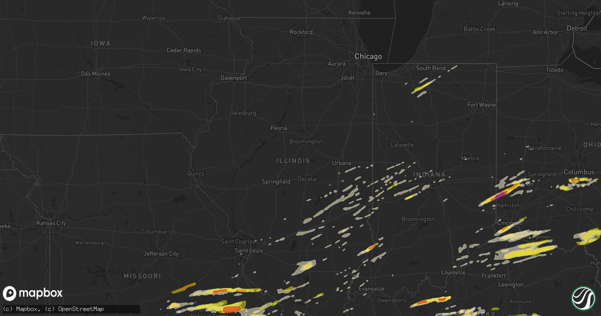
Hail Map in Illinois on April 3, 2018
Get this storm
April 3 map
$229
one time, instant access
Download today. No call, no setup
Keep the $229
Bought the map and want the full workflow? Apply the entire $229 to a subscription within 7 days. None of it is wasted.
Every map, not just this one
This buys you this map. Subscription and you get every map we run, in the markets you choose from a few cities to whole states to nationwide. Plus real-time alerts the moment a storm fires.
Contact data
Name, contact info, occupancy, even credit band for addresses in the footprint. You go from where it hit to who to call.
Become the source they trust
Unlimited branding weather history reports on demand. You already have the documented answer ready for the property owner, and you are the one who showed up with it.
Property data and RoofTrace estimates
Pull up any address you have got, its value and the exact code rules for that jurisdiction, straight from One Click Code. Then RoofTrace estimates the squares, pitch, and roof value, priced the way you price.
Storm reports in Illinois
Illinois
| Date | Description |
|---|---|
| 04/03/20186:38 PM CDT | Confirmed ef-1 tornado with estimated peak winds of 110 mph. Tornado began at 638 pm cdt 5 miles northeast of new haven in white county... Il... And ended at 642 pm cdt |
| 04/03/20186:38 PM CDT | Possible tornado. A semi trailer was tipped over and several irrigation pipes were bent in one 20 acre field. Damage path was 50 yards long. Debris thrown 200-400 yards |
| 04/03/20186:29 PM CDT | Ef-0 tornado with estimated peak winds around 85 mph. Path length was approximately 8 miles... Lifting roughly 6 miles northeast of metropolis near loverkamp road. Nume |
| 04/03/20186:12 PM CDT | Report of tornado and damage to home in the galatia area. ...tornado unconfirmed...9 homes damaged along harper road. 3 to 4 homes destroyed. 2 barns/polebarns damaged. |
| 04/03/20185:53 PM CDT | Reported along interstate 57 |
| 04/03/20185:47 PM CDT | Ef-2 tornado with estimated peak wind of 125 mph and path length of 12.5 miles and maximum path width of 350 yards. Path stretched from 7.5 miles southwest of galatia i |
| 04/03/20185:45 PM CDT | Tree blocking road. |
| 04/03/20185:38 PM CDT | An ef-1 tornado touched down 1 mile north of pittsburg... Travelled 2 miles and lifted 2.5 miles northeast of pittsburg. Peak wind was 95 mph. Maximum path width was 15 |
| 04/03/20185:37 PM CDT | Late report. Illinois state police report comfirmed tornado |
| 04/03/20185:25 PM CDT | Late report. Multiple structures damaged. Reported from video taken by fire/resuce. |
| 04/03/20185:20 PM CDT | Late report. Trees down and metal roof peeled back. |
| 04/03/20185:17 PM CDT | Ef-1 tornado... With peak wind speed of 105 mph was on the ground for 10.25 miles with a maximum width of 125 yards. The tornado path started at 517 pm cdt in cartervil |
| 04/03/20184:55 PM CDT | A local report indicates 72 MPH wind near W DU QUOIN |
| 04/03/20184:55 PM CDT | A local report indicates 1.00 inch wind near 4 W DU QUOIN |
| 04/03/20184:37 PM CDT | Damage to buildings on 200th avenue... Between county road 400 e and county road 500e. |
| 04/03/20184:27 PM CDT | Probable tornado touchdown. 3 homes heavily damaged. |
| 04/03/20184:20 PM CDT | Beginning point of ef2 tornado. |
| 04/03/20188:47 AM CDT | A local report indicates 1.00 inch wind near CHARLESTON |
| 04/03/20187:32 AM CDT | At 1231 PM EDT, severe thunderstorms were located along a line extending from 9 miles northeast of Rockville to near Marshall, moving east at 30 mph. HAZARD...60 mph wind gusts and quarter size hail. SOURCE...Radar indicated. IMPACT...Hail damage to vehicles is expected. Expect wind damage to roofs, siding, and trees. Locations impacted include... Terre Haute, Brazil, Rockville, West Terre Haute, Prairieton, Prairie Creek, Seelyville, Ladoga, Roachdale, Knightsville, Bainbridge, Rosedale, Harmony, New Market, Staunton, Waveland, Carbon, Russellville, Marshall and Riley.This includes Interstate 70 between mile markers 1 and 22. |
| 04/03/20181:19 AM CDT | At 619 PM CDT, a severe thunderstorm was located near La Center, moving east at 35 mph. HAZARD...60 mph wind gusts and quarter size hail. SOURCE...Radar indicated. IMPACT...Hail damage to vehicles is expected. Expect wind damage to roofs, siding, and trees. Locations impacted include... Paducah, Metropolis, La Center, Lone Oak, Brookport, Barlow, Golconda, Karnak, West Paducah, New Columbia, Kevil, Joppa and Hamletsburg. |
| 04/03/201812:20 AM CDT | At 520 PM CDT, a severe thunderstorm was located over Bogota, or near Newton, moving east at 55 mph. HAZARD...60 mph wind gusts. SOURCE...Radar indicated. IMPACT...Expect damage to roofs, siding, and trees. Locations impacted include... Newton, Oblong, Ste. Marie, Willow Hill, Hardinville, Bogota, West Liberty, Hunt City, Stoy, Wakefield, Wendelin, Newton Lake and Sam Parr State Park. |
| 04/03/201812:06 AM CDT | At 505 PM CDT, a severe thunderstorm was located over Mount Vernon, moving east at 45 mph. HAZARD...60 mph wind gusts and half dollar size hail. SOURCE...Radar indicated. IMPACT...Hail damage to vehicles is expected. Expect wind damage to roofs, siding, and trees. Locations impacted include... Mount Vernon, Fairfield, Mount Vernon In Jefferson County, Wayne City, Bluford, Cisne, Dix, Jeffersonville, Sims, Keenes and Johnsonville. |
| 04/02/201811:44 PM CDT | At 443 PM CDT, a severe thunderstorm was located near Ava, or 9 miles northwest of Murphysboro, moving east at 45 mph. HAZARD...60 mph wind gusts and quarter size hail. SOURCE...Radar indicated. IMPACT...Hail damage to vehicles is expected. Expect wind damage to roofs, siding, and trees. Locations impacted include... Murphysboro, Du Quoin, De Soto, Elkville, Ava, Dowell, Campbell Hill, Vergennes and St. Johns. |
| 04/02/201811:34 PM CDT | At 434 PM CDT, a severe thunderstorm was located over Humboldt, or 7 miles northeast of Mattoon, moving east at 60 mph. HAZARD...60 mph wind gusts and quarter size hail. SOURCE...Radar indicated. IMPACT...Hail damage to vehicles is expected. Expect wind damage to roofs, siding, and trees. Locations impacted include... Charleston, Mattoon, Arcola, Oakland, Kansas, Ashmore, Humboldt, Brocton, Hindsboro, Rardin, Isabel, Fairgrange, Bushton and Borton.This includes Interstate 57 between mile markers 190 and 203. |
| 04/02/201811:14 PM CDT | At 411 PM CDT, a severe thunderstorm was located near Findlay, or 7 miles southwest of Sullivan, moving east at 55 mph. HAZARD...60 mph wind gusts and quarter size hail. SOURCE...Radar indicated. IMPACT...Hail damage to vehicles is expected. Expect wind damage to roofs, siding, and trees. Locations impacted include... Mattoon, Sullivan, Windsor, Allenville, Cooks Mill, Coles, Gays, Wolf Creek State Park and Kirksville.This includes Interstate 57 between mile markers 185 and 186. |
| 04/02/201810:26 PM CDT | At 325 PM CDT, a severe thunderstorm was located near Rocky Ridge, moving east at 40 mph. HAZARD...60 mph wind gusts and half dollar size hail. SOURCE...Radar indicated. IMPACT...Hail damage to vehicles is expected. Expect wind damage to roofs, siding, and trees. Locations impacted include... Chester, Ste. Genevieve, Bloomsdale, St. Mary, Rocky Ridge, Weingarten, Ellis Grove, Kaskaskia, Walsh, Kellogg, Roots, Modoc, River Aux Vases and French Village.This includes Interstate 55 in Missouri between exits 143 and 157. This also includes Felix Valle House State Park. |
| 04/02/201810:21 PM CDT | At 321 PM CDT, a severe thunderstorm was located near New Design, moving northeast at 50 mph. HAZARD...60 mph wind gusts and quarter size hail. SOURCE...Radar indicated. IMPACT...Hail damage to vehicles is expected. Expect wind damage to roofs, siding, and trees. Locations impacted include... Freeburg, Red Bud, New Athens, Marissa, Baldwin, New Design, St. Libory, Lenzburg, Hecker, Fayetteville and Burksville. |
| 04/02/20188:32 PM CDT | At 132 PM EDT, a severe thunderstorm was located near St. Francisville, or near Vincennes, moving northeast at 55 mph. HAZARD...60 mph wind gusts and quarter size hail. SOURCE...Radar indicated. IMPACT...Hail damage to vehicles is expected. Expect wind damage to roofs, siding, and trees. Locations impacted include... Vincennes, Linton, Russellville, Bicknell, Lyons, Elnora, Oaktown, Bruceville, Sandborn, Edwardsport, Newberry, Freelandville, Vincennes University and Pleasantville. |
| 04/02/20187:49 PM CDT | A local report indicates 1.00 inch wind near GALATIA |
| 04/02/20187:05 PM CDT | Time unknown...399 customers lost power throughout the county. |
All States Impacted by Hail Map on April 3, 2018
Cities Impacted by Hail Map on April 3, 2018
- Palestine, TX
- Valley Mills, TX
- Gatesville, TX
- Loretto, KY
- Lebanon, KY
- Saint Francis, KY
- Raywick, KY
- Chaffee, MO
- Cape Girardeau, MO
- McClure, IL
- Scott City, MO
- Somerset, OH
- Blue Rock, OH
- New Lexington, OH
- Roseville, OH
- Mcconnelsville, OH
- Crooksville, OH
- Chandlersville, OH
- Philo, OH
- Frankfort, KY
- Sawyer, OK
- Tyler, TX
- Orient, OH
- Grove City, OH
- Florence, KY
- Burlington, KY
- Union, KY
- Latonia, KY
- Ft Mitchell, KY
- Erlanger, KY
- Lesterville, MO
- Centerville, MO
- Bunker, MO
- San Antonio, TX
- Converse, TX
- Tolono, IL
- Brookland, AR
- Waskom, TX
- Bryan, TX
- New Llano, LA
- Leesville, LA
- Campbellsville, KY
- Birch Tree, MO
- Camden, OH
- Jerusalem, AR
- Shirley, AR
- Clinton, AR
- Kevil, KY
- Kempner, TX
- Killeen, TX
- Paragould, AR
- Cardwell, MO
- Melbourne, AR
- Calico Rock, AR
- Vincennes, IN
- Lawrenceville, IL
- Doniphan, MO
- Alton, MO
- Fremont, MO
- Dexter, MO
- Broseley, MO
- Poplar Bluff, MO
- Fisk, MO
- Grandin, MO
- Bernie, MO
- Fairdealing, MO
- Dudley, MO
- Harviell, MO
- Westport, KY
- Marysville, IN
- New Washington, IN
- Charlestown, IN
- Beulah, MO
- Edgar Springs, MO
- Newburg, MO
- Salem, MO
- Lenox, MO
- Duke, MO
- Rolla, MO
- Franklin, TX
- Calvert, TX
- Augusta, AR
- Bradford, AR
- Newport, AR
- Newman, IL
- Hindsboro, IL
- Oakland, IL
- Brocton, IL
- Potosi, MO
- Steelville, MO
- Cash, AR
- Weiner, AR
- Mayslick, KY
- Vanceburg, KY
- Manchester, OH
- Cynthiana, KY
- Aberdeen, OH
- Mount Olivet, KY
- Corinth, KY
- Falmouth, KY
- Berry, KY
- Williamstown, KY
- Brooksville, KY
- Germantown, KY
- Dover, KY
- Maysville, KY
- Augusta, KY
- Leachville, AR
- Steele, MO
- Hornersville, MO
- Blytheville, AR
- Middle Brook, MO
- Doe Run, MO
- Belleview, MO
- Farmington, MO
- Ironton, MO
- Pilot Knob, MO
- Sullivan, IL
- Call, TX
- Joshua, TX
- Cleburne, TX
- Alvarado, TX
- Temple, TX
- Scott, AR
- Little Rock, AR
- North Little Rock, AR
- Ashville, OH
- Lometa, TX
- Cherokee, TX
- Lampasas, TX
- San Saba, TX
- Saint Francisville, IL
- Marquand, MO
- Fredericktown, MO
- Marble Hill, MO
- Patton, MO
- North Liberty, IN
- Walkerton, IN
- Lakeville, IN
- Mount Sterling, OH
- Bloomingburg, OH
- Heber Springs, AR
- Wilburn, AR
- Judsonia, AR
- Pangburn, AR
- Bald Knob, AR
- Middlebury, IN
- Bristol, IN
- Goshen, IN
- Germantown, OH
- Franklin, OH
- Middletown, OH
- Dayton, OH
- Miamisburg, OH
- Sumner, IL
- West Plains, MO
- Pottersville, MO
- Plainfield, IN
- Canmer, KY
- Sweeden, KY
- Mount Sherman, KY
- Bonnieville, KY
- Caneyville, KY
- Summersville, KY
- Roundhill, KY
- Brownsville, KY
- Magnolia, KY
- Cub Run, KY
- Jetson, KY
- Mammoth Cave, KY
- Greensburg, KY
- Munfordville, KY
- Buffalo, KY
- Clarkson, KY
- Bee Spring, KY
- Leitchfield, KY
- Crossville, IL
- Carmi, IL
- Mena, AR
- Boles, AR
- Shreveport, LA
- Chilton, TX
- Caulfield, MO
- Zanoni, MO
- Tecumseh, MO
- Dora, MO
- Carthage, TX
- Plymouth, IN
- West Portsmouth, OH
- Clinton, IN
- Terre Haute, IN
- Bloomfield, MO
- Advance, MO
- Puxico, MO
- Bell City, MO
- Batchelor, LA
- Lettsworth, LA
- De Valls Bluff, AR
- Jonesboro, AR
- Ripley, TN
- Luxora, AR
- Vinton, OH
- Bidwell, OH
- Cheshire, OH
- Gallipolis, OH
- San Ygnacio, TX
- Provencal, LA
- Finley, TN
- Lenox, TN
- Dyersburg, TN
- Jonesboro, TX
- Black, MO
- Bronson, MI
- Saint Louis, MO
- Cave City, KY
- Horse Cave, KY
- Jacksonville, TX
- Bonne Terre, MO
- New Hope, KY
- New Haven, KY
- London, OH
- South Solon, OH
- Jeffersonville, OH
- Dry Ridge, KY
- Ripley, OH
- Russellville, OH
- Foster, KY
- West Union, OH
- Owenton, KY
- Butler, KY
- Sadieville, KY
- New Liberty, KY
- Drew, MS
- Bixby, MO
- Houston, TX
- Hodgenville, KY
- Springfield, KY
- Whitehouse, TX
- Alicia, AR
- Hoxie, AR
- Eaton, OH
- Eldorado, OH
- West Manchester, OH
- Liberty, IN
- Richmond, IN
- Lewisburg, OH
- Jackson, MO
- Senatobia, MS
- Hustonville, KY
- Middleburg, KY
- Farina, IL
- Robinson, IL
- Hazen, AR
- Sandgap, KY
- McKee, KY
- Alexandria, KY
- Morning View, KY
- Independence, KY
- Mount Pleasant, AR
- Radcliff, KY
- La Grange, KY
- Tunica, MS
- Dundee, MS
- Burkeville, TX
- North Salem, IN
- Roachdale, IN
- French Village, MO
- Wesco, MO
- Cook Sta, MO
- Bloomsdale, MO
- Valles Mines, MO
- Cadet, MO
- Mineral Point, MO
- Cherryville, MO
- Sainte Genevieve, MO
- Harrisburg, AR
- Bay, AR
- Lake City, AR
- Trumann, AR
- Lepanto, AR
- Marked Tree, AR
- Smithville, AR
- Fort Thomas, KY
- Covington, KY
- Newport, KY
- Sellersburg, IN
- Jeffersonville, IN
- Clarksville, IN
- Liberty, KY
- Vandervoort, AR
- Cove, AR
- Wickes, AR
- Flatonia, TX
- Smithville, TX
- Waltonville, IL
- Ashley, IL
- Woodlawn, IL
- Texico, IL
- Mount Vernon, IL
- Dix, IL
- Fifty Six, AR
- Harriet, AR
- Batesville, AR
- Guion, AR
- Mountain View, AR
- Sidney, AR
- Sage, AR
- Evening Shade, AR
- Cave City, AR
- Horseshoe Bend, AR
- Big Flat, AR
- Poughkeepsie, AR
- South Webster, OH
- Wheelersburg, OH
- Mannsville, KY
- Bradfordsville, KY
- Morgantown, KY
- Smiths Grove, KY
- Elk Horn, KY
- Gravel Switch, KY
- Bowling Green, KY
- Rogers, TX
- Buckholts, TX
- Oglesby, TX
- Willow Springs, MO
- Petersburg, IN
- Washington, IN
- Patoka, IN
- Hazleton, IN
- Monroe City, IN
- Damascus, AR
- Oak Hill, OH
- Rio Grande, OH
- Letart, WV
- Middleport, OH
- West Columbia, WV
- Thurman, OH
- Florien, LA
- California, KY
- Evans, LA
- Newton, TX
- Wiergate, TX
- Deridder, LA
- Georgetown, OH
- Hamersville, OH
- Thebes, IL
- Leopold, MO
- Whitewater, MO
- Brodhead, KY
- Stanford, KY
- Mount Vernon, KY
- Berea, KY
- Waynesburg, KY
- Crab Orchard, KY
- Orlando, KY
- Vincent, KY
- Kings Mountain, KY
- Hamburg, AR
- Floral, AR
- Drasco, AR
- Caraway, AR
- Concord, AR
- Rosie, AR
- Magness, AR
- Osceola, AR
- Locust Grove, AR
- Newark, AR
- Sulphur Rock, AR
- Desha, AR
- Dyess, AR
- Tuckerman, AR
- Bruceville, IN
- Edwardsville, IL
- Ellsinore, MO
- Greenfield, TN
- Strawberry, AR
- Westfield, IL
- Casey, IL
- Metropolis, IL
- Brookshire, TX
- Allendale, IL
- Mount Carmel, IL
- Moody, TX
- Ingraham, IL
- Noble, IL
- Clay City, IL
- Ladoga, IN
- Upton, KY
- Big Clifty, KY
- Sonora, KY
- Wilson, AR
- Swifton, AR
- Amagon, AR
- Pleasant Plains, AR
- Burnt Prairie, IL
- Golden Gate, IL
- Marks, MS
- Lambert, MS
- Simmesport, LA
- Jackson, OH
- Lucasville, OH
- Minford, OH
- Portsmouth, OH
- Bicknell, IN
- Oaktown, IN
- Edwardsport, IN
- Norris City, IL
- Milford, TX
- Rusk, TX
- Fort Polk, LA
- Pitkin, LA
- New Haven, WV
- Mason, WV
- Thornton, TX
- Marlin, TX
- Groesbeck, TX
- Kosse, TX
- Riesel, TX
- Bremen, IN
- Dover, AR
- Pelsor, AR
- Dennard, AR
- Cincinnati, OH
- Hillsboro, TX
- Caddo Gap, AR
- La Vernia, TX
- Adkins, TX
- Stockdale, TX
- Seguin, TX
- Nixon, TX
- Sparta, TN
- Walling, TN
- Rock Island, TN
- Doyle, TN
- Quebeck, TN
- Portland, OH
- Ravenswood, WV
- Evansville, IN
- Bauxite, AR
- Naylor, MO
- Jbsa Ft Sam Houston, TX
- Saint Hedwig, TX
- West Union, WV
- New Milton, WV
- College Corner, OH
- West College Corner, IN
- Oxford, OH
- Bath, IN
- Charleston, IL
- Ashmore, IL
- Stewardson, IL
- Mattoon, IL
- Neoga, IL
- Gays, IL
- Trilla, IL
- Windsor, IL
- Kansas, IL
- Lerna, IL
- Paris, IL
- Arlington, TX
- Grand Prairie, TX
- Bon Wier, TX
- Grand Chain, IL
- Villa Ridge, IL
- Olmsted, IL
- Alexander, AR
- Mabelvale, AR
- Dana, IN
- Chrisman, IL
- West Harrison, IN
- Bedias, TX
- Iola, TX
- De Witt, AR
- Scurry, TX
- Ennis, TX
- West Alexandria, OH
- Harrisburg, OH
- Williamsport, OH
- Lockbourne, OH
- Commercial Point, OH
- Beckville, TX
- Marshall, TX
- Bismarck, MO
- Boss, MO
- Arcadia, MO
- Hardinsburg, KY
- Cloverport, KY
- Cecilia, KY
- Irvington, KY
- Garfield, KY
- Vine Grove, KY
- Elizabethtown, KY
- Falls Of Rough, KY
- West Point, KY
- Rineyville, KY
- Westview, KY
- Custer, KY
- Fordsville, KY
- Harned, KY
- De Soto, MO
- Laurel, IN
- Metamora, IN
- New Lebanon, OH
- Farmersville, OH
- Somerville, OH
- Brookville, IN
- Sedgewickville, MO
- London, KY
- Annville, KY
- Bono, AR
- Arbyrd, MO
- Canal Winchester, OH
- Lancaster, OH
- Amanda, OH
- Baltimore, OH
- Lithopolis, OH
- Columbus, OH
- Carroll, OH
- Groveport, OH
- Oran, MO
- Zalma, MO
- Sturdivant, MO
- Cameron, WV
- Wind Ridge, PA
- Holbrook, PA
- Aleppo, PA
- Clayton, IN
- Rison, AR
- Circleville, OH
- Rockville, IN
- Carbon, IN
- Searcy, AR
- Rose Bud, AR
- Quitman, AR
- Pearcy, AR
- Bonnerdale, AR
- Hot Springs National Park, AR
- Mart, TX
- Essex, MO
- Mill Shoals, IL
- Waldron, AR
- Batesville, IN
- Sunman, IN
- Sutherland Springs, TX
- Fox, AR
- Edgemont, AR
- Hector, AR
- Wallis, TX
- Sealy, TX
- Yorktown, IN
- Makanda, IL
- Cobden, IL
- Anna, IL
- Mcminnville, TN
- Hillsboro, IN
- Waynetown, IN
- Veedersburg, IN
- Kingman, IN
- Saint James, MO
- Davisville, MO
- Belgrade, MO
- Manila, AR
- Halls, TN
- Dell, AR
- Gates, TN
- Paris, TX
- Flora, IL
- Stamping Ground, KY
- Pleasureville, KY
- Lockport, KY
- Marianna, AR
- Poplar Grove, AR
- Lexa, AR
- Cat Spring, TX
- Alleyton, TX
- Huntsville, TX
- Madisonville, TX
- Van Buren, MO
- Redford, MO
- Ellington, MO
- Lodi, MO
- Patterson, MO
- Vulcan, MO
- Greenville, MO
- Silva, MO
- Des Arc, MO
- Clubb, MO
- Piedmont, MO
- Eddy, TX
- Bruceville, TX
- Lorena, TX
- Annapolis, MO
- Carlisle, AR
- Pasadena, TX
- Indianapolis, IN
- Mccordsville, IN
- Heavener, OK
- Concepcion, TX
- South Shore, KY
- Haworth, OK
- Tamms, IL
- Brookville, OH
- Rosebud, TX
- Spring Valley, OH
- Bellbrook, OH
- Xenia, OH
- Waterloo, IL
- Blossom, TX
- Crawfordsville, IN
- Bokchito, OK
- Bennington, OK
- Madison, IN
- Vevay, IN
- Bedford, KY
- Milton, KY
- Sikeston, MO
- Matthews, MO
- Albion, IL
- Coldwater, MS
- Hernando, MS
- Bremond, TX
- Verona, KY
- Crittenden, KY
- Winchester, OH
- Florence, IN
- Warsaw, KY
- Walton, KY
- Bethel, OH
- New Richmond, OH
- Patriot, IN
- Sardinia, OH
- De Mossville, KY
- Moscow, OH
- Gainesville, MO
- Kinmundy, IL
- Saint Peter, IL
- Edgewood, IL
- Dale, IN
- Neelyville, MO
- Stonewall, LA
- Smithville, TN
- Broken Bow, OK
- Itasca, TX
- Rosedale, IN
- Sturgis, KY
- Buncombe, IL
- Como, MS
- Bunkie, LA
- Cottonport, LA
- Oblong, IL
- Martinsville, IL
- Annapolis, IL
- West York, IL
- Highland, IL
- Pocahontas, IL
- Murphysboro, IL
- De Soto, IL
- Elkville, IL
- West Fork, AR
- Prairie Grove, AR
- Winslow, AR
- North Bend, OH
- Hebron, KY
- Cleves, OH
- Detroit, TX
- Powderly, TX
- Oldenburg, IN
- Honobia, OK
- Smithville, OK
- Brookeland, TX
- Jasper, TX
- Keithville, LA
- Newton, IL
- Ramsey, IL
- Brownstown, IL
- Beecher City, IL
- Cowden, IL
- Westville, IL
- Versailles, IN
- Dillsboro, IN
- Merryville, LA
- Midway, TX
- Monrovia, IN
- Stilesville, IN
- Cloverdale, IN
- Martinsville, IN
- Glenallen, MO
- Friedheim, MO
- Daisy, MO
- Pomona, MO
- Keene, TX
- Saint Jacob, IL
- Marine, IL
- Princeton, LA
- Haughton, LA
- Idaville, IN
- Shelbyville, IL
- Assumption, IL
- Timpson, TX
- Athens, LA
- Fort Knox, KY
- Maynard, AR
- Success, AR
- Reklaw, TX
- Laneville, TX
- Seabrook, TX
- Webster, TX
- Bellaire, TX
- La Porte, TX
- Pearland, TX
- South Houston, TX
- Sanders, KY
- Sparta, KY
- Amelia, OH
- Ghent, KY
- Felicity, OH
- Keatchie, LA
- Thompsonville, IL
- Knox, IN
- Grovertown, IN
- Marshall, IL
- Dennison, IL
- West Terre Haute, IN
- Brickeys, AR
- Robinsonville, MS
- Sextons Creek, KY
- Manchester, KY
- Spencer, TN
- Hillsdale, IN
- Success, MO
- Rosston, AR
- Reelsville, IN
- Danville, IN
- Fillmore, IN
- Greencastle, IN
- Coatesville, IN
- Brazil, IN
- Amo, IN
- Ragsdale, IN
- Glendale, KY
- Holly Springs, MS
- Muse, OK
- Whitesboro, OK
- Hodgen, OK
- Ivanhoe, TX
- New Castle, KY
- Eminence, KY
- Bethlehem, KY
- Holland, TX
- Moody, MO
- Greenville, IL
- Qulin, MO
- Mount Judea, AR
- Alhambra, IL
- Alma, IL
- Morganfield, KY
- Poteau, OK
- Witts Springs, AR
- Hagarville, AR
- Irving, TX
- Hanna, IN
- Wanatah, IN
- Union Mills, IN
- Lonoke, AR
- Ravenden Springs, AR
- Nacogdoches, TX
- Mount Enterprise, TX
- Cushing, TX
- Bloomingdale, IN
- Montezuma, IN
- Walnut Ridge, AR
- Monette, AR
- Lynn, AR
- Cooter, MO
- Powhatan, AR
- Marshall, AR
- Farmersburg, IN
- Piqua, OH
- Copperas Cove, TX
- Sidell, IL
- Metcalf, IL
- Hume, IL
- West Union, IL
- New Harmony, IN
- Poseyville, IN
- Griffin, IN
- Altamont, IL
- Watson, IL
- Teague, TX
- Dallas, TX
- Bossier City, LA
- Sims, IL
- Keenes, IL
- Johnsonville, IL
- Saint Francisville, LA
- Darlington, IN
- Olney, IL
- Greenwood, LA
- Troy, OH
- Englewood, OH
- West Milton, OH
- Tipp City, OH
- Briggs, TX
- Anna, OH
- Arthur, IL
- Decker, IN
- Byhalia, MS
- Nashoba, OK
- Bonita, LA
- Jones, LA
- Evergreen, LA
- Carterville, IL
- Cambria, IL
- Carbondale, IL
- Canehill, AR
- Saint Joe, AR
- Tichnor, AR
- Greenfield, IN
- Park Hills, MO
- Stuttgart, AR
- Bryant, AR
- Fairborn, OH
- Willow Hill, IL
- Pinckneyville, IL
- Pittsboro, IN
- Toledo, IL
- Greenup, IL
- West Liberty, IL
- Dundas, IL
- Malvern, AR
- Sabina, OH
- Leesburg, OH
- Cross Plains, IN
- Sesser, IL
- Benton, IL
- Mulkeytown, IL
- Whittington, IL
- Du Quoin, IL
- Brookport, IL
- McGregor, TX
- Frierson, LA
- Muncie, IN
- Vergennes, IL
- Ava, IL
- Campbell Hill, IL
- Percy, IL
- Sumner, MS
- Tutwiler, MS
- Morocco, IN
- Granite City, IL
- Hartford, IL
- East Alton, IL
- Clayton, OH
- Ullin, IL
- Fort Hood, TX
- Anacoco, LA
- Zionsville, IN
- Whitestown, IN
- Catron, MO
- Altenburg, MO
- Old Appleton, MO
- Uniontown, MO
- Frohna, MO
- Oak Ridge, MO
- Rosanky, TX
- Millersville, MO
- Perryville, MO
- Caledonia, MO
- Licking, MO
- East Bernstadt, KY
- Smithfield, KY
- Cedar Grove, IN
- Oakwood, TX
- Fairfield, TX
- Farrar, MO
- Golconda, IL
- Warm Springs, AR
- Carrollton, TX
- Kemp, TX
- Burleson, TX
- Westfield, IN
- Mode, IL
- White Mills, KY
- Humboldt, IL
- Arcola, IL
- Tow, TX
- Bluffton, TX
- Llano, TX
- Elkins, AR
- Combs, AR
- Grayville, IL
- Dubach, LA
- Milford, OH
- Batavia, OH
- England, AR
- Rossburg, OH
- Ansonia, OH
- Waveland, IN
- Arthur City, TX
- Bagwell, TX
- Evansville, AR
- Fayetteville, AR
- Monterey, IN
- Culver, IN
- Turners Station, KY
- Worthville, KY
- Campbellsburg, KY
- New Vienna, OH
- Beaver, OH
- McDermott, OH
- Point Pleasant, WV
- Owensville, IN
- Thorntown, IN
- Barlow, KY
- La Center, KY
- Mounds, IL
- Pulaski, IL
- Olive Branch, IL
- Karnak, IL
- Karnack, TX
- Effingham, IL
- Williamsville, MO
- El Dorado, AR
- Bee Branch, AR
- Clarendon, AR
- Brinkley, AR
- Lufkin, TX
- Benavides, TX
- London, AR
- De Berry, TX
- Williford, AR
- Hardy, AR
- Rosine, KY
- Horse Branch, KY
- Olaton, KY
- Gillett, AR
- Marshall, IN
- Jacob, IL
- Marion, IL
- Pollok, TX
- Plato, MO
- Belton, TX
- Normangee, TX
- Corydon, KY
- Cave In Rock, IL
- Lyon, MS
- Minden, LA
- Ringgold, LA
- Crockett, TX
- Batesville, MS
- Dieterich, IL
- Imperial, MO
- Du Bois, IL
- Richview, IL
- Walnut Hill, IL
- Centralia, IL
- Bluford, IL
- Tamaroa, IL
- Hillsboro, IL
- Friendswood, TX
- Prim, AR
- New Market, IN
- Wakarusa, IN
- Yellow Springs, OH
- Villa Grove, IL
- Camargo, IL
- Chireno, TX
- San Augustine, TX
- Black Rock, AR
- Sidney, OH
- Proctor, WV
- Franklin, IN
- Shelbyville, IN
- Maplewood, OH
- Bainbridge, IN
- Russellville, IN
- Newbern, TN
- Oil Trough, AR
- Gould, AR
- Allen, MI
- Litchfield, MI
- Quincy, MI
- Festus, MO
- Mount Vernon, IN
- Wadesville, IN
- Hornbeck, LA
- Red Banks, MS
- Cleveland, AR
- Center Ridge, AR
- Chester, IL
- Rio Vista, TX
- Plaucheville, LA
- Fairmount, IL
- Garrison, TX
- Black Oak, AR
- Moro, AR
- Junction City, AR
- Sidney, IL
- Homer, IL
- Philo, IL
- Benton, AR
- Crossville, TN
- Coldwater, MI
- North Zulch, TX
- Pittsburg, IL
- Galatia, IL
- Danville, IL
- Perrysville, IN
- Marion, LA
- Kirbyville, TX
- Mooresville, IN
- Avon, IN
- Lott, TX
- Mulberry Grove, IL
- Vandalia, IL
- Shobonier, IL
- Saint Elmo, IL
- Crestwood, KY
- Prospect, KY
- Tollesboro, KY
- Holly Grove, AR
- Lexington, IN
- Hanover, IN
- Nabb, IN
- Houston, MO
- Eastview, KY
- Mexia, TX
- Burnet, TX
- Schertz, TX
- Washington Court House, OH
- Syracuse, OH
- Hartford, WV
- Racine, OH
- Salem, WV
- Goshen, OH
- Huntsville, AR
- Ozark, AR
- Saffell, AR
- Scotland, AR
- Choctaw, AR
- Higden, AR
- Hensley, AR
- Marcella, AR
- Senath, MO
- McCrory, AR
- Beedeville, AR
- Etowah, AR
- Jonesboro, IL
- Cypress, IL
- Dongola, IL
- Madisonville, KY
- Earlington, KY
- Hardyville, KY
- Danville, KY
- Parksville, KY
- Junction City, KY
- Cuba, MO
- Nashville, TN
- Hermitage, TN
- Antioch, TN
- Franklin, TN
- Mount Juliet, TN
- Brentwood, TN
- La Vergne, TN
- Lebanon, TN
- Old Hickory, TN
- Watertown, TN
- Riddleton, TN
- Adams, TN
- Cedar Hill, TN
- Springfield, TN


