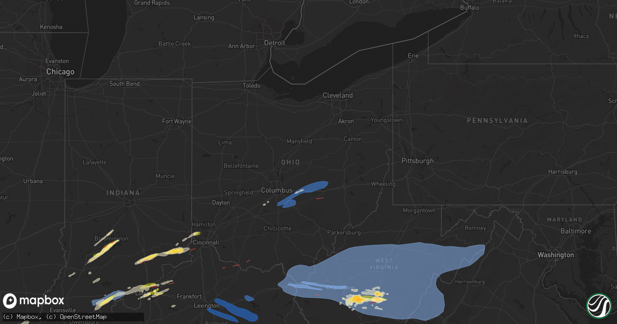
Hail Map in Ohio on April 2, 2024
Get this storm
April 2 map
$229
one time, instant access
Download today. No call, no setup
Keep the $229
Bought the map and want the full workflow? Apply the entire $229 to a subscription within 7 days. None of it is wasted.
Every map, not just this one
This buys you this map. Subscription and you get every map we run, in the markets you choose from a few cities to whole states to nationwide. Plus real-time alerts the moment a storm fires.
Contact data
Name, contact info, occupancy, even credit band for addresses in the footprint. You go from where it hit to who to call.
Become the source they trust
Unlimited branding weather history reports on demand. You already have the documented answer ready for the property owner, and you are the one who showed up with it.
Property data and RoofTrace estimates
Pull up any address you have got, its value and the exact code rules for that jurisdiction, straight from One Click Code. Then RoofTrace estimates the squares, pitch, and roof value, priced the way you price.
Storm reports in Ohio
Ohio
| Date | Description |
|---|---|
| 04/02/20246:55 PM CDT | Debris and trees down on the road near chapparal rd and oh-247. Time estimated from radar. |
| 04/02/20246:52 PM CDT | Time estimated from radar. |
| 04/02/20246:46 PM CDT | *** 1 inj *** ef1 tornado destroyed one structure and damaged several others... With numerous trees snapped and uprooted. Maximum estimated wind speeds of 100 mph. |
| 04/02/20246:38 PM CDT | A local report indicates a tornado near Ripley |
| 04/02/20245:07 PM CDT | Time estimated from radar. |
| 04/02/20245:07 PM CDT | 1 large tree down. Time estimated from radar. |
| 04/02/20244:50 PM CDT | A local report indicates 1.00 inch wind near 2 NNE Grandview |
| 04/02/20249:40 AM CDT | Out buildings destroyed and several trees down... Some onto structures. |
| 04/02/20249:37 AM CDT | Rear half of proctorville fd destroyed. Roof partially removed from fairland west elementary school. Damage consistent with microburst. Estimated wind speeds of 90 mph. |
| 04/02/20249:36 AM CDT | Significant damage reported across the town with roofs blown off... 1-2 ft diameter trees down... Rear half of fire dept destroyed. |
| 04/02/20249:36 AM CDT | Part of the roof of elementary school blown off. |
| 04/02/20249:35 AM CDT | Proctorville fire department building destroyed with severe damage to other structures. |
| 04/02/20249:34 AM CDT | Multiple power poles snapped midway up along north kenova rd. |
| 04/02/20249:30 AM CDT | Several trees down and structures damaged in aid township. |
| 04/02/20249:30 AM CDT | Widespread tree and power line damage. Multiple structures with damage. Truck overturned on proctorville bridge. |
| 04/02/20249:26 AM CDT | An ef1 tornado with maximum winds of up to 90 mph began near aid-oak ridge rd and traveled northeastward through mostly pastureland... Knocking down a few trees on the |
| 04/02/20249:23 AM CDT | Several trees snapped or uprooted along state route 141 near sugar creek christian academy. |
| 04/02/20249:20 AM CDT | Several campers flipped over and structures damaged. |
| 04/01/20248:20 PM CDT | Tornado confirmed on coon ridge road near wonderland road. Tornado speed... Width... Intensity... And path are still being evaluated. |
| 04/01/20248:18 PM CDT | Damage to trees reported near chandlersville. Additional details on damage and location forthcoming after initial evaluation by local fire department. |
| 04/01/20247:59 PM CDT | Tornado confirmed along cowden road. Tornado speed... Width... Intensity... And path is still being considered following yesterday's survey. We are evaluating whether t |
| 04/01/20247:58 PM CDT | Damage to trees and outbuilding associated with a possible tornado. A narrow swath of damage to be evaluated by a storm damage survey team. |
| 04/01/20247:57 PM CDT | An ef1 tornado touched down on april 2... 2024 along cowden road. The maximum wind speed was 100mph... Width was 75yrds... And length was 1.3 miles. |
| 04/01/20247:51 PM CDT | Tree and power lines reported down near the intersection of oakland road and rock run road. |
| 04/01/20247:51 PM CDT | Tree reported down near the intersection of oakland road and roberts road. |
| 04/01/20247:49 PM CDT | An ef0 tornado touched down on april 2...2024 in highland twp. Maximum winds were 85mph... Width was 50 yrds... And path length was 1.2 miles. |
| 04/01/20247:47 PM CDT | The tornado began along erwin hollow rd where several hardwood trees were snapped and uprooted. The tornado then moved northeast over a thick forest of mixed pine and h |
| 04/01/20247:45 PM CDT | Roof damage reported. Trees down |
| 04/01/20247:44 PM CDT | Part of a narrow swath of wind damage from a possible tornado... To be evaluated by storm damage survey team. |
| 04/01/20247:40 PM CDT | Report of down trees on house along route 93 north of pleasant grove. Time estimated based on radar. |
| 04/01/20247:32 PM CDT | A narrow swath of roof... Barn and tree damage associated with a possible tornado in vicinity of parr airport... To be evaluated by storm damage survey team. |
| 04/01/20247:30 PM CDT | Tornado confirmed near north zanesville. Tornado speed... Width... And path is still to be determined. |
| 04/01/20247:18 PM CDT | Tree damage reported associated with a possible tornado... To be evaluated by a storm damage survey team. |
| 04/01/20247:15 PM CDT | Several trees down. |
| 04/01/20247:12 PM CDT | Tree uprooted. Time estimated from radar. |
| 04/01/20247:08 PM CDT | Trees uprooted on property on fairview road. No structural damage. Time estimated from radar. |
| 04/01/20247:08 PM CDT | Another damage report on fairview road |
| 04/01/20247:08 PM CDT | An ef0 tornado damaged numerous trees... And caused minor structural damage to a barn and a few outbuildings. Maximum estimated wind speed of 75 mph. |
All States Impacted by Hail Map on April 2, 2024
Cities Impacted by Hail Map on April 2, 2024
- Watson, AR
- Brickeys, AR
- Hughes, AR
- Gunnison, MS
- Tunica, MS
- Lake Cormorant, MS
- Robinsonville, MS
- Bernice, LA
- Hernando, MS
- Nesbit, MS
- Snow Lake, AR
- Duncan, MS
- Olive Branch, MS
- Southaven, MS
- Walls, MS
- Memphis, TN
- Horn Lake, MS
- Byhalia, MS
- Cordova, TN
- Collierville, TN
- Germantown, TN
- Paris, KY
- Winchester, KY
- Mount Sterling, KY
- Lexington, KY
- Richmond, KY
- Irvine, KY
- Waco, KY
- Clay City, KY
- Jeffersonville, KY
- Stanton, KY
- Morehead, KY
- Salt Lick, KY
- Hillsboro, KY
- Owingsville, KY
- Means, KY
- Frenchburg, KY
- Ravenna, KY
- Slade, KY
- Wellington, KY
- Denniston, KY
- Campton, KY
- Ezel, KY
- Hazel Green, KY
- Kirbyville, TX
- Russell, KY
- Pedro, OH
- Ironton, OH
- Worthington, KY
- Flatwoods, KY
- Ashland, KY
- Kitts Hill, OH
- Willow Wood, OH
- South Point, OH
- Catlettsburg, KY
- Kenova, WV
- Prichard, WV
- Chesapeake, OH
- Ceredo, WV
- Huntington, WV
- Argillite, KY
- Rush, KY
- Grayson, KY
- Greenup, KY
- Fort Gay, WV
- Wayne, WV
- Louisa, KY
- Denton, KY
- East Lynn, WV
- Genoa, WV
- Lavalette, WV
- Branchland, WV
- Barboursville, WV
- Scottown, OH
- Proctorville, OH
- Ona, WV
- Glenwood, WV
- Apple Grove, WV
- Crown City, OH
- Gallipolis, OH
- West Hamlin, WV
- Waterloo, OH
- Salt Rock, WV
- Lesage, WV
- Milton, WV
- Ashton, WV
- Patriot, OH
- Newton, TX
- Harrisburg, IL
- Bethel Springs, TN
- Finger, TN
- Griffithsville, WV
- Midkiff, WV
- Culloden, WV
- Spurlockville, WV
- Hurricane, WV
- Ranger, WV
- Alkol, WV
- Myra, WV
- Hamlin, WV
- Eleanor, WV
- Yawkey, WV
- Scott Depot, WV
- Red House, WV
- Sod, WV
- Winfield, WV
- Saint Albans, WV
- Fraziers Bottom, WV
- Buffalo, WV
- Sardis, TN
- Burkeville, TX
- Evans, LA
- Deridder, LA
- Lexington, TN
- Merryville, LA
- Leesville, LA
- Enville, TN
- Reagan, TN
- Tornado, WV
- Sumerco, WV
- Julian, WV
- Ridgeview, WV
- Alum Creek, WV
- Nitro, WV
- Charleston, WV
- Ashford, WV
- Poca, WV
- Dunbar, WV
- Racine, WV
- Hernshaw, WV
- Bloomingrose, WV
- Comfort, WV
- Orgas, WV
- South Charleston, WV
- Cabin Creek, WV
- Winifrede, WV
- Nellis, WV
- Seth, WV
- Costa, WV
- Peytona, WV
- Eskdale, WV
- Tad, WV
- Elkview, WV
- Belle, WV
- Leon, WV
- Liberty, WV
- Darden, TN
- Parsons, TN
- Decaturville, TN
- Fort Polk, LA
- Scotts Hill, TN
- Bath Springs, TN
- Foster, WV
- Miami, WV
- Drybranch, WV
- East Bank, WV
- Glasgow, WV
- Blount, WV
- Cedar Grove, WV
- Hansford, WV
- Gallagher, WV
- London, WV
- Hugheston, WV
- Mammoth, WV
- Montgomery, WV
- Handley, WV
- Clendenin, WV
- Pratt, WV
- Kenna, WV
- Glen, WV
- Smithers, WV
- Swiss, WV
- Bickmore, WV
- Indore, WV
- Procious, WV
- Dixie, WV
- Powellton, WV
- Maysel, WV
- Pond Gap, WV
- Bomont, WV
- Wallback, WV
- Mount Carbon, WV
- Kimberly, WV
- Clay, WV
- Lizemores, WV
- Belva, WV
- Fayetteville, WV
- Kanawha Falls, WV
- Scarbro, WV
- Kincaid, WV
- Robson, WV
- Gauley Bridge, WV
- Linden, TN
- Pitkin, LA
- Mount Hope, WV
- Oak Hill, WV
- Ansted, WV
- Victor, WV
- Summersville, WV
- Drennen, WV
- Duck, WV
- Hico, WV
- Lansing, WV
- Glen Jean, WV
- Lookout, WV
- Thurmond, WV
- Edmond, WV
- Centerville, TN
- Monroe City, IN
- Lobelville, TN
- Wheatland, IN
- Washington, IN
- Nunnelly, TN
- Birch River, WV
- Dille, WV
- Frametown, WV
- Danese, WV
- Mount Lookout, WV
- Camden On Gauley, WV
- Calvin, WV
- Mount Nebo, WV
- Erbacon, WV
- Rainelle, WV
- Nallen, WV
- Quinwood, WV
- Tioga, WV
- Cowen, WV
- Craigsville, WV
- Pool, WV
- Nettie, WV
- Canvas, WV
- Leivasy, WV
- Fenwick, WV
- Webster Springs, WV
- Upperglade, WV
- Richwood, WV
- Charmco, WV
- Rupert, WV
- Meadow Bridge, WV
- Renick, WV
- Maxwelton, WV
- Crawley, WV
- Hillsboro, WV
- Smoot, WV
- Williamsburg, WV
- Alderson, WV
- Grassy Meadows, WV
- Asbury, WV
- Lewisburg, WV
- Montgomery, IN
- Odon, IN
- Loogootee, IN
- Duck River, TN
- Lyles, TN
- Crane, IN
- Frankford, WV
- White Sulphur Springs, WV
- Marlinton, WV
- Slatyfork, WV
- Cass, WV
- Valley Head, WV
- Buckeye, WV
- Primm Springs, TN
- Bloomfield, IN
- Springville, IN
- Owensburg, IN
- Bloomington, IN
- Troy, IN
- Lewisport, KY
- Tell City, IN
- Evanston, IN
- Grandview, IN
- Fairview, TN
- Bon Aqua, TN
- Covington, VA
- Dunmore, WV
- Hot Springs, VA
- Warm Springs, VA
- Millboro, VA
- Bacova, VA
- Green Bank, WV
- Monterey, VA
- Selma, VA
- Arbovale, WV
- Eagle Rock, VA
- Clifton Forge, VA
- Williamsville, VA
- McDowell, VA
- Iron Gate, VA
- Head Waters, VA
- Deerfield, VA
- Goshen, VA
- Doe Hill, VA
- Williamsport, TN
- Scottsville, KY
- Franklin, TN
- Santa Fe, TN
- Nashville, TN
- Branchville, IN
- Leopold, IN
- Bristow, IN
- Bedford, IN
- English, IN
- Saint Croix, IN
- Sulphur, IN
- Brentwood, TN
- Lucas, KY
- Glasgow, KY
- Rockbridge Baths, VA
- Lexington, VA
- West Augusta, VA
- Bergoo, WV
- Monterville, WV
- Bartow, WV
- Durbin, WV
- Huttonsville, WV
- Gallipolis Ferry, WV
- Henderson, WV
- Southside, WV
- Cottageville, WV
- Given, WV
- Ripley, WV
- Evans, WV
- Spencer, WV
- Le Roy, WV
- Advent, WV
- Sandyville, WV
- Reedy, WV
- Gandeeville, WV
- Gay, WV
- Palestine, WV
- Walton, WV
- Creston, WV
- Arnoldsburg, WV
- Grantsville, WV
- Big Bend, WV
- Mount Zion, WV
- Ravenswood, WV
- Elizabeth, WV
- Brohard, WV
- Macfarlan, WV
- Munday, WV
- Big Springs, WV
- Millstone, WV
- Alum Bridge, WV
- Chloe, WV
- Amma, WV
- Smithville, WV
- Looneyville, WV
- Orma, WV
- Troy, WV
- Shock, WV
- Linn, WV
- Left Hand, WV
- Coxs Mills, WV
- Normantown, WV
- Glenville, WV
- Newton, WV
- Nebo, WV
- Exchange, WV
- Copen, WV
- Sand Fork, WV
- Rosedale, WV
- Weston, WV
- Burnsville, WV
- Orlando, WV
- Jane Lew, WV
- Ivydale, WV
- Cedarville, WV
- Camden, WV
- Gassaway, WV
- Walkersville, WV
- Sutton, WV
- Napier, WV
- Buckhannon, WV
- Heaters, WV
- Flatwoods, WV
- Horner, WV
- Ireland, WV
- Ellamore, WV
- Adrian, WV
- Little Birch, WV
- Volga, WV
- French Creek, WV
- Philippi, WV
- Crawford, WV
- Rock Cave, WV
- Cleveland, WV
- Belington, WV
- Kanawha Head, WV
- Coalton, WV
- Selbyville, WV
- Hacker Valley, WV
- Diana, WV
- Montrose, WV
- Tallmansville, WV
- Mill Creek, WV
- Norton, WV
- Mabie, WV
- Hambleton, WV
- Elkins, WV
- Parsons, WV
- Pickens, WV
- Kerens, WV
- Helvetia, WV
- Thomas, WV
- Valley Bend, WV
- Beverly, WV
- Hendricks, WV
- Bowden, WV
- Cabins, WV
- Petersburg, WV
- Harman, WV
- Keyser, WV
- Seneca Rocks, WV
- Glady, WV
- Red Creek, WV
- Davis, WV
- Dryfork, WV
- Old Fields, WV
- Mount Storm, WV
- Whitmer, WV
- Maysville, WV
- Lahmansville, WV
- Milam, WV
- Delray, WV
- Riverton, WV
- Fisher, WV
- Rio, WV
- Moorefield, WV
- Sugar Grove, WV
- Upper Tract, WV
- Franklin, WV
- Brandywine, WV
- Circleville, WV
- Mathias, WV
- Blue Grass, VA
- Romney, WV
- Baker, WV
- Edinburg, VA
- Dayton, VA
- Wardensville, WV
- Yellow Spring, WV
- Basye, VA
- Fulks Run, VA
- Lost City, WV
- Criders, VA
- Star Tannery, VA
- Bergton, VA
- High View, WV
- Capon Bridge, WV
- Orkney Springs, VA
- Broadway, VA
- Hinton, VA
- Winchester, VA
- Craigsville, VA
- Bridgewater, VA
- Maurertown, VA
- Harrisonburg, VA
- Woodstock, VA
- Singers Glen, VA
- Mount Jackson, VA
- Quicksburg, VA
- Mount Solon, VA
- Swoope, VA
- Churchville, VA
- Linville, VA
- Timberville, VA
- New Market, VA
- Summer Shade, KY
- Eighty Eight, KY
- Antioch, TN
- Nashville, IN
- Cape Girardeau, MO
- Edmonton, KY
- Jackson, MO
- Lecompte, LA
- Forest Hill, LA
- Pleasant Shade, TN
- Carthage, TN
- Riddleton, TN
- Lebanon, TN
- Alto Pass, IL
- Wolf Lake, IL
- Jonesboro, IL
- Cobden, IL
- Carbondale, IL
- Goreville, IL
- Makanda, IL
- Whitleyville, TN
- Dixon Springs, TN
- Alexandria, LA
- Carterville, IL
- Herrin, IL
- Marion, IL
- Energy, IL
- Johnston City, IL
- Celina, TN
- Hilham, TN
- Allons, TN
- Buncombe, IL
- Dickson, TN
- Monroe, TN
- Natchez, MS
- Fayette, MS
- Anna, IL
- Lorman, MS
- Pineville, LA
- Eldorado, IL
- Equality, IL
- Deville, LA
- Effie, LA
- Jonesville, LA
- Monterey, LA
- Junction, IL
- Vidalia, LA
- Solsberry, IN
- Cannelburg, IN
- Ellettsville, IN
- Spencer, IN
- Jasper, IN
- Dubois, IN
- Roxie, MS
- Stanford, KY
- Hustonville, KY
- Decatur, MS
- Newton, MS
- Lawrence, MS
- Hazlehurst, MS
- Crystal Springs, MS
- Terry, MS
- Florence, MS
- Waynesburg, KY
- Arlington, TN
- Union Church, MS
- Wesson, MS
- Pattison, MS
- Hermanville, MS
- Lamar, IN
- Saint Meinrad, IN
- Dale, IN
- Santa Claus, IN
- Ferdinand, IN
- Crothersville, IN
- Leavenworth, IN
- Paris Crossing, IN
- Battletown, KY
- Depauw, IN
- Milltown, IN
- Corydon, IN
- Scottsburg, IN
- Brownstown, IN
- Bremen, KY
- Sacramento, KY
- Hawesville, KY
- Georgetown, MS
- Commiskey, IN
- Harrisville, MS
- Deputy, IN
- Marengo, IN
- Grantsburg, IN
- Austin, IN
- North Vernon, IN
- Greenville, IN
- Borden, IN
- Centertown, KY
- Crandall, IN
- Georgetown, IN
- Ramsey, IN
- New Salisbury, IN
- Palmyra, IN
- Central City, KY
- Artie, WV
- Sunbright, TN
- Robbins, TN
- Dupont, IN
- New Albany, IN
- Jeffersonville, IN
- Clarksville, IN
- Floyds Knobs, IN
- Lanesville, IN
- Prospect, KY
- Sellersburg, IN
- Charlestown, IN
- Goshen, KY
- Huntsville, TN
- Crestwood, KY
- Pioneer, TN
- Cross Plains, IN
- Madison, IN
- Versailles, IN
- Butlerville, IN
- La Grange, KY
- Cleves, OH
- Harrison, OH
- Cincinnati, OH
- Helenwood, TN
- Lawrenceburg, IN
- Aurora, IN
- Guilford, IN
- West Harrison, IN
- Oneida, TN
- Smithfield, KY
- New Castle, KY
- Eminence, KY
- Louisville, KY
- Masonic Home, KY
- Burlington, KY
- Pendleton, KY
- Sulphur, KY
- Elizabeth, IN
- Dillsboro, IN
- Canaan, IN
- Rising Sun, IN
- Shelbyville, KY
- Simpsonville, KY
- Bennington, IN
- Milan, IN
- Moores Hill, IN
- Pineville, KY
- Middlesboro, KY
- Hulen, KY
- Miracle, KY
- Greenbrier, TN
- Baxter, KY
- Wallins Creek, KY
- Dayhoit, KY
- Coldiron, KY
- Harlan, KY
- Loyall, KY
- Auburn, KY
- Brooksville, KY
- Augusta, KY
- Mount Sterling, OH
- Springfield, TN
- Cross Plains, TN
- Cottontown, TN
- White House, TN
- Adamsville, TN
- Dover, KY
- Germantown, KY
- Maysville, KY
- Ripley, OH
- Ages Brookside, KY
- Evarts, KY
- Orient, OH
- Portland, TN
- West Union, OH
- Mount Eden, KY
- Taylorsville, KY
- Baltimore, OH
- Lockbourne, OH
- Ashville, OH
- Groveport, OH
- Lithopolis, OH
- Canal Winchester, OH
- Carroll, OH
- Pickerington, OH
- Hebron, OH
- Millersport, OH
- Thornville, OH
- Buckeye Lake, OH
- Heath, OH
- Jacksontown, OH
- Glenford, OH
- Amanda, OH
- Lancaster, OH
- Mount Perry, OH
- Hopewell, OH
- Pleasant View, TN
- Zanesville, OH
- Adamsville, OH
- Nashport, OH
- Frazeysburg, OH
- Newark, OH
- Dresden, OH
- Roseville, OH
- Bethpage, TN
- Westmoreland, TN
- Marksville, LA
- Center Point, LA
- Marion, AL
- Lithonia, GA
- Conyers, GA
- Maplesville, AL
- Clanton, AL
- Andalusia, AL
- Ariton, AL
- Enterprise, AL
- Marianna, FL
- Baconton, GA
- Albany, GA
- Jacksonville, GA
- Camilla, GA
- Doerun, GA
- Sale City, GA
- Panama City, FL
- Moultrie, GA
- Sumner, GA
- Bainbridge, GA
- Norman Park, GA
- Ty Ty, GA
- Hartsfield, GA
- Omega, GA
- Bloomfield, KY
- Chaplin, KY
- Cordele, GA
- Byron, GA
- Warner Robins, GA
- Rockford, AL
- Sylacauga, AL
- Weogufka, AL
- Kellyton, AL
- Leighton, AL
- Athens, AL
- Herscher, IL
- Bonfield, IL
- Kankakee, IL
- Manteno, IL
- Lawrenceburg, KY
- Nicholasville, KY
- Versailles, KY
- Sharpsburg, KY
- Jackson, OH
- Richmond, IN
- New Concord, OH
- Chandlersville, OH


