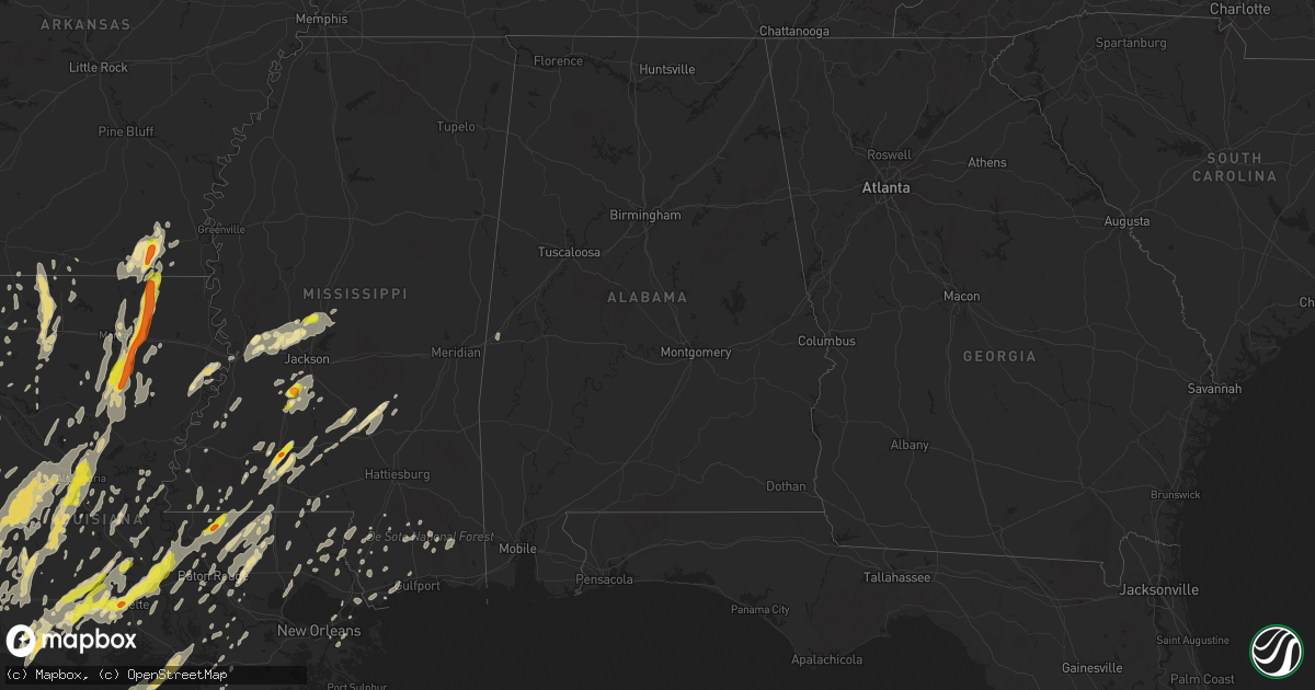
Hail Map in Alabama on April 2, 2017
Get this storm
April 2 map
$229
one time, instant access
Download today. No call, no setup
Keep the $229
Bought the map and want the full workflow? Apply the entire $229 to a subscription within 7 days. None of it is wasted.
Every map, not just this one
This buys you this map. Subscription and you get every map we run, in the markets you choose from a few cities to whole states to nationwide. Plus real-time alerts the moment a storm fires.
Contact data
Name, contact info, occupancy, even credit band for addresses in the footprint. You go from where it hit to who to call.
Become the source they trust
Unlimited branding weather history reports on demand. You already have the documented answer ready for the property owner, and you are the one who showed up with it.
Property data and RoofTrace estimates
Pull up any address you have got, its value and the exact code rules for that jurisdiction, straight from One Click Code. Then RoofTrace estimates the squares, pitch, and roof value, priced the way you price.
Storm reports in Alabama
Alabama
| Date | Description |
|---|---|
| 04/02/20176:45 AM CDT | Trees down on gosport road |
| 04/02/20176:34 AM CDT | Large oak tree fell on a church near the intersection of alabama street and shelby street. Shelby street is impassable. Estimated 45-55 mph winds. Time estimated by rad |
| 04/02/20176:30 AM CDT | 2 large trees down along county road 7 in dallas county blocking the roadway... Reported by wsfa-tv storm tracker. Time estimated by radar. Estimated 40-50 mph winds. |
| 04/02/20176:25 AM CDT | Several trees down |
| 04/02/20176:15 AM CDT | Tree down near the intersection of highway 17 and walker road. |
| 04/02/20176:01 AM CDT | Large tree and power lines down near intersection of faircrest road and ashwood road in hueytown. Estimated 40-50 mph winds. Time estimated by radar. |
| 04/02/20176:01 AM CDT | Tree down near the intersection of 15th street and crest oval mountain road. Time estimated by radar. Estimated 40-50 mph winds. |
| 04/02/20175:56 AM CDT | Power lines downed along center street in bessemer. Time estimated by radar. Estimated 40-50 mph winds. |
| 04/02/20175:56 AM CDT | Trees and power lines down along 15th street between 5th avenue and 6th avenue in bessemer. Time estimated by radar. Estimated 40-50 mph winds. |
| 04/02/20175:56 AM CDT | Large tree fell onto building. Along hueytown road. Time estimated by radar. Estimated 45-55 mph winds. |
| 04/02/20175:55 AM CDT | Trees down on highway 5 |
| 04/02/20175:51 AM CDT | Portion of eastern valley road blocked due to downed trees and power lines. Report relayed via social media. Time estimated by radar. Estimated 40-50 mph winds. |
| 04/02/20175:47 AM CDT | Tree down near the intersection of republic road and cherry avenue. Time estimated by radar. Estimated 40-50 mph winds. |
| 04/02/20175:30 AM CDT | Tree down along county road 10. Estimated 40-50 mph winds. |
| 04/02/20175:30 AM CDT | Tree down along highway 11. Estimated 40-50 mph winds. |
| 04/02/20175:14 AM CDT | Tree down near sumter central high school. Estimated 40-50 mph. |
| 04/02/20175:13 AM CDT | Tree fell onto vehicle in moundville. Report relayed via social media. Time estimated by radar. |
| 04/02/20175:13 AM CDT | Tree down on the campus of the university of alabama. Time estimated by radar. Estimated 40-50 mph winds. Report relayed via social media. |
| 04/02/20175:11 AM CDT | Tree down along u.s. Highway 80. Estimated 40-50 mph winds. |
| 04/02/20175:07 AM CDT | Tree down along county road 9. Estimated 40-50 mph winds. |
| 04/02/20175:00 AM CDT | Trees and power lines down along eastern valley road. Time estimated by radar. Estimated 40-50 mph winds. |
| 04/02/20174:56 AM CDT | Tree fell on vehicle along county road 9. Estimated 40-50 mph winds. |
| 04/02/20174:44 AM CDT | Tree down along highway 11 near cuba. Estimated 40-50 mph winds. |
| 04/02/20174:42 AM CDT | One tree down along highway 28 in sumter county. Estimated 40-50 mph winds. |
| 04/02/20174:25 AM CDT | Trees and power lines down on pine grove road near pennigton |
| 04/02/20174:17 AM CDT | Tree down along townsend mission loop road. Estimated 40-50 mph winds. |
| 04/02/20174:15 AM CDT | Vehicle damaged after running over a tree across highway 11. Estimated 40-50 mph winds. |
| 04/02/20173:52 AM CDT | *** 1 inj *** tree fell onto moving vehicle... One injured. |
| 04/02/20173:50 AM CDT | Trees and power lines down on highway 10 |
| 04/02/20173:50 AM CDT | Trees down on highway 11... Near wallace rd. Additional trees down across the county and widespread power outages confirmed. |
| 04/02/20173:48 AM CDT | Trees and power lines down near the intersection of u.s. Highway 80 and 4th street in cuba. |
All States Impacted by Hail Map on April 2, 2017
Cities Impacted by Hail Map on April 2, 2017
- Belle Rose, LA
- Orange, TX
- Plaquemine, LA
- White Castle, LA
- Sunshine, LA
- Jackson, LA
- Kerrville, TX
- Wiggins, MS
- Perkinston, MS
- Ringgold, LA
- Rio Hondo, TX
- Pennington, TX
- Kennard, TX
- Vinton, LA
- Nacogdoches, TX
- Lufkin, TX
- Spring, TX
- Conroe, TX
- Bossier City, LA
- Corrigan, TX
- Groveton, TX
- New Waverly, TX
- Chappell Hill, TX
- Ganado, TX
- Huntsville, TX
- Jasper, TX
- Bush, LA
- Covington, LA
- Opelousas, LA
- Port Barre, LA
- Picayune, MS
- Carriere, MS
- Morse, LA
- Crowley, LA
- Estherwood, LA
- Gueydan, LA
- Corsicana, TX
- Barry, TX
- Blooming Grove, TX
- Purdon, TX
- Tennessee Colony, TX
- Singer, LA
- Deridder, LA
- Edna, TX
- Bloomington, TX
- Inez, TX
- Madison, MS
- Flora, MS
- Canton, MS
- Dry Prong, LA
- Sabinal, TX
- Glenmora, LA
- Walker, LA
- Hamburg, AR
- Cameron, LA
- Rayville, LA
- Oak Ridge, LA
- Mount Olive, MS
- Franklin, LA
- Collinston, LA
- Smithdale, MS
- Eunice, LA
- Basile, LA
- Mamou, LA
- Byram, MS
- Terry, MS
- Blanco, TX
- Hye, TX
- Slidell, LA
- Diboll, TX
- Garrison, TX
- Chireno, TX
- Timpson, TX
- San Augustine, TX
- Center, TX
- Moscow, TX
- Livingston, TX
- Pollok, TX
- Apple Springs, TX
- Crystal Springs, MS
- Pitkin, LA
- Tallulah, LA
- Long Branch, TX
- Logansport, LA
- Otis, LA
- Lake Charles, LA
- Oakdale, LA
- Olla, LA
- Ragley, LA
- Westlake, LA
- Jones, LA
- Oberlin, LA
- Pollock, LA
- Starks, LA
- Alexandria, LA
- Bonita, LA
- Sterlington, LA
- Tullos, LA
- Reeves, LA
- Iowa, LA
- Columbia, LA
- Monroe, LA
- Elmer, LA
- Longville, LA
- Sulphur, LA
- Kinder, LA
- Bentley, LA
- Colfax, LA
- Woodworth, LA
- Boyce, LA
- Pineville, LA
- Merryville, LA
- Hackberry, LA
- Sieper, LA
- Mittie, LA
- Rosepine, LA
- West Monroe, LA
- Elizabeth, LA
- Deweyville, TX
- Dry Creek, LA
- Ball, LA
- Forest Hill, LA
- Mer Rouge, LA
- Simpson, LA
- Trout, LA
- Fort Polk, LA
- Lena, LA
- Bon Wier, TX
- Lecompte, LA
- Leesville, LA
- Call, TX
- Bastrop, LA
- Grant, LA
- Sugartown, LA
- Mora, LA
- Kelly, LA
- Jena, LA
- Dequincy, LA
- Hineston, LA
- Grayson, LA
- Flatwoods, LA
- Lottie, LA
- Fordoche, LA
- Shepherd, TX
- Church Point, LA
- Pocatello, ID
- Rayne, LA
- Duson, LA
- Grand Chenier, LA
- Lake Arthur, LA
- Creole, LA
- Kenansville, FL
- Frostproof, FL
- Wiergate, TX
- Hemphill, TX
- Florien, LA
- Anacoco, LA
- Goldonna, LA
- Leona, TX
- Centerville, TX
- Leander, TX
- Liberty Hill, TX
- Denham Springs, LA
- Midway, TX
- Lovelady, TX
- Crockett, TX
- Grapeland, TX
- Streetman, TX
- Fairfield, TX
- Buffalo, TX
- Kerens, TX
- Oakwood, TX
- Athens, LA
- Brookhaven, MS
- Kendalia, TX
- Boerne, TX
- Silsbee, TX
- Centreville, MS
- Woodville, MS
- Spicewood, TX
- Mize, MS
- Lolita, TX
- Tatum, TX
- Vidor, TX
- Nederland, TX
- Lisbon, LA
- Simsboro, LA
- Haynesville, LA
- Dubach, LA
- Ruston, LA
- Quitman, LA
- Bienville, LA
- Bernice, LA
- Arcadia, LA
- Grambling, LA
- Homer, LA
- Junction City, AR
- Summerfield, LA
- Bentonia, MS
- Clinton, MS
- Bolton, MS
- Vicksburg, MS
- Jackson, MS
- Edwards, MS
- Armstrong, TX
- Trinity, TX
- Frierson, LA
- Alto, TX
- Theriot, LA
- Slaughter, LA
- Pride, LA
- Newellton, LA
- La Pryor, TX
- Crystal City, TX
- Dilley, TX
- Batesville, TX
- Rusk, TX
- Shreveport, LA
- Florence, MS
- Franklin, TX
- Cotulla, TX
- Poplarville, MS
- Harlingen, TX
- Fredericksburg, TX
- Comfort, TX
- Carthage, TX
- Beckville, TX
- Montrose, AR
- Portland, AR
- Trinidad, TX
- Kentwood, LA
- Pearsall, TX
- Jonesville, LA
- Monterey, LA
- Greenwell Springs, LA
- Amite, LA
- Greensburg, LA
- Osyka, MS
- Zachary, LA
- Clinton, LA
- Liberty, MS
- Woodville, TX
- Hillister, TX
- Spurger, TX
- Morgan City, LA
- Evans, LA
- Burkeville, TX
- Meadville, MS
- Berwick, LA
- Dripping Springs, TX
- Round Top, TX
- Fayetteville, TX
- Bandera, TX
- Ingram, TX
- Hunt, TX
- Center Point, TX
- Medina, TX
- Gibson, LA
- Grand Cane, LA
- Stonewall, LA
- Mansfield, LA
- Ruth, MS
- Bogue Chitto, MS
- Summit, MS
- Magee, MS
- Raymondville, TX
- San Perlita, TX
- Crossett, AR
- Monticello, MS
- Zavalla, TX
- Huntington, TX
- Fayette, MS
- Robeline, LA
- New Braunfels, TX
- Braithwaite, LA
- Saint Bernard, LA
- Violet, LA
- Baton Rouge, LA
- Gibsland, LA
- Dubberly, LA
- Livingston, LA
- Holden, LA
- Taylorsville, MS
- Stringer, MS
- Mexia, TX
- Coushatta, LA
- Ville Platte, LA
- Lorman, MS
- Victoria, TX
- Collins, MS
- Prentiss, MS
- Tylertown, MS
- Cleveland, TX
- Vancleave, MS
- Marksville, LA
- Acme, LA
- Napoleonville, LA
- Port Mansfield, TX
- Ennis, TX
- Sontag, MS
- Maringouin, LA
- Rosedale, LA
- Grosse Tete, LA
- New Orleans, LA
- Roseland, LA
- Richland, TX
- Wortham, TX
- De Berry, TX
- Winnfield, LA
- Georgetown, LA
- San Benito, TX
- La Grange, TX
- Muldoon, TX
- Moody, TX
- Kosse, TX
- Thornton, TX
- Fred, TX
- Many, LA
- Normangee, TX
- Madisonville, TX
- Jewett, TX
- D Hanis, TX
- York, AL
- Los Fresnos, TX
- Combes, TX
- La Feria, TX
- Lafayette, LA
- Arnaudville, LA
- Breaux Bridge, LA
- Scott, LA
- Welsh, LA
- Cheneyville, LA
- Newton, TX
- Kountze, TX
- Folsom, LA
- Buna, TX
- Kirbyville, TX
- Carencro, LA
- Marthaville, LA
- Minden, LA
- New Iberia, LA
- Mccomb, MS
- Jayess, MS
- Pleasant Hill, LA
- Belmont, LA
- Zwolle, LA
- Bergheim, TX
- Mermentau, LA
- Lacassine, LA
- Evangeline, LA
- Egan, LA
- Jennings, LA
- Krotz Springs, LA
- Livonia, LA
- Broussard, LA
- Kaplan, LA
- Branch, LA
- Saint Martinville, LA
- Iota, LA
- Morganza, LA
- Maurice, LA
- Utica, MS
- Bremond, TX
- Groesbeck, TX
- Teague, TX
- Bedias, TX
- Richards, TX
- San Marcos, TX
- Noble, LA
- Wells, TX
- Moreauville, LA
- Bogalusa, LA
- Saint Gabriel, LA
- Camden, MS
- Newhebron, MS
- Pinola, MS
- Silver Creek, MS
- Mendenhall, MS
- Colmesneil, TX
- Chester, TX
- Pearlington, MS
- Bay Saint Louis, MS
- El Campo, TX
- Markham, TX
- Hondo, TX
- Ponchatoula, LA
- Port Allen, LA
- Brusly, LA
- Addis, LA
- Shelbyville, TX
- Hornbeck, LA
- Parkdale, AR
- Wilmot, AR
- Gonzales, LA
- Prairieville, LA
- Mount Enterprise, TX
- Broaddus, TX
- Effie, LA
- Willis, TX
- Elm Grove, LA
- Harrisville, MS
- Lumberton, MS
- Driftwood, TX
- Austin, TX
- Kyle, TX
- Wimberley, TX
- Buda, TX
- Bronson, TX
- Port Sulphur, LA
- Saucier, MS
- Spearsville, LA
- Hillsboro, TX
- Saint Joseph, LA
- Pierre Part, LA
- Waveland, MS
- Pass Christian, MS
- Cottonport, LA
- Bunkie, LA
- Evergreen, LA
- Louise, TX
- Montgomery, TX
- Fowlerton, TX
- Ethel, LA
- Loranger, LA
- Husser, LA
- Tenaha, TX
- Gary, TX
- Joaquin, TX
- Plaucheville, LA
- Palmetto, LA
- Lettsworth, LA
- Batchelor, LA
- Washington, LA
- Franklinton, LA
- Mount Hermon, LA
- Jeanerette, LA
- Gloster, MS
- El Dorado, AR
- Strong, AR
- Greenwood, LA
- Bethany, LA
- Roxie, MS
- Lyford, TX
- Lockhart, TX
- Seguin, TX
- Martindale, TX
- Kingsbury, TX
- Luling, TX
- Cloutierville, LA
- Atlanta, LA
- Montgomery, LA
- Saint James, LA
- Saint Amant, LA
- Saline, LA
- Carville, LA
- Sikes, LA
- Magnolia, TX
- Marble Falls, TX
- Plain Dealing, LA
- Del Valle, TX
- Canyon Lake, TX
- San Antonio, TX
- Schertz, TX
- Pointblank, TX
- Onalaska, TX
- McCall Creek, MS
- Emerson, AR
- Dawson, TX
- Youngsville, LA
- Hermanville, MS
- Port Gibson, MS
- Lillie, LA
- Wilson, LA
- Hazlehurst, MS
- Plantersville, TX
- Johnson City, TX
- Mansura, LA
- French Settlement, LA
- Mangham, LA
- Fort Necessity, LA
- Winnsboro, LA
- Hearne, TX
- Wisner, LA
- Pleasanton, TX
- Coldspring, TX
- Braxton, MS
- Athens, TX
- Eustace, TX
- Keithville, LA
- Jarreau, LA
- Saint Francisville, LA
- Norwood, LA
- Sunset, LA
- New Roads, LA
- Ventress, LA
- Abbeville, LA
- Oscar, LA
- Carmine, TX
- Ledbetter, TX
- Liberty, TX
- Thibodaux, LA
- Labadieville, LA
- Round Mountain, TX
- Kiln, MS
- West, TX
- Waco, TX
- Goodrich, TX
- Mercedes, TX
- Santa Rosa, TX
- Bay Springs, MS
- Pipe Creek, TX
- Aberdeen, ID
- Anderson, TX
- Navasota, TX
- Lacombe, LA
- Gulfport, MS
- Robert, LA
- Etoile, TX
- Chatham, LA
- Jamestown, LA
- Enterprise, LA
- Baker, LA
- Fluker, LA
- Pine Grove, LA
- Magnolia, MS
- Independence, LA
- Georgetown, MS
- Fisher, LA
- Converse, LA
- Abbott, TX
- Bynum, TX
- Spring Branch, TX
- Brookeland, TX
- Ashland, LA
- Bulverde, TX
- Waskom, TX
- Hempstead, TX
- Huttig, AR
- Monticello, AR
- Saratoga, TX
- Edcouch, TX
- Cibolo, TX
- Simmesport, LA
- Dermott, AR
- Gloster, LA
- Natchez, MS
- Waller, TX
- Kemp, TX
- Mabank, TX
- Granger, TX
- Georgetown, TX
- Rice, TX


