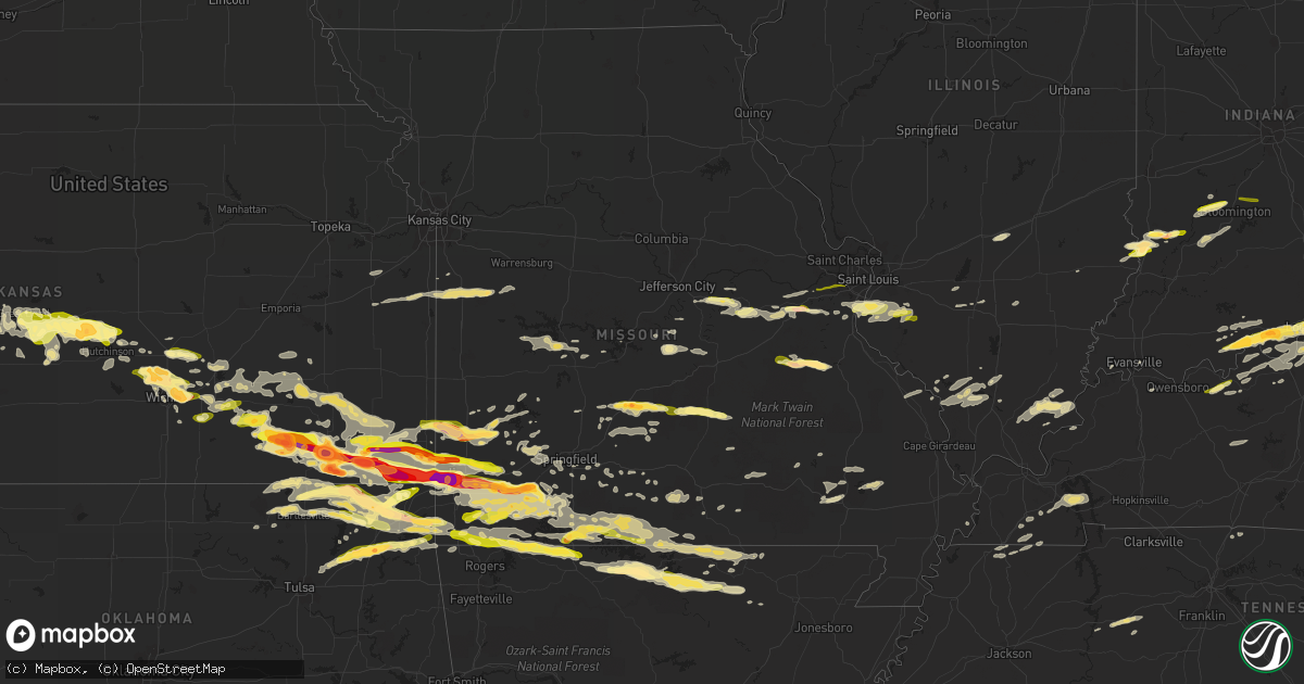
Hail Map in Missouri on April 2, 2015
Get this storm
April 2 map
$229
one time, instant access
Download today. No call, no setup
Keep the $229
Bought the map and want the full workflow? Apply the entire $229 to a subscription within 7 days. None of it is wasted.
Every map, not just this one
This buys you this map. Subscription and you get every map we run, in the markets you choose from a few cities to whole states to nationwide. Plus real-time alerts the moment a storm fires.
Contact data
Name, contact info, occupancy, even credit band for addresses in the footprint. You go from where it hit to who to call.
Become the source they trust
Unlimited branding weather history reports on demand. You already have the documented answer ready for the property owner, and you are the one who showed up with it.
Property data and RoofTrace estimates
Pull up any address you have got, its value and the exact code rules for that jurisdiction, straight from One Click Code. Then RoofTrace estimates the squares, pitch, and roof value, priced the way you price.
Storm reports in Missouri
Missouri
| Date | Description |
|---|---|
| 04/02/20154:12 PM CDT | A local report indicates 1.00 inch wind near 3 NW VALLEY PARK |
| 04/02/20153:54 PM CDT | Public reported quarter sized hail. |
| 04/02/20153:52 PM CDT | A local report indicates 1.00 inch wind near LEBANON |
| 04/02/20153:50 PM CDT | Reported by dept of conservation relayed by ema. |
| 04/02/20153:42 PM CDT | A local report indicates 1.00 inch wind near 4 S AUGUSTA |
| 04/02/20159:33 AM CDT | Quarter to half dollar size hail |
| 04/02/20154:38 AM CDT | Power lines down 6th street and college in downtown branson as well as electric utility reporting outages |
| 04/02/20153:55 AM CDT | A local report indicates 1.25 inch wind near CRANE |
| 04/02/20153:45 AM CDT | Facebook picture |
| 04/02/20153:38 AM CDT | A local report indicates 1.00 inch wind near 1 NW VERONA |
| 04/02/20153:32 AM CDT | Numerous broken glass reports across southern lawrence and northern barry counties |
| 04/02/20153:31 AM CDT | In city limits of monett |
| 04/02/20153:25 AM CDT | A local report indicates 1.00 inch wind near PIERCE CITY |
| 04/02/20152:55 AM CDT | Numerous quarter size hail reports in joplin |
| 04/02/20152:30 AM CDT | Damage to grain bins...aluminum sided carport...some fencing and a few trees. All on remote farm located just inside dunklin county line from stoddard county. Actual ad |
| 04/02/20151:26 AM CDT | Several trees down across highway 99. Time estimated. |
| 04/02/201512:57 AM CDT | Power lines were reported down in pomona. Time estimated by radar. |
| 04/02/201512:52 AM CDT | Rating: ef-2 estimated peak wind: 120 mph path length /statute/: 7.6 miles path width /maximum/: 440 yards fatalities: 0 injuries: 0 start date: apr 03 2015 start time: |
| 04/02/201512:51 AM CDT | House heavily damaged... Trees and power lines down. |
| 04/02/201512:32 AM CDT | Numerous trees down on highway 95 and route w. |
| 04/02/201512:26 AM CDT | A tornado rated ef-1 tracked from 0.4 mi south southwest of vanzant for approximately 3 minutes before lifting 0.9 mi southeast of vanzant. Several outbuildings were de |
| 04/02/201512:18 AM CDT | Trees down. |
| 04/01/201511:30 PM CDT | Trees uprooted and damage to a barn. Highway kk 2.2 miles north of arkansas border. |
| 04/01/201511:30 PM CDT | Trees uprooted and damage to a barn. Highway kk 2.2 miles north of arkansas border. |
| 04/01/201511:25 PM CDT | Rating: ef-1 estimated peak wind: 100 mph path length /statute/: 12.6 miles path width /maximum/: 100 yards fatalities: 0 injuries: start date: apr 02 2015 start time: |
| 04/01/201511:12 PM CDT | Near mile marker 239 on i-44. Mostly pea size hail with a few hail stones up to an inch in diameter. |
| 04/01/201511:04 PM CDT | A local report indicates 1.50 inch wind near 5 N URICH |
| 04/01/201510:49 PM CDT | A few quarter sized hail stones with lots of dime sized stones |
| 04/01/201510:45 PM CDT | Several large tree limbs blown down. |
| 04/01/201510:42 PM CDT | A local report indicates 1.00 inch wind near 1 NE GARDEN CITY |
| 04/01/201510:40 PM CDT | A local report indicates 1.25 inch wind near ARCHIE |
| 04/01/201510:40 PM CDT | Near nn and dutch creek in the cedar hill dittmer area. |
| 04/01/201510:29 PM CDT | A dozen 1 1/2 inch impacts on hail pad. |
| 04/01/201510:26 PM CDT | Public reported quarter sized hail 6 miles e of south west city. Time estimated by radar. |
| 04/01/201510:12 PM CDT | A local report indicates 1.00 inch wind near UNION |
| 04/01/201510:05 PM CDT | Nickel to quarter-sized hail. |
| 04/01/20159:55 PM CDT | A local report indicates 1.00 inch wind near 2 S UNION |
| 04/01/20159:10 PM CDT | An ef-0 tornado with winds estimated around 80 mph caused damage to a single family home...along with several trees and outbuildings on the property. |
| 04/01/20159:08 PM CDT | Tree down at 4th and ivy in oronogo |
| 04/01/20158:58 PM CDT | A local report indicates 1.50 inch wind near GOLDEN CITY |
| 04/01/20158:44 PM CDT | A local report indicates 1.50 inch wind near CARL JUNCTION |
| 04/01/20158:33 PM CDT | A local report indicates a tornado near 5 WSW GOLDEN CITY |
| 04/01/20158:33 PM CDT | Rating: ef-0 estimated peak wind: 85 mph path length /statute/: 2.6 miles path width /maximum/: 100 yards fatalities: 0 injuries: 0 start date: apr 02 2015 start time: |
| 04/01/20158:25 PM CDT | At stockton dam |
| 04/01/20158:25 PM CDT | Trees down at i49 and hwy 126. Possible tornado. |
| 04/01/20158:20 PM CDT | A local report indicates a tornado near 2 NW JASPER |
| 04/01/20157:34 PM CDT | A local report indicates 1.50 inch wind near 2 SE MINERAL POINT |
| 04/01/20157:30 PM CDT | Hail size varied from quarter to half dollar. |
| 04/01/20157:24 PM CDT | A local report indicates 1.75 inch wind near 2 S OLD MINES |
| 04/01/20157:17 PM CDT | A local report indicates 1.00 inch wind near 7 W POTOSI |
All States Impacted by Hail Map on April 2, 2015
Cities Impacted by Hail Map on April 2, 2015
- Partridge, KS
- Nickerson, KS
- Abbyville, KS
- Pawhuska, OK
- Peru, KS
- Niotaze, KS
- Rosebud, MO
- Owensville, MO
- Licking, MO
- Miami, OK
- Bradleyville, MO
- Branson, MO
- Ridgedale, MO
- Squires, MO
- Gainesville, MO
- Cedarcreek, MO
- Pontiac, MO
- Powersite, MO
- Hollister, MO
- Forsyth, MO
- Ava, MO
- Kirbyville, MO
- Isabella, MO
- Kissee Mills, MO
- Theodosia, MO
- Rueter, MO
- Thornfield, MO
- Noble, MO
- Salem, AR
- Muldraugh, KY
- Louisville, KY
- Laconia, IN
- Webster, KY
- Brandenburg, KY
- Shepherdsville, KY
- Fort Knox, KY
- Fairdale, KY
- West Point, KY
- Fisherville, KY
- Brooks, KY
- Irvington, KY
- Hardinsburg, KY
- Taylorsville, KY
- Ekron, KY
- Vine Grove, KY
- Guston, KY
- Corydon, IN
- Elizabeth, IN
- Galesburg, KS
- Erie, KS
- Walnut Hill, IL
- Centralia, IL
- Saint Louis, MO
- Millstadt, IL
- Waterloo, IL
- Columbia, IL
- Valmeyer, IL
- Arnold, MO
- Lenapah, OK
- S Coffeyville, OK
- Eureka Springs, AR
- Ness City, KS
- Labadie, MO
- Flippin, AR
- Longton, KS
- Elk Falls, KS
- Chamois, MO
- Linn, MO
- Walnut Ridge, AR
- Golden City, MO
- Lockwood, MO
- Lamar, MO
- Falcon, MO
- Laquey, MO
- Lebanon, MO
- Phillipsburg, MO
- Jeffersonville, IN
- Saint Elmo, IL
- Brownstown, IL
- Mayfield, KY
- Wingo, KY
- Perry, FL
- Chelsea, OK
- Ottawa, KS
- Wellsville, KS
- Seymour, MO
- Oldfield, MO
- Bruner, MO
- Sparta, MO
- Wheatland, MO
- Cross Timbers, MO
- Yellville, AR
- Stockton, MO
- Dickson, TN
- Nunnelly, TN
- Hurricane Mills, TN
- Only, TN
- McEwen, TN
- Lobelville, TN
- Bon Aqua, TN
- Parsons, KS
- Iberia, MO
- Gerald, MO
- Colby, KS
- Brookline, MO
- Springfield, MO
- Chanute, KS
- Thayer, KS
- Mount Vernon, IN
- Dixon, MO
- Thomaston, GA
- Sedan, KS
- Elk City, KS
- Howard, KS
- Moline, KS
- Hutchinson, KS
- Buhler, KS
- Mount Sterling, MO
- Bland, MO
- Beulah, MO
- Sedgwick, KS
- Bentley, KS
- Independence, KS
- Hardy, AR
- Ava, IL
- Great Bend, KS
- St John, KS
- Pawnee Rock, KS
- Birmingham, AL
- Oswego, KS
- Coffeyville, KS
- Chetopa, KS
- McCune, KS
- Joplin, MO
- Fredonia, KS
- Columbus, KS
- Bartlett, KS
- Baxter Springs, KS
- Cherokee, KS
- Neosho, MO
- Webb City, MO
- Scammon, KS
- Pittsburg, KS
- Oronogo, MO
- Edna, KS
- West Mineral, KS
- Cherryvale, KS
- Diamond, MO
- Altamont, KS
- Weir, KS
- Liberty, KS
- Galena, KS
- Mound Valley, KS
- Riverton, KS
- Carl Junction, MO
- El Dorado, KS
- Rosalia, KS
- Vinita, OK
- Bluejacket, OK
- Oaktown, IN
- Whitewater, KS
- Valley Center, KS
- Newton, KS
- Augusta, KS
- South Fulton, TN
- Equality, IL
- Bushnell, FL
- La Grange, KY
- Smithfield, KY
- Crestwood, KY
- Portland, TN
- English, IN
- New Albany, IN
- Saint Croix, IN
- Bristow, IN
- Birdseye, IN
- Lyons, KS
- Alden, KS
- Raymond, KS
- Sterling, KS
- Ellinwood, KS
- Ethel, MS
- Delaware, OK
- Nowata, OK
- Big Cabin, OK
- Adair, OK
- Poplar Bluff, MO
- Edwards, MO
- Quincy, MO
- Warsaw, MO
- Lowry City, MO
- Osceola, MO
- Jasper, MO
- Marshfield, MO
- Salem, MO
- Evansville, IN
- Wakeeney, KS
- Wichita, KS
- Kechi, KS
- Dighton, KS
- Quinter, KS
- Virgil, KS
- Flat Rock, IL
- Carlisle, IN
- Edwardsport, IN
- Palestine, IL
- Carlyle, IL
- Grenola, KS
- Piedmont, KS
- Latham, KS
- West, MS
- Kosciusko, MS
- Golden, MO
- Powell, MO
- Omaha, AR
- Oak Grove, AR
- Pineville, MO
- Eagle Rock, MO
- Shell Knob, MO
- Washburn, MO
- Garfield, AR
- Green Forest, AR
- Berryville, AR
- Seligman, MO
- Sulphur Springs, AR
- Gravette, AR
- Kinsley, KS
- Jay, OK
- Copan, OK
- Hudson, KS
- Welch, OK
- Dewey, OK
- Afton, OK
- Wann, OK
- Granby, MO
- Stark City, MO
- Monett, MO
- Purdy, MO
- Pierce City, MO
- Crocker, MO
- Smithville, AR
- Poughkeepsie, AR
- Frohna, MO
- Dunnegan, MO
- Fair Play, MO
- Aurora, MO
- Cassville, MO
- Mineral Point, MO
- Potosi, MO
- Bonne Terre, MO
- Cadet, MO
- Mill Spring, MO
- Williamsville, MO
- Lane, KS
- Osawatomie, KS
- Scott City, KS
- Carbondale, IL
- Strawberry, AR
- Benton, KY
- Tuscumbia, MO
- Genoa, CO
- Limon, CO
- Carthage, MO
- Murphysboro, IL
- Herrin, IL
- Grand Tower, IL
- De Soto, IL
- Carterville, IL
- Marion, IL
- Makanda, IL
- Cambria, IL
- Pomona, IL
- Leon, KS
- Larned, KS
- Union City, TN
- Martin, TN
- Hume, MO
- Fort Scott, KS
- Towanda, KS
- Benton, KS
- Potwin, KS
- Flagler, CO
- Climax, GA
- Eureka, KS
- Utica, KS
- Claremore, OK
- Pryor, OK
- Kit Carson, CO
- Linton, IN
- Reeds Spring, MO
- Bloomfield, IN
- Owensburg, IN
- Stafford, KS
- Sylvia, KS
- Bloomfield, KY
- Wentworth, MO
- Burns, KS
- Little River, KS
- Chase, KS
- Inman, KS
- Haven, KS
- Fall River, KS
- Toronto, KS
- Grandin, MO
- Ellsinore, MO
- Cannelton, IN
- Battletown, KY
- Leavenworth, IN
- Cassoday, KS
- Exeter, MO
- Rogersville, MO
- Andover, KS
- Protem, MO
- Sarcoxie, MO
- Marionville, MO
- Verona, MO
- Crane, MO
- Galena, MO
- Beeler, KS
- Norfork, AR
- Calico Rock, AR
- Violet Hill, AR
- Dolph, AR
- Wideman, AR
- Mountain Home, AR
- Pineville, AR
- Oxford, AR
- Brockwell, AR
- Maize, KS
- Shelbyville, KY
- Pewee Valley, KY
- Burdett, KS
- Rozel, KS
- Hoxie, KS
- Cave In Rock, IL
- Harrisburg, IL
- Eddyville, IL
- Stonefort, IL
- Elizabethtown, IL
- Herod, IL
- Junction, IL
- Carrier Mills, IL
- Shawneetown, IL
- Eucha, OK
- Yates Center, KS
- Catawissa, MO
- Robertsville, MO
- Villa Ridge, MO
- Union, MO
- Saint Clair, MO
- Creighton, MO
- Harrisonville, MO
- Drexel, MO
- Garden City, MO
- Archie, MO
- Bois D Arc, MO
- Miller, MO
- Everton, MO
- Ash Grove, MO
- Willard, MO
- Bakersfield, MO
- Henderson, AR
- Gepp, AR
- Camp, AR
- Sturkie, AR
- Gamaliel, AR
- Viola, AR
- Mammoth Spring, AR
- Clarkridge, AR
- Hanston, KS
- Greenfield, MO
- Niangua, MO
- Grovespring, MO
- Durant, MS
- Sallis, MS
- Derby, KS
- Mount Washington, KY
- Walnut Shade, MO
- Cloverport, KY
- Hawesville, KY
- Reynolds Station, KY
- Plato, MO
- Duke, MO
- Central, IN
- Mauckport, IN
- Benedict, KS
- Caney, KS
- Mcconnell Afb, KS
- Aldrich, MO
- Smithton, IL
- New Athens, IL
- Freeburg, IL
- South West City, MO
- Rush Center, KS
- Vanzant, MO
- Dora, MO
- Glenview, KY
- Clarksville, IN
- Masonic Home, KY
- Mascoutah, IL
- Hermann, MO
- Morrison, MO
- Elbing, KS
- Morgantown, KY
- Butterfield, MO
- Colwich, KS
- Asbury, MO
- Neodesha, KS
- Rocky Comfort, MO
- Wheaton, MO
- Quapaw, OK
- Spokane, MO
- Reeds, MO
- Cape Fair, MO
- Carterville, MO
- Girard, KS
- Fairview, MO
- Dennis, KS
- Billings, MO
- Stella, MO
- Ponce De Leon, MO
- Grove, OK
- Mayo, FL
- Ash Flat, AR
- Evening Shade, AR
- Horseshoe Bend, AR
- Bartlesville, OK
- West Plains, MO
- Willow Springs, MO
- Harrison, AR
- Gassville, AR
- Franklin, AR
- Cotter, AR
- Lakeview, AR
- Ellington, MO
- Richmond, KS
- Macomb, MO
- Saint Paul, KS
- Buffalo, KS
- Mount Hope, KS
- Greenwich, KS
- Burrton, KS
- Highlandville, MO
- Imperial, MO
- Norwood, MO
- Piedmont, MO
- Havana, KS
- Buffalo, MO
- Half Way, MO
- High Ridge, MO
- Fenton, MO
- Belleville, IL
- Lenzburg, IL
- Douglass, KS
- Stotts City, MO
- Oakley, KS
- Strang, OK
- Collinsville, OK
- Owasso, OK
- Cherokee Village, AR
- Louisburg, KS
- Fontana, KS
- Rantoul, KS
- Paola, KS
- Urich, MO
- Blairstown, MO
- Frontenac, KS
- Liberal, MO
- Mindenmines, MO
- Bull Shoals, AR
- Washington, MO
- Lyons, IN
- Forsyth, GA
- Leslie, MO
- Beaufort, MO
- Sullivan, MO
- Hartshorn, MO
- Eminence, MO
- Adrian, MO
- Wyandotte, OK
- Seneca, MO
- Tiff City, MO
- Bella Vista, AR
- Fairland, OK
- Noel, MO
- Anderson, MO
- North Miami, OK
- Goodman, MO
- Commerce, OK
- Lanagan, MO
- Lampe, MO
- Pea Ridge, AR
- Long Lane, MO
- Fordland, MO
- Moody, MO
- Caulfield, MO
- Lexington, MS
- Chestnutridge, MO
- Duenweg, MO
- Cambridge, KS
- La Russell, MO
- Mansfield, MO
- Otis, KS
- Albert, KS
- Hartville, MO
- Branchville, IN
- Tell City, IN
- Lanesville, IN
- New Middletown, IN
- Georgetown, IN
- Sulphur, IN
- Leopold, IN
- Harned, KY
- Garfield, KS
- Wappapello, MO
- McGee, MO
- Puxico, MO
- Solsberry, IN
- Bloomington, IN
- Freedom, IN
- Worthington, IN
- Ellettsville, IN
- Gosport, IN
- Spencer, IN
- Conway, MO
- Saint Elizabeth, MO
- Meta, MO
- Severy, KS
- Drury, MO
- Halltown, MO
- Republic, MO
- Cedar Hill, MO
- Jerico Springs, MO
- Caneyville, KY
- East Prairie, MO
- Collyer, KS
- Sandborn, IN
- Jetmore, KS
- Fulton, KY
- Sedalia, KY
- Yatesville, GA
- Barnesville, GA
- Derby, IN
- Prospect, KY
- Finchville, KY
- Bagdad, KY
- Depauw, IN
- Marengo, IN
- Grantsburg, IN
- Milltown, IN
- Henderson, KY
- Mount Vernon, MO
- Perryville, MO
- Pell City, AL
- Mulvane, KS
- Crane, IN
- Springville, IN
- Selden, KS
- Taneyville, MO
- Mountain Grove, MO
- Barnhart, MO
- South Greenfield, MO
- Kirksey, KY
- Cadiz, KY
- Kuttawa, KY
- Gilbertsville, KY
- Owenton, KY
- Sadieville, KY
- Corinth, KY
- Stamping Ground, KY
- Hugo, CO
- Dadeville, MO
- Chilhowee, MO
- Lead Hill, AR
- Wiseman, AR
- Elizabeth, AR
- Jacob, IL
- Clever, MO
- Walnut Grove, MO
- Leeds, AL
- Rockaway Beach, MO
- Pomona, MO
- Coxs Creek, KY
- Greenville, FL
- Osage Beach, MO
- Johnston City, IL
- West Frankfort, IL
- Saint Thomas, MO
- Sterrett, AL
- Chelsea, AL
- House Springs, MO
- Richview, IL
- Healy, KS
- Nekoma, KS
- Alexander, KS
- Cleveland, MO
- Frankfort, KY
- Peace Valley, MO
- Walton, KS
- Birch Tree, MO
- Altoona, KS
- Rosiclare, IL
- Golconda, IL
- Roach, MO
- Hoyleton, IL
- Nashville, IL
- Olney, IL
- Hamilton, KS
- Greenville, MO
- Burlington, CO
- Belle, MO
- Westphalia, MO
- Loose Creek, MO
- Simpsonville, KY
- Farmington, KY
- Hazel, KY
- Atlanta, KS
- Neal, KS
- Blue Eye, MO
- Walnut, KS
- Wasola, MO
- Hardenville, MO
- Kimberling City, MO
- Udall, MO
- Tecumseh, MO
- Arcola, MO
- Rexford, KS
- Marion, KY
- Lawrenceville, IL
- Sullivan, IN
- Dugger, IN
- Rolla, MO
- Newburg, MO
- Vienna, MO
- Picher, OK
- Lynchburg, MO
- Halstead, KS
- Cheyenne Wells, CO
- Falmouth, KY
- Williamstown, KY
- Simpson, IL
- Ozark, IL
- Royalton, IL
- Mulkeytown, IL
- Ridgway, IL
- Palmersville, TN
- Dukedom, TN
- Elkland, MO
- Falls Of Rough, KY
- Williford, AR
- Ravenden, AR
- Vandiver, AL
- Keenes, IL
- Bluford, IL
- Bourbon, MO
- Union Star, KY
- Payneville, KY
- Rhodelia, KY
- Madison, KS
- Sumterville, FL
- Centerville, TN
- Nixa, MO
- Ozark, MO
- Winona, MO
- Peculiar, MO
- Lebanon Junction, KY
- Arriba, CO
- Ballwin, MO
- Wildwood, MO
- Pacific, MO
- Steelville, MO
- Philpot, KY
- Switz City, IN
- Unionville, IN
- Nashville, IN
- Mulberry, KS
- Franklin, KS
- Edgar Springs, MO


