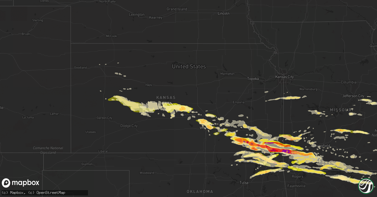
Hail Map in Kansas on April 2, 2015
Get this storm
April 2 map
$229
one time, instant access
Download today. No call, no setup
Keep the $229
Bought the map and want the full workflow? Apply the entire $229 to a subscription within 7 days. None of it is wasted.
Every map, not just this one
This buys you this map. Subscription and you get every map we run, in the markets you choose from a few cities to whole states to nationwide. Plus real-time alerts the moment a storm fires.
Contact data
Name, contact info, occupancy, even credit band for addresses in the footprint. You go from where it hit to who to call.
Become the source they trust
Unlimited branding weather history reports on demand. You already have the documented answer ready for the property owner, and you are the one who showed up with it.
Property data and RoofTrace estimates
Pull up any address you have got, its value and the exact code rules for that jurisdiction, straight from One Click Code. Then RoofTrace estimates the squares, pitch, and roof value, priced the way you price.
Storm reports in Kansas
Kansas
| Date | Description |
|---|---|
| 04/02/201511:30 AM CDT | Several power poles snapped 3 miles east of nickerson. |
| 04/02/20152:45 AM CDT | Hail size ranged from nickles to quarters. |
| 04/02/20152:19 AM CDT | A local report indicates 1.75 inch wind near CHETOPA |
| 04/02/20152:09 AM CDT | A local report indicates 1.00 inch wind near ALTAMONT |
| 04/02/20152:08 AM CDT | A local report indicates 2.75 inch wind near ALTAMONT |
| 04/02/20151:58 AM CDT | Law enforcement reports golf ball sized hail with tree and window damage. |
| 04/02/20151:54 AM CDT | Viewer of fox 23 in tulsa sent a picture of three inch hail near coffeyville. |
| 04/02/20151:46 AM CDT | Viewer of fox23 tulsa sends a pic of grapefruit size hail. Time is based off radar. |
| 04/02/20151:45 AM CDT | A local report indicates 1.50 inch wind near INDEPENDENCE |
| 04/02/20151:44 AM CDT | A local report indicates 1.25 inch wind near 4 SW INDEPENDENCE |
| 04/02/20151:30 AM CDT | 1/2 of barn roof blown off with 8 inch tree limbs down |
| 04/02/20151:30 AM CDT | Trained spotter states winds are stronger than 80 mph and closer to 90 mph at us 160. |
| 04/02/20151:28 AM CDT | A local report indicates 2.50 inch wind near 7 WNW HALE |
| 04/02/20151:15 AM CDT | A local report indicates 1.50 inch wind near 5 W HOWARD |
| 04/02/20151:14 AM CDT | A local report indicates 1.75 inch wind near MOLINE |
| 04/02/20151:07 AM CDT | Emergency manager reports damage to buildings in moline which includes windows blown out. There is possibly mobile home damage as well. Time is based on radar. |
| 04/02/201512:45 AM CDT | Reports of power poles down 9 miles west of atlanta. |
| 04/02/201512:45 AM CDT | Cooperative observer in burns measured 65 mph wind gust. Time estimated. |
| 04/02/201512:45 AM CDT | Mobile home destroyed with 2 injuries 3 miles east and 2.5 miles south of el dorado. |
| 04/02/201512:41 AM CDT | A local report indicates 65 MPH wind near 1 E AUGUSTA |
| 04/02/201512:35 AM CDT | Report via kake. |
| 04/02/201512:35 AM CDT | Emergency manager reports two mobile homes in douglass have been destroyed. Time is estimated from radar. |
| 04/02/201512:32 AM CDT | A local report indicates 1.00 inch wind near ANDOVER |
| 04/02/201512:32 AM CDT | Spotter estimated 70 mph winds which blew a transformer and resulted in power outage in north rose hill. |
| 04/02/201512:31 AM CDT | Estimated 75 mph winds along with power outages. |
| 04/02/201512:30 AM CDT | Dime size was also covering the ground. |
| 04/02/201512:30 AM CDT | 89 mph winds measured at the kansas aviation museum. Report via kake. |
| 04/02/201512:28 AM CDT | A local report indicates 74 MPH wind near MCCONNELL AFB |
| 04/02/201512:28 AM CDT | Ksn employee estiamtes quarter to golfball hail at central and greenwich. |
| 04/02/201512:26 AM CDT | Public sends picture via twitter of window damage and a window frame being tore out as well as blown out car windows in derby. |
| 04/02/201512:26 AM CDT | A local report indicates 1.00 inch wind near 3 E EAST WICHITA |
| 04/02/201512:24 AM CDT | 60 mph winds along with nickel size hail. |
| 04/02/201512:22 AM CDT | Straight line wind damage from a channelled microburst. Began near kansas heart hospital with some debris from their roof which is located across from jabara airport. 1 |
| 04/02/201512:22 AM CDT | *** 1 inj *** one person was blown off their porch at lakeside mobile home park. Extent of injuries are unknown at this time. Time is estimated. |
| 04/02/201512:20 AM CDT | A wall was damaged on a house and a mobile home was destroyed 4 miles west of whitewater. 2 semis were blown over on interstate 135 in the newton vicinity. Time estimat |
| 04/02/201512:20 AM CDT | *** 2 inj *** the 2 minor injuries occurred when roof blew off ems building at hillside and k-96. Time was estimated. |
| 04/02/201512:18 AM CDT | Public sends pic to kwch via twitter of golf ball sized hail. Time is estimated from radar. |
| 04/02/201512:17 AM CDT | Estimated 75 mph wind gust at central and zoo boulevard. |
| 04/02/201512:16 AM CDT | A local report indicates 68 MPH wind near WICHITA EISENHOWER NATL |
| 04/02/201512:16 AM CDT | Trained spotter estimates 55 to 65 mph winds at 17th and tyler. |
| 04/02/201512:15 AM CDT | Power outage reported near 21st and interstate 135 from severe wind gusts. |
| 04/02/201512:12 AM CDT | 60 mph winds and dime size hail. |
| 04/02/201512:12 AM CDT | Four inch tree limb down. |
| 04/02/201512:10 AM CDT | A local report indicates 67 MPH wind near 4 NNW CLEARWATER |
| 04/02/201512:08 AM CDT | A local report indicates 63 MPH wind near GODDARD |
| 04/02/201512:06 AM CDT | Measured 58 mph winds along with 1 inch hail. |
| 04/02/201512:05 AM CDT | A local report indicates 71 MPH wind near 4 WSW HALSTEAD |
| 04/02/201512:04 AM CDT | Trained spotter reports quarter sized hail covering the ground. |
| 04/01/201511:53 PM CDT | A local report indicates 70 MPH wind near HUTCHINSON AIRPORT |
| 04/01/201511:52 PM CDT | Emergency manager reports heavy damage to a boat and camper storage building. Several powerlines are also down. Time is radar estimated. |
| 04/01/201511:49 PM CDT | Public reports via twitter of nickel to quarter sized hail. |
| 04/01/201511:47 PM CDT | Public reports via twitter of half dollar sized hail. Time is estimated from radar. |
| 04/01/201511:43 PM CDT | A local report indicates 63 MPH wind near 3 E NICKERSON |
| 04/01/201511:43 PM CDT | Emergency manager reports a few trees were uprooted in pretty prairie. Time is estimated from radar. |
| 04/01/201511:41 PM CDT | A local report indicates 70 MPH wind near 6 W NICKERSON |
| 04/01/201511:41 PM CDT | Trained spotter estimates quarter to golf ball sized hail and 40 to 50 mph winds. |
| 04/01/201511:40 PM CDT | A local report indicates 1.50 inch wind near STERLING |
| 04/01/201511:39 PM CDT | Law enforcement reports quarter sized hail and an estimated 50 to 60 mph winds. Time is estimated from radar. |
| 04/01/201511:35 PM CDT | Trained spotter estimates quarter sized hail and 60 mph winds. |
| 04/01/201511:35 PM CDT | Trained spotter reports via emergency manager of 60 mph winds and quarter sized hail. |
| 04/01/201511:30 PM CDT | Several power poles snapped 3 miles east of nickerson. |
| 04/01/201511:24 PM CDT | Emergency manager reports ping pong ball sized hail and an estimated 70 mph wind gusts. |
| 04/01/201511:24 PM CDT | Emergency manager relays 70 mph wind gusts with ping pong ball sized hail. |
| 04/01/201511:22 PM CDT | Irrigation system overturned and round hay bales blown across road |
| 04/01/201511:22 PM CDT | Irrigation system overturned |
| 04/01/201511:21 PM CDT | Emergency manager reports an estimated 60 mph wind gusts with power outages in sylvia. |
| 04/01/201511:20 PM CDT | Law enforcement reported several power poles snapped in half and power lines down across southeast barton county. |
| 04/01/201511:20 PM CDT | A local report indicates 1.00 inch wind near 5 NNE NEOLA |
| 04/01/201511:12 PM CDT | Trained spotter reports quarter size hail falling in great bend on the east side of town which was piling up like snow. |
| 04/01/201511:06 PM CDT | A local report indicates 71 MPH wind near 3 SSE ST. JOHN |
| 04/01/201511:00 PM CDT | A local report indicates 1.00 inch wind near ST. JOHN |
| 04/01/201510:58 PM CDT | 100 foot building completely destroyed |
| 04/01/201510:53 PM CDT | Power lines down between mile marker 8 and 9 on k-19. |
| 04/01/201510:50 PM CDT | A local report indicates 1.00 inch wind near LARNED |
| 04/01/201510:50 PM CDT | A local report indicates 60 MPH wind near LARNED |
| 04/01/201510:46 PM CDT | A local report indicates 1.00 inch wind near 6 NNW LARNED |
| 04/01/201510:30 PM CDT | Power lines down at highway 183 and l road. |
| 04/01/201510:16 PM CDT | A local report indicates 60 MPH wind near 1 NNW BURDETT |
| 04/01/20159:58 PM CDT | A local report indicates 1.00 inch wind near 10 SE PAOLA |
| 04/01/20159:58 PM CDT | A local report indicates 1.00 inch wind near 7 N JETMORE |
| 04/01/20159:52 PM CDT | A local report indicates 1.00 inch wind near 6 NE OTTAWA |
| 04/01/20159:50 PM CDT | A local report indicates 1.00 inch wind near 6 ENE BEELER |
| 04/01/20159:48 PM CDT | The hail was nickel to quarter size. |
| 04/01/20159:35 PM CDT | A local report indicates 1.00 inch wind near DIGHTON |
| 04/01/20159:33 PM CDT | A local report indicates 1.75 inch wind near 1 W WAKEENEY |
| 04/01/20159:20 PM CDT | A local report indicates 63 MPH wind near 1 WSW GRIGSTON |
| 04/01/20159:11 PM CDT | A local report indicates 1.25 inch wind near QUINTER |
| 04/01/20159:10 PM CDT | A local report indicates 72 MPH wind near 5 SSW GRIGSTON |
| 04/01/20159:10 PM CDT | Hail ranged in size from quarters to ping pong ball size. |
| 04/01/20159:07 PM CDT | Winds estimated in excess of 80 mph blew out rear windows on two vehicles and broke every window on the west side of a residence. |
| 04/01/20159:05 PM CDT | Measured from a davis instruments weather station. Damage to grain bin... Shed... And broken out windows. |
| 04/01/20159:00 PM CDT | The wind was just ahead of the thunderstorm. |
| 04/01/20158:59 PM CDT | A local report indicates 1.00 inch wind near 10 W COLUMBUS |
| 04/01/20158:50 PM CDT | Time estimated of event was 1950 mdt. Report of damage to power lines including 6 power poles being knocked down...13 irrigation pivots turned over... A shed blowing over a ( |
| 04/01/20158:46 PM CDT | Report of damage to 2 farm houses... Dead trees uprooted... Powerlines down and two irrigation pivots turned over. |
| 04/01/20158:37 PM CDT | Quarter sized hail reported by ema. |
| 04/01/20158:36 PM CDT | Golfball size hail at koam tv station |
| 04/01/20158:30 PM CDT | A local report indicates 1.00 inch wind near NEUTRAL |
| 04/01/20158:25 PM CDT | Large tree down on county rd 270. |
| 04/01/20158:12 PM CDT | Blowing dust as well with zero visibility |
| 04/01/20158:10 PM CDT | Trained spotter reports tornado which damaged a shed south of mound valley. |
| 04/01/20158:06 PM CDT | Emergency management reported a tornado touchdown at northwest 90th and bethlehem rd. |
| 04/01/20158:03 PM CDT | Measured at kansas mesonet station |
| 04/01/20157:58 PM CDT | Rating: ef-0 estimated peak wind: 60 mph path length /statute/: 2.3 miles path width /maximum/: 100 yards fatalities: 0 injuries: 0 start date: apr 02 2015 start time: |
| 04/01/20157:43 PM CDT | Storm chaser reports tornado just north of labette. |
| 04/01/20157:40 PM CDT | Delayed report of a tornado which was north of us 160. Time is approximated from report and other reports. |
| 04/01/20157:38 PM CDT | Quarter sized hail reported at atkinson muni airport. |
| 04/01/20157:24 PM CDT | Emergency manager reports a touch down of a tornado that went back up. |
All States Impacted by Hail Map on April 2, 2015
Cities Impacted by Hail Map on April 2, 2015
- Partridge, KS
- Nickerson, KS
- Abbyville, KS
- Pawhuska, OK
- Peru, KS
- Niotaze, KS
- Rosebud, MO
- Owensville, MO
- Licking, MO
- Miami, OK
- Bradleyville, MO
- Branson, MO
- Ridgedale, MO
- Squires, MO
- Gainesville, MO
- Cedarcreek, MO
- Pontiac, MO
- Powersite, MO
- Hollister, MO
- Forsyth, MO
- Ava, MO
- Kirbyville, MO
- Isabella, MO
- Kissee Mills, MO
- Theodosia, MO
- Rueter, MO
- Thornfield, MO
- Noble, MO
- Salem, AR
- Muldraugh, KY
- Louisville, KY
- Laconia, IN
- Webster, KY
- Brandenburg, KY
- Shepherdsville, KY
- Fort Knox, KY
- Fairdale, KY
- West Point, KY
- Fisherville, KY
- Brooks, KY
- Irvington, KY
- Hardinsburg, KY
- Taylorsville, KY
- Ekron, KY
- Vine Grove, KY
- Guston, KY
- Corydon, IN
- Elizabeth, IN
- Galesburg, KS
- Erie, KS
- Walnut Hill, IL
- Centralia, IL
- Saint Louis, MO
- Millstadt, IL
- Waterloo, IL
- Columbia, IL
- Valmeyer, IL
- Arnold, MO
- Lenapah, OK
- S Coffeyville, OK
- Eureka Springs, AR
- Ness City, KS
- Labadie, MO
- Flippin, AR
- Longton, KS
- Elk Falls, KS
- Chamois, MO
- Linn, MO
- Walnut Ridge, AR
- Golden City, MO
- Lockwood, MO
- Lamar, MO
- Falcon, MO
- Laquey, MO
- Lebanon, MO
- Phillipsburg, MO
- Jeffersonville, IN
- Saint Elmo, IL
- Brownstown, IL
- Mayfield, KY
- Wingo, KY
- Perry, FL
- Chelsea, OK
- Ottawa, KS
- Wellsville, KS
- Seymour, MO
- Oldfield, MO
- Bruner, MO
- Sparta, MO
- Wheatland, MO
- Cross Timbers, MO
- Yellville, AR
- Stockton, MO
- Dickson, TN
- Nunnelly, TN
- Hurricane Mills, TN
- Only, TN
- McEwen, TN
- Lobelville, TN
- Bon Aqua, TN
- Parsons, KS
- Iberia, MO
- Gerald, MO
- Colby, KS
- Brookline, MO
- Springfield, MO
- Chanute, KS
- Thayer, KS
- Mount Vernon, IN
- Dixon, MO
- Thomaston, GA
- Sedan, KS
- Elk City, KS
- Howard, KS
- Moline, KS
- Hutchinson, KS
- Buhler, KS
- Mount Sterling, MO
- Bland, MO
- Beulah, MO
- Sedgwick, KS
- Bentley, KS
- Independence, KS
- Hardy, AR
- Ava, IL
- Great Bend, KS
- St John, KS
- Pawnee Rock, KS
- Birmingham, AL
- Oswego, KS
- Coffeyville, KS
- Chetopa, KS
- McCune, KS
- Joplin, MO
- Fredonia, KS
- Columbus, KS
- Bartlett, KS
- Baxter Springs, KS
- Cherokee, KS
- Neosho, MO
- Webb City, MO
- Scammon, KS
- Pittsburg, KS
- Oronogo, MO
- Edna, KS
- West Mineral, KS
- Cherryvale, KS
- Diamond, MO
- Altamont, KS
- Weir, KS
- Liberty, KS
- Galena, KS
- Mound Valley, KS
- Riverton, KS
- Carl Junction, MO
- El Dorado, KS
- Rosalia, KS
- Vinita, OK
- Bluejacket, OK
- Oaktown, IN
- Whitewater, KS
- Valley Center, KS
- Newton, KS
- Augusta, KS
- South Fulton, TN
- Equality, IL
- Bushnell, FL
- La Grange, KY
- Smithfield, KY
- Crestwood, KY
- Portland, TN
- English, IN
- New Albany, IN
- Saint Croix, IN
- Bristow, IN
- Birdseye, IN
- Lyons, KS
- Alden, KS
- Raymond, KS
- Sterling, KS
- Ellinwood, KS
- Ethel, MS
- Delaware, OK
- Nowata, OK
- Big Cabin, OK
- Adair, OK
- Poplar Bluff, MO
- Edwards, MO
- Quincy, MO
- Warsaw, MO
- Lowry City, MO
- Osceola, MO
- Jasper, MO
- Marshfield, MO
- Salem, MO
- Evansville, IN
- Wakeeney, KS
- Wichita, KS
- Kechi, KS
- Dighton, KS
- Quinter, KS
- Virgil, KS
- Flat Rock, IL
- Carlisle, IN
- Edwardsport, IN
- Palestine, IL
- Carlyle, IL
- Grenola, KS
- Piedmont, KS
- Latham, KS
- West, MS
- Kosciusko, MS
- Golden, MO
- Powell, MO
- Omaha, AR
- Oak Grove, AR
- Pineville, MO
- Eagle Rock, MO
- Shell Knob, MO
- Washburn, MO
- Garfield, AR
- Green Forest, AR
- Berryville, AR
- Seligman, MO
- Sulphur Springs, AR
- Gravette, AR
- Kinsley, KS
- Jay, OK
- Copan, OK
- Hudson, KS
- Welch, OK
- Dewey, OK
- Afton, OK
- Wann, OK
- Granby, MO
- Stark City, MO
- Monett, MO
- Purdy, MO
- Pierce City, MO
- Crocker, MO
- Smithville, AR
- Poughkeepsie, AR
- Frohna, MO
- Dunnegan, MO
- Fair Play, MO
- Aurora, MO
- Cassville, MO
- Mineral Point, MO
- Potosi, MO
- Bonne Terre, MO
- Cadet, MO
- Mill Spring, MO
- Williamsville, MO
- Lane, KS
- Osawatomie, KS
- Scott City, KS
- Carbondale, IL
- Strawberry, AR
- Benton, KY
- Tuscumbia, MO
- Genoa, CO
- Limon, CO
- Carthage, MO
- Murphysboro, IL
- Herrin, IL
- Grand Tower, IL
- De Soto, IL
- Carterville, IL
- Marion, IL
- Makanda, IL
- Cambria, IL
- Pomona, IL
- Leon, KS
- Larned, KS
- Union City, TN
- Martin, TN
- Hume, MO
- Fort Scott, KS
- Towanda, KS
- Benton, KS
- Potwin, KS
- Flagler, CO
- Climax, GA
- Eureka, KS
- Utica, KS
- Claremore, OK
- Pryor, OK
- Kit Carson, CO
- Linton, IN
- Reeds Spring, MO
- Bloomfield, IN
- Owensburg, IN
- Stafford, KS
- Sylvia, KS
- Bloomfield, KY
- Wentworth, MO
- Burns, KS
- Little River, KS
- Chase, KS
- Inman, KS
- Haven, KS
- Fall River, KS
- Toronto, KS
- Grandin, MO
- Ellsinore, MO
- Cannelton, IN
- Battletown, KY
- Leavenworth, IN
- Cassoday, KS
- Exeter, MO
- Rogersville, MO
- Andover, KS
- Protem, MO
- Sarcoxie, MO
- Marionville, MO
- Verona, MO
- Crane, MO
- Galena, MO
- Beeler, KS
- Norfork, AR
- Calico Rock, AR
- Violet Hill, AR
- Dolph, AR
- Wideman, AR
- Mountain Home, AR
- Pineville, AR
- Oxford, AR
- Brockwell, AR
- Maize, KS
- Shelbyville, KY
- Pewee Valley, KY
- Burdett, KS
- Rozel, KS
- Hoxie, KS
- Cave In Rock, IL
- Harrisburg, IL
- Eddyville, IL
- Stonefort, IL
- Elizabethtown, IL
- Herod, IL
- Junction, IL
- Carrier Mills, IL
- Shawneetown, IL
- Eucha, OK
- Yates Center, KS
- Catawissa, MO
- Robertsville, MO
- Villa Ridge, MO
- Union, MO
- Saint Clair, MO
- Creighton, MO
- Harrisonville, MO
- Drexel, MO
- Garden City, MO
- Archie, MO
- Bois D Arc, MO
- Miller, MO
- Everton, MO
- Ash Grove, MO
- Willard, MO
- Bakersfield, MO
- Henderson, AR
- Gepp, AR
- Camp, AR
- Sturkie, AR
- Gamaliel, AR
- Viola, AR
- Mammoth Spring, AR
- Clarkridge, AR
- Hanston, KS
- Greenfield, MO
- Niangua, MO
- Grovespring, MO
- Durant, MS
- Sallis, MS
- Derby, KS
- Mount Washington, KY
- Walnut Shade, MO
- Cloverport, KY
- Hawesville, KY
- Reynolds Station, KY
- Plato, MO
- Duke, MO
- Central, IN
- Mauckport, IN
- Benedict, KS
- Caney, KS
- Mcconnell Afb, KS
- Aldrich, MO
- Smithton, IL
- New Athens, IL
- Freeburg, IL
- South West City, MO
- Rush Center, KS
- Vanzant, MO
- Dora, MO
- Glenview, KY
- Clarksville, IN
- Masonic Home, KY
- Mascoutah, IL
- Hermann, MO
- Morrison, MO
- Elbing, KS
- Morgantown, KY
- Butterfield, MO
- Colwich, KS
- Asbury, MO
- Neodesha, KS
- Rocky Comfort, MO
- Wheaton, MO
- Quapaw, OK
- Spokane, MO
- Reeds, MO
- Cape Fair, MO
- Carterville, MO
- Girard, KS
- Fairview, MO
- Dennis, KS
- Billings, MO
- Stella, MO
- Ponce De Leon, MO
- Grove, OK
- Mayo, FL
- Ash Flat, AR
- Evening Shade, AR
- Horseshoe Bend, AR
- Bartlesville, OK
- West Plains, MO
- Willow Springs, MO
- Harrison, AR
- Gassville, AR
- Franklin, AR
- Cotter, AR
- Lakeview, AR
- Ellington, MO
- Richmond, KS
- Macomb, MO
- Saint Paul, KS
- Buffalo, KS
- Mount Hope, KS
- Greenwich, KS
- Burrton, KS
- Highlandville, MO
- Imperial, MO
- Norwood, MO
- Piedmont, MO
- Havana, KS
- Buffalo, MO
- Half Way, MO
- High Ridge, MO
- Fenton, MO
- Belleville, IL
- Lenzburg, IL
- Douglass, KS
- Stotts City, MO
- Oakley, KS
- Strang, OK
- Collinsville, OK
- Owasso, OK
- Cherokee Village, AR
- Louisburg, KS
- Fontana, KS
- Rantoul, KS
- Paola, KS
- Urich, MO
- Blairstown, MO
- Frontenac, KS
- Liberal, MO
- Mindenmines, MO
- Bull Shoals, AR
- Washington, MO
- Lyons, IN
- Forsyth, GA
- Leslie, MO
- Beaufort, MO
- Sullivan, MO
- Hartshorn, MO
- Eminence, MO
- Adrian, MO
- Wyandotte, OK
- Seneca, MO
- Tiff City, MO
- Bella Vista, AR
- Fairland, OK
- Noel, MO
- Anderson, MO
- North Miami, OK
- Goodman, MO
- Commerce, OK
- Lanagan, MO
- Lampe, MO
- Pea Ridge, AR
- Long Lane, MO
- Fordland, MO
- Moody, MO
- Caulfield, MO
- Lexington, MS
- Chestnutridge, MO
- Duenweg, MO
- Cambridge, KS
- La Russell, MO
- Mansfield, MO
- Otis, KS
- Albert, KS
- Hartville, MO
- Branchville, IN
- Tell City, IN
- Lanesville, IN
- New Middletown, IN
- Georgetown, IN
- Sulphur, IN
- Leopold, IN
- Harned, KY
- Garfield, KS
- Wappapello, MO
- McGee, MO
- Puxico, MO
- Solsberry, IN
- Bloomington, IN
- Freedom, IN
- Worthington, IN
- Ellettsville, IN
- Gosport, IN
- Spencer, IN
- Conway, MO
- Saint Elizabeth, MO
- Meta, MO
- Severy, KS
- Drury, MO
- Halltown, MO
- Republic, MO
- Cedar Hill, MO
- Jerico Springs, MO
- Caneyville, KY
- East Prairie, MO
- Collyer, KS
- Sandborn, IN
- Jetmore, KS
- Fulton, KY
- Sedalia, KY
- Yatesville, GA
- Barnesville, GA
- Derby, IN
- Prospect, KY
- Finchville, KY
- Bagdad, KY
- Depauw, IN
- Marengo, IN
- Grantsburg, IN
- Milltown, IN
- Henderson, KY
- Mount Vernon, MO
- Perryville, MO
- Pell City, AL
- Mulvane, KS
- Crane, IN
- Springville, IN
- Selden, KS
- Taneyville, MO
- Mountain Grove, MO
- Barnhart, MO
- South Greenfield, MO
- Kirksey, KY
- Cadiz, KY
- Kuttawa, KY
- Gilbertsville, KY
- Owenton, KY
- Sadieville, KY
- Corinth, KY
- Stamping Ground, KY
- Hugo, CO
- Dadeville, MO
- Chilhowee, MO
- Lead Hill, AR
- Wiseman, AR
- Elizabeth, AR
- Jacob, IL
- Clever, MO
- Walnut Grove, MO
- Leeds, AL
- Rockaway Beach, MO
- Pomona, MO
- Coxs Creek, KY
- Greenville, FL
- Osage Beach, MO
- Johnston City, IL
- West Frankfort, IL
- Saint Thomas, MO
- Sterrett, AL
- Chelsea, AL
- House Springs, MO
- Richview, IL
- Healy, KS
- Nekoma, KS
- Alexander, KS
- Cleveland, MO
- Frankfort, KY
- Peace Valley, MO
- Walton, KS
- Birch Tree, MO
- Altoona, KS
- Rosiclare, IL
- Golconda, IL
- Roach, MO
- Hoyleton, IL
- Nashville, IL
- Olney, IL
- Hamilton, KS
- Greenville, MO
- Burlington, CO
- Belle, MO
- Westphalia, MO
- Loose Creek, MO
- Simpsonville, KY
- Farmington, KY
- Hazel, KY
- Atlanta, KS
- Neal, KS
- Blue Eye, MO
- Walnut, KS
- Wasola, MO
- Hardenville, MO
- Kimberling City, MO
- Udall, MO
- Tecumseh, MO
- Arcola, MO
- Rexford, KS
- Marion, KY
- Lawrenceville, IL
- Sullivan, IN
- Dugger, IN
- Rolla, MO
- Newburg, MO
- Vienna, MO
- Picher, OK
- Lynchburg, MO
- Halstead, KS
- Cheyenne Wells, CO
- Falmouth, KY
- Williamstown, KY
- Simpson, IL
- Ozark, IL
- Royalton, IL
- Mulkeytown, IL
- Ridgway, IL
- Palmersville, TN
- Dukedom, TN
- Elkland, MO
- Falls Of Rough, KY
- Williford, AR
- Ravenden, AR
- Vandiver, AL
- Keenes, IL
- Bluford, IL
- Bourbon, MO
- Union Star, KY
- Payneville, KY
- Rhodelia, KY
- Madison, KS
- Sumterville, FL
- Centerville, TN
- Nixa, MO
- Ozark, MO
- Winona, MO
- Peculiar, MO
- Lebanon Junction, KY
- Arriba, CO
- Ballwin, MO
- Wildwood, MO
- Pacific, MO
- Steelville, MO
- Philpot, KY
- Switz City, IN
- Unionville, IN
- Nashville, IN
- Mulberry, KS
- Franklin, KS
- Edgar Springs, MO


