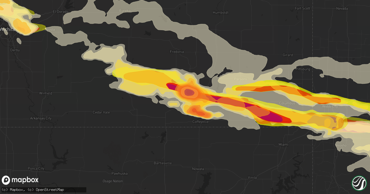
Hail Map in Independence, KS on April 2, 2015
Get this storm
April 2 map
$229
one time, instant access
Download today. No call, no setup
Keep the $229
Bought the map and want the full workflow? Apply the entire $229 to a subscription within 7 days. None of it is wasted.
Every map, not just this one
This buys you this map. Subscription and you get every map we run, in the markets you choose from a few cities to whole states to nationwide. Plus real-time alerts the moment a storm fires.
Contact data
Name, contact info, occupancy, even credit band for addresses in the footprint. You go from where it hit to who to call.
Become the source they trust
Unlimited branding weather history reports on demand. You already have the documented answer ready for the property owner, and you are the one who showed up with it.
Property data and RoofTrace estimates
Pull up any address you have got, its value and the exact code rules for that jurisdiction, straight from One Click Code. Then RoofTrace estimates the squares, pitch, and roof value, priced the way you price.
Storm reports in Independence, KS
Independence, KS
| Date | Description |
|---|---|
| 04/02/20151:46 AM CDT | Viewer of fox23 tulsa sends a pic of grapefruit size hail. Time is based off radar. |
| 04/02/20151:45 AM CDT | A local report indicates 1.50 inch wind near INDEPENDENCE |
| 04/02/20151:44 AM CDT | A local report indicates 1.25 inch wind near 4 SW INDEPENDENCE |
All States Impacted by Hail Map on April 2, 2015
All Cities Impacted by Hail Map on April 2, 2015
- Partridge, KS
- Nickerson, KS
- Abbyville, KS
- Pawhuska, OK
- Peru, KS
- Niotaze, KS
- Rosebud, MO
- Owensville, MO
- Licking, MO
- Miami, OK
- Bradleyville, MO
- Branson, MO
- Ridgedale, MO
- Squires, MO
- Gainesville, MO
- Cedarcreek, MO
- Pontiac, MO
- Powersite, MO
- Hollister, MO
- Forsyth, MO
- Ava, MO
- Kirbyville, MO
- Isabella, MO
- Kissee Mills, MO
- Theodosia, MO
- Rueter, MO
- Thornfield, MO
- Noble, MO
- Salem, AR
- Muldraugh, KY
- Louisville, KY
- Laconia, IN
- Webster, KY
- Brandenburg, KY
- Shepherdsville, KY
- Fort Knox, KY
- Fairdale, KY
- West Point, KY
- Fisherville, KY
- Brooks, KY
- Irvington, KY
- Hardinsburg, KY
- Taylorsville, KY
- Ekron, KY
- Vine Grove, KY
- Guston, KY
- Corydon, IN
- Elizabeth, IN
- Galesburg, KS
- Erie, KS
- Walnut Hill, IL
- Centralia, IL
- Saint Louis, MO
- Millstadt, IL
- Waterloo, IL
- Columbia, IL
- Valmeyer, IL
- Arnold, MO
- Lenapah, OK
- S Coffeyville, OK
- Eureka Springs, AR
- Ness City, KS
- Labadie, MO
- Flippin, AR
- Longton, KS
- Elk Falls, KS
- Chamois, MO
- Linn, MO
- Walnut Ridge, AR
- Golden City, MO
- Lockwood, MO
- Lamar, MO
- Falcon, MO
- Laquey, MO
- Lebanon, MO
- Phillipsburg, MO
- Jeffersonville, IN
- Saint Elmo, IL
- Brownstown, IL
- Mayfield, KY
- Wingo, KY
- Perry, FL
- Chelsea, OK
- Ottawa, KS
- Wellsville, KS
- Seymour, MO
- Oldfield, MO
- Bruner, MO
- Sparta, MO
- Wheatland, MO
- Cross Timbers, MO
- Yellville, AR
- Stockton, MO
- Dickson, TN
- Nunnelly, TN
- Hurricane Mills, TN
- Only, TN
- McEwen, TN
- Lobelville, TN
- Bon Aqua, TN
- Parsons, KS
- Iberia, MO
- Gerald, MO
- Colby, KS
- Brookline, MO
- Springfield, MO
- Chanute, KS
- Thayer, KS
- Mount Vernon, IN
- Dixon, MO
- Thomaston, GA
- Sedan, KS
- Elk City, KS
- Howard, KS
- Moline, KS
- Hutchinson, KS
- Buhler, KS
- Mount Sterling, MO
- Bland, MO
- Beulah, MO
- Sedgwick, KS
- Bentley, KS
- Independence, KS
- Hardy, AR
- Ava, IL
- Great Bend, KS
- St John, KS
- Pawnee Rock, KS
- Birmingham, AL
- Oswego, KS
- Coffeyville, KS
- Chetopa, KS
- McCune, KS
- Joplin, MO
- Fredonia, KS
- Columbus, KS
- Bartlett, KS
- Baxter Springs, KS
- Cherokee, KS
- Neosho, MO
- Webb City, MO
- Scammon, KS
- Pittsburg, KS
- Oronogo, MO
- Edna, KS
- West Mineral, KS
- Cherryvale, KS
- Diamond, MO
- Altamont, KS
- Weir, KS
- Liberty, KS
- Galena, KS
- Mound Valley, KS
- Riverton, KS
- Carl Junction, MO
- El Dorado, KS
- Rosalia, KS
- Vinita, OK
- Bluejacket, OK
- Oaktown, IN
- Whitewater, KS
- Valley Center, KS
- Newton, KS
- Augusta, KS
- South Fulton, TN
- Equality, IL
- Bushnell, FL
- La Grange, KY
- Smithfield, KY
- Crestwood, KY
- Portland, TN
- English, IN
- New Albany, IN
- Saint Croix, IN
- Bristow, IN
- Birdseye, IN
- Lyons, KS
- Alden, KS
- Raymond, KS
- Sterling, KS
- Ellinwood, KS
- Ethel, MS
- Delaware, OK
- Nowata, OK
- Big Cabin, OK
- Adair, OK
- Poplar Bluff, MO
- Edwards, MO
- Quincy, MO
- Warsaw, MO
- Lowry City, MO
- Osceola, MO
- Jasper, MO
- Marshfield, MO
- Salem, MO
- Evansville, IN
- Wakeeney, KS
- Wichita, KS
- Kechi, KS
- Dighton, KS
- Quinter, KS
- Virgil, KS
- Flat Rock, IL
- Carlisle, IN
- Edwardsport, IN
- Palestine, IL
- Carlyle, IL
- Grenola, KS
- Piedmont, KS
- Latham, KS
- West, MS
- Kosciusko, MS
- Golden, MO
- Powell, MO
- Omaha, AR
- Oak Grove, AR
- Pineville, MO
- Eagle Rock, MO
- Shell Knob, MO
- Washburn, MO
- Garfield, AR
- Green Forest, AR
- Berryville, AR
- Seligman, MO
- Sulphur Springs, AR
- Gravette, AR
- Kinsley, KS
- Jay, OK
- Copan, OK
- Hudson, KS
- Welch, OK
- Dewey, OK
- Afton, OK
- Wann, OK
- Granby, MO
- Stark City, MO
- Monett, MO
- Purdy, MO
- Pierce City, MO
- Crocker, MO
- Smithville, AR
- Poughkeepsie, AR
- Frohna, MO
- Dunnegan, MO
- Fair Play, MO
- Aurora, MO
- Cassville, MO
- Mineral Point, MO
- Potosi, MO
- Bonne Terre, MO
- Cadet, MO
- Mill Spring, MO
- Williamsville, MO
- Lane, KS
- Osawatomie, KS
- Scott City, KS
- Carbondale, IL
- Strawberry, AR
- Benton, KY
- Tuscumbia, MO
- Genoa, CO
- Limon, CO
- Carthage, MO
- Murphysboro, IL
- Herrin, IL
- Grand Tower, IL
- De Soto, IL
- Carterville, IL
- Marion, IL
- Makanda, IL
- Cambria, IL
- Pomona, IL
- Leon, KS
- Larned, KS
- Union City, TN
- Martin, TN
- Hume, MO
- Fort Scott, KS
- Towanda, KS
- Benton, KS
- Potwin, KS
- Flagler, CO
- Climax, GA
- Eureka, KS
- Utica, KS
- Claremore, OK
- Pryor, OK
- Kit Carson, CO
- Linton, IN
- Reeds Spring, MO
- Bloomfield, IN
- Owensburg, IN
- Stafford, KS
- Sylvia, KS
- Bloomfield, KY
- Wentworth, MO
- Burns, KS
- Little River, KS
- Chase, KS
- Inman, KS
- Haven, KS
- Fall River, KS
- Toronto, KS
- Grandin, MO
- Ellsinore, MO
- Cannelton, IN
- Battletown, KY
- Leavenworth, IN
- Cassoday, KS
- Exeter, MO
- Rogersville, MO
- Andover, KS
- Protem, MO
- Sarcoxie, MO
- Marionville, MO
- Verona, MO
- Crane, MO
- Galena, MO
- Beeler, KS
- Norfork, AR
- Calico Rock, AR
- Violet Hill, AR
- Dolph, AR
- Wideman, AR
- Mountain Home, AR
- Pineville, AR
- Oxford, AR
- Brockwell, AR
- Maize, KS
- Shelbyville, KY
- Pewee Valley, KY
- Burdett, KS
- Rozel, KS
- Hoxie, KS
- Cave In Rock, IL
- Harrisburg, IL
- Eddyville, IL
- Stonefort, IL
- Elizabethtown, IL
- Herod, IL
- Junction, IL
- Carrier Mills, IL
- Shawneetown, IL
- Eucha, OK
- Yates Center, KS
- Catawissa, MO
- Robertsville, MO
- Villa Ridge, MO
- Union, MO
- Saint Clair, MO
- Creighton, MO
- Harrisonville, MO
- Drexel, MO
- Garden City, MO
- Archie, MO
- Bois D Arc, MO
- Miller, MO
- Everton, MO
- Ash Grove, MO
- Willard, MO
- Bakersfield, MO
- Henderson, AR
- Gepp, AR
- Camp, AR
- Sturkie, AR
- Gamaliel, AR
- Viola, AR
- Mammoth Spring, AR
- Clarkridge, AR
- Hanston, KS
- Greenfield, MO
- Niangua, MO
- Grovespring, MO
- Durant, MS
- Sallis, MS
- Derby, KS
- Mount Washington, KY
- Walnut Shade, MO
- Cloverport, KY
- Hawesville, KY
- Reynolds Station, KY
- Plato, MO
- Duke, MO
- Central, IN
- Mauckport, IN
- Benedict, KS
- Caney, KS
- Mcconnell Afb, KS
- Aldrich, MO
- Smithton, IL
- New Athens, IL
- Freeburg, IL
- South West City, MO
- Rush Center, KS
- Vanzant, MO
- Dora, MO
- Glenview, KY
- Clarksville, IN
- Masonic Home, KY
- Mascoutah, IL
- Hermann, MO
- Morrison, MO
- Elbing, KS
- Morgantown, KY
- Butterfield, MO
- Colwich, KS
- Asbury, MO
- Neodesha, KS
- Rocky Comfort, MO
- Wheaton, MO
- Quapaw, OK
- Spokane, MO
- Reeds, MO
- Cape Fair, MO
- Carterville, MO
- Girard, KS
- Fairview, MO
- Dennis, KS
- Billings, MO
- Stella, MO
- Ponce De Leon, MO
- Grove, OK
- Mayo, FL
- Ash Flat, AR
- Evening Shade, AR
- Horseshoe Bend, AR
- Bartlesville, OK
- West Plains, MO
- Willow Springs, MO
- Harrison, AR
- Gassville, AR
- Franklin, AR
- Cotter, AR
- Lakeview, AR
- Ellington, MO
- Richmond, KS
- Macomb, MO
- Saint Paul, KS
- Buffalo, KS
- Mount Hope, KS
- Greenwich, KS
- Burrton, KS
- Highlandville, MO
- Imperial, MO
- Norwood, MO
- Piedmont, MO
- Havana, KS
- Buffalo, MO
- Half Way, MO
- High Ridge, MO
- Fenton, MO
- Belleville, IL
- Lenzburg, IL
- Douglass, KS
- Stotts City, MO
- Oakley, KS
- Strang, OK
- Collinsville, OK
- Owasso, OK
- Cherokee Village, AR
- Louisburg, KS
- Fontana, KS
- Rantoul, KS
- Paola, KS
- Urich, MO
- Blairstown, MO
- Frontenac, KS
- Liberal, MO
- Mindenmines, MO
- Bull Shoals, AR
- Washington, MO
- Lyons, IN
- Forsyth, GA
- Leslie, MO
- Beaufort, MO
- Sullivan, MO
- Hartshorn, MO
- Eminence, MO
- Adrian, MO
- Wyandotte, OK
- Seneca, MO
- Tiff City, MO
- Bella Vista, AR
- Fairland, OK
- Noel, MO
- Anderson, MO
- North Miami, OK
- Goodman, MO
- Commerce, OK
- Lanagan, MO
- Lampe, MO
- Pea Ridge, AR
- Long Lane, MO
- Fordland, MO
- Moody, MO
- Caulfield, MO
- Lexington, MS
- Chestnutridge, MO
- Duenweg, MO
- Cambridge, KS
- La Russell, MO
- Mansfield, MO
- Otis, KS
- Albert, KS
- Hartville, MO
- Branchville, IN
- Tell City, IN
- Lanesville, IN
- New Middletown, IN
- Georgetown, IN
- Sulphur, IN
- Leopold, IN
- Harned, KY
- Garfield, KS
- Wappapello, MO
- McGee, MO
- Puxico, MO
- Solsberry, IN
- Bloomington, IN
- Freedom, IN
- Worthington, IN
- Ellettsville, IN
- Gosport, IN
- Spencer, IN
- Conway, MO
- Saint Elizabeth, MO
- Meta, MO
- Severy, KS
- Drury, MO
- Halltown, MO
- Republic, MO
- Cedar Hill, MO
- Jerico Springs, MO
- Caneyville, KY
- East Prairie, MO
- Collyer, KS
- Sandborn, IN
- Jetmore, KS
- Fulton, KY
- Sedalia, KY
- Yatesville, GA
- Barnesville, GA
- Derby, IN
- Prospect, KY
- Finchville, KY
- Bagdad, KY
- Depauw, IN
- Marengo, IN
- Grantsburg, IN
- Milltown, IN
- Henderson, KY
- Mount Vernon, MO
- Perryville, MO
- Pell City, AL
- Mulvane, KS
- Crane, IN
- Springville, IN
- Selden, KS
- Taneyville, MO
- Mountain Grove, MO
- Barnhart, MO
- South Greenfield, MO
- Kirksey, KY
- Cadiz, KY
- Kuttawa, KY
- Gilbertsville, KY
- Owenton, KY
- Sadieville, KY
- Corinth, KY
- Stamping Ground, KY
- Hugo, CO
- Dadeville, MO
- Chilhowee, MO
- Lead Hill, AR
- Wiseman, AR
- Elizabeth, AR
- Jacob, IL
- Clever, MO
- Walnut Grove, MO
- Leeds, AL
- Rockaway Beach, MO
- Pomona, MO
- Coxs Creek, KY
- Greenville, FL
- Osage Beach, MO
- Johnston City, IL
- West Frankfort, IL
- Saint Thomas, MO
- Sterrett, AL
- Chelsea, AL
- House Springs, MO
- Richview, IL
- Healy, KS
- Nekoma, KS
- Alexander, KS
- Cleveland, MO
- Frankfort, KY
- Peace Valley, MO
- Walton, KS
- Birch Tree, MO
- Altoona, KS
- Rosiclare, IL
- Golconda, IL
- Roach, MO
- Hoyleton, IL
- Nashville, IL
- Olney, IL
- Hamilton, KS
- Greenville, MO
- Burlington, CO
- Belle, MO
- Westphalia, MO
- Loose Creek, MO
- Simpsonville, KY
- Farmington, KY
- Hazel, KY
- Atlanta, KS
- Neal, KS
- Blue Eye, MO
- Walnut, KS
- Wasola, MO
- Hardenville, MO
- Kimberling City, MO
- Udall, MO
- Tecumseh, MO
- Arcola, MO
- Rexford, KS
- Marion, KY
- Lawrenceville, IL
- Sullivan, IN
- Dugger, IN
- Rolla, MO
- Newburg, MO
- Vienna, MO
- Picher, OK
- Lynchburg, MO
- Halstead, KS
- Cheyenne Wells, CO
- Falmouth, KY
- Williamstown, KY
- Simpson, IL
- Ozark, IL
- Royalton, IL
- Mulkeytown, IL
- Ridgway, IL
- Palmersville, TN
- Dukedom, TN
- Elkland, MO
- Falls Of Rough, KY
- Williford, AR
- Ravenden, AR
- Vandiver, AL
- Keenes, IL
- Bluford, IL
- Bourbon, MO
- Union Star, KY
- Payneville, KY
- Rhodelia, KY
- Madison, KS
- Sumterville, FL
- Centerville, TN
- Nixa, MO
- Ozark, MO
- Winona, MO
- Peculiar, MO
- Lebanon Junction, KY
- Arriba, CO
- Ballwin, MO
- Wildwood, MO
- Pacific, MO
- Steelville, MO
- Philpot, KY
- Switz City, IN
- Unionville, IN
- Nashville, IN
- Mulberry, KS
- Franklin, KS
- Edgar Springs, MO


