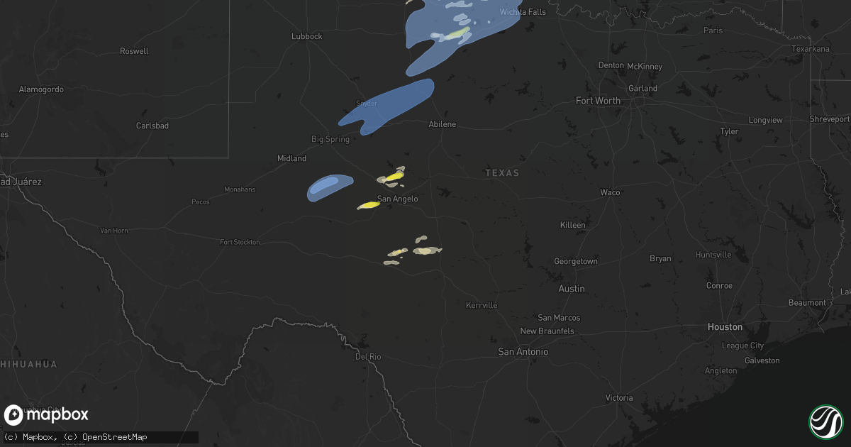
Hail Map in Texas on April 1, 2026
Get this storm
April 1 map
$229
one time, instant access
Download today. No call, no setup
Keep the $229
Bought the map and want the full workflow? Apply the entire $229 to a subscription within 7 days. None of it is wasted.
Every map, not just this one
This buys you this map. Subscription and you get every map we run, in the markets you choose from a few cities to whole states to nationwide. Plus real-time alerts the moment a storm fires.
Contact data
Name, contact info, occupancy, even credit band for addresses in the footprint. You go from where it hit to who to call.
Become the source they trust
Unlimited branding weather history reports on demand. You already have the documented answer ready for the property owner, and you are the one who showed up with it.
Property data and RoofTrace estimates
Pull up any address you have got, its value and the exact code rules for that jurisdiction, straight from One Click Code. Then RoofTrace estimates the squares, pitch, and roof value, priced the way you price.
Storm reports in Texas
Texas
| Date | Description |
|---|---|
| 04/01/20266:57 PM CDT | A local report indicates 61 MPH wind near 3 E Snyder |
| 04/01/20266:50 PM CDT | A local report indicates 66 MPH wind near 3 SSW Snyder |
| 04/01/20266:38 PM CDT | Initial gust of 69 mph at 6:36 pm cdt. West texas mesonet. |
| 04/01/20266:31 PM CDT | Power poles/lines down. |
| 04/01/20265:45 PM CDT | West texas mesonet. |
| 04/01/20265:40 PM CDT | Also gusted to 61 mph at 536 pm cdt. Measured by childress asos. |
| 03/31/20269:22 PM CDT | A local report indicates 62 MPH wind near 1 S Mankins |
| 03/31/20268:50 PM CDT | A local report indicates 69 MPH wind near 3 NW Seymour |
| 03/31/20268:30 PM CDT | A local report indicates 60 MPH wind near 4 NNW Goree |
| 03/31/20268:30 PM CDT | A local report indicates 60 MPH wind near 3 NW Knox City |
| 03/31/20268:30 PM CDT | A local report indicates 60 MPH wind near 6 NE Munday |
| 03/31/20268:22 PM CDT | A local report indicates 62 MPH wind near Weinert |
| 03/31/20268:20 PM CDT | A local report indicates 72 MPH wind near 3 NW Knox City |
| 03/31/20268:15 PM CDT | A local report indicates 72 MPH wind near 3 NW Knox City |
| 03/31/20268:09 PM CDT | Roof damage. |
| 03/31/20268:02 PM CDT | A local report indicates 75 MPH wind near 5 SW Saint Lawrence |
| 03/31/20267:50 PM CDT | Couple power lines blown down in town. |
| 03/31/20267:27 PM CDT | A local report indicates 65 MPH wind near Rotan |
| 03/31/20267:27 PM CDT | Delayed report. Report from mping: quarter |
All States Impacted by Hail Map on April 1, 2026
Cities Impacted by Hail Map on April 1, 2026
- London, KY
- Norris City, IL
- Enfield, IL
- Broughton, IL
- McLeansboro, IL
- Welch, WV
- Jackson, KY
- Gays Creek, KY
- Buckhorn, KY
- Anawalt, WV
- Carmi, IL
- Maybeury, WV
- Ulysses, KY
- Louisa, KY
- Bedford, VA
- Fort Gay, WV
- Warfield, KY
- Kermit, WV
- Inez, KY
- Crum, WV
- Boone, NC
- Deep Gap, NC
- Hyden, KY
- Caldwell, OH
- Sarahsville, OH
- Summerfield, OH
- Lewisville, OH
- Wooton, KY
- Hazard, KY
- Fleetwood, NC
- Wilsondale, WV
- Breeden, WV
- Tomahawk, KY
- French Lick, IN
- Krypton, KY
- Dubois, IN
- Debord, KY
- Viper, KY
- Forest, VA
- Goode, VA
- Lynchburg, VA
- Elberfeld, IN
- Harts, WV
- Dingess, WV
- Purlear, NC
- Ellington, MO
- Woodsfield, OH
- Chapmanville, WV
- Jerusalem, OH
- Redford, MO
- Big Creek, WV
- Pilgrim, KY
- Lynnville, IN
- Orleans, IN
- Campbellsburg, IN
- Lesterville, MO
- Rockbridge, OH
- Laurelville, OH
- Stockport, OH
- Malta, OH
- Lovely, KY
- Lenore, WV
- Williamson, WV
- Salem, IN
- Beallsville, OH
- Cameron, OH
- Clarington, OH
- Proctor, WV
- Glen Easton, WV
- Omar, WV
- Delbarton, WV
- Millers Creek, NC
- Holden, WV
- Scottsburg, IN
- Annapolis, MO
- Pecks Mill, WV
- New Martinsville, WV
- Cameron, WV
- Collinsville, MS
- Sarah Ann, WV
- Bim, WV
- Clothier, WV
- Columbus, MS
- Bogalusa, LA
- Lowry, VA
- Ezel, KY
- West Liberty, KY
- Littleton, WV
- Friendsville, MD
- Bruceton Mills, WV
- Louisville, KY
- West Point, MS
- Fisherville, KY
- Wana, WV
- Mannington, WV
- Metz, WV
- Cutler, OH
- Chesterhill, OH
- Amesville, OH
- Rock Creek, WV
- Hundred, WV
- Burton, WV
- Waterford, OH
- Elkfork, KY
- Monticello, GA
- Franklinton, LA
- Simpsonville, KY
- Shelbyville, KY
- Finchville, KY
- Hardyville, KY
- Canmer, KY
- Munfordville, KY
- Manassas, VA
- Vincent, OH
- Fleming, OH
- Frostburg, MD
- Fairview, WV
- Whipple, OH
- Marietta, OH
- Lowell, OH
- Williamstown, WV
- Rivesville, WV
- Summersville, KY
- Magnolia, KY
- Reynolds, GA
- Butler, GA
- Salisbury, PA
- Guysville, OH
- Stewart, OH
- Newport, OH
- Reno, OH
- Coolville, OH
- Alma, WV
- Jacksonburg, WV
- West Union, WV
- Flat Top, WV
- Flag Pond, TN
- Hyndman, PA
- Bristow, VA
- Gainesville, VA
- Pine Grove, WV
- Reader, WV
- Greensburg, KY
- Belmont, WV
- Saint Marys, WV
- Little Hocking, OH
- Belpre, OH
- Center Point, WV
- Maidsville, WV
- Bardstown, KY
- Rachel, WV
- Farmington, WV
- Fairmont, WV
- Ballard, WV
- Troutville, VA
- Thomas, OK
- Middleport, OH
- Washington, WV
- Monroe, VA
- Forest Hill, WV
- Pipestem, WV
- Coxs Creek, KY
- Rutland, OH
- Pomeroy, OH
- Cheshire, OH
- Beverly, OH
- Masontown, WV
- Lerona, WV
- Parkersburg, WV
- Vienna, WV
- Waverly, WV
- Morgantown, WV
- Albright, WV
- Racine, OH
- New Haven, WV
- Hartford, WV
- Mason, WV
- Syracuse, OH
- Letart, WV
- West Columbia, WV
- Roanoke, VA
- Baxter, WV
- Fay, OK
- Watonga, OK
- Paris, KY
- Oakwood, OK
- Campton, KY
- Salyersville, KY
- Sandy Hook, KY
- Canton, OK
- Hinton, WV
- Friendly, WV
- Walker, WV
- New Castle, VA
- Sharpsburg, KY
- Carlisle, KY
- Bidwell, OH
- Gallipolis, OH
- Big Island, VA
- Matador, TX
- Hitchcock, OK
- Okeene, OK
- Cairo, WV
- Ellenboro, WV
- Cee Vee, TX
- Childress, TX
- Greenfield, OK
- Enid, OK
- Geary, OK
- Petroleum, WV
- Owingsville, KY
- Hedgesville, WV
- Wellington, KY
- Paducah, TX
- Fairmont, OK
- Garber, OK
- Hillsboro, KY
- Frenchburg, KY
- Tell, TX
- Kingwood, WV
- Kingfisher, OK
- Quanah, TX
- Crowell, TX
- Pennsboro, WV
- Rineyville, KY
- Cecilia, KY
- Lamar, MO
- Custer, KY
- Mulhall, OK
- Orlando, OK
- Whitesville, WV
- Glen Daniel, WV
- Beckley, WV
- Hennessey, OK
- Sheldon, MO
- Dover, OK
- Eastview, KY
- Hunter, OK
- Spout Spring, VA
- Appomattox, VA
- Hollis, OK
- Gould, OK
- Eldorado, OK
- Chillicothe, TX
- Duke, OK
- Vinson, OK
- Mangum, OK
- Dill City, OK
- Sentinel, OK
- Omega, OK
- Marshall, OK
- Athens, OH
- Elizabethtown, KY
- Long Bottom, OH
- Wellington, TX
- Erick, OK
- Shade, OH
- Red Rock, OK
- Billings, OK
- Cordell, OK
- Vernon, TX
- Odell, TX
- Olustee, OK
- Altus, OK
- Elmer, OK
- Blair, OK
- Crescent, OK
- Covington, OK
- Perry, OK
- Texola, OK
- Foss, OK
- Middlebourne, WV
- Salem, WV
- Seymour, TX
- Old Glory, TX
- Bridgeport, WV
- Clarksburg, WV
- Mount Clare, WV
- Anmoore, WV
- Meadowbrook, WV
- Corn, OK
- Morrison, OK
- Pawnee, OK
- Bessie, OK
- Willow, OK
- Granite, OK
- Carter, OK
- Lone Wolf, OK
- Altus Afb, OK
- Headrick, OK
- Mountain Park, OK
- Roosevelt, OK
- Tipton, OK
- Ralston, OK
- Clinton, OK
- Weatherford, OK
- Falling Waters, WV
- Williamsport, MD
- Frederick, OK
- Benjamin, TX
- Rocky, OK
- Hobart, OK
- Snyder, OK
- Davidson, OK
- Oklaunion, TX
- Harrold, TX
- Stillwater, OK
- Coleman Falls, VA
- Fairfax, OK
- Hydro, OK
- Gotebo, OK
- Electra, TX
- Hollister, OK
- Loraine, TX
- Roscoe, TX
- Sweetwater, TX
- Colorado City, TX
- Munday, TX
- Rustburg, VA
- Salem, VA
- Roby, TX
- Hermleigh, TX
- McCaulley, TX
- Sylvester, TX
- Snyder, TX
- Rotan, TX
- Jayton, TX
- Aspermont, TX
- Rochester, TX
- O'Brien, TX
- Rule, TX
- Goree, TX
- Hominy, OK
- Daleville, VA
- Walters, OK
- Lawton, OK
- Mountain View, OK
- Faxon, OK
- Indiahoma, OK
- Chattanooga, OK
- Devol, OK
- Randlett, OK
- Cache, OK
- Loveland, OK
- Grandfield, OK
- Knox City, TX
- Haskell, TX
- Weinert, TX
- Anson, TX
- Hamlin, TX
- Carnegie, OK
- Elgin, OK
- Apache, OK
- Medicine Park, OK
- Fort Cobb, OK
- Anadarko, OK
- Pocasset, OK
- Gracemont, OK
- Lookeba, OK
- Hinton, OK
- Minco, OK
- Binger, OK
- Colony, OK
- Calumet, OK
- Okarche, OK
- El Reno, OK
- Union City, OK
- Wynona, OK
- Saint Albans, WV
- Hurricane, WV
- Maramec, OK
- Cleveland, OK
- Jennings, OK
- Burkburnett, TX
- Iowa Park, TX
- Stamford, TX
- Wichita Falls, TX
- Sheppard Afb, TX
- Yale, OK
- Waukomis, OK
- Terlton, OK
- Barnsdall, OK
- Chickasha, OK
- Verden, OK
- Yukon, OK
- Holliday, TX
- Temple, OK
- Osage, OK
- Piedmont, OK
- Pawhuska, OK
- Martha, KY
- Avenue, MD
- Abell, MD
- Bushwood, MD
- Leonardtown, MD
- Robert Lee, TX
- Mechanicsville, MD
- Hollywood, MD
- California, MD
- Bronte, TX
- Carlsbad, TX
- Georgetown, DE
- Mertzon, TX
- Millsboro, DE
- San Angelo, TX
- Menard, TX
- Eldorado, TX
- Daniels, WV
- Beaver, WV
- Pickrell, NE
- Cortland, NE
- Sonora, TX
- Ira, TX
- Coahoma, TX
- Westbrook, TX
- Big Spring, TX
- Sterling City, TX
- Garden City, TX
- Midkiff, TX
- Big Lake, TX
- Tatum, NM
- Portland, OH
- Jumping Branch, WV


