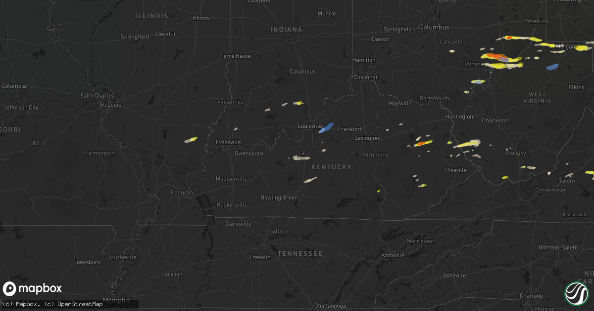
Hail Map in Kentucky on April 1, 2026
Get this storm
April 1 map
$229
one time, instant access
Download today. No call, no setup
Keep the $229
Bought the map and want the full workflow? Apply the entire $229 to a subscription within 7 days. None of it is wasted.
Every map, not just this one
This buys you this map. Subscription and you get every map we run, in the markets you choose from a few cities to whole states to nationwide. Plus real-time alerts the moment a storm fires.
Contact data
Name, contact info, occupancy, even credit band for addresses in the footprint. You go from where it hit to who to call.
Become the source they trust
Unlimited branding weather history reports on demand. You already have the documented answer ready for the property owner, and you are the one who showed up with it.
Property data and RoofTrace estimates
Pull up any address you have got, its value and the exact code rules for that jurisdiction, straight from One Click Code. Then RoofTrace estimates the squares, pitch, and roof value, priced the way you price.
Storm reports in Kentucky
Kentucky
| Date | Description |
|---|---|
| 04/01/20264:41 PM CDT | Broadcast media relayed pictures of a metal garage roof torn off. Time estimated from radar. |
| 04/01/20264:25 PM CDT | Tree down across road blocking the entire road on town hill road. Time estimated by radar. |
| 04/01/20263:59 PM CDT | Tree down blocking roadway on sims cemetery rd. Time estimated from radar. |
| 04/01/20263:49 PM CDT | Social media video of lots of hail falling along ky-589... About 1.5 miles from its intersection with ky-172. The individual reports that the largest hail stones were q |
| 04/01/20263:29 PM CDT | Social media user posted a video of hail and reported golf ball sized hailstones near the intersection of ky519 and ky7. Time estimated by radar. |
| 04/01/20263:27 PM CDT | Small branches down with heavy rain... At least 60 mph winds. |
| 04/01/20263:27 PM CDT | Social media user shared photo of hail stone and estimates ping pong size. Hail was retrieved off of liberty rd near arh hospital. Time estimated from radar. |
| 04/01/20263:20 PM CDT | Social media video shows pile of approximately quarter sized hail near west liberty. Time estimated by radar. |
| 04/01/202612:51 PM CDT | Tree damage resulting in 54 customers without power. |
All States Impacted by Hail Map on April 1, 2026
Cities Impacted by Hail Map on April 1, 2026
- London, KY
- Norris City, IL
- Enfield, IL
- Broughton, IL
- McLeansboro, IL
- Welch, WV
- Jackson, KY
- Gays Creek, KY
- Buckhorn, KY
- Anawalt, WV
- Carmi, IL
- Maybeury, WV
- Ulysses, KY
- Louisa, KY
- Bedford, VA
- Fort Gay, WV
- Warfield, KY
- Kermit, WV
- Inez, KY
- Crum, WV
- Boone, NC
- Deep Gap, NC
- Hyden, KY
- Caldwell, OH
- Sarahsville, OH
- Summerfield, OH
- Lewisville, OH
- Wooton, KY
- Hazard, KY
- Fleetwood, NC
- Wilsondale, WV
- Breeden, WV
- Tomahawk, KY
- French Lick, IN
- Krypton, KY
- Dubois, IN
- Debord, KY
- Viper, KY
- Forest, VA
- Goode, VA
- Lynchburg, VA
- Elberfeld, IN
- Harts, WV
- Dingess, WV
- Purlear, NC
- Ellington, MO
- Woodsfield, OH
- Chapmanville, WV
- Jerusalem, OH
- Redford, MO
- Big Creek, WV
- Pilgrim, KY
- Lynnville, IN
- Orleans, IN
- Campbellsburg, IN
- Lesterville, MO
- Rockbridge, OH
- Laurelville, OH
- Stockport, OH
- Malta, OH
- Lovely, KY
- Lenore, WV
- Williamson, WV
- Salem, IN
- Beallsville, OH
- Cameron, OH
- Clarington, OH
- Proctor, WV
- Glen Easton, WV
- Omar, WV
- Delbarton, WV
- Millers Creek, NC
- Holden, WV
- Scottsburg, IN
- Annapolis, MO
- Pecks Mill, WV
- New Martinsville, WV
- Cameron, WV
- Collinsville, MS
- Sarah Ann, WV
- Bim, WV
- Clothier, WV
- Columbus, MS
- Bogalusa, LA
- Lowry, VA
- Ezel, KY
- West Liberty, KY
- Littleton, WV
- Friendsville, MD
- Bruceton Mills, WV
- Louisville, KY
- West Point, MS
- Fisherville, KY
- Wana, WV
- Mannington, WV
- Metz, WV
- Cutler, OH
- Chesterhill, OH
- Amesville, OH
- Rock Creek, WV
- Hundred, WV
- Burton, WV
- Waterford, OH
- Elkfork, KY
- Monticello, GA
- Franklinton, LA
- Simpsonville, KY
- Shelbyville, KY
- Finchville, KY
- Hardyville, KY
- Canmer, KY
- Munfordville, KY
- Manassas, VA
- Vincent, OH
- Fleming, OH
- Frostburg, MD
- Fairview, WV
- Whipple, OH
- Marietta, OH
- Lowell, OH
- Williamstown, WV
- Rivesville, WV
- Summersville, KY
- Magnolia, KY
- Reynolds, GA
- Butler, GA
- Salisbury, PA
- Guysville, OH
- Stewart, OH
- Newport, OH
- Reno, OH
- Coolville, OH
- Alma, WV
- Jacksonburg, WV
- West Union, WV
- Flat Top, WV
- Flag Pond, TN
- Hyndman, PA
- Bristow, VA
- Gainesville, VA
- Pine Grove, WV
- Reader, WV
- Greensburg, KY
- Belmont, WV
- Saint Marys, WV
- Little Hocking, OH
- Belpre, OH
- Center Point, WV
- Maidsville, WV
- Bardstown, KY
- Rachel, WV
- Farmington, WV
- Fairmont, WV
- Ballard, WV
- Troutville, VA
- Thomas, OK
- Middleport, OH
- Washington, WV
- Monroe, VA
- Forest Hill, WV
- Pipestem, WV
- Coxs Creek, KY
- Rutland, OH
- Pomeroy, OH
- Cheshire, OH
- Beverly, OH
- Masontown, WV
- Lerona, WV
- Parkersburg, WV
- Vienna, WV
- Waverly, WV
- Morgantown, WV
- Albright, WV
- Racine, OH
- New Haven, WV
- Hartford, WV
- Mason, WV
- Syracuse, OH
- Letart, WV
- West Columbia, WV
- Roanoke, VA
- Baxter, WV
- Fay, OK
- Watonga, OK
- Paris, KY
- Oakwood, OK
- Campton, KY
- Salyersville, KY
- Sandy Hook, KY
- Canton, OK
- Hinton, WV
- Friendly, WV
- Walker, WV
- New Castle, VA
- Sharpsburg, KY
- Carlisle, KY
- Bidwell, OH
- Gallipolis, OH
- Big Island, VA
- Matador, TX
- Hitchcock, OK
- Okeene, OK
- Cairo, WV
- Ellenboro, WV
- Cee Vee, TX
- Childress, TX
- Greenfield, OK
- Enid, OK
- Geary, OK
- Petroleum, WV
- Owingsville, KY
- Hedgesville, WV
- Wellington, KY
- Paducah, TX
- Fairmont, OK
- Garber, OK
- Hillsboro, KY
- Frenchburg, KY
- Tell, TX
- Kingwood, WV
- Kingfisher, OK
- Quanah, TX
- Crowell, TX
- Pennsboro, WV
- Rineyville, KY
- Cecilia, KY
- Lamar, MO
- Custer, KY
- Mulhall, OK
- Orlando, OK
- Whitesville, WV
- Glen Daniel, WV
- Beckley, WV
- Hennessey, OK
- Sheldon, MO
- Dover, OK
- Eastview, KY
- Hunter, OK
- Spout Spring, VA
- Appomattox, VA
- Hollis, OK
- Gould, OK
- Eldorado, OK
- Chillicothe, TX
- Duke, OK
- Vinson, OK
- Mangum, OK
- Dill City, OK
- Sentinel, OK
- Omega, OK
- Marshall, OK
- Athens, OH
- Elizabethtown, KY
- Long Bottom, OH
- Wellington, TX
- Erick, OK
- Shade, OH
- Red Rock, OK
- Billings, OK
- Cordell, OK
- Vernon, TX
- Odell, TX
- Olustee, OK
- Altus, OK
- Elmer, OK
- Blair, OK
- Crescent, OK
- Covington, OK
- Perry, OK
- Texola, OK
- Foss, OK
- Middlebourne, WV
- Salem, WV
- Seymour, TX
- Old Glory, TX
- Bridgeport, WV
- Clarksburg, WV
- Mount Clare, WV
- Anmoore, WV
- Meadowbrook, WV
- Corn, OK
- Morrison, OK
- Pawnee, OK
- Bessie, OK
- Willow, OK
- Granite, OK
- Carter, OK
- Lone Wolf, OK
- Altus Afb, OK
- Headrick, OK
- Mountain Park, OK
- Roosevelt, OK
- Tipton, OK
- Ralston, OK
- Clinton, OK
- Weatherford, OK
- Falling Waters, WV
- Williamsport, MD
- Frederick, OK
- Benjamin, TX
- Rocky, OK
- Hobart, OK
- Snyder, OK
- Davidson, OK
- Oklaunion, TX
- Harrold, TX
- Stillwater, OK
- Coleman Falls, VA
- Fairfax, OK
- Hydro, OK
- Gotebo, OK
- Electra, TX
- Hollister, OK
- Loraine, TX
- Roscoe, TX
- Sweetwater, TX
- Colorado City, TX
- Munday, TX
- Rustburg, VA
- Salem, VA
- Roby, TX
- Hermleigh, TX
- McCaulley, TX
- Sylvester, TX
- Snyder, TX
- Rotan, TX
- Jayton, TX
- Aspermont, TX
- Rochester, TX
- O'Brien, TX
- Rule, TX
- Goree, TX
- Hominy, OK
- Daleville, VA
- Walters, OK
- Lawton, OK
- Mountain View, OK
- Faxon, OK
- Indiahoma, OK
- Chattanooga, OK
- Devol, OK
- Randlett, OK
- Cache, OK
- Loveland, OK
- Grandfield, OK
- Knox City, TX
- Haskell, TX
- Weinert, TX
- Anson, TX
- Hamlin, TX
- Carnegie, OK
- Elgin, OK
- Apache, OK
- Medicine Park, OK
- Fort Cobb, OK
- Anadarko, OK
- Pocasset, OK
- Gracemont, OK
- Lookeba, OK
- Hinton, OK
- Minco, OK
- Binger, OK
- Colony, OK
- Calumet, OK
- Okarche, OK
- El Reno, OK
- Union City, OK
- Wynona, OK
- Saint Albans, WV
- Hurricane, WV
- Maramec, OK
- Cleveland, OK
- Jennings, OK
- Burkburnett, TX
- Iowa Park, TX
- Stamford, TX
- Wichita Falls, TX
- Sheppard Afb, TX
- Yale, OK
- Waukomis, OK
- Terlton, OK
- Barnsdall, OK
- Chickasha, OK
- Verden, OK
- Yukon, OK
- Holliday, TX
- Temple, OK
- Osage, OK
- Piedmont, OK
- Pawhuska, OK
- Martha, KY
- Avenue, MD
- Abell, MD
- Bushwood, MD
- Leonardtown, MD
- Robert Lee, TX
- Mechanicsville, MD
- Hollywood, MD
- California, MD
- Bronte, TX
- Carlsbad, TX
- Georgetown, DE
- Mertzon, TX
- Millsboro, DE
- San Angelo, TX
- Menard, TX
- Eldorado, TX
- Daniels, WV
- Beaver, WV
- Pickrell, NE
- Cortland, NE
- Sonora, TX
- Ira, TX
- Coahoma, TX
- Westbrook, TX
- Big Spring, TX
- Sterling City, TX
- Garden City, TX
- Midkiff, TX
- Big Lake, TX
- Tatum, NM
- Portland, OH
- Jumping Branch, WV


