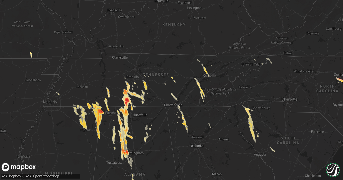
Hail Map in Tennessee on March 31, 2012
Get this storm
March 31 map
$229
one time, instant access
Download today. No call, no setup
Keep the $229
Bought the map and want the full workflow? Apply the entire $229 to a subscription within 7 days. None of it is wasted.
Every map, not just this one
This buys you this map. Subscription and you get every map we run, in the markets you choose from a few cities to whole states to nationwide. Plus real-time alerts the moment a storm fires.
Contact data
Name, contact info, occupancy, even credit band for addresses in the footprint. You go from where it hit to who to call.
Become the source they trust
Unlimited branding weather history reports on demand. You already have the documented answer ready for the property owner, and you are the one who showed up with it.
Property data and RoofTrace estimates
Pull up any address you have got, its value and the exact code rules for that jurisdiction, straight from One Click Code. Then RoofTrace estimates the squares, pitch, and roof value, priced the way you price.
Storm reports in Tennessee
Tennessee
| Date | Description |
|---|---|
| 03/31/20126:57 PM CDT | Dime to quarter size hail in madge near the shelby/tipton county border. |
| 03/31/20126:26 PM CDT | Quarter size hail covering the ground. |
| 03/31/20126:24 PM CDT | A local report indicates 1.00 inch wind near MUNFORD |
| 03/31/20125:45 PM CDT | Quarter sized hail was reported on highway 50 near the lincoln county line. Time estimated by radar. |
| 03/31/20125:35 PM CDT | Trees and power lines were knocked down on highway 129 near the bedford county line. Time estimated by radar. |
| 03/31/20125:20 PM CDT | A local report indicates 1.00 inch wind near PETERSBURG |
| 03/31/20125:01 PM CDT | A local report indicates 1.00 inch wind near 2 S LEWISBURG |
| 03/31/20124:56 PM CDT | Hail reported near highway 31 just south of lewisburg |
| 03/31/20124:55 PM CDT | A local report indicates 1.25 inch wind near LEWISBURG |
| 03/31/20124:30 PM CDT | A local report indicates 1.75 inch wind near COLLINWOOD |
| 03/31/20124:20 PM CDT | A local report indicates 2.00 inch wind near PULASKI |
| 03/31/20124:11 PM CDT | A local report indicates 2.75 inch wind near 8 S PULASKI |
| 03/31/20124:10 PM CDT | Wind damage to carports and some roof damage in minor hill. |
| 03/31/20124:10 PM CDT | A local report indicates 1.25 inch wind near WAYNESBORO |
| 03/31/20124:08 PM CDT | 1.4 inch hail reported in minor hill |
| 03/31/20124:00 PM CDT | Some metal blown off roof barns and some trees were downed along with windows broken in some buildings across the county. Some of this damage was reported in goodspring |
| 03/31/20124:00 PM CDT | Quarter size hail was reported. |
| 03/31/20124:00 PM CDT | A local report indicates 1.75 inch wind near WAYNESBORO |
| 03/31/20123:58 PM CDT | A local report indicates 1.75 inch wind near 8 S PULASKI |
| 03/31/20123:36 PM CDT | Baseball to softball sized hail reported just south of pulaski. |
| 03/31/20123:36 PM CDT | A local report indicates 1.75 inch wind near TARIFFVILLE |
| 03/31/20123:35 PM CDT | Reported to have occurred in flatwoods. |
| 03/31/20123:25 PM CDT | Hail ranged from dime to half dollar size. |
| 03/31/20123:24 PM CDT | A local report indicates 1.00 inch wind near SODDY-DAISY |
| 03/31/20123:19 PM CDT | A local report indicates 1.25 inch wind near 1 S PULASKI |
| 03/31/20123:18 PM CDT | A local report indicates 1.00 inch wind near KNOXVILLE |
| 03/31/20123:12 PM CDT | A local report indicates 1.75 inch wind near TARIFFVILLE |
| 03/31/20123:12 PM CDT | Penny to quarter sized hail. |
| 03/31/20122:45 PM CDT | Quarter size hail was reported in the eastern portion of the chestnut ridge community. |
| 03/31/20122:42 PM CDT | A local report indicates 1.50 inch wind near 1 ENE CLINTON |
| 03/31/20122:35 PM CDT | A local report indicates 1.75 inch wind near LOUDON |
| 03/31/20122:32 PM CDT | A local report indicates 1.00 inch wind near COLUMBIA |
| 03/31/20122:30 PM CDT | A local report indicates 1.25 inch wind near COLUMBIA |
| 03/31/20122:11 PM CDT | A local report indicates 1.75 inch wind near 3 E SPARTA |
| 03/31/20122:11 PM CDT | Hail reported on terrapin branch road |
| 03/31/20122:07 PM CDT | A local report indicates 2.00 inch wind near MOUNT PLEASANT |
| 03/31/20122:00 PM CDT | Few trees down. |
| 03/31/20121:54 PM CDT | A local report indicates 1.75 inch wind near 2 SE COLUMBIA |
| 03/31/20121:37 PM CDT | A local report indicates 1.00 inch wind near 9 SE MURFREESBORO |
| 03/31/20121:35 PM CDT | Golf ball sized hail. |
| 03/31/20121:10 PM CDT | Few trees down in the fairview area. |
| 03/31/20121:09 PM CDT | A local report indicates 1.75 inch wind near 5 S MURFREESBORO |
| 03/30/20128:49 PM CDT | Golf ball size hail 5 miles north of corinth. |
| 03/30/20127:28 PM CDT | Half dollar to golf ball size hail. |
| 03/30/20127:25 PM CDT | A local report indicates 1.00 inch wind near SOUTHSIDE |
| 03/30/20127:25 PM CDT | A local report indicates 1.00 inch wind near 3 W COUNCE |
All States Impacted by Hail Map on March 31, 2012
Cities Impacted by Hail Map on March 31, 2012
- Princeville, IL
- Jacksonville, FL
- Oneonta, AL
- Altoona, AL
- Mulga, AL
- Parrish, AL
- Quinton, AL
- Bessemer, AL
- Adger, AL
- Oakman, AL
- Pulaski, TN
- Sulligent, AL
- Detroit, AL
- Calhoun, GA
- Woodhull, IL
- Williamsfield, IL
- Wataga, IL
- New Windsor, IL
- Joy, IL
- Mapleton, IL
- Hanna City, IL
- Dahinda, IL
- Reynolds, IL
- Pekin, IL
- Edwards, IL
- Speer, IL
- East Peoria, IL
- Bloomington, IL
- Morton, IL
- Altona, IL
- Dunlap, IL
- Deer Creek, IL
- Sherrard, IL
- Galesburg, IL
- Taylor Ridge, IL
- Mossville, IL
- Rio, IL
- Brimfield, IL
- Creve Coeur, IL
- Groveland, IL
- Metamora, IL
- Knoxville, IL
- Victoria, IL
- Oneida, IL
- Eureka, IL
- Alexis, IL
- Glasford, IL
- Illinois City, IL
- North Henderson, IL
- Viola, IL
- Tremont, IL
- Washington, IL
- Matherville, IL
- Peoria, IL
- Laura, IL
- Edelstein, IL
- Aledo, IL
- Alpha, IL
- Chillicothe, IL
- Trivoli, IL
- Danvers, IL
- Goodfield, IL
- Toulon, IL
- Mackinaw, IL
- Mechanicsville, IA
- Clarence, IA
- Olin, IA
- Stanwood, IA
- Atoka, TN
- Dalton, GA
- Gratiot, WI
- South Wayne, WI
- Elizabeth, IL
- Scales Mound, IL
- Saint Augustine, FL
- Ponte Vedra Beach, FL
- Ponte Vedra, FL
- Waynesboro, TN
- Clifton, TN
- Linden, TN
- Greenville, SC
- Primm Springs, TN
- Franklin, TN
- Creston, NC
- Warrensville, NC
- Logan, AL
- Vinemont, AL
- Addison, AL
- Hartselle, AL
- Trinity, AL
- Danville, AL
- Decatur, AL
- Moulton, AL
- Arley, AL
- Cullman, AL
- Falkville, AL
- Houston, AL
- Easley, SC
- Resaca, GA
- Chatsworth, GA
- Crane Hill, AL
- Hanceville, AL
- Bremen, AL
- Wheatland, IA
- Lisbon, IA
- Martelle, IA
- Lowden, IA
- Bennett, IA
- New Liberty, IA
- Dixon, IA
- Springville, IA
- Mount Vernon, IA
- Wartrace, TN
- Salley, SC
- Wagener, SC
- Stanford, IL
- Orange Park, FL
- Waterloo, AL
- Rienzi, MS
- Booneville, MS
- Dumas, MS
- Walnut, MS
- Tiplersville, MS
- Corinth, MS
- Ripley, MS
- Plantersville, AL
- Brookwood, AL
- Ardmore, TN
- Leoma, TN
- Anderson, AL
- Culleoka, TN
- Athens, AL
- Minor Hill, TN
- Prospect, TN
- Cornersville, TN
- Summertown, TN
- Ethridge, TN
- Petersburg, TN
- Lawrenceburg, TN
- Rogersville, AL
- Santa Fe, TN
- Lewisburg, TN
- Columbia, TN
- Jasper, AL
- Lynnville, TN
- Cordova, AL
- Northport, AL
- Town Creek, AL
- Lexington, AL
- Goodspring, TN
- Lester, AL
- Mount Pleasant, TN
- Tanner, AL
- Double Springs, AL
- Hillsboro, AL
- Belfast, TN
- Elkmont, AL
- Maryville, TN
- Dahlonega, GA
- Murrayville, GA
- Pioneer, TN
- Oneida, TN
- Sparta, TN
- Tellico Plains, TN
- Rocky Top, TN
- Belton, SC
- Pelzer, SC
- Donalds, SC
- Bradley, SC
- Fountain Inn, SC
- Piedmont, SC
- Troy, SC
- Greenwood, SC
- Simpsonville, SC
- McCormick, SC
- Hodges, SC
- Ware Shoals, SC
- Honea Path, SC
- Abbeville, SC
- Travelers Rest, SC
- Taylors, SC
- Due West, SC
- Bronson, FL
- Baldwyn, MS
- Tupelo, MS
- Blue Springs, MS
- Guntown, MS
- Saltillo, MS
- Lynn, AL
- Carbon Hill, AL
- Haleyville, AL
- Eldridge, AL
- Nauvoo, AL
- Kingston, TN
- Kent, IL
- Stockton, IL
- Pearl City, IL
- Lena, IL
- Durham, NC
- Morrisville, NC
- Raleigh, NC
- Apex, NC
- Garner, NC
- Cary, NC
- Killen, AL
- Glade Spring, VA
- Damascus, VA
- Meadowview, VA
- Ardmore, AL
- Soddy Daisy, TN
- Dunlap, TN
- Burnsville, MS
- Glen, MS
- Tishomingo, MS
- Iuka, MS
- Olivehill, TN
- Collinwood, TN
- Saint Johns, FL
- Fleming Island, FL
- Green Cove Springs, FL
- Savannah, TN
- Powell, TN
- Heiskell, TN
- Maynard, AR
- Hixson, TN
- Counce, TN
- Michie, TN
- Lutts, TN
- Spencer, TN
- Pikeville, TN
- Crossville, TN
- Sulphur Bluff, TX
- Lake Creek, TX
- Florence, AL
- Cypress Inn, TN
- Palm Coast, FL
- Jacksboro, TN
- Caryville, TN
- Lake City, FL
- Fort White, FL
- Rock Island, IL
- Freeport, IL
- Russellville, AL
- Chapel Hill, TN
- Spring Hill, TN
- College Grove, TN
- Berry, AL
- Ramer, TN
- Guys, TN
- Murfreesboro, TN
- Christiana, TN
- Arlington, TN
- Brighton, TN
- Millington, TN
- Knoxville, TN
- Coal Valley, IL
- Milan, IL
- Moline, IL
- Montevallo, AL
- Helena, AL
- Cherokee, AL
- Maplesville, AL
- Stanton, AL
- Jones, AL
- Belmont, MS
- Golden, MS
- Dennis, MS
- Red Bay, AL
- Empire, AL
- Mulberry, TN
- Fayetteville, TN
- Bryceville, FL
- Titusville, FL
- Vonore, TN
- Palatka, FL
- Elkton, FL
- Monticello, IA
- Fulton, MS
- Hamilton, AL
- Tremont, MS
- Vina, AL
- Greenwood Springs, MS
- Doniphan, MO
- Albertville, AL
- Shelbyville, TN
- Clayton, NC
- Plum Branch, SC
- Norris, TN
- Clinton, TN
- Andersonville, TN
- Ninety Six, SC
- Ashland, MS
- Falkner, MS
- Fairmount, GA
- Rydal, GA
- Adairsville, GA
- Brierfield, AL
- Randolph, AL
- White, GA
- La Fayette, GA
- Rock Spring, GA
- Bell Buckle, TN
- Michigan City, MS
- Guntersville, AL
- Horton, AL
- Oxford Junction, IA
- Marietta, SC
- Pickens, SC
- Armuchee, GA
- Dyersville, IA
- Farley, IA
- Worthington, IA
- Todd, NC
- Fleetwood, NC
- West Jefferson, NC
- Sumner, TX
- New Albany, MS
- Newberry, FL
- Cambridge, IL
- Lynn Center, IL
- Bernard, IA
- Zwingle, IA
- Courtland, AL
- Cedar Rapids, IA
- Hiawatha, IA
- Madisonville, TN
- Keystone Heights, FL
- Philadelphia, TN
- Loudon, TN
- Sweetwater, TN
- Blue Grass, IA
- Davenport, IA
- Galena, IL
- Selmer, TN
- Woodville, AL
- Honey Grove, TX
- Petty, TX
- Roxton, TX
- Chattanooga, TN
- Aiken, SC
- Middleton, TN
- Saulsbury, TN
- Blue Mountain, MS
- Mooreville, MS
- Dora, AL
- Leighton, AL
- West Blocton, AL
- McCalla, AL
- Alabaster, AL
- Lynchburg, TN
- Kelso, TN
- Vance, AL
- Adamsville, AL
- Birmingham, AL
- Canton, TX
- Cooper, TX
- Paris, TX
- Cartersville, GA
- Murphy, NC
- Florahome, FL
- Graysville, TN
- Edgefield, SC
- Modoc, SC
- Ryan, IA
- Chapel Hill, NC
- Lake Butler, FL
- Bluff City, TN
- Orangeville, IL
- Monroe, WI
- Tunnel Hill, GA
- Lost Nation, IA
- Orlando, FL
- Smithfield, NC
- Cleveland, SC
- Lascassas, TN
- Donahue, IA
- Anamosa, IA
- Marion, IA
- Calamus, IA
- Gainesville, GA
- Chiefland, FL
- Ooltewah, TN
- Ringgold, GA
- Apison, TN
- Graysville, AL
- Baldwin, IA
- Maquoketa, IA
- Monmouth, IA
- Central City, IA
- Palo, IA
- Sale Creek, TN
- Shellsburg, IA
- Atkins, IA
- Bristol, TN
- Cascade, IA
- Onslow, IA
- Eldridge, IA
- Long Grove, IA
- Hampton, FL
- Starke, FL
- Waldo, FL
- Hugo, OK
- Earleton, FL
- Melrose, FL
- Gadsden, AL
- Gainesville, FL
- Grand Junction, TN
- Bunnell, FL
- Wyoming, IA
- Boaz, AL
- Summerville, GA
- Vinton, IA
- Peosta, IA
- Clutier, IA
- Hopedale, IL
- Minier, IL
- Maynardville, TN
- Satsuma, FL
- Greer, SC
- Mountain City, TN
- Chester, VA
- Chesterfield, VA
- Alachua, FL
- Butler, TN
- Vilas, NC
- Springville, AL
- Batesburg, SC
- Harriman, TN
- Lenoir City, TN
- High Springs, FL
- Powderly, TX
- Rock Island, TN
- Toddville, IA
- Dysart, IA
- Garrison, IA
- San Mateo, FL
- Mineral Point, WI
- Phil Campbell, AL
- Flagler Beach, FL
- Orion, IL
- Lamont, FL
- Monticello, FL


