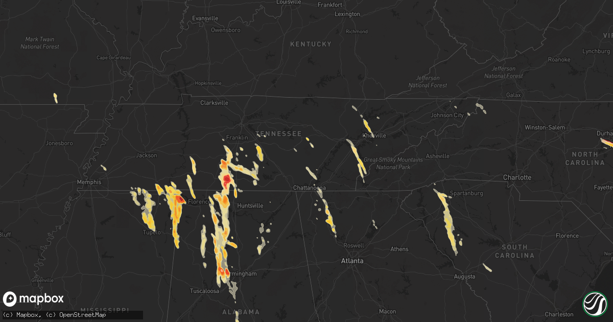
Hail Map in Alabama on March 31, 2012
Get this storm
March 31 map
$229
one time, instant access
Download today. No call, no setup
Keep the $229
Bought the map and want the full workflow? Apply the entire $229 to a subscription within 7 days. None of it is wasted.
Every map, not just this one
This buys you this map. Subscription and you get every map we run, in the markets you choose from a few cities to whole states to nationwide. Plus real-time alerts the moment a storm fires.
Contact data
Name, contact info, occupancy, even credit band for addresses in the footprint. You go from where it hit to who to call.
Become the source they trust
Unlimited branding weather history reports on demand. You already have the documented answer ready for the property owner, and you are the one who showed up with it.
Property data and RoofTrace estimates
Pull up any address you have got, its value and the exact code rules for that jurisdiction, straight from One Click Code. Then RoofTrace estimates the squares, pitch, and roof value, priced the way you price.
Storm reports in Alabama
Alabama
| Date | Description |
|---|---|
| 03/31/20126:59 PM CDT | Golf ball size hail covered the ground in parrish. |
| 03/31/20126:54 PM CDT | Tennis ball size hail was reported. |
| 03/31/20126:52 PM CDT | Quarter inch hail was reported at mile marker 362. |
| 03/31/20126:51 PM CDT | Reported by firefighter |
| 03/31/20126:49 PM CDT | Golf ball size hail was reported. |
| 03/31/20126:45 PM CDT | Golf ball size hail reported in the nesmith community in eastern winston county. |
| 03/31/20126:45 PM CDT | Quarter sized hail was reported in holland gin at 29859 old scrouge road. The hail produced damage to vehicles at the residence. Based on radar...the hail likely occurr |
| 03/31/20126:40 PM CDT | Quarter sized hail was reported in holland gin at 29859 old scrouge road. The hail produced damage to vehicles at the residence. Based on radar...the hail likely occurr |
| 03/31/20126:32 PM CDT | Golf ball size hail was reported on cr 59 approximately 3 miles sw of moulton. |
| 03/31/20126:31 PM CDT | Golf ball was reported. |
| 03/31/20126:30 PM CDT | Dime to quarter sized hail reported south of moulton. |
| 03/31/20126:29 PM CDT | Quarter sized hail on county road 39. Corrected. |
| 03/31/20126:29 PM CDT | Quarter sized hail on county road 39. |
| 03/31/20126:27 PM CDT | Half dollar size hail was reported at the moulton eoc. |
| 03/31/20126:25 PM CDT | Golf ball sized hail was reported. |
| 03/31/20126:24 PM CDT | Softball size hail was reported at tva campground in the riverton area. |
| 03/31/20126:16 PM CDT | Quarter size hail was reported at the intersection of freeman road. |
| 03/31/20126:15 PM CDT | Trees and power lines were reported down. |
| 03/31/20126:10 PM CDT | Quarter sized hail in altoona. |
| 03/31/20126:10 PM CDT | Estimated 60 to 70 mph winds just west of sispey near u.s. Highway 78. |
| 03/31/20126:10 PM CDT | Hail slightly larger than golfballs just west of sipsey near u.s. Highway 78. |
| 03/31/20126:04 PM CDT | Trees and power lines were reported down. |
| 03/31/20126:04 PM CDT | Golf ball size hail was reported. |
| 03/31/20126:04 PM CDT | Quarter size hail was reported in speake. |
| 03/31/20126:03 PM CDT | Quarter size hail was reported. |
| 03/31/20125:59 PM CDT | Golf ball sized hail in manchester. Up to 40 cars suffered damage to windows and sunroofs from the hail along curry highway. In addition several roofs sustained damage |
| 03/31/20125:59 PM CDT | Trees and powerlines were blown down. Winds were estimated to be between 50 and 60 mph. |
| 03/31/20125:58 PM CDT | A local report indicates 2.00 inch wind near SIPSEY |
| 03/31/20125:54 PM CDT | Quarter size hail was reported. |
| 03/31/20125:42 PM CDT | A local report indicates 1.00 inch wind near TRINITY |
| 03/31/20125:40 PM CDT | A tree was knocked across the road at the intersection of county roads 317 and 434. Time estimated by radar. |
| 03/31/20125:39 PM CDT | A barn was destroyed. |
| 03/31/20125:39 PM CDT | Half dollar size hail reported 5 miles south of ardmore. |
| 03/31/20125:39 PM CDT | Quarter sized hail was reported at the intersection of new cut road and highway 72. |
| 03/31/20125:35 PM CDT | Two 3 to 4 foot in diameter trees blown down. No injuries or roads blocked. |
| 03/31/20125:33 PM CDT | Golfball size hail was reported. |
| 03/31/20125:28 PM CDT | Quarter size hail was reported in arab. |
| 03/31/20125:28 PM CDT | Quarter sized hail was reported at browns ferry nuclear power plant. |
| 03/31/20125:15 PM CDT | Quarter size hail was reported in arab. |
| 03/31/20125:13 PM CDT | Half dollar size hail reported in curry. |
| 03/31/20125:11 PM CDT | Golf ball size hail reported at the corinth recreation area causing damage to vehicles. |
| 03/31/20125:07 PM CDT | Half dollar size hail was reported. |
| 03/31/20125:05 PM CDT | Tennis ball size hail was reported. |
| 03/31/20124:59 PM CDT | Nickel to quarter size hail was reported. |
| 03/31/20124:57 PM CDT | Golfball size hail was reported. |
| 03/31/20124:56 PM CDT | Quarter size hail was reported. |
| 03/31/20124:55 PM CDT | Hail from quarter to hen egg size was reported covering the ground. |
| 03/31/20124:53 PM CDT | Golfball size hail was reported. |
| 03/31/20124:52 PM CDT | Nickel to quarter size hail was reported. |
| 03/31/20124:52 PM CDT | Golfball size reported. |
| 03/31/20124:51 PM CDT | Golfball size hail was reported. |
| 03/31/20124:50 PM CDT | Golfball size hail was reported. |
| 03/31/20124:48 PM CDT | Quarter to half dollar size hail reported. |
| 03/31/20124:41 PM CDT | Quarter sized hail covering the ground on county road 89 between county roads 50 and 88 in the whitehead community. |
| 03/31/20124:39 PM CDT | Quarter size hail was reported. |
| 03/31/20124:23 PM CDT | Golfball size hail was reported on highway 99 just south of lester. |
| 03/31/20124:15 PM CDT | Quarter size hail was reported. |
| 03/30/201211:05 PM CDT | Storm chaser reported ping pong ball size hail along highway 17 northeast of detroit. |
| 03/30/201210:25 PM CDT | Storm chaser reported golf ball hail falling near the state line on u.s. Highway 78. |
| 03/30/20129:30 PM CDT | Quarter sized hail was reported. |
| 03/30/20129:05 PM CDT | Half dollar size hail in bull city on groundhog rd. |
| 03/30/20128:55 PM CDT | A local report indicates 1.00 inch wind near MONTEVALLO |
| 03/30/20128:46 PM CDT | Half dollar size hail near bankhead lake on smith camp rd. |
| 03/30/20128:29 PM CDT | Quarter size hail reported at the natural bridge restaurant. Corrected for time and location based on radar. |
| 03/30/20128:23 PM CDT | Quarter size hail reported at the natural bridge restaurant. Time estimated from radar. |
| 03/30/20128:03 PM CDT | Tree down on hwy 511 near rockhouse road. Estimated wind speed 40 mph. |
| 03/30/20128:03 PM CDT | Half dollar sized hail covering the ground in oak grove. |
| 03/30/20128:03 PM CDT | Quarter size hail near oak grove. |
| 03/30/20127:56 PM CDT | Quarter size hail covering the ground in oak grove. |
| 03/30/20127:55 PM CDT | Quarter size hail covering the ground in oak grove. |
| 03/30/20127:39 PM CDT | Golf ball hail reported just west of birmingport. |
| 03/30/20127:37 PM CDT | Hail up to the size of golfballs was observed for a second time near curry or 6 miles north of jasper on curry highway. This report was from the second storm that moved |
| 03/30/20127:31 PM CDT | 3 inch hail covering the ground reported at bluff creek on the warrior river at the jefferson/walker county line. Tree debris was also reported on the ground due to the |
| 03/30/20127:30 PM CDT | Quarter size hail reported just to the east of birmingport. |
| 03/30/20127:14 PM CDT | A few trees and power lines down. |
| 03/30/20127:14 PM CDT | Golf ball size hail reported in birmingport |
| 03/30/20127:07 PM CDT | 3 inch hail reported at bluff creek on the warrior river. |
| 03/30/20127:03 PM CDT | Quarter size hail covering the ground in parrish...hail was still falling. |
| 03/30/20127:02 PM CDT | Golf ball size hail reported in the community of helicon. The large hail damaged several vehicles in the area. Time estimated from radar. |
| 03/30/20127:00 PM CDT | Minor shingle damage to a home on county road 146. Large antenna attached to roof was also blown over. |
All States Impacted by Hail Map on March 31, 2012
Cities Impacted by Hail Map on March 31, 2012
- Princeville, IL
- Jacksonville, FL
- Oneonta, AL
- Altoona, AL
- Mulga, AL
- Parrish, AL
- Quinton, AL
- Bessemer, AL
- Adger, AL
- Oakman, AL
- Pulaski, TN
- Sulligent, AL
- Detroit, AL
- Calhoun, GA
- Woodhull, IL
- Williamsfield, IL
- Wataga, IL
- New Windsor, IL
- Joy, IL
- Mapleton, IL
- Hanna City, IL
- Dahinda, IL
- Reynolds, IL
- Pekin, IL
- Edwards, IL
- Speer, IL
- East Peoria, IL
- Bloomington, IL
- Morton, IL
- Altona, IL
- Dunlap, IL
- Deer Creek, IL
- Sherrard, IL
- Galesburg, IL
- Taylor Ridge, IL
- Mossville, IL
- Rio, IL
- Brimfield, IL
- Creve Coeur, IL
- Groveland, IL
- Metamora, IL
- Knoxville, IL
- Victoria, IL
- Oneida, IL
- Eureka, IL
- Alexis, IL
- Glasford, IL
- Illinois City, IL
- North Henderson, IL
- Viola, IL
- Tremont, IL
- Washington, IL
- Matherville, IL
- Peoria, IL
- Laura, IL
- Edelstein, IL
- Aledo, IL
- Alpha, IL
- Chillicothe, IL
- Trivoli, IL
- Danvers, IL
- Goodfield, IL
- Toulon, IL
- Mackinaw, IL
- Mechanicsville, IA
- Clarence, IA
- Olin, IA
- Stanwood, IA
- Atoka, TN
- Dalton, GA
- Gratiot, WI
- South Wayne, WI
- Elizabeth, IL
- Scales Mound, IL
- Saint Augustine, FL
- Ponte Vedra Beach, FL
- Ponte Vedra, FL
- Waynesboro, TN
- Clifton, TN
- Linden, TN
- Greenville, SC
- Primm Springs, TN
- Franklin, TN
- Creston, NC
- Warrensville, NC
- Logan, AL
- Vinemont, AL
- Addison, AL
- Hartselle, AL
- Trinity, AL
- Danville, AL
- Decatur, AL
- Moulton, AL
- Arley, AL
- Cullman, AL
- Falkville, AL
- Houston, AL
- Easley, SC
- Resaca, GA
- Chatsworth, GA
- Crane Hill, AL
- Hanceville, AL
- Bremen, AL
- Wheatland, IA
- Lisbon, IA
- Martelle, IA
- Lowden, IA
- Bennett, IA
- New Liberty, IA
- Dixon, IA
- Springville, IA
- Mount Vernon, IA
- Wartrace, TN
- Salley, SC
- Wagener, SC
- Stanford, IL
- Orange Park, FL
- Waterloo, AL
- Rienzi, MS
- Booneville, MS
- Dumas, MS
- Walnut, MS
- Tiplersville, MS
- Corinth, MS
- Ripley, MS
- Plantersville, AL
- Brookwood, AL
- Ardmore, TN
- Leoma, TN
- Anderson, AL
- Culleoka, TN
- Athens, AL
- Minor Hill, TN
- Prospect, TN
- Cornersville, TN
- Summertown, TN
- Ethridge, TN
- Petersburg, TN
- Lawrenceburg, TN
- Rogersville, AL
- Santa Fe, TN
- Lewisburg, TN
- Columbia, TN
- Jasper, AL
- Lynnville, TN
- Cordova, AL
- Northport, AL
- Town Creek, AL
- Lexington, AL
- Goodspring, TN
- Lester, AL
- Mount Pleasant, TN
- Tanner, AL
- Double Springs, AL
- Hillsboro, AL
- Belfast, TN
- Elkmont, AL
- Maryville, TN
- Dahlonega, GA
- Murrayville, GA
- Pioneer, TN
- Oneida, TN
- Sparta, TN
- Tellico Plains, TN
- Rocky Top, TN
- Belton, SC
- Pelzer, SC
- Donalds, SC
- Bradley, SC
- Fountain Inn, SC
- Piedmont, SC
- Troy, SC
- Greenwood, SC
- Simpsonville, SC
- McCormick, SC
- Hodges, SC
- Ware Shoals, SC
- Honea Path, SC
- Abbeville, SC
- Travelers Rest, SC
- Taylors, SC
- Due West, SC
- Bronson, FL
- Baldwyn, MS
- Tupelo, MS
- Blue Springs, MS
- Guntown, MS
- Saltillo, MS
- Lynn, AL
- Carbon Hill, AL
- Haleyville, AL
- Eldridge, AL
- Nauvoo, AL
- Kingston, TN
- Kent, IL
- Stockton, IL
- Pearl City, IL
- Lena, IL
- Durham, NC
- Morrisville, NC
- Raleigh, NC
- Apex, NC
- Garner, NC
- Cary, NC
- Killen, AL
- Glade Spring, VA
- Damascus, VA
- Meadowview, VA
- Ardmore, AL
- Soddy Daisy, TN
- Dunlap, TN
- Burnsville, MS
- Glen, MS
- Tishomingo, MS
- Iuka, MS
- Olivehill, TN
- Collinwood, TN
- Saint Johns, FL
- Fleming Island, FL
- Green Cove Springs, FL
- Savannah, TN
- Powell, TN
- Heiskell, TN
- Maynard, AR
- Hixson, TN
- Counce, TN
- Michie, TN
- Lutts, TN
- Spencer, TN
- Pikeville, TN
- Crossville, TN
- Sulphur Bluff, TX
- Lake Creek, TX
- Florence, AL
- Cypress Inn, TN
- Palm Coast, FL
- Jacksboro, TN
- Caryville, TN
- Lake City, FL
- Fort White, FL
- Rock Island, IL
- Freeport, IL
- Russellville, AL
- Chapel Hill, TN
- Spring Hill, TN
- College Grove, TN
- Berry, AL
- Ramer, TN
- Guys, TN
- Murfreesboro, TN
- Christiana, TN
- Arlington, TN
- Brighton, TN
- Millington, TN
- Knoxville, TN
- Coal Valley, IL
- Milan, IL
- Moline, IL
- Montevallo, AL
- Helena, AL
- Cherokee, AL
- Maplesville, AL
- Stanton, AL
- Jones, AL
- Belmont, MS
- Golden, MS
- Dennis, MS
- Red Bay, AL
- Empire, AL
- Mulberry, TN
- Fayetteville, TN
- Bryceville, FL
- Titusville, FL
- Vonore, TN
- Palatka, FL
- Elkton, FL
- Monticello, IA
- Fulton, MS
- Hamilton, AL
- Tremont, MS
- Vina, AL
- Greenwood Springs, MS
- Doniphan, MO
- Albertville, AL
- Shelbyville, TN
- Clayton, NC
- Plum Branch, SC
- Norris, TN
- Clinton, TN
- Andersonville, TN
- Ninety Six, SC
- Ashland, MS
- Falkner, MS
- Fairmount, GA
- Rydal, GA
- Adairsville, GA
- Brierfield, AL
- Randolph, AL
- White, GA
- La Fayette, GA
- Rock Spring, GA
- Bell Buckle, TN
- Michigan City, MS
- Guntersville, AL
- Horton, AL
- Oxford Junction, IA
- Marietta, SC
- Pickens, SC
- Armuchee, GA
- Dyersville, IA
- Farley, IA
- Worthington, IA
- Todd, NC
- Fleetwood, NC
- West Jefferson, NC
- Sumner, TX
- New Albany, MS
- Newberry, FL
- Cambridge, IL
- Lynn Center, IL
- Bernard, IA
- Zwingle, IA
- Courtland, AL
- Cedar Rapids, IA
- Hiawatha, IA
- Madisonville, TN
- Keystone Heights, FL
- Philadelphia, TN
- Loudon, TN
- Sweetwater, TN
- Blue Grass, IA
- Davenport, IA
- Galena, IL
- Selmer, TN
- Woodville, AL
- Honey Grove, TX
- Petty, TX
- Roxton, TX
- Chattanooga, TN
- Aiken, SC
- Middleton, TN
- Saulsbury, TN
- Blue Mountain, MS
- Mooreville, MS
- Dora, AL
- Leighton, AL
- West Blocton, AL
- McCalla, AL
- Alabaster, AL
- Lynchburg, TN
- Kelso, TN
- Vance, AL
- Adamsville, AL
- Birmingham, AL
- Canton, TX
- Cooper, TX
- Paris, TX
- Cartersville, GA
- Murphy, NC
- Florahome, FL
- Graysville, TN
- Edgefield, SC
- Modoc, SC
- Ryan, IA
- Chapel Hill, NC
- Lake Butler, FL
- Bluff City, TN
- Orangeville, IL
- Monroe, WI
- Tunnel Hill, GA
- Lost Nation, IA
- Orlando, FL
- Smithfield, NC
- Cleveland, SC
- Lascassas, TN
- Donahue, IA
- Anamosa, IA
- Marion, IA
- Calamus, IA
- Gainesville, GA
- Chiefland, FL
- Ooltewah, TN
- Ringgold, GA
- Apison, TN
- Graysville, AL
- Baldwin, IA
- Maquoketa, IA
- Monmouth, IA
- Central City, IA
- Palo, IA
- Sale Creek, TN
- Shellsburg, IA
- Atkins, IA
- Bristol, TN
- Cascade, IA
- Onslow, IA
- Eldridge, IA
- Long Grove, IA
- Hampton, FL
- Starke, FL
- Waldo, FL
- Hugo, OK
- Earleton, FL
- Melrose, FL
- Gadsden, AL
- Gainesville, FL
- Grand Junction, TN
- Bunnell, FL
- Wyoming, IA
- Boaz, AL
- Summerville, GA
- Vinton, IA
- Peosta, IA
- Clutier, IA
- Hopedale, IL
- Minier, IL
- Maynardville, TN
- Satsuma, FL
- Greer, SC
- Mountain City, TN
- Chester, VA
- Chesterfield, VA
- Alachua, FL
- Butler, TN
- Vilas, NC
- Springville, AL
- Batesburg, SC
- Harriman, TN
- Lenoir City, TN
- High Springs, FL
- Powderly, TX
- Rock Island, TN
- Toddville, IA
- Dysart, IA
- Garrison, IA
- San Mateo, FL
- Mineral Point, WI
- Phil Campbell, AL
- Flagler Beach, FL
- Orion, IL
- Lamont, FL
- Monticello, FL


