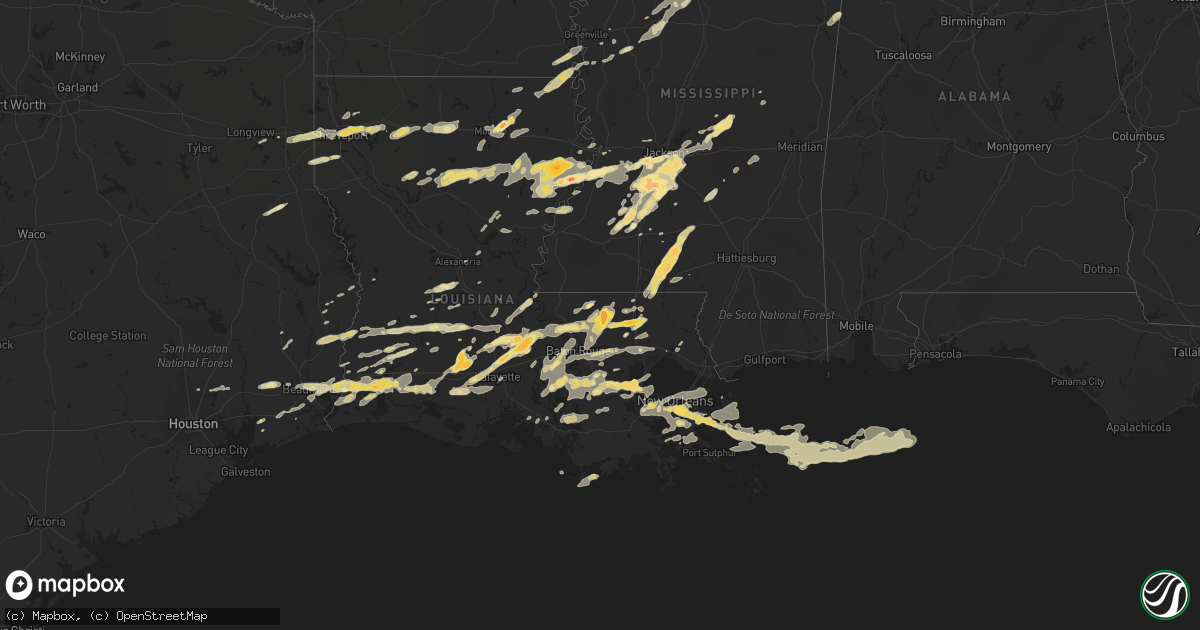
Hail Map in Mississippi on March 29, 2011
Get this storm
March 29 map
$229
one time, instant access
Download today. No call, no setup
Keep the $229
Bought the map and want the full workflow? Apply the entire $229 to a subscription within 7 days. None of it is wasted.
Every map, not just this one
This buys you this map. Subscription and you get every map we run, in the markets you choose from a few cities to whole states to nationwide. Plus real-time alerts the moment a storm fires.
Contact data
Name, contact info, occupancy, even credit band for addresses in the footprint. You go from where it hit to who to call.
Become the source they trust
Unlimited branding weather history reports on demand. You already have the documented answer ready for the property owner, and you are the one who showed up with it.
Property data and RoofTrace estimates
Pull up any address you have got, its value and the exact code rules for that jurisdiction, straight from One Click Code. Then RoofTrace estimates the squares, pitch, and roof value, priced the way you price.
Storm reports in Mississippi
Mississippi
| Date | Description |
|---|---|
| 03/29/20116:50 PM CDT | A local report indicates 1.75 inch wind near 12 SW HAZLEHURST |
| 03/29/20116:48 PM CDT | Lemon to hen egg size hail reported south of jayess or just east of enon near highway 583. |
| 03/29/20116:41 PM CDT | Walthall county emergency manager reported golf ball sized hail in the dinan community. |
| 03/29/20116:37 PM CDT | Hail ranged from pea to quarter size |
| 03/29/20116:20 PM CDT | A local report indicates 1.00 inch wind near 8 SE MAGNOLIA |
| 03/29/20116:20 PM CDT | A local report indicates 1.00 inch wind near 8 E MAGNOLIA |
| 03/29/201112:41 PM CDT | Quarter to golf ball hail accumulated 4 inches deep with other areas having hail gathered up to 1 ft deep. This hail stripped the leaves from trees and caused damage to |
| 03/29/201110:13 AM CDT | A local report indicates 1.00 inch wind near STEENS |
| 03/29/20118:40 AM CDT | Along raymond rd |
| 03/29/20117:40 AM CDT | A local report indicates 1.75 inch wind near TERRY |
| 03/28/201110:45 PM CDT | A local report indicates 1.50 inch wind near TULA |
| 03/28/201110:36 PM CDT | Nickel to quarter sized hail across the southern sections of itawamba county |
| 03/28/201110:24 PM CDT | Nickel to quarter sized hail south of water valley |
| 03/28/201110:13 PM CDT | A local report indicates 1.00 inch wind near STEENS |
| 03/28/201110:01 PM CDT | Hail up to a quarter inch covering ground |
| 03/28/201110:00 PM CDT | Fell along us 51 near geeslin corner |
| 03/28/20119:50 PM CDT | A local report indicates 1.00 inch wind near 5 W GRENADA |
| 03/28/20119:41 PM CDT | Quarter to golf ball hail accumulated 4 inches deep with other areas having hail gathered up to 1 ft deep. This hail stripped the leaves from trees and caused damage to |
| 03/28/20119:40 PM CDT | A macroburst occurred in ne simpson co along old pearl rd...crisco rd and lewis rd. Numerous hardwood and softwood trees were uprooted and snapped. Several trees were o |
| 03/28/20119:30 PM CDT | Golfball hail reported as being 4 inches deep in the old pearl community. |
| 03/28/20119:30 PM CDT | Trees down in the city |
| 03/28/20119:30 PM CDT | Several roofs off homes and barns along old pearl road and old pearl community. Several large trees and powerlines down. |
| 03/28/20119:25 PM CDT | A metal building was damaged with the walls blown out. |
| 03/28/20119:25 PM CDT | A local report indicates 1.00 inch wind near PHILADELPHIA |
| 03/28/20119:24 PM CDT | A mobile home was pushed off its foundation and a barn was nearly destroyed. Numerous trees were down along with several power poles. |
| 03/28/20119:24 PM CDT | Also 40 mph winds reported |
| 03/28/20119:23 PM CDT | Numerous trees were uprooted and snapped around town. Several trees fell on homes causing structural damage. |
| 03/28/20119:23 PM CDT | Tennis ball sized hail reported along county line rd. |
| 03/28/20119:20 PM CDT | Police scanners indicate lots of trees down blocking several roads in the city...relayed by amateur radio...update...numerous large trees snapped and uprooted...power p |
| 03/28/20119:18 PM CDT | Trees were downed across i-55 between terry and crystal springs |
| 03/28/20119:16 PM CDT | A local report indicates 1.00 inch wind near GREENWOOD |
| 03/28/20119:15 PM CDT | Trees downed across the road at old highway 51 and sawmill rd. Numerous trees downed across southern hinds county near terry. |
| 03/28/20119:10 PM CDT | A tree fell on the edinburg attendance center |
| 03/28/20119:10 PM CDT | Trees were blown down across the road near the intersection of midway rd and haley rd. |
| 03/28/20119:07 PM CDT | A local report indicates 1.00 inch wind near PINEVILLE |
| 03/28/20119:00 PM CDT | Reported as 5 southwest of jackson airport |
| 03/28/20119:00 PM CDT | Tree down blocking old brandon road at el dorado road |
| 03/28/20118:50 PM CDT | A local report indicates 1.00 inch wind near WALNUT GROVE |
| 03/28/20118:50 PM CDT | Several large trees were downed along woody dr |
| 03/28/20118:43 PM CDT | A local report indicates 1.50 inch wind near WALNUT GROVE |
| 03/28/20118:40 PM CDT | Along raymond rd |
| 03/28/20118:38 PM CDT | A few trees down in raymond |
| 03/28/20118:33 PM CDT | A local report indicates 1.00 inch wind near 2 E LEARNED |
| 03/28/20118:29 PM CDT | A local report indicates 1.50 inch wind near 5 WNW HARPERVILLE |
| 03/28/20118:29 PM CDT | Lots of trees down in learned. |
| 03/28/20118:24 PM CDT | Report 2 miles north of county line and 1 mile east of highway 49w |
| 03/28/20118:20 PM CDT | Hail reported to be covering the ground |
| 03/28/20118:15 PM CDT | A local report indicates 1.00 inch wind near BRANDON |
| 03/28/20118:15 PM CDT | Hail a little larger than quarters along gatesville road in gatesville |
| 03/28/20118:15 PM CDT | Penny size hail was also falling |
| 03/28/20118:10 PM CDT | Golfball size hail reported around the intersection of ms highway 468 and ms highway 469 |
| 03/28/20118:07 PM CDT | Several trees down along sandy yarn and brushy creek rds. |
| 03/28/20118:06 PM CDT | A little larger than hen egg sized hail occurred along bailey rd...2.25 inch |
| 03/28/20118:05 PM CDT | A local report indicates 1.00 inch wind near PEARL |
| 03/28/20117:55 PM CDT | Quarter to golf ball size hail reported to emergency manager by florence police dept |
| 03/28/20117:53 PM CDT | Quarter size hail covered the ground lightly. |
| 03/28/20117:52 PM CDT | Hail ranging in size from pea to quarter |
| 03/28/20117:45 PM CDT | Quarter size hail covering the ground. |
| 03/28/20117:40 PM CDT | A local report indicates 1.75 inch wind near TERRY |
| 03/28/20117:40 PM CDT | A few trees down with one on a mobile home that damaged the roof. |
| 03/28/20117:40 PM CDT | A local report indicates 1.75 inch wind near 1 S TERRY |
| 03/28/20117:30 PM CDT | Reported south of vicksburg along the warren and claiborne county line |
| 03/28/20117:25 PM CDT | A local report indicates 1.75 inch wind near CRYSTAL SPRINGS |
| 03/28/20117:02 PM CDT | A local report indicates 1.75 inch wind near 6 E JAYESS |
All States Impacted by Hail Map on March 29, 2011
Cities Impacted by Hail Map on March 29, 2011
- Clinton, AR
- Shirley, AR
- Hammond, LA
- Ponchatoula, LA
- Nettleton, MS
- Maurepas, LA
- Harrisville, MS
- Jasper, TX
- Tanner, AL
- Athens, AL
- Franklin, LA
- Newellton, LA
- Boutte, LA
- Paradis, LA
- Cherokee, AL
- Tuscumbia, AL
- Florence, AL
- Cabot, AR
- North Little Rock, AR
- Jacksonville, AR
- Sherwood, AR
- Dequincy, LA
- Ragley, LA
- Port Gibson, MS
- Choudrant, LA
- Ruston, LA
- Grambling, LA
- Simsboro, LA
- Eagle Pass, TX
- Marshall, TX
- Shreveport, LA
- Greenwood, LA
- Waskom, TX
- Rayne, LA
- Crowley, LA
- Doyline, LA
- Port Allen, LA
- Keithville, LA
- Stonewall, LA
- Gibsland, LA
- Oberlin, LA
- Timpson, TX
- Garrison, TX
- Rocksprings, TX
- Duson, LA
- Denham Springs, LA
- Magnolia, MS
- Mccomb, MS
- Amite, LA
- Independence, LA
- Fordoche, LA
- Krotz Springs, LA
- Lottie, LA
- Westwego, LA
- Eudora, AR
- Oak Grove, LA
- Jones, LA
- Forest, MS
- Walnut Grove, MS
- Lena, MS
- Morton, MS
- Ardmore, AL
- Elkmont, AL
- Ardmore, TN
- Toney, AL
- Opelousas, LA
- Port Barre, LA
- Little Rock, AR
- Hensley, AR
- Glynn, LA
- Zachary, LA
- Slaughter, LA
- Jarreau, LA
- Leesville, LA
- Courtland, AL
- Town Creek, AL
- Taft, TN
- Rogersville, AL
- Hillsboro, AL
- Clinton, LA
- Plaquemine, LA
- Del Rio, TX
- Brackettville, TX
- Maumelle, AR
- Greensburg, LA
- Pine Grove, LA
- Greenwell Springs, LA
- Miami, FL
- Okeechobee, FL
- Belle Glade, FL
- Canal Point, FL
- Pahokee, FL
- Monroe, LA
- Monticello, MS
- Jayess, MS
- Tylertown, MS
- Terry, MS
- Geismar, LA
- Donaldsonville, LA
- Saint Martinville, LA
- White Castle, LA
- Gonzales, LA
- Darrow, LA
- Crystal Springs, MS
- Holden, LA
- Roseland, LA
- Loranger, LA
- Hazlehurst, MS
- Union Church, MS
- Brookhaven, MS
- Wesson, MS
- La Place, LA
- Reserve, LA
- Garyville, LA
- Lake Village, AR
- Gueydan, LA
- Kaplan, LA
- Morse, LA
- Raymond, MS
- Dodson, LA
- Sikes, LA
- Foxworth, MS
- Oak Vale, MS
- Livingston, LA
- Madison, AL
- Millport, AL
- Steens, MS
- Loxahatchee, FL
- Vicksburg, MS
- Barksdale Afb, LA
- Haughton, LA
- Bossier City, LA
- Braithwaite, LA
- Belle Chasse, LA
- Gretna, LA
- Harvey, LA
- New Orleans, LA
- Longview, TX
- Hallsville, TX
- Mendenhall, MS
- Mize, MS
- Magee, MS
- Raleigh, MS
- Arcadia, LA
- Glenmora, LA
- Forest Hill, LA
- Grosse Tete, LA
- Newport, AR
- Oil Trough, AR
- Rosie, AR
- Magness, AR
- Newark, AR
- Bee Branch, AR
- Gilbert, LA
- Utica, MS
- Branch, LA
- Egan, LA
- Eunice, LA
- Iota, LA
- Carencro, LA
- Maringouin, LA
- Arnaudville, LA
- Breaux Bridge, LA
- Florence, MS
- Georgetown, MS
- Orange, TX
- Starks, LA
- Kentwood, LA
- Amory, MS
- Fulton, MS
- Smithville, MS
- Sherwood, TN
- Clinton, MS
- Bolton, MS
- Benton, LA
- Destrehan, LA
- Luling, LA
- Saint Rose, LA
- Ama, LA
- Carthage, MS
- Bruce, MS
- Randolph, MS
- Sulphur, LA
- Winnsboro, LA
- Lacassine, LA
- Bell City, LA
- Trenton, TN
- Richland, MS
- Pearl, MS
- Brandon, MS
- Saint Bernard, LA
- Marrero, LA
- Vidalia, GA
- Lyons, GA
- Tuckerman, AR
- Greenville, MS
- Mer Rouge, LA
- Hollandale, MS
- Chatham, MS
- Saint Joseph, LA
- Delhi, LA
- Tallulah, LA
- Lettsworth, LA
- Batchelor, LA
- Okolona, MS
- Shannon, MS
- Baskin, LA
- Metter, GA
- Byram, MS
- Jackson, MS
- Iowa, LA
- Lake Arthur, LA
- Prentiss, MS
- Osyka, MS
- Kokomo, MS
- Silver Creek, MS
- Saint James, LA
- Sour Lake, TX
- Hull, TX
- Devers, TX
- Melville, LA
- Estill Springs, TN
- Decherd, TN
- Belvidere, TN
- Flintville, TN
- Mulberry, TN
- Kelso, TN
- Winchester, TN
- Elton, LA
- Newton, TX
- Mangham, LA
- Prairieville, LA
- Paron, AR
- Itta Bena, MS
- Sidon, MS
- Greenwood, MS
- Columbia, LA
- Grayson, LA
- Morgan City, LA
- Pierre Part, LA
- Napoleonville, LA
- Drasco, AR
- Tremont, MS
- Goldonna, LA
- Saline, LA
- Pineville, LA
- Hessmer, LA
- Marksville, LA
- Collinston, LA
- Hackberry, LA
- Pitkin, LA
- Jena, LA
- Kinder, LA
- Lake Charles, LA
- McCall Creek, MS
- Braxton, MS
- Hillsboro, TN
- Harvest, AL
- Hazel Green, AL
- Fayetteville, TN
- Leighton, AL
- Water Valley, MS
- Banner, MS
- Oxford, MS
- Paris, MS
- Aberdeen, MS
- Mount Hermon, LA
- Mamou, LA
- Ville Platte, LA
- Mittie, LA
- Oakdale, LA
- Holcomb, MS
- Carrollton, MS
- Covington, LA
- Abita Springs, LA
- Dry Creek, LA
- Longville, LA
- Trout, LA
- Isola, MS
- Anahuac, TX
- Call, TX
- Kirbyville, TX
- Merryville, LA
- Buna, TX
- Beaumont, TX
- Cameron, LA
- Vinton, LA
- Vidor, TX
- Hot Springs Village, AR
- Hot Springs National Park, AR
- Warren, TX
- Kountze, TX
- Leland, MS
- El Indio, TX
- Natchez, MS
- Baton Rouge, LA
- Mabelvale, AR
- Coffeeville, MS
- Dubberly, LA
- Carrizo Springs, TX
- Chalmette, LA
- Violet, LA
- Meraux, LA
- Kenner, LA
- Lafitte, LA
- Metairie, LA
- Barataria, LA
- Des Allemands, LA
- Pride, LA
- Columbus, MS
- Theriot, LA
- Huntsville, AL
- Ochopee, FL
- Ethelsville, AL
- Lafayette, LA
- Bogue Chitto, MS
- Minden, LA
- Winnie, TX
- Sicily Island, LA
- Clayton, LA
- Lorman, MS
- Keatchie, LA
- De Berry, TX
- Cascilla, MS
- Grenada, MS
- Benton, AR
- Port Sulphur, LA
- Ventress, LA
- Princeton, LA
- Sibley, LA
- Scobey, MS
- Tillatoba, MS
- Red Bay, AL
- Sugartown, LA
- Grant, LA
- Morganza, LA
- Washington, LA
- Rougon, LA
- Youngsville, LA
- Oscar, LA
- Scott, LA
- Jackson, LA
- Ethel, LA
- Walker, LA
- Sunset, LA
- Erwinville, LA
- Livonia, LA
- New Roads, LA
- Lakeland, LA
- Church Point, LA
- Maurice, LA
- Bon Wier, TX
- Deridder, LA
- Jennings, LA
- Philadelphia, MS
- Porter, TX
- Palmetto, LA
- Saint Francisville, LA
- Plaucheville, LA
- Huntland, TN
- Elora, TN
- Jonesboro, AR
- Estillfork, AL
- Winnfield, LA
- Pleasant Plains, AR
- Batesville, AR
- Westlake, LA
- Quitman, AR
- Saint Amant, LA
- Gramercy, LA
- Convent, LA
- Paulina, LA
- Sorrento, LA
- Belle Rose, LA
- Brusly, LA
- Wiergate, TX
- Floral, AR
- Tumbling Shoals, AR
- Ida, AR
- Concord, AR
- Welsh, LA
- Jonesville, LA
- Edgard, LA
- Albany, LA
- Springfield, LA
- Lutcher, LA
- Plattenville, LA
- Addis, LA
- Norco, LA
- Carville, LA
- Jeanerette, LA
- Bauxite, AR
- Alexander, AR
- Roland, AR
- Scott, AR
- New Market, AL
- Lonsdale, AR
- West Monroe, LA
- Bridge City, TX
- Evangeline, LA
- Nederland, TX
- Reeves, LA
- Clewiston, FL
- Thibodaux, LA
- Guin, AL
- Hamilton, AL
- Deville, LA
- Rayville, LA
- Oak Ridge, LA
- Hermanville, MS
- Waterproof, LA
- Ferriday, LA
- Bunkie, LA
- Morrow, LA
- Hamshire, TX
- Kingwood, TX
- Huffman, TX
- Dayton, TX
- Burkeville, TX
- McKenzie, TN
- Flowood, MS
- Edwards, MS
- Swifton, AR
- Pinola, MS
- England, AR
- Louin, MS
- Newton, MS
- Lawrence, MS
- Twin City, GA
- Angola, LA
- Whitwell, TN
- Indianola, MS
- Decatur, AL
- Somerville, AL
- Pelahatchie, MS
- Bastrop, LA
- Avon Park, FL
- Waldron, AR
- Nacogdoches, TX
- Mansfield, LA
- Broussard, LA
- Schlater, MS
- Malvern, AR
- Lecompte, LA
- Woodworth, LA
- Singer, LA
- Jonesboro, LA
- Olla, LA
- Cottonport, LA
- Russellville, AR
- Booneville, AR
- Enterprise, LA
- Homestead, FL
- Tickfaw, LA
- Mandeville, LA
- Bradford, TN
- Milan, TN
- Cohutta, GA
- Fluker, LA
- Pelham, TN
- Beaverton, AL
- Hahnville, LA
- Fort Necessity, LA
- Wisner, LA
- Chatham, LA


