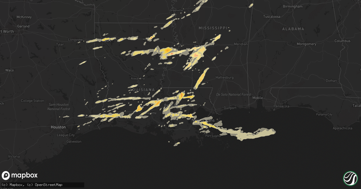
Hail Map in Alabama on March 29, 2011
Get this storm
March 29 map
$229
one time, instant access
Download today. No call, no setup
Keep the $229
Bought the map and want the full workflow? Apply the entire $229 to a subscription within 7 days. None of it is wasted.
Every map, not just this one
This buys you this map. Subscription and you get every map we run, in the markets you choose from a few cities to whole states to nationwide. Plus real-time alerts the moment a storm fires.
Contact data
Name, contact info, occupancy, even credit band for addresses in the footprint. You go from where it hit to who to call.
Become the source they trust
Unlimited branding weather history reports on demand. You already have the documented answer ready for the property owner, and you are the one who showed up with it.
Property data and RoofTrace estimates
Pull up any address you have got, its value and the exact code rules for that jurisdiction, straight from One Click Code. Then RoofTrace estimates the squares, pitch, and roof value, priced the way you price.
Storm reports in Alabama
Alabama
| Date | Description |
|---|---|
| 03/29/20111:10 AM CDT | Dug hill road |
| 03/29/20111:00 AM CDT | Parkway and byrd springs road |
| 03/29/201112:50 AM CDT | A local report indicates 1.00 inch wind near FLORENCE |
| 03/28/201111:45 PM CDT | Quarter sized hail was reported in the oak grove-thatch community of elkmont. |
| 03/28/201111:45 PM CDT | Estimated hail size in the elkmont community. |
| 03/28/201111:44 PM CDT | Viewer measured 3 inch hail and passed report along to media. Damage to vehicle. |
| 03/28/201111:38 PM CDT | A local report indicates 1.00 inch wind near ELKMONT |
| 03/28/201111:35 PM CDT | Golf ball hail along interstate 65. |
| 03/28/201111:31 PM CDT | Quarter sized hail was reported at the intersection of highway 24 and 43. |
| 03/28/201110:32 PM CDT | A local report indicates 1.00 inch wind near 3 NNW MELBORNE |
All States Impacted by Hail Map on March 29, 2011
Cities Impacted by Hail Map on March 29, 2011
- Clinton, AR
- Shirley, AR
- Hammond, LA
- Ponchatoula, LA
- Nettleton, MS
- Maurepas, LA
- Harrisville, MS
- Jasper, TX
- Tanner, AL
- Athens, AL
- Franklin, LA
- Newellton, LA
- Boutte, LA
- Paradis, LA
- Cherokee, AL
- Tuscumbia, AL
- Florence, AL
- Cabot, AR
- North Little Rock, AR
- Jacksonville, AR
- Sherwood, AR
- Dequincy, LA
- Ragley, LA
- Port Gibson, MS
- Choudrant, LA
- Ruston, LA
- Grambling, LA
- Simsboro, LA
- Eagle Pass, TX
- Marshall, TX
- Shreveport, LA
- Greenwood, LA
- Waskom, TX
- Rayne, LA
- Crowley, LA
- Doyline, LA
- Port Allen, LA
- Keithville, LA
- Stonewall, LA
- Gibsland, LA
- Oberlin, LA
- Timpson, TX
- Garrison, TX
- Rocksprings, TX
- Duson, LA
- Denham Springs, LA
- Magnolia, MS
- Mccomb, MS
- Amite, LA
- Independence, LA
- Fordoche, LA
- Krotz Springs, LA
- Lottie, LA
- Westwego, LA
- Eudora, AR
- Oak Grove, LA
- Jones, LA
- Forest, MS
- Walnut Grove, MS
- Lena, MS
- Morton, MS
- Ardmore, AL
- Elkmont, AL
- Ardmore, TN
- Toney, AL
- Opelousas, LA
- Port Barre, LA
- Little Rock, AR
- Hensley, AR
- Glynn, LA
- Zachary, LA
- Slaughter, LA
- Jarreau, LA
- Leesville, LA
- Courtland, AL
- Town Creek, AL
- Taft, TN
- Rogersville, AL
- Hillsboro, AL
- Clinton, LA
- Plaquemine, LA
- Del Rio, TX
- Brackettville, TX
- Maumelle, AR
- Greensburg, LA
- Pine Grove, LA
- Greenwell Springs, LA
- Miami, FL
- Okeechobee, FL
- Belle Glade, FL
- Canal Point, FL
- Pahokee, FL
- Monroe, LA
- Monticello, MS
- Jayess, MS
- Tylertown, MS
- Terry, MS
- Geismar, LA
- Donaldsonville, LA
- Saint Martinville, LA
- White Castle, LA
- Gonzales, LA
- Darrow, LA
- Crystal Springs, MS
- Holden, LA
- Roseland, LA
- Loranger, LA
- Hazlehurst, MS
- Union Church, MS
- Brookhaven, MS
- Wesson, MS
- La Place, LA
- Reserve, LA
- Garyville, LA
- Lake Village, AR
- Gueydan, LA
- Kaplan, LA
- Morse, LA
- Raymond, MS
- Dodson, LA
- Sikes, LA
- Foxworth, MS
- Oak Vale, MS
- Livingston, LA
- Madison, AL
- Millport, AL
- Steens, MS
- Loxahatchee, FL
- Vicksburg, MS
- Barksdale Afb, LA
- Haughton, LA
- Bossier City, LA
- Braithwaite, LA
- Belle Chasse, LA
- Gretna, LA
- Harvey, LA
- New Orleans, LA
- Longview, TX
- Hallsville, TX
- Mendenhall, MS
- Mize, MS
- Magee, MS
- Raleigh, MS
- Arcadia, LA
- Glenmora, LA
- Forest Hill, LA
- Grosse Tete, LA
- Newport, AR
- Oil Trough, AR
- Rosie, AR
- Magness, AR
- Newark, AR
- Bee Branch, AR
- Gilbert, LA
- Utica, MS
- Branch, LA
- Egan, LA
- Eunice, LA
- Iota, LA
- Carencro, LA
- Maringouin, LA
- Arnaudville, LA
- Breaux Bridge, LA
- Florence, MS
- Georgetown, MS
- Orange, TX
- Starks, LA
- Kentwood, LA
- Amory, MS
- Fulton, MS
- Smithville, MS
- Sherwood, TN
- Clinton, MS
- Bolton, MS
- Benton, LA
- Destrehan, LA
- Luling, LA
- Saint Rose, LA
- Ama, LA
- Carthage, MS
- Bruce, MS
- Randolph, MS
- Sulphur, LA
- Winnsboro, LA
- Lacassine, LA
- Bell City, LA
- Trenton, TN
- Richland, MS
- Pearl, MS
- Brandon, MS
- Saint Bernard, LA
- Marrero, LA
- Vidalia, GA
- Lyons, GA
- Tuckerman, AR
- Greenville, MS
- Mer Rouge, LA
- Hollandale, MS
- Chatham, MS
- Saint Joseph, LA
- Delhi, LA
- Tallulah, LA
- Lettsworth, LA
- Batchelor, LA
- Okolona, MS
- Shannon, MS
- Baskin, LA
- Metter, GA
- Byram, MS
- Jackson, MS
- Iowa, LA
- Lake Arthur, LA
- Prentiss, MS
- Osyka, MS
- Kokomo, MS
- Silver Creek, MS
- Saint James, LA
- Sour Lake, TX
- Hull, TX
- Devers, TX
- Melville, LA
- Estill Springs, TN
- Decherd, TN
- Belvidere, TN
- Flintville, TN
- Mulberry, TN
- Kelso, TN
- Winchester, TN
- Elton, LA
- Newton, TX
- Mangham, LA
- Prairieville, LA
- Paron, AR
- Itta Bena, MS
- Sidon, MS
- Greenwood, MS
- Columbia, LA
- Grayson, LA
- Morgan City, LA
- Pierre Part, LA
- Napoleonville, LA
- Drasco, AR
- Tremont, MS
- Goldonna, LA
- Saline, LA
- Pineville, LA
- Hessmer, LA
- Marksville, LA
- Collinston, LA
- Hackberry, LA
- Pitkin, LA
- Jena, LA
- Kinder, LA
- Lake Charles, LA
- McCall Creek, MS
- Braxton, MS
- Hillsboro, TN
- Harvest, AL
- Hazel Green, AL
- Fayetteville, TN
- Leighton, AL
- Water Valley, MS
- Banner, MS
- Oxford, MS
- Paris, MS
- Aberdeen, MS
- Mount Hermon, LA
- Mamou, LA
- Ville Platte, LA
- Mittie, LA
- Oakdale, LA
- Holcomb, MS
- Carrollton, MS
- Covington, LA
- Abita Springs, LA
- Dry Creek, LA
- Longville, LA
- Trout, LA
- Isola, MS
- Anahuac, TX
- Call, TX
- Kirbyville, TX
- Merryville, LA
- Buna, TX
- Beaumont, TX
- Cameron, LA
- Vinton, LA
- Vidor, TX
- Hot Springs Village, AR
- Hot Springs National Park, AR
- Warren, TX
- Kountze, TX
- Leland, MS
- El Indio, TX
- Natchez, MS
- Baton Rouge, LA
- Mabelvale, AR
- Coffeeville, MS
- Dubberly, LA
- Carrizo Springs, TX
- Chalmette, LA
- Violet, LA
- Meraux, LA
- Kenner, LA
- Lafitte, LA
- Metairie, LA
- Barataria, LA
- Des Allemands, LA
- Pride, LA
- Columbus, MS
- Theriot, LA
- Huntsville, AL
- Ochopee, FL
- Ethelsville, AL
- Lafayette, LA
- Bogue Chitto, MS
- Minden, LA
- Winnie, TX
- Sicily Island, LA
- Clayton, LA
- Lorman, MS
- Keatchie, LA
- De Berry, TX
- Cascilla, MS
- Grenada, MS
- Benton, AR
- Port Sulphur, LA
- Ventress, LA
- Princeton, LA
- Sibley, LA
- Scobey, MS
- Tillatoba, MS
- Red Bay, AL
- Sugartown, LA
- Grant, LA
- Morganza, LA
- Washington, LA
- Rougon, LA
- Youngsville, LA
- Oscar, LA
- Scott, LA
- Jackson, LA
- Ethel, LA
- Walker, LA
- Sunset, LA
- Erwinville, LA
- Livonia, LA
- New Roads, LA
- Lakeland, LA
- Church Point, LA
- Maurice, LA
- Bon Wier, TX
- Deridder, LA
- Jennings, LA
- Philadelphia, MS
- Porter, TX
- Palmetto, LA
- Saint Francisville, LA
- Plaucheville, LA
- Huntland, TN
- Elora, TN
- Jonesboro, AR
- Estillfork, AL
- Winnfield, LA
- Pleasant Plains, AR
- Batesville, AR
- Westlake, LA
- Quitman, AR
- Saint Amant, LA
- Gramercy, LA
- Convent, LA
- Paulina, LA
- Sorrento, LA
- Belle Rose, LA
- Brusly, LA
- Wiergate, TX
- Floral, AR
- Tumbling Shoals, AR
- Ida, AR
- Concord, AR
- Welsh, LA
- Jonesville, LA
- Edgard, LA
- Albany, LA
- Springfield, LA
- Lutcher, LA
- Plattenville, LA
- Addis, LA
- Norco, LA
- Carville, LA
- Jeanerette, LA
- Bauxite, AR
- Alexander, AR
- Roland, AR
- Scott, AR
- New Market, AL
- Lonsdale, AR
- West Monroe, LA
- Bridge City, TX
- Evangeline, LA
- Nederland, TX
- Reeves, LA
- Clewiston, FL
- Thibodaux, LA
- Guin, AL
- Hamilton, AL
- Deville, LA
- Rayville, LA
- Oak Ridge, LA
- Hermanville, MS
- Waterproof, LA
- Ferriday, LA
- Bunkie, LA
- Morrow, LA
- Hamshire, TX
- Kingwood, TX
- Huffman, TX
- Dayton, TX
- Burkeville, TX
- McKenzie, TN
- Flowood, MS
- Edwards, MS
- Swifton, AR
- Pinola, MS
- England, AR
- Louin, MS
- Newton, MS
- Lawrence, MS
- Twin City, GA
- Angola, LA
- Whitwell, TN
- Indianola, MS
- Decatur, AL
- Somerville, AL
- Pelahatchie, MS
- Bastrop, LA
- Avon Park, FL
- Waldron, AR
- Nacogdoches, TX
- Mansfield, LA
- Broussard, LA
- Schlater, MS
- Malvern, AR
- Lecompte, LA
- Woodworth, LA
- Singer, LA
- Jonesboro, LA
- Olla, LA
- Cottonport, LA
- Russellville, AR
- Booneville, AR
- Enterprise, LA
- Homestead, FL
- Tickfaw, LA
- Mandeville, LA
- Bradford, TN
- Milan, TN
- Cohutta, GA
- Fluker, LA
- Pelham, TN
- Beaverton, AL
- Hahnville, LA
- Fort Necessity, LA
- Wisner, LA
- Chatham, LA


