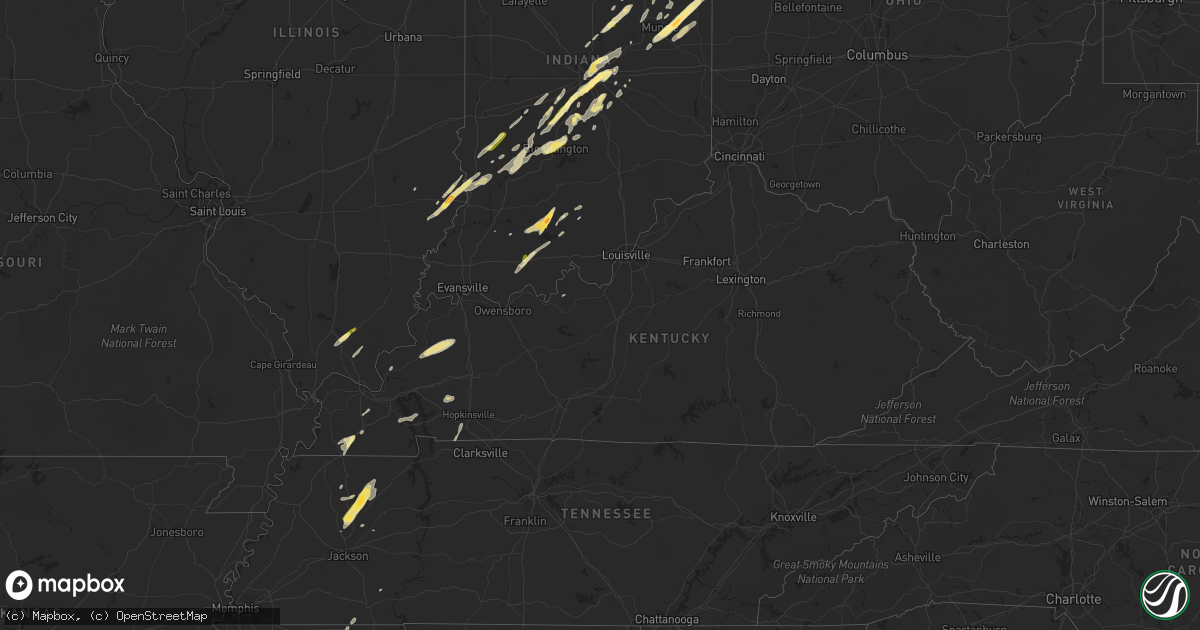
Hail Map in Kentucky on March 27, 2016
Get this storm
March 27 map
$229
one time, instant access
Download today. No call, no setup
Keep the $229
Bought the map and want the full workflow? Apply the entire $229 to a subscription within 7 days. None of it is wasted.
Every map, not just this one
This buys you this map. Subscription and you get every map we run, in the markets you choose from a few cities to whole states to nationwide. Plus real-time alerts the moment a storm fires.
Contact data
Name, contact info, occupancy, even credit band for addresses in the footprint. You go from where it hit to who to call.
Become the source they trust
Unlimited branding weather history reports on demand. You already have the documented answer ready for the property owner, and you are the one who showed up with it.
Property data and RoofTrace estimates
Pull up any address you have got, its value and the exact code rules for that jurisdiction, straight from One Click Code. Then RoofTrace estimates the squares, pitch, and roof value, priced the way you price.
Storm reports in Kentucky
Kentucky
| Date | Description |
|---|---|
| 03/27/20166:58 PM CDT | Unconfirmed tornado approximately 0.2 miles nne of cerulean kentucky. One barn blown away. One house with roof damage. Damage to one garage building. Several storage sh |
| 03/27/20164:25 PM CDT | Quarter size hail reported. |
| 03/26/20168:50 PM CDT | Shingle damage to several residences just north of rineyville. Late report. |
| 03/26/20168:45 PM CDT | Shingle damage to residence. Late report. |
| 03/26/20167:35 PM CDT | An ef0 tornado touched down at 735 pm cdt 2.7 miles southeast of white plains... Or just west of the christian/muhlenberg line. This tornado traveled northeast into muhle (pa |
| 03/26/20167:19 PM CDT | Unconfirmed...power outages reported |
| 03/26/20167:19 PM CDT | Tornado unconfirmed...but power outages reported along with barn completely destroyed near old palestine road and several nearby houses heavily damaged |
| 03/26/20167:11 PM CDT | A ef0 tornado touched down 5.4 miles west of crofton at 711 pm cdt and traveled east northeast for 3.4 miles to 2 miles west of crofton at 717 pm cdt. Survey revealed m |
| 03/26/20167:09 PM CDT | Tornado unconfirmed...barn has roof off on princeton road northwest of hopkinsville...several houses damaged. No injuries. |
| 03/26/20167:00 PM CDT | An ef2 tornado touched down 2.5 miles northeast of cerulean just east of the trigg/christian county line at 700 pm cdt. The tornado traveled east northeast for 15.7 mil |
All States Impacted by Hail Map on March 27, 2016
Cities Impacted by Hail Map on March 27, 2016
- Markle, IN
- Roanoke, IN
- Tullos, LA
- Kelly, LA
- Olla, LA
- Bloomfield, IN
- Lyons, IN
- Greenfield, TN
- McKenzie, TN
- Atwood, TN
- Bridgeport, IL
- Saint Francisville, IL
- Lawrenceville, IL
- Sumner, IL
- Morgantown, IN
- Martinsville, IN
- Uniondale, IN
- Bluffton, IN
- Grayson, LA
- Sikes, LA
- Morristown, IN
- Greenfield, IN
- Wingo, KY
- Bowling Green, OH
- Fort Wayne, IN
- Grabill, IN
- Leo, IN
- Spencerville, IN
- Edwardsport, IN
- Oaktown, IN
- Bruceville, IN
- Parkersburg, IL
- Freelandville, IN
- West Salem, IL
- Flat Rock, IL
- Sandborn, IN
- Carlisle, IN
- Farmland, IN
- Losantville, IN
- Selma, IN
- Modoc, IN
- Winchester, IN
- Parker City, IN
- Garrett, IN
- Paoli, IN
- Marion, IN
- McClure, OH
- Malinta, OH
- Hamler, OH
- Holgate, OH
- Grelton, OH
- Deshler, OH
- Napoleon, OH
- Milton Center, OH
- Oakwood, OH
- Latty, OH
- Warren, IN
- Decatur, IN
- Grand Rapids, OH
- Haviland, OH
- Petroleum, IN
- Liberty Center, IN
- Paulding, OH
- Weston, OH
- Convoy, OH
- Ossian, IN
- Keystone, IN
- Monroeville, IN
- Melrose, OH
- Huntington, IN
- Defiance, OH
- Scott, OH
- Rudolph, OH
- Van Buren, IN
- Cecil, OH
- Payne, OH
- Pennville, IN
- Hoagland, IN
- Craigville, IN
- Continental, OH
- New Bavaria, OH
- Montpelier, IN
- Custar, OH
- Franklin, IN
- Greenwood, IN
- Bargersville, IN
- Trafalgar, IN
- Indianapolis, IN
- Whiteland, IN
- Bloomington, IN
- Unionville, IN
- Tipton, IN
- Cicero, IN
- Elwood, IN
- Alexandria, IN
- Arcadia, IN
- Atlanta, IN
- Frankton, IN
- Summitville, IN
- Westfield, IN
- Noblesville, IN
- Falkner, MS
- Tiplersville, MS
- Muncie, IN
- Ripley, MS
- Walnut, MS
- Hopkinsville, KY
- Herndon, KY
- Gosport, IN
- Quincy, IN
- Paragon, IN
- Mccordsville, IN
- Beech Grove, IN
- Mooresville, IN
- Brooklyn, IN
- New Palestine, IN
- Camby, IN
- Marion, KY
- Providence, KY
- Clay, KY
- Dixon, KY
- Walbridge, OH
- Perrysburg, OH
- Hickory, KY
- Boaz, KY
- Pocahontas, TN
- Ridgeville, IN
- Portland, IN
- Jasonville, IN
- Clayton, IN
- Monrovia, IN
- Churubusco, IN
- Redkey, IN
- Springport, IN
- Middletown, IN
- Daleville, IN
- Albany, IN
- Columbia City, IN
- Olmsted, IL
- Villa Ridge, IL
- Milan, TN
- Trezevant, TN
- Bradford, TN
- Webster, KY
- Jennings, LA
- Mermentau, LA
- Morse, LA
- Roanoke, LA
- Lake Arthur, LA
- Welsh, LA
- Jasper, IN
- Avilla, IN
- Corunna, IN
- Dubois, IN
- West Baden Springs, IN
- French Lick, IN
- Orleans, IN
- Solsberry, IN
- Cloverdale, IN
- Hartford City, IN
- Fishers, IN
- Petersburg, MI
- Coal City, IN
- Worthington, IN
- Freedom, IN
- Monroe, MI
- Carleton, MI
- Birdseye, IN
- Ferdinand, IN
- Saint Meinrad, IN
- Shelburn, IN
- Nineveh, IN
- Gleason, TN
- Creal Springs, IL
- Ozark, IL
- Vienna, IL
- Buncombe, IL
- New Burnside, IL
- Goreville, IL
- Laotto, IN
- Dundas, IL
- Iota, LA
- Evangeline, LA
- Humboldt, TN
- Trenton, TN
- Linton, IN
- Benton, KY
- Upland, IN
- Eaton, IN
- Fortville, IN
- Pendleton, IN
- Anderson, IN
- Edgerton, OH
- Hicksville, OH
- Campbellsburg, IN
- Sullivan, IN
- Coalmont, IN
- Mark Center, OH
- Winnsboro, LA
- Water Valley, KY
- Clinton, KY
- Mayfield, KY
- Shoals, IN
- Paris, TN
- Henry, TN
- Jonesboro, IN
- Swayzee, IN
- Fairmount, IN
- Spencer, IN
- Ellettsville, IN
- Santa Claus, IN
- Dale, IN
- Lyons, OH
- Wauseon, OH
- Delta, OH
- Lewis, IN
- Clay City, IN
- Dunkirk, IN
- Cerulean, KY
- Princeton, KY
- Sharon, TN
- Yorktown, IN
- Gaston, IN
- Stilesville, IN
- Fairland, IN
- Fountaintown, IN
- Shelbyville, IN
- Iowa, LA
- Sidon, MS
- Greenwood, MS
- Salem, KY
- Burna, KY
- Bryant, IN
- Gas City, IN
- Coatesville, IN
- Greencastle, IN
- Butler, IN
- Saint Joe, IN
- Bryan, OH
- Yoder, IN
- Swanton, OH
- Needham, IN
- Boggstown, IN
- Stony Ridge, OH
- Northwood, OH
- Millbury, OH
- Dunbridge, OH
- Oregon, OH
- Sunset, LA
- Plainfield, IN
- Palestine, IL
- Slaughters, KY
- Geneva, IN
- Eckerty, IN
- Taswell, IN
- Lamar, IN
- Windfall, IN
- Metamora, OH
- Dugger, IN
- Fulton, KY
- Grantsburg, IL
- Simpson, IL
- Golconda, IL
- Winslow, IN
- Petersburg, IN
- Rutherford, TN
- Nashville, IN
- Adamsville, TN
- Crowley, LA
- Switz City, IN
- Dundee, MI
- Ida, MI
- Church Point, LA
- Albion, IN
- Newport, MI
- Cruger, MS
- Itta Bena, MS
- Belzoni, MS
- Lavinia, TN
- Stinesville, IN
- Temperance, MI
- Sylvania, OH
- Toledo, OH
- Maumee, OH
- Cedar Grove, TN
- Martin, OH
- Curtice, OH
- Blissfield, MI
- Wisner, LA
- Poland, IN
- Bowling Green, IN
- Ottawa Lake, MI
- Stonefort, IL


