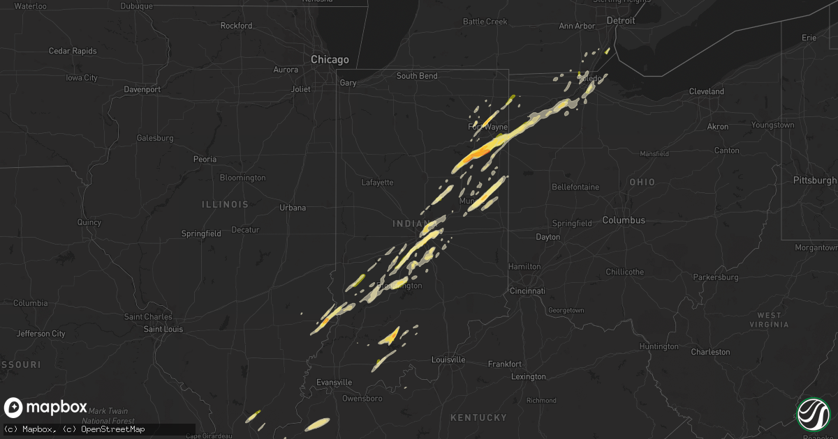
Hail Map in Indiana on March 27, 2016
Get this storm
March 27 map
$229
one time, instant access
Download today. No call, no setup
Keep the $229
Bought the map and want the full workflow? Apply the entire $229 to a subscription within 7 days. None of it is wasted.
Every map, not just this one
This buys you this map. Subscription and you get every map we run, in the markets you choose from a few cities to whole states to nationwide. Plus real-time alerts the moment a storm fires.
Contact data
Name, contact info, occupancy, even credit band for addresses in the footprint. You go from where it hit to who to call.
Become the source they trust
Unlimited branding weather history reports on demand. You already have the documented answer ready for the property owner, and you are the one who showed up with it.
Property data and RoofTrace estimates
Pull up any address you have got, its value and the exact code rules for that jurisdiction, straight from One Click Code. Then RoofTrace estimates the squares, pitch, and roof value, priced the way you price.
Storm reports in Indiana
Indiana
| Date | Description |
|---|---|
| 03/27/20166:47 PM CDT | A local report indicates 1.25 inch wind near FERDINAND |
| 03/27/20166:40 PM CDT | Dime to quarter size hail |
| 03/27/20166:30 PM CDT | A local report indicates 1.00 inch wind near 2 SSE MAPLES |
| 03/27/20166:15 PM CDT | A local report indicates 1.00 inch wind near CLAY CITY |
| 03/27/20166:00 PM CDT | A local report indicates 1.00 inch wind near 1 SE MONMOUTH |
| 03/27/20165:57 PM CDT | Multiple reports of hail 0.88 inch to 1.0 in diameter. |
| 03/27/20165:50 PM CDT | Multiple reports of quarter to ping pong sized hail. |
| 03/27/20165:45 PM CDT | Multiple reports of dime-quarter sized hail. |
| 03/27/20165:43 PM CDT | A local report indicates 1.00 inch wind near 2 SW TOCSIN |
| 03/27/20165:40 PM CDT | A local report indicates 1.25 inch wind near KINGSLAND |
| 03/27/20165:38 PM CDT | A local report indicates 1.25 inch wind near 1 SSE KINGSLAND |
| 03/27/20165:35 PM CDT | A local report indicates 1.75 inch wind near 1 NW BLUFFTON |
| 03/27/20165:20 PM CDT | A local report indicates 1.00 inch wind near 2 NE WARREN |
| 03/27/20165:18 PM CDT | A local report indicates 1.00 inch wind near ELWOOD |
| 03/27/20165:15 PM CDT | Siding damage... Screen damage and a broken window due to hail. |
| 03/27/20165:13 PM CDT | Siding and screen damage from hail at several houses along cr 1000 s west of sr 5. |
| 03/27/20165:13 PM CDT | Photos sent in from warren of ping pong sized hail. |
| 03/27/20165:10 PM CDT | Tree downed between paragon and eminence near morgan and owen county line. Time estimated from radar. |
| 03/27/20164:56 PM CDT | Near sr 128 and sr 37. |
| 03/27/20164:45 PM CDT | Hail lasted for five minutes...largest stones quarter size. |
| 03/27/20164:32 PM CDT | Tree blown down near front of the courthouse. Also penny to nickel size hail. |
| 03/26/20169:20 PM CDT | One tree was reported knocked down at the intersection of us 27 and esteb rd. |
| 03/26/20169:16 PM CDT | A local report indicates 59 MPH wind near KRID RICHMOND APT |
| 03/26/20169:05 PM CDT | Power lines reported down. Pole to pole. |
| 03/26/20168:53 PM CDT | Large tree down near intersection of county roads 400 n and n 450 w. |
| 03/26/20168:00 PM CDT | 1 inch hail on 200 n near mt comfort |
| 03/26/20167:50 PM CDT | 1 inch hail on us 31 in franklin |
| 03/26/20167:39 PM CDT | Ping pong size hail near southport high school |
| 03/26/20167:36 PM CDT | Hail size estimated at raymond and franklin se indy. |
| 03/26/20167:35 PM CDT | Se indy near arlington and southeastern. |
| 03/26/20167:34 PM CDT | A local report indicates 1.50 inch wind near PARKER CITY |
| 03/26/20167:34 PM CDT | Near beech grove city hall |
| 03/26/20167:30 PM CDT | Half dollar size hail from the uindy area around 830 pm |
| 03/26/20167:29 PM CDT | Quarter size hail south side indy near us 31 and thompson rd. |
| 03/26/20167:28 PM CDT | Roof torn off of a gas station |
| 03/26/20167:24 PM CDT | A local report indicates 1.00 inch wind near PARKER CITY |
| 03/26/20167:21 PM CDT | A local report indicates 1.00 inch wind near SW BLOOMINGTON |
| 03/26/20167:18 PM CDT | 1 inch hail near iu football stadium |
| 03/26/20167:10 PM CDT | A local report indicates 1.00 inch wind near 6 W TRAFALGAR |
| 03/26/20167:05 PM CDT | A local report indicates 1.25 inch wind near CENTERTON |
| 03/26/20167:03 PM CDT | A local report indicates 1.00 inch wind near WEST BADEN SPRINGS |
| 03/26/20167:02 PM CDT | A local report indicates 1.00 inch wind near BROOKLYN |
| 03/26/20167:02 PM CDT | Tree down on route 43 2 miles nw cincinatti indiana |
| 03/26/20167:01 PM CDT | A local report indicates 1.75 inch wind near FRENCH LICK |
All States Impacted by Hail Map on March 27, 2016
Cities Impacted by Hail Map on March 27, 2016
- Markle, IN
- Roanoke, IN
- Tullos, LA
- Kelly, LA
- Olla, LA
- Bloomfield, IN
- Lyons, IN
- Greenfield, TN
- McKenzie, TN
- Atwood, TN
- Bridgeport, IL
- Saint Francisville, IL
- Lawrenceville, IL
- Sumner, IL
- Morgantown, IN
- Martinsville, IN
- Uniondale, IN
- Bluffton, IN
- Grayson, LA
- Sikes, LA
- Morristown, IN
- Greenfield, IN
- Wingo, KY
- Bowling Green, OH
- Fort Wayne, IN
- Grabill, IN
- Leo, IN
- Spencerville, IN
- Edwardsport, IN
- Oaktown, IN
- Bruceville, IN
- Parkersburg, IL
- Freelandville, IN
- West Salem, IL
- Flat Rock, IL
- Sandborn, IN
- Carlisle, IN
- Farmland, IN
- Losantville, IN
- Selma, IN
- Modoc, IN
- Winchester, IN
- Parker City, IN
- Garrett, IN
- Paoli, IN
- Marion, IN
- McClure, OH
- Malinta, OH
- Hamler, OH
- Holgate, OH
- Grelton, OH
- Deshler, OH
- Napoleon, OH
- Milton Center, OH
- Oakwood, OH
- Latty, OH
- Warren, IN
- Decatur, IN
- Grand Rapids, OH
- Haviland, OH
- Petroleum, IN
- Liberty Center, IN
- Paulding, OH
- Weston, OH
- Convoy, OH
- Ossian, IN
- Keystone, IN
- Monroeville, IN
- Melrose, OH
- Huntington, IN
- Defiance, OH
- Scott, OH
- Rudolph, OH
- Van Buren, IN
- Cecil, OH
- Payne, OH
- Pennville, IN
- Hoagland, IN
- Craigville, IN
- Continental, OH
- New Bavaria, OH
- Montpelier, IN
- Custar, OH
- Franklin, IN
- Greenwood, IN
- Bargersville, IN
- Trafalgar, IN
- Indianapolis, IN
- Whiteland, IN
- Bloomington, IN
- Unionville, IN
- Tipton, IN
- Cicero, IN
- Elwood, IN
- Alexandria, IN
- Arcadia, IN
- Atlanta, IN
- Frankton, IN
- Summitville, IN
- Westfield, IN
- Noblesville, IN
- Falkner, MS
- Tiplersville, MS
- Muncie, IN
- Ripley, MS
- Walnut, MS
- Hopkinsville, KY
- Herndon, KY
- Gosport, IN
- Quincy, IN
- Paragon, IN
- Mccordsville, IN
- Beech Grove, IN
- Mooresville, IN
- Brooklyn, IN
- New Palestine, IN
- Camby, IN
- Marion, KY
- Providence, KY
- Clay, KY
- Dixon, KY
- Walbridge, OH
- Perrysburg, OH
- Hickory, KY
- Boaz, KY
- Pocahontas, TN
- Ridgeville, IN
- Portland, IN
- Jasonville, IN
- Clayton, IN
- Monrovia, IN
- Churubusco, IN
- Redkey, IN
- Springport, IN
- Middletown, IN
- Daleville, IN
- Albany, IN
- Columbia City, IN
- Olmsted, IL
- Villa Ridge, IL
- Milan, TN
- Trezevant, TN
- Bradford, TN
- Webster, KY
- Jennings, LA
- Mermentau, LA
- Morse, LA
- Roanoke, LA
- Lake Arthur, LA
- Welsh, LA
- Jasper, IN
- Avilla, IN
- Corunna, IN
- Dubois, IN
- West Baden Springs, IN
- French Lick, IN
- Orleans, IN
- Solsberry, IN
- Cloverdale, IN
- Hartford City, IN
- Fishers, IN
- Petersburg, MI
- Coal City, IN
- Worthington, IN
- Freedom, IN
- Monroe, MI
- Carleton, MI
- Birdseye, IN
- Ferdinand, IN
- Saint Meinrad, IN
- Shelburn, IN
- Nineveh, IN
- Gleason, TN
- Creal Springs, IL
- Ozark, IL
- Vienna, IL
- Buncombe, IL
- New Burnside, IL
- Goreville, IL
- Laotto, IN
- Dundas, IL
- Iota, LA
- Evangeline, LA
- Humboldt, TN
- Trenton, TN
- Linton, IN
- Benton, KY
- Upland, IN
- Eaton, IN
- Fortville, IN
- Pendleton, IN
- Anderson, IN
- Edgerton, OH
- Hicksville, OH
- Campbellsburg, IN
- Sullivan, IN
- Coalmont, IN
- Mark Center, OH
- Winnsboro, LA
- Water Valley, KY
- Clinton, KY
- Mayfield, KY
- Shoals, IN
- Paris, TN
- Henry, TN
- Jonesboro, IN
- Swayzee, IN
- Fairmount, IN
- Spencer, IN
- Ellettsville, IN
- Santa Claus, IN
- Dale, IN
- Lyons, OH
- Wauseon, OH
- Delta, OH
- Lewis, IN
- Clay City, IN
- Dunkirk, IN
- Cerulean, KY
- Princeton, KY
- Sharon, TN
- Yorktown, IN
- Gaston, IN
- Stilesville, IN
- Fairland, IN
- Fountaintown, IN
- Shelbyville, IN
- Iowa, LA
- Sidon, MS
- Greenwood, MS
- Salem, KY
- Burna, KY
- Bryant, IN
- Gas City, IN
- Coatesville, IN
- Greencastle, IN
- Butler, IN
- Saint Joe, IN
- Bryan, OH
- Yoder, IN
- Swanton, OH
- Needham, IN
- Boggstown, IN
- Stony Ridge, OH
- Northwood, OH
- Millbury, OH
- Dunbridge, OH
- Oregon, OH
- Sunset, LA
- Plainfield, IN
- Palestine, IL
- Slaughters, KY
- Geneva, IN
- Eckerty, IN
- Taswell, IN
- Lamar, IN
- Windfall, IN
- Metamora, OH
- Dugger, IN
- Fulton, KY
- Grantsburg, IL
- Simpson, IL
- Golconda, IL
- Winslow, IN
- Petersburg, IN
- Rutherford, TN
- Nashville, IN
- Adamsville, TN
- Crowley, LA
- Switz City, IN
- Dundee, MI
- Ida, MI
- Church Point, LA
- Albion, IN
- Newport, MI
- Cruger, MS
- Itta Bena, MS
- Belzoni, MS
- Lavinia, TN
- Stinesville, IN
- Temperance, MI
- Sylvania, OH
- Toledo, OH
- Maumee, OH
- Cedar Grove, TN
- Martin, OH
- Curtice, OH
- Blissfield, MI
- Wisner, LA
- Poland, IN
- Bowling Green, IN
- Ottawa Lake, MI
- Stonefort, IL


