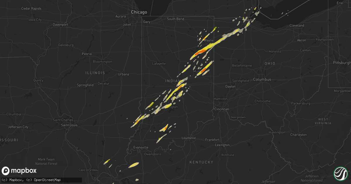
Hail Map on March 27, 2016
Get this storm
March 27 map
$229
one time, instant access
Download today. No call, no setup
Keep the $229
Bought the map and want the full workflow? Apply the entire $229 to a subscription within 7 days. None of it is wasted.
Every map, not just this one
This buys you this map. Subscription and you get every map we run, in the markets you choose from a few cities to whole states to nationwide. Plus real-time alerts the moment a storm fires.
Contact data
Name, contact info, occupancy, even credit band for addresses in the footprint. You go from where it hit to who to call.
Become the source they trust
Unlimited branding weather history reports on demand. You already have the documented answer ready for the property owner, and you are the one who showed up with it.
Property data and RoofTrace estimates
Pull up any address you have got, its value and the exact code rules for that jurisdiction, straight from One Click Code. Then RoofTrace estimates the squares, pitch, and roof value, priced the way you price.
States Impacted by Hail Map on March 27, 2016
Storm reports
Tennessee
| Date | Description |
|---|---|
| 03/27/20165:30 PM CDT | County em reports 20 or more trees down... A damaged shop... Several sheds blown away... And a roof ripped off of a barn south of camdedn on old natchez trace rd and hw |
| 03/27/20164:15 PM CDT | Picture of golf ball sized hail on stafford store rd in southern weakley county |
| 03/27/20164:10 PM CDT | Broadcast media passed along a photo via twitter of quarter sized hail |
| 03/27/20164:10 PM CDT | A local report indicates 1.00 inch wind near SKULLBONE |
Michigan
| Date | Description |
|---|---|
| 03/26/20167:55 PM CDT | Report via facebook |
Indiana
| Date | Description |
|---|---|
| 03/27/20166:47 PM CDT | A local report indicates 1.25 inch wind near FERDINAND |
| 03/27/20166:40 PM CDT | Dime to quarter size hail |
| 03/27/20166:30 PM CDT | A local report indicates 1.00 inch wind near 2 SSE MAPLES |
| 03/27/20166:15 PM CDT | A local report indicates 1.00 inch wind near CLAY CITY |
| 03/27/20166:00 PM CDT | A local report indicates 1.00 inch wind near 1 SE MONMOUTH |
| 03/27/20165:57 PM CDT | Multiple reports of hail 0.88 inch to 1.0 in diameter. |
| 03/27/20165:50 PM CDT | Multiple reports of quarter to ping pong sized hail. |
| 03/27/20165:45 PM CDT | Multiple reports of dime-quarter sized hail. |
| 03/27/20165:43 PM CDT | A local report indicates 1.00 inch wind near 2 SW TOCSIN |
| 03/27/20165:40 PM CDT | A local report indicates 1.25 inch wind near KINGSLAND |
| 03/27/20165:38 PM CDT | A local report indicates 1.25 inch wind near 1 SSE KINGSLAND |
| 03/27/20165:35 PM CDT | A local report indicates 1.75 inch wind near 1 NW BLUFFTON |
| 03/27/20165:20 PM CDT | A local report indicates 1.00 inch wind near 2 NE WARREN |
| 03/27/20165:18 PM CDT | A local report indicates 1.00 inch wind near ELWOOD |
| 03/27/20165:15 PM CDT | Siding damage... Screen damage and a broken window due to hail. |
| 03/27/20165:13 PM CDT | Siding and screen damage from hail at several houses along cr 1000 s west of sr 5. |
| 03/27/20165:13 PM CDT | Photos sent in from warren of ping pong sized hail. |
| 03/27/20165:10 PM CDT | Tree downed between paragon and eminence near morgan and owen county line. Time estimated from radar. |
| 03/27/20164:56 PM CDT | Near sr 128 and sr 37. |
| 03/27/20164:45 PM CDT | Hail lasted for five minutes...largest stones quarter size. |
| 03/27/20164:32 PM CDT | Tree blown down near front of the courthouse. Also penny to nickel size hail. |
| 03/26/20169:20 PM CDT | One tree was reported knocked down at the intersection of us 27 and esteb rd. |
| 03/26/20169:16 PM CDT | A local report indicates 59 MPH wind near KRID RICHMOND APT |
| 03/26/20169:05 PM CDT | Power lines reported down. Pole to pole. |
| 03/26/20168:53 PM CDT | Large tree down near intersection of county roads 400 n and n 450 w. |
| 03/26/20168:00 PM CDT | 1 inch hail on 200 n near mt comfort |
| 03/26/20167:50 PM CDT | 1 inch hail on us 31 in franklin |
| 03/26/20167:39 PM CDT | Ping pong size hail near southport high school |
| 03/26/20167:36 PM CDT | Hail size estimated at raymond and franklin se indy. |
| 03/26/20167:35 PM CDT | Se indy near arlington and southeastern. |
| 03/26/20167:34 PM CDT | Near beech grove city hall |
| 03/26/20167:34 PM CDT | A local report indicates 1.50 inch wind near PARKER CITY |
| 03/26/20167:30 PM CDT | Half dollar size hail from the uindy area around 830 pm |
| 03/26/20167:29 PM CDT | Quarter size hail south side indy near us 31 and thompson rd. |
| 03/26/20167:28 PM CDT | Roof torn off of a gas station |
| 03/26/20167:24 PM CDT | A local report indicates 1.00 inch wind near PARKER CITY |
| 03/26/20167:21 PM CDT | A local report indicates 1.00 inch wind near SW BLOOMINGTON |
| 03/26/20167:18 PM CDT | 1 inch hail near iu football stadium |
| 03/26/20167:10 PM CDT | A local report indicates 1.00 inch wind near 6 W TRAFALGAR |
| 03/26/20167:05 PM CDT | A local report indicates 1.25 inch wind near CENTERTON |
| 03/26/20167:03 PM CDT | A local report indicates 1.00 inch wind near WEST BADEN SPRINGS |
| 03/26/20167:02 PM CDT | Tree down on route 43 2 miles nw cincinatti indiana |
| 03/26/20167:02 PM CDT | A local report indicates 1.00 inch wind near BROOKLYN |
| 03/26/20167:01 PM CDT | A local report indicates 1.75 inch wind near FRENCH LICK |
Kentucky
| Date | Description |
|---|---|
| 03/27/20166:58 PM CDT | Unconfirmed tornado approximately 0.2 miles nne of cerulean kentucky. One barn blown away. One house with roof damage. Damage to one garage building. Several storage sh |
| 03/27/20164:25 PM CDT | Quarter size hail reported. |
| 03/26/20168:50 PM CDT | Shingle damage to several residences just north of rineyville. Late report. |
| 03/26/20168:45 PM CDT | Shingle damage to residence. Late report. |
| 03/26/20167:35 PM CDT | An ef0 tornado touched down at 735 pm cdt 2.7 miles southeast of white plains... Or just west of the christian/muhlenberg line. This tornado traveled northeast into muhle (pa |
| 03/26/20167:19 PM CDT | Unconfirmed...power outages reported |
| 03/26/20167:19 PM CDT | Tornado unconfirmed...but power outages reported along with barn completely destroyed near old palestine road and several nearby houses heavily damaged |
| 03/26/20167:11 PM CDT | A ef0 tornado touched down 5.4 miles west of crofton at 711 pm cdt and traveled east northeast for 3.4 miles to 2 miles west of crofton at 717 pm cdt. Survey revealed m |
| 03/26/20167:09 PM CDT | Tornado unconfirmed...barn has roof off on princeton road northwest of hopkinsville...several houses damaged. No injuries. |
| 03/26/20167:00 PM CDT | An ef2 tornado touched down 2.5 miles northeast of cerulean just east of the trigg/christian county line at 700 pm cdt. The tornado traveled east northeast for 15.7 mil |
Ohio
| Date | Description |
|---|---|
| 03/27/20166:40 PM CDT | Estimated nickle to quarter sized hail from pictures. |
| 03/27/20166:30 PM CDT | Penny to quarter-sized hail. |
| 03/26/201610:37 PM CDT | Part of a factory roof was peeled off. Nearby tractor trailers and campers were blown on their sides. Side of hanger at nearby hardin county airport also blown in. |
| 03/26/201610:22 PM CDT | Barn blown down on county road 200. |
| 03/26/201610:22 PM CDT | Several trees and powerlines down across southern parts of the county including along county rds 163 and 130. |
| 03/26/201610:18 PM CDT | Damage to a fence and scoreboard at riverside high school. Several trees downed in the area. |
| 03/26/201610:17 PM CDT | Based on photos... 40 ft tall tree with 2 ft diameter fell. Tree had a shallow root system. Wood playground set/clubhouse blown over as well. |
| 03/26/201610:16 PM CDT | Barn on county road 63 was destroyed and a cedar tree snapped. |
| 03/26/201610:15 PM CDT | Tree with lines down blocking eastbound lane of creek rd. |
| 03/26/20169:59 PM CDT | Two large trees downed along hardin-wapakoneta road |
| 03/26/20169:56 PM CDT | Several large limbs downed at the troy country club. |
| 03/26/20169:34 PM CDT | One tree down near the 4000 block of state route 121. |
| 03/26/20169:33 PM CDT | Roof blown off garage located on rockridge road. Neighbors pole barn was destroyed and house sustained significant wind damage. |
| 03/26/20169:22 PM CDT | Tree down across crawfordsville campbellstown rd near new hope. |
| 03/26/20168:01 PM CDT | A local report indicates 1.00 inch wind near SYLVANIA |
| 03/26/20168:01 PM CDT | A local report indicates 1.00 inch wind near 2 SW GRAND RAPIDS |
| 03/26/20167:50 PM CDT | Dime to quarter size hail. |
| 03/26/20167:42 PM CDT | Delayed report. |
Illinois
| Date | Description |
|---|---|
| 03/27/20165:30 PM CDT | A local report indicates 1.00 inch wind near LAWRENCEVILLE |
| 03/27/20164:15 PM CDT | Quarter size hail reported. |
Cities Impacted by Hail Map on March 27, 2016
- Markle, IN
- Roanoke, IN
- Tullos, LA
- Kelly, LA
- Olla, LA
- Bloomfield, IN
- Lyons, IN
- Greenfield, TN
- McKenzie, TN
- Atwood, TN
- Bridgeport, IL
- Saint Francisville, IL
- Lawrenceville, IL
- Sumner, IL
- Morgantown, IN
- Martinsville, IN
- Uniondale, IN
- Bluffton, IN
- Grayson, LA
- Sikes, LA
- Morristown, IN
- Greenfield, IN
- Wingo, KY
- Bowling Green, OH
- Fort Wayne, IN
- Grabill, IN
- Leo, IN
- Spencerville, IN
- Edwardsport, IN
- Oaktown, IN
- Bruceville, IN
- Parkersburg, IL
- Freelandville, IN
- West Salem, IL
- Flat Rock, IL
- Sandborn, IN
- Carlisle, IN
- Farmland, IN
- Losantville, IN
- Selma, IN
- Modoc, IN
- Winchester, IN
- Parker City, IN
- Garrett, IN
- Paoli, IN
- Marion, IN
- McClure, OH
- Malinta, OH
- Hamler, OH
- Holgate, OH
- Grelton, OH
- Deshler, OH
- Napoleon, OH
- Milton Center, OH
- Oakwood, OH
- Latty, OH
- Warren, IN
- Decatur, IN
- Grand Rapids, OH
- Haviland, OH
- Petroleum, IN
- Liberty Center, IN
- Paulding, OH
- Weston, OH
- Convoy, OH
- Ossian, IN
- Keystone, IN
- Monroeville, IN
- Melrose, OH
- Huntington, IN
- Defiance, OH
- Scott, OH
- Rudolph, OH
- Van Buren, IN
- Cecil, OH
- Payne, OH
- Pennville, IN
- Hoagland, IN
- Craigville, IN
- Continental, OH
- New Bavaria, OH
- Montpelier, IN
- Custar, OH
- Franklin, IN
- Greenwood, IN
- Bargersville, IN
- Trafalgar, IN
- Indianapolis, IN
- Whiteland, IN
- Bloomington, IN
- Unionville, IN
- Tipton, IN
- Cicero, IN
- Elwood, IN
- Alexandria, IN
- Arcadia, IN
- Atlanta, IN
- Frankton, IN
- Summitville, IN
- Westfield, IN
- Noblesville, IN
- Falkner, MS
- Tiplersville, MS
- Muncie, IN
- Ripley, MS
- Walnut, MS
- Hopkinsville, KY
- Herndon, KY
- Gosport, IN
- Quincy, IN
- Paragon, IN
- Mccordsville, IN
- Beech Grove, IN
- Mooresville, IN
- Brooklyn, IN
- New Palestine, IN
- Camby, IN
- Marion, KY
- Providence, KY
- Clay, KY
- Dixon, KY
- Walbridge, OH
- Perrysburg, OH
- Hickory, KY
- Boaz, KY
- Pocahontas, TN
- Ridgeville, IN
- Portland, IN
- Jasonville, IN
- Clayton, IN
- Monrovia, IN
- Churubusco, IN
- Redkey, IN
- Springport, IN
- Middletown, IN
- Daleville, IN
- Albany, IN
- Columbia City, IN
- Olmsted, IL
- Villa Ridge, IL
- Milan, TN
- Trezevant, TN
- Bradford, TN
- Webster, KY
- Jennings, LA
- Mermentau, LA
- Morse, LA
- Roanoke, LA
- Lake Arthur, LA
- Welsh, LA
- Jasper, IN
- Avilla, IN
- Corunna, IN
- Dubois, IN
- West Baden Springs, IN
- French Lick, IN
- Orleans, IN
- Solsberry, IN
- Cloverdale, IN
- Hartford City, IN
- Fishers, IN
- Petersburg, MI
- Coal City, IN
- Worthington, IN
- Freedom, IN
- Monroe, MI
- Carleton, MI
- Birdseye, IN
- Ferdinand, IN
- Saint Meinrad, IN
- Shelburn, IN
- Nineveh, IN
- Gleason, TN
- Creal Springs, IL
- Ozark, IL
- Vienna, IL
- Buncombe, IL
- New Burnside, IL
- Goreville, IL
- Laotto, IN
- Dundas, IL
- Iota, LA
- Evangeline, LA
- Humboldt, TN
- Trenton, TN
- Linton, IN
- Benton, KY
- Upland, IN
- Eaton, IN
- Fortville, IN
- Pendleton, IN
- Anderson, IN
- Edgerton, OH
- Hicksville, OH
- Campbellsburg, IN
- Sullivan, IN
- Coalmont, IN
- Mark Center, OH
- Winnsboro, LA
- Water Valley, KY
- Clinton, KY
- Mayfield, KY
- Shoals, IN
- Paris, TN
- Henry, TN
- Jonesboro, IN
- Swayzee, IN
- Fairmount, IN
- Spencer, IN
- Ellettsville, IN
- Santa Claus, IN
- Dale, IN
- Lyons, OH
- Wauseon, OH
- Delta, OH
- Lewis, IN
- Clay City, IN
- Dunkirk, IN
- Cerulean, KY
- Princeton, KY
- Sharon, TN
- Yorktown, IN
- Gaston, IN
- Stilesville, IN
- Fairland, IN
- Fountaintown, IN
- Shelbyville, IN
- Iowa, LA
- Sidon, MS
- Greenwood, MS
- Salem, KY
- Burna, KY
- Bryant, IN
- Gas City, IN
- Coatesville, IN
- Greencastle, IN
- Butler, IN
- Saint Joe, IN
- Bryan, OH
- Yoder, IN
- Swanton, OH
- Needham, IN
- Boggstown, IN
- Stony Ridge, OH
- Northwood, OH
- Millbury, OH
- Dunbridge, OH
- Oregon, OH
- Sunset, LA
- Plainfield, IN
- Palestine, IL
- Slaughters, KY
- Geneva, IN
- Eckerty, IN
- Taswell, IN
- Lamar, IN
- Windfall, IN
- Metamora, OH
- Dugger, IN
- Fulton, KY
- Grantsburg, IL
- Simpson, IL
- Golconda, IL
- Winslow, IN
- Petersburg, IN
- Rutherford, TN
- Nashville, IN
- Adamsville, TN
- Crowley, LA
- Switz City, IN
- Dundee, MI
- Ida, MI
- Church Point, LA
- Albion, IN
- Newport, MI
- Cruger, MS
- Itta Bena, MS
- Belzoni, MS
- Lavinia, TN
- Stinesville, IN
- Temperance, MI
- Sylvania, OH
- Toledo, OH
- Maumee, OH
- Cedar Grove, TN
- Martin, OH
- Curtice, OH
- Blissfield, MI
- Wisner, LA
- Poland, IN
- Bowling Green, IN
- Ottawa Lake, MI
- Stonefort, IL