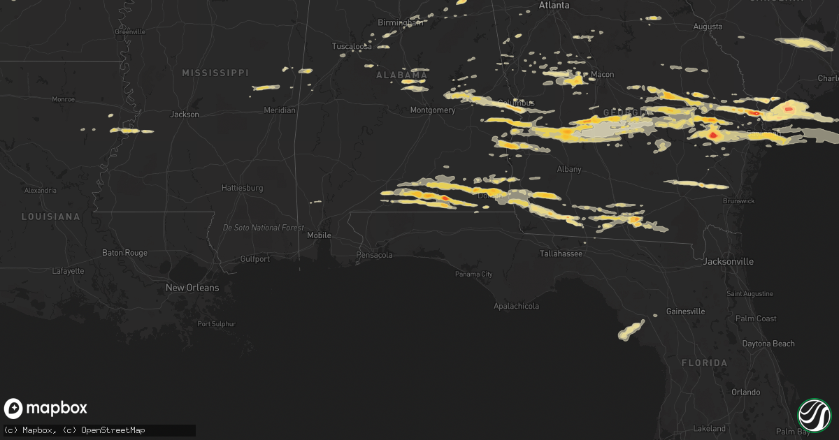
Hail Map in Mississippi on March 27, 2011
Get this storm
March 27 map
$229
one time, instant access
Download today. No call, no setup
Keep the $229
Bought the map and want the full workflow? Apply the entire $229 to a subscription within 7 days. None of it is wasted.
Every map, not just this one
This buys you this map. Subscription and you get every map we run, in the markets you choose from a few cities to whole states to nationwide. Plus real-time alerts the moment a storm fires.
Contact data
Name, contact info, occupancy, even credit band for addresses in the footprint. You go from where it hit to who to call.
Become the source they trust
Unlimited branding weather history reports on demand. You already have the documented answer ready for the property owner, and you are the one who showed up with it.
Property data and RoofTrace estimates
Pull up any address you have got, its value and the exact code rules for that jurisdiction, straight from One Click Code. Then RoofTrace estimates the squares, pitch, and roof value, priced the way you price.
Storm reports in Mississippi
Mississippi
| Date | Description |
|---|---|
| 03/27/20118:03 AM CDT | A local report indicates 1.25 inch wind near 1 NE HOUSE |
| 03/27/20117:51 AM CDT | Public report of quarter to half dollar hail between port gibson and vicksburg |
| 03/27/20117:00 AM CDT | A local report indicates 1.25 inch wind near 4 ENE PRESTON |
| 03/27/20111:05 AM CDT | A local report indicates 1.00 inch wind near 1 N TUPELO |
| 03/26/201111:46 PM CDT | A local report indicates 1.25 inch wind near TUPELO |
| 03/26/201111:33 PM CDT | A local report indicates 1.00 inch wind near TISHOMINGO |
| 03/26/201111:24 PM CDT | A local report indicates 1.00 inch wind near TISHOMINGO |
All States Impacted by Hail Map on March 27, 2011
Cities Impacted by Hail Map on March 27, 2011
- Woodbury, GA
- Gay, GA
- Molena, GA
- Umpire, AR
- Dierks, AR
- Tallulah, LA
- Musella, GA
- De Soto, GA
- Plains, GA
- Preston, GA
- Cobb, GA
- Smithville, GA
- Cordele, GA
- Richland, GA
- Leslie, GA
- Pitts, GA
- Americus, GA
- Abbeville, AL
- Columbia, AL
- Seale, AL
- Brent, AL
- Centreville, AL
- Georgetown, GA
- Eufaula, AL
- Beaufort, SC
- Springfield, GA
- Rincon, GA
- Newton, GA
- Camilla, GA
- Colquitt, GA
- Damascus, GA
- Leary, GA
- Cairo, GA
- Thorsby, AL
- Jemison, AL
- Newellton, LA
- Newnan, GA
- Little Rock, AR
- Savannah, GA
- Chester, GA
- Cochran, GA
- Metter, GA
- Daleville, AL
- Birmingham, AL
- Elko, GA
- Perry, GA
- Twin City, GA
- Hermanville, MS
- Utica, MS
- Port Gibson, MS
- Thomaston, GA
- Woodland, GA
- Gurdon, AR
- Fort Rucker, AL
- Elba, AL
- New Brockton, AL
- Newton, AL
- Enterprise, AL
- Opp, AL
- Kinston, AL
- Midland City, AL
- Nettleton, MS
- Verbena, AL
- Weaver, AL
- Jacksonville, AL
- Guyton, GA
- Plantersville, MS
- Shannon, MS
- Amory, MS
- Pontotoc, MS
- Houlka, MS
- Okolona, MS
- Port Royal, SC
- Saint Helena Island, SC
- Eastman, GA
- Vidalia, GA
- Lyons, GA
- Mount Vernon, GA
- Ailey, GA
- Hardeeville, SC
- Okatie, SC
- Bluffton, SC
- Hilton Head Island, SC
- England, AR
- Brunswick, GA
- Hortense, GA
- Patterson, GA
- Bessemer, AL
- McCalla, AL
- Dadeville, AL
- Headland, AL
- Naylor, GA
- Valdosta, GA
- Lake Park, GA
- Culloden, GA
- Ridgeland, SC
- Fort Stewart, GA
- Glennville, GA
- Claxton, GA
- Mantachie, MS
- Tupelo, MS
- Fulton, MS
- Mooreville, MS
- Gantt, AL
- Dothan, AL
- Andalusia, AL
- Webb, AL
- Ashford, AL
- Cowarts, AL
- Dozier, AL
- Notasulga, AL
- Tuskegee, AL
- Auburn, AL
- Chauncey, GA
- De Witt, AR
- Stuttgart, AR
- Altheimer, AR
- Star City, AR
- Sparkman, AR
- Carthage, AR
- Arkadelphia, AR
- Pine Bluff, AR
- Ivan, AR
- Fordyce, AR
- Yorktown, AR
- Gould, AR
- Grady, AR
- Kingsland, AR
- Rison, AR
- Pembroke, GA
- Hawkinsville, GA
- Emelle, AL
- Aliceville, AL
- Pavo, GA
- Moultrie, GA
- Butler, GA
- Knoxville, GA
- Roberta, GA
- Samson, AL
- Bloomingdale, GA
- Ellabell, GA
- Cuthbert, GA
- Midway, AL
- Morris, GA
- Clayton, AL
- Columbus, GA
- Fort Benning, GA
- Phenix City, AL
- Salem, AL
- Opelika, AL
- Chancellor, AL
- Brewton, AL
- Castleberry, AL
- Evergreen, AL
- Red Level, AL
- Florala, AL
- Geneva, AL
- Coffee Springs, AL
- Hartford, AL
- Slocomb, AL
- Lakeland, GA
- Morven, GA
- Dixie, GA
- Quitman, GA
- Hahira, GA
- Boston, GA
- Stockton, GA
- Barney, GA
- Smithville, MS
- Tallassee, AL
- Eclectic, AL
- Daviston, AL
- Alamo, GA
- Cadwell, GA
- Dublin, GA
- Rentz, GA
- Byromville, GA
- Weston, GA
- Abbeville, GA
- Rochelle, GA
- Unadilla, GA
- Pinehurst, GA
- Andersonville, GA
- Vienna, GA
- Montezuma, GA
- Reidsville, GA
- Collins, GA
- Tybee Island, GA
- Pooler, GA
- Richmond Hill, GA
- East Dublin, GA
- Swainsboro, GA
- Wrightsville, GA
- Adrian, GA
- Register, GA
- Statesboro, GA
- Tarrytown, GA
- Soperton, GA
- Glenwood, GA
- Rockledge, GA
- Prescott, AR
- Irwinton, GA
- Danville, GA
- Shellman, GA
- Lumpkin, GA
- Dawson, GA
- Meigs, GA
- Bonnerdale, AR
- Pearcy, AR
- Hot Springs National Park, AR
- Royal, AR
- Hensley, AR
- Old Town, FL
- Port Wentworth, GA
- North Little Rock, AR
- Hot Springs Village, AR
- Lonsdale, AR
- Coolidge, GA
- Allenhurst, GA
- Ludowici, GA
- Hinesville, GA
- Fosters, AL
- Ralph, AL
- Crawfordville, GA
- Scooba, MS
- Cusseta, GA
- Hurtsboro, AL
- Omaha, GA
- Pittsview, AL
- Hatchechubbee, AL
- Thomasville, GA
- Wadley, GA
- Bartow, GA
- Arcadia, FL
- Mabelvale, AR
- Statenville, GA
- Fargo, GA
- Moody Afb, GA
- Barwick, GA
- Du Pont, GA
- Vardaman, MS
- Pittsboro, MS
- Wetumpka, AL
- Newville, AL
- Alexandria, AL
- Wellington, AL
- Redfield, AR
- Blakely, GA
- Adel, GA
- Nashville, GA
- Ray City, GA
- Cobbtown, GA
- Brookwood, AL
- Shorterville, AL
- Citronelle, AL
- Sheridan, AR
- Shady Dale, GA
- Monticello, GA
- Anniston, AL
- Oxford, AL
- Eastaboga, AL
- Tuscaloosa, AL
- Brooklet, GA
- Macon, GA
- Piedmont, AL
- Lizella, GA
- Cottonwood, AL
- Caddo Gap, AR
- Greenville, GA
- Iron City, GA
- Whigham, GA
- Donalsonville, GA
- Ochlocknee, GA
- Jakin, GA
- Brinson, GA
- Gordon, AL
- Climax, GA
- Bainbridge, GA
- Horseshoe Beach, FL
- Billingsley, AL
- Prattville, AL
- Marbury, AL
- Deatsville, AL
- Garfield, GA
- Portal, GA
- Alexander, AR
- Alexander City, AL
- Tillman, SC
- Garnett, SC
- Stanton, AL
- Maplesville, AL
- Clanton, AL
- Trussville, AL
- Moody, AL
- Blackshear, GA
- Waycross, GA
- Mershon, GA
- Alma, GA
- Punta Gorda, FL
- Harleyville, SC
- Jesup, GA
- Benton, AR
- Livingston, AL
- Graceville, FL
- Bonifay, FL
- West Blocton, AL
- Hazlehurst, GA
- Trenton, FL
- Pine Mountain, GA
- Bauxite, AR
- Jessieville, AR
- Lanett, AL
- McRae Helena, GA
- Newington, GA
- Sylvania, GA
- Lumber City, GA
- Lincoln, AL
- Millen, GA
- Lonoke, AR
- Union, MS
- Philadelphia, MS
- Collinsville, MS
- De Kalb, MS
- Gillett, AR
- Camp Hill, AL
- Jackson, GA
- Locust Grove, GA
- Jenkinsburg, GA
- Bryant, AR
- Scott, AR
- Helena, AL
- Montevallo, AL
- Woodstock, AL
- Barnesville, GA
- Plainview, AR
- Lagrange, GA
- Carlisle, AR
- Rhine, GA
- Winfield, AL
- Brilliant, AL
- Ozark, AL
- Pineview, GA
- Malvern, AR
- Franklin, GA
- Union Springs, AL
- Monticello, FL
- Moncks Corner, SC
- Branchville, SC
- Cross, SC
- Dorchester, SC
- Bowman, SC
- Saint George, SC
- Summerville, SC
- Holly Hill, SC
- Ridgeville, SC
- Mountain Pine, AR
- Maumelle, AR
- Ohatchee, AL
- Okolona, AR
- Delight, AR
- Vance, MS
- Porterville, MS
- Shuqualak, MS
- Fort Mitchell, AL
- Traskwood, AR
- Leeds, AL
- Mansfield, GA
- Tuscumbia, AL
- Manchester, GA
- Five Points, AL
- Yatesville, GA
- Clyo, GA
- Rowesville, SC
- Cope, SC
- Reevesville, SC
- Forsyth, GA
- Daufuskie Island, SC
- Milan, GA
- Pell City, AL
- Reynolds, GA
- Pansey, AL
- Grannis, AR
- Wickes, AR
- Juliette, GA
- Belden, MS
- Winnsboro, LA
- Arlington, GA
- Murfreesboro, AR
- Milner, GA
- Detroit, AL
- Tremont, MS
- Greenwood Springs, MS
- Chiefland, FL
- Aberdeen, MS
- Fort Gaines, GA
- McIntosh, AL
- Mount Vernon, AL
- Buena Vista, GA
- Epes, AL
- Brantley, AL
- Jack, AL
- Mount Ida, AR
- Saltillo, MS
- Warm Springs, GA
- Weogufka, AL
- Zebulon, GA
- Williamson, GA
- Greensboro, GA
- Louisville, GA
- Midville, GA
- Talbotton, GA
- Byron, GA
- Clarksdale, MS
- Winston, GA
- Meansville, GA
- The Rock, GA
- Screven, GA
- Fort Valley, GA
- Pulaski, GA
- Kite, GA
- Davisboro, GA
- Sandersville, GA
- Cherokee, AL
- Surrency, GA
- Baxley, GA
- Williston, SC
- Pelham, GA
- New Albany, MS
- Cottondale, AL
- Glenwood, AL
- Millwood, GA
- Nicholls, GA
- Mena, AR
- Oglethorpe, GA
- Dexter, GA
- Baldwyn, MS
- Guntown, MS
- Tichnor, AR
- Alligator, MS
- Crumrod, AR
- Vance, AL
- West Point, GA
- Douglasville, GA
- Flovilla, GA
- Villa Rica, GA


