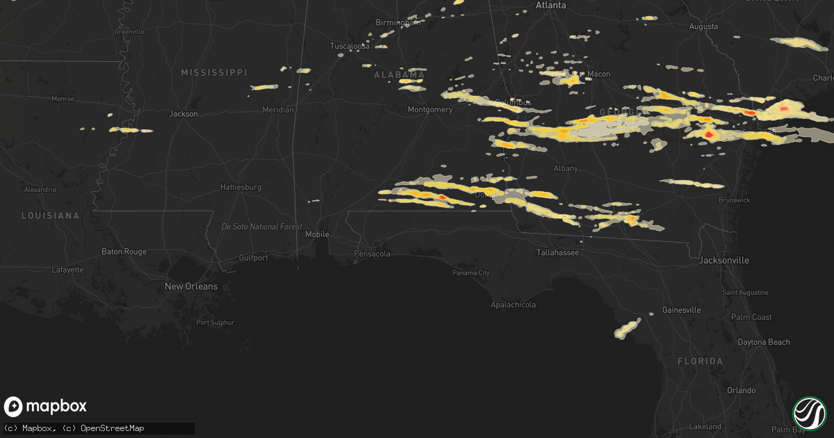
Hail Map in Alabama on March 27, 2011
Get this storm
March 27 map
$229
one time, instant access
Download today. No call, no setup
Keep the $229
Bought the map and want the full workflow? Apply the entire $229 to a subscription within 7 days. None of it is wasted.
Every map, not just this one
This buys you this map. Subscription and you get every map we run, in the markets you choose from a few cities to whole states to nationwide. Plus real-time alerts the moment a storm fires.
Contact data
Name, contact info, occupancy, even credit band for addresses in the footprint. You go from where it hit to who to call.
Become the source they trust
Unlimited branding weather history reports on demand. You already have the documented answer ready for the property owner, and you are the one who showed up with it.
Property data and RoofTrace estimates
Pull up any address you have got, its value and the exact code rules for that jurisdiction, straight from One Click Code. Then RoofTrace estimates the squares, pitch, and roof value, priced the way you price.
Storm reports in Alabama
Alabama
| Date | Description |
|---|---|
| 03/27/20114:10 PM CDT | A local report indicates 2.75 inch wind near PINEY GROVE |
| 03/27/20114:05 PM CDT | A local report indicates 1.75 inch wind near PINEY GROVE |
| 03/27/20114:00 PM CDT | A local report indicates 1.75 inch wind near DOTHAN |
| 03/27/20113:56 PM CDT | A local report indicates 1.75 inch wind near DOTHAN |
| 03/27/20113:43 PM CDT | Reported by spotter near hwy 52...estothel community. |
| 03/27/20113:37 PM CDT | A local report indicates 1.75 inch wind near WICKSBURG |
| 03/27/20113:34 PM CDT | Large hail report by ema. |
| 03/27/20113:30 PM CDT | Golf ball size hail reported by spotter. Damage to automobile windows to car/home in the horn hill community. |
| 03/27/20113:30 PM CDT | A local report indicates 1.00 inch wind near OZARK |
| 03/27/20113:30 PM CDT | A local report indicates 1.00 inch wind near CAIRNS AAF |
| 03/27/20113:20 PM CDT | Dime to quarter size hail reported. |
| 03/27/20113:16 PM CDT | Reported in the community by storm spotter. |
| 03/27/20113:16 PM CDT | Large hail report by spotter. |
| 03/27/20113:09 PM CDT | A local report indicates 1.00 inch wind near ENTERPRISE |
| 03/27/20112:06 PM CDT | Porch of a house completely collapsed as well as a collapsed barn. |
| 03/27/20112:06 PM CDT | Power poles down across roadways. |
| 03/27/20112:06 PM CDT | A local report indicates 1.00 inch wind near WEBB |
| 03/27/20112:00 PM CDT | A local report indicates 1.75 inch wind near KINSEY |
| 03/27/20111:50 PM CDT | Numerous trees down in pinckard. Tree on powerline in newton. |
| 03/27/20111:35 PM CDT | A local report indicates 1.50 inch wind near EUFAULA |
| 03/27/20111:26 PM CDT | A local report indicates 1.00 inch wind near 3 NE NAPIER FIELD |
| 03/27/20111:26 PM CDT | A local report indicates 1.00 inch wind near 3 NE DOTHAN |
| 03/27/201112:43 PM CDT | A local report indicates 1.75 inch wind near 10 SE SEALE |
| 03/27/201112:40 PM CDT | A local report indicates 1.00 inch wind near OZARK |
| 03/27/201110:15 AM CDT | A local report indicates 1.00 inch wind near VERBENA |
| 03/27/201110:12 AM CDT | A local report indicates 1.75 inch wind near ENTERPRISE |
| 03/27/20112:38 AM CDT | Dime to golf ball hail fell near jacksonville. A few pieces of hail may have been larger. One auto had cracked windshield. |
| 03/27/20112:26 AM CDT | Corrected for date |
| 03/27/20111:58 AM CDT | Quarter size hail on i-20 at moody exit |
| 03/27/20111:23 AM CDT | Nickel to quarter size hail briefly fell in bessemer. The hail covered the ground in places. |
| 03/27/20111:09 AM CDT | Nickel to quarter size hail briefly fell around abernant. |
| 03/27/201112:18 AM CDT | Dime to quarter size hail briefly fell in far southwestern marion county. |
| 03/26/201111:37 PM CDT | Hail one and one half inch in diameter...maybe larger near highway 165 in phenix city. |
| 03/26/201111:33 PM CDT | A local report indicates 1.50 inch wind near FORT MITCHELL |
| 03/26/201111:22 PM CDT | A local report indicates 1.25 inch wind near 1 E PARKMANVILLE |
| 03/26/201110:39 PM CDT | Quarter size hail and tree limbs down in notasulga. |
| 03/26/201110:19 PM CDT | Pea to quarter size hail fell in and around tallassee in elmore and tallapoosa counties. The hail completely covered the ground. |
All States Impacted by Hail Map on March 27, 2011
Cities Impacted by Hail Map on March 27, 2011
- Woodbury, GA
- Gay, GA
- Molena, GA
- Umpire, AR
- Dierks, AR
- Tallulah, LA
- Musella, GA
- De Soto, GA
- Plains, GA
- Preston, GA
- Cobb, GA
- Smithville, GA
- Cordele, GA
- Richland, GA
- Leslie, GA
- Pitts, GA
- Americus, GA
- Abbeville, AL
- Columbia, AL
- Seale, AL
- Brent, AL
- Centreville, AL
- Georgetown, GA
- Eufaula, AL
- Beaufort, SC
- Springfield, GA
- Rincon, GA
- Newton, GA
- Camilla, GA
- Colquitt, GA
- Damascus, GA
- Leary, GA
- Cairo, GA
- Thorsby, AL
- Jemison, AL
- Newellton, LA
- Newnan, GA
- Little Rock, AR
- Savannah, GA
- Chester, GA
- Cochran, GA
- Metter, GA
- Daleville, AL
- Birmingham, AL
- Elko, GA
- Perry, GA
- Twin City, GA
- Hermanville, MS
- Utica, MS
- Port Gibson, MS
- Thomaston, GA
- Woodland, GA
- Gurdon, AR
- Fort Rucker, AL
- Elba, AL
- New Brockton, AL
- Newton, AL
- Enterprise, AL
- Opp, AL
- Kinston, AL
- Midland City, AL
- Nettleton, MS
- Verbena, AL
- Weaver, AL
- Jacksonville, AL
- Guyton, GA
- Plantersville, MS
- Shannon, MS
- Amory, MS
- Pontotoc, MS
- Houlka, MS
- Okolona, MS
- Port Royal, SC
- Saint Helena Island, SC
- Eastman, GA
- Vidalia, GA
- Lyons, GA
- Mount Vernon, GA
- Ailey, GA
- Hardeeville, SC
- Okatie, SC
- Bluffton, SC
- Hilton Head Island, SC
- England, AR
- Brunswick, GA
- Hortense, GA
- Patterson, GA
- Bessemer, AL
- McCalla, AL
- Dadeville, AL
- Headland, AL
- Naylor, GA
- Valdosta, GA
- Lake Park, GA
- Culloden, GA
- Ridgeland, SC
- Fort Stewart, GA
- Glennville, GA
- Claxton, GA
- Mantachie, MS
- Tupelo, MS
- Fulton, MS
- Mooreville, MS
- Gantt, AL
- Dothan, AL
- Andalusia, AL
- Webb, AL
- Ashford, AL
- Cowarts, AL
- Dozier, AL
- Notasulga, AL
- Tuskegee, AL
- Auburn, AL
- Chauncey, GA
- De Witt, AR
- Stuttgart, AR
- Altheimer, AR
- Star City, AR
- Sparkman, AR
- Carthage, AR
- Arkadelphia, AR
- Pine Bluff, AR
- Ivan, AR
- Fordyce, AR
- Yorktown, AR
- Gould, AR
- Grady, AR
- Kingsland, AR
- Rison, AR
- Pembroke, GA
- Hawkinsville, GA
- Emelle, AL
- Aliceville, AL
- Pavo, GA
- Moultrie, GA
- Butler, GA
- Knoxville, GA
- Roberta, GA
- Samson, AL
- Bloomingdale, GA
- Ellabell, GA
- Cuthbert, GA
- Midway, AL
- Morris, GA
- Clayton, AL
- Columbus, GA
- Fort Benning, GA
- Phenix City, AL
- Salem, AL
- Opelika, AL
- Chancellor, AL
- Brewton, AL
- Castleberry, AL
- Evergreen, AL
- Red Level, AL
- Florala, AL
- Geneva, AL
- Coffee Springs, AL
- Hartford, AL
- Slocomb, AL
- Lakeland, GA
- Morven, GA
- Dixie, GA
- Quitman, GA
- Hahira, GA
- Boston, GA
- Stockton, GA
- Barney, GA
- Smithville, MS
- Tallassee, AL
- Eclectic, AL
- Daviston, AL
- Alamo, GA
- Cadwell, GA
- Dublin, GA
- Rentz, GA
- Byromville, GA
- Weston, GA
- Abbeville, GA
- Rochelle, GA
- Unadilla, GA
- Pinehurst, GA
- Andersonville, GA
- Vienna, GA
- Montezuma, GA
- Reidsville, GA
- Collins, GA
- Tybee Island, GA
- Pooler, GA
- Richmond Hill, GA
- East Dublin, GA
- Swainsboro, GA
- Wrightsville, GA
- Adrian, GA
- Register, GA
- Statesboro, GA
- Tarrytown, GA
- Soperton, GA
- Glenwood, GA
- Rockledge, GA
- Prescott, AR
- Irwinton, GA
- Danville, GA
- Shellman, GA
- Lumpkin, GA
- Dawson, GA
- Meigs, GA
- Bonnerdale, AR
- Pearcy, AR
- Hot Springs National Park, AR
- Royal, AR
- Hensley, AR
- Old Town, FL
- Port Wentworth, GA
- North Little Rock, AR
- Hot Springs Village, AR
- Lonsdale, AR
- Coolidge, GA
- Allenhurst, GA
- Ludowici, GA
- Hinesville, GA
- Fosters, AL
- Ralph, AL
- Crawfordville, GA
- Scooba, MS
- Cusseta, GA
- Hurtsboro, AL
- Omaha, GA
- Pittsview, AL
- Hatchechubbee, AL
- Thomasville, GA
- Wadley, GA
- Bartow, GA
- Arcadia, FL
- Mabelvale, AR
- Statenville, GA
- Fargo, GA
- Moody Afb, GA
- Barwick, GA
- Du Pont, GA
- Vardaman, MS
- Pittsboro, MS
- Wetumpka, AL
- Newville, AL
- Alexandria, AL
- Wellington, AL
- Redfield, AR
- Blakely, GA
- Adel, GA
- Nashville, GA
- Ray City, GA
- Cobbtown, GA
- Brookwood, AL
- Shorterville, AL
- Citronelle, AL
- Sheridan, AR
- Shady Dale, GA
- Monticello, GA
- Anniston, AL
- Oxford, AL
- Eastaboga, AL
- Tuscaloosa, AL
- Brooklet, GA
- Macon, GA
- Piedmont, AL
- Lizella, GA
- Cottonwood, AL
- Caddo Gap, AR
- Greenville, GA
- Iron City, GA
- Whigham, GA
- Donalsonville, GA
- Ochlocknee, GA
- Jakin, GA
- Brinson, GA
- Gordon, AL
- Climax, GA
- Bainbridge, GA
- Horseshoe Beach, FL
- Billingsley, AL
- Prattville, AL
- Marbury, AL
- Deatsville, AL
- Garfield, GA
- Portal, GA
- Alexander, AR
- Alexander City, AL
- Tillman, SC
- Garnett, SC
- Stanton, AL
- Maplesville, AL
- Clanton, AL
- Trussville, AL
- Moody, AL
- Blackshear, GA
- Waycross, GA
- Mershon, GA
- Alma, GA
- Punta Gorda, FL
- Harleyville, SC
- Jesup, GA
- Benton, AR
- Livingston, AL
- Graceville, FL
- Bonifay, FL
- West Blocton, AL
- Hazlehurst, GA
- Trenton, FL
- Pine Mountain, GA
- Bauxite, AR
- Jessieville, AR
- Lanett, AL
- McRae Helena, GA
- Newington, GA
- Sylvania, GA
- Lumber City, GA
- Lincoln, AL
- Millen, GA
- Lonoke, AR
- Union, MS
- Philadelphia, MS
- Collinsville, MS
- De Kalb, MS
- Gillett, AR
- Camp Hill, AL
- Jackson, GA
- Locust Grove, GA
- Jenkinsburg, GA
- Bryant, AR
- Scott, AR
- Helena, AL
- Montevallo, AL
- Woodstock, AL
- Barnesville, GA
- Plainview, AR
- Lagrange, GA
- Carlisle, AR
- Rhine, GA
- Winfield, AL
- Brilliant, AL
- Ozark, AL
- Pineview, GA
- Malvern, AR
- Franklin, GA
- Union Springs, AL
- Monticello, FL
- Moncks Corner, SC
- Branchville, SC
- Cross, SC
- Dorchester, SC
- Bowman, SC
- Saint George, SC
- Summerville, SC
- Holly Hill, SC
- Ridgeville, SC
- Mountain Pine, AR
- Maumelle, AR
- Ohatchee, AL
- Okolona, AR
- Delight, AR
- Vance, MS
- Porterville, MS
- Shuqualak, MS
- Fort Mitchell, AL
- Traskwood, AR
- Leeds, AL
- Mansfield, GA
- Tuscumbia, AL
- Manchester, GA
- Five Points, AL
- Yatesville, GA
- Clyo, GA
- Rowesville, SC
- Cope, SC
- Reevesville, SC
- Forsyth, GA
- Daufuskie Island, SC
- Milan, GA
- Pell City, AL
- Reynolds, GA
- Pansey, AL
- Grannis, AR
- Wickes, AR
- Juliette, GA
- Belden, MS
- Winnsboro, LA
- Arlington, GA
- Murfreesboro, AR
- Milner, GA
- Detroit, AL
- Tremont, MS
- Greenwood Springs, MS
- Chiefland, FL
- Aberdeen, MS
- Fort Gaines, GA
- McIntosh, AL
- Mount Vernon, AL
- Buena Vista, GA
- Epes, AL
- Brantley, AL
- Jack, AL
- Mount Ida, AR
- Saltillo, MS
- Warm Springs, GA
- Weogufka, AL
- Zebulon, GA
- Williamson, GA
- Greensboro, GA
- Louisville, GA
- Midville, GA
- Talbotton, GA
- Byron, GA
- Clarksdale, MS
- Winston, GA
- Meansville, GA
- The Rock, GA
- Screven, GA
- Fort Valley, GA
- Pulaski, GA
- Kite, GA
- Davisboro, GA
- Sandersville, GA
- Cherokee, AL
- Surrency, GA
- Baxley, GA
- Williston, SC
- Pelham, GA
- New Albany, MS
- Cottondale, AL
- Glenwood, AL
- Millwood, GA
- Nicholls, GA
- Mena, AR
- Oglethorpe, GA
- Dexter, GA
- Baldwyn, MS
- Guntown, MS
- Tichnor, AR
- Alligator, MS
- Crumrod, AR
- Vance, AL
- West Point, GA
- Douglasville, GA
- Flovilla, GA
- Villa Rica, GA


