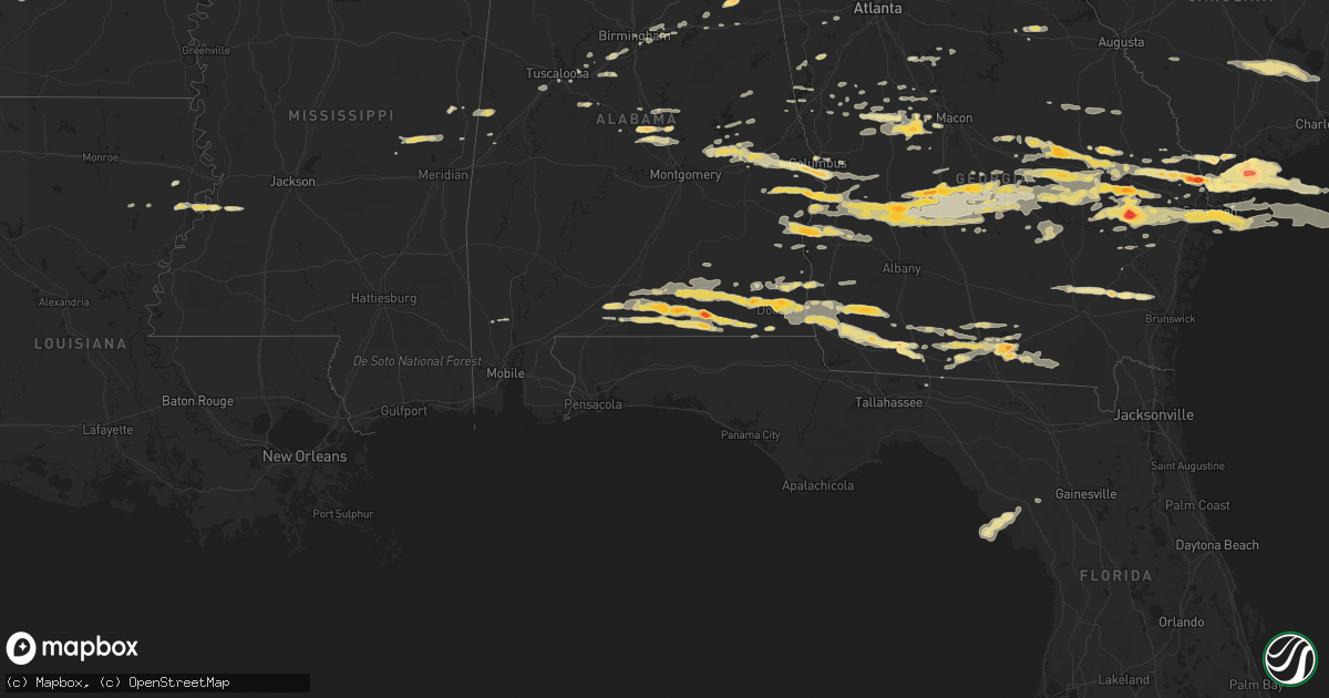
Hail Map in Georgia on March 27, 2011
Get this storm
March 27 map
$229
one time, instant access
Download today. No call, no setup
Keep the $229
Bought the map and want the full workflow? Apply the entire $229 to a subscription within 7 days. None of it is wasted.
Every map, not just this one
This buys you this map. Subscription and you get every map we run, in the markets you choose from a few cities to whole states to nationwide. Plus real-time alerts the moment a storm fires.
Contact data
Name, contact info, occupancy, even credit band for addresses in the footprint. You go from where it hit to who to call.
Become the source they trust
Unlimited branding weather history reports on demand. You already have the documented answer ready for the property owner, and you are the one who showed up with it.
Property data and RoofTrace estimates
Pull up any address you have got, its value and the exact code rules for that jurisdiction, straight from One Click Code. Then RoofTrace estimates the squares, pitch, and roof value, priced the way you price.
Storm reports in Georgia
Georgia
| Date | Description |
|---|---|
| 03/27/20116:23 PM CDT | Quarter size + hail reported |
| 03/27/20116:19 PM CDT | A local report indicates 1.00 inch wind near MOODY AFB |
| 03/27/20116:15 PM CDT | Quarter size hail and winds estimated between 40 and 50 mph. |
| 03/27/20116:15 PM CDT | A local report indicates 1.00 inch wind near THOMASVILLE |
| 03/27/20116:10 PM CDT | A local report indicates 1.00 inch wind near THOMASVILLE |
| 03/27/20115:47 PM CDT | A local report indicates 1.75 inch wind near CAIRO |
| 03/27/20115:40 PM CDT | A local report indicates 1.00 inch wind near CAIRO |
| 03/27/20115:22 PM CDT | Numerous trees down |
| 03/27/20115:01 PM CDT | A local report indicates 1.00 inch wind near 1 SW ELDORENDO |
| 03/27/20114:40 PM CDT | A local report indicates 1.25 inch wind near JAKIN |
| 03/27/20113:54 PM CDT | A local report indicates 1.00 inch wind near TYBEE ISLAND |
| 03/27/20113:52 PM CDT | Also reports numerous small branches down |
| 03/27/20113:47 PM CDT | A local report indicates 1.00 inch wind near WALTHOURVILLE |
| 03/27/20113:42 PM CDT | Public report of large hail. Also caused some window damage to house. |
| 03/27/20113:40 PM CDT | Pea to quarter size hail reported. |
| 03/27/20113:40 PM CDT | A local report indicates 1.00 inch wind near TYBEE ISLAND |
| 03/27/20113:36 PM CDT | 112 south tallahassee st nickel to quarter size hail |
| 03/27/20113:34 PM CDT | Spotter located on whitemarsh island. |
| 03/27/20113:30 PM CDT | Public report of quarter size hail breaking car windows. |
| 03/27/20113:30 PM CDT | A local report indicates 1.00 inch wind near THUNDERBOLT |
| 03/27/20113:27 PM CDT | A local report indicates 1.00 inch wind near 3 S REIDSVILLE |
| 03/27/20113:25 PM CDT | A local report indicates 1.00 inch wind near TYBEE ISLAND |
| 03/27/20113:20 PM CDT | Hail occurring between 420 and 430 pm. |
| 03/27/20113:18 PM CDT | Trained spotter report of half dollar size hail. |
| 03/27/20113:18 PM CDT | Piles of nickel to quarter size hail. |
| 03/27/20113:15 PM CDT | Quarter to half dollar size hail reported. |
| 03/27/20113:15 PM CDT | A local report indicates 1.75 inch wind near HOGGARD MILL |
| 03/27/20113:12 PM CDT | Quarter size hail near savannah memorial hospital. |
| 03/27/20113:10 PM CDT | A local report indicates 1.75 inch wind near THUNDERBOLT |
| 03/27/20113:08 PM CDT | Spotter had pea to ping pong ball size hail at residence. |
| 03/27/20113:08 PM CDT | A local report indicates 1.00 inch wind near WILMINGTON ISLAND |
| 03/27/20113:07 PM CDT | A local report indicates 2.00 inch wind near 2 NNE WILMINGTON ISLAND |
| 03/27/20113:07 PM CDT | A local report indicates 1.00 inch wind near WILMINGTON ISLAND |
| 03/27/20113:02 PM CDT | A local report indicates 1.00 inch wind near SAVANNAH |
| 03/27/20113:02 PM CDT | A local report indicates 1.00 inch wind near MOUNT VERNON |
| 03/27/20113:02 PM CDT | A local report indicates 1.25 inch wind near VIDALIA |
| 03/27/20112:55 PM CDT | A local report indicates 1.00 inch wind near 3 ESE GARDEN CITY |
| 03/27/20112:53 PM CDT | A local report indicates 1.75 inch wind near NAYLOR |
| 03/27/20112:25 PM CDT | Few trees down |
| 03/27/20112:15 PM CDT | A local report indicates 1.25 inch wind near RINCON |
| 03/27/20112:13 PM CDT | Public reported golf ball to baseball size hail and small limbs off trees. |
| 03/27/20112:12 PM CDT | Public reported golf ball size hail between guyton and rincon. |
| 03/27/20112:11 PM CDT | A local report indicates 1.25 inch wind near 4 N DAISY |
| 03/27/20112:10 PM CDT | A local report indicates 1.00 inch wind near 5 N EASTMAN |
| 03/27/20112:09 PM CDT | Dime to quarter size hail in rincon. |
| 03/27/20112:09 PM CDT | Hail covering ground. |
| 03/27/20112:08 PM CDT | Trained spotter reported quarter size hail. |
| 03/27/20112:05 PM CDT | A local report indicates 1.75 inch wind near 1 E RINCON |
| 03/27/20112:04 PM CDT | Golf ball to hen egg hail reported by cocorahs observer. |
| 03/27/20112:03 PM CDT | Public report of ping pong ball size hail for 2 minutes. Nnw winds 25 mph. |
| 03/27/20112:02 PM CDT | Hail covered ground. Dented cars and a camper. Leaves stripped off oak trees. |
| 03/27/20112:02 PM CDT | Spotter reported golf ball size hail. |
| 03/27/20112:00 PM CDT | A local report indicates 1.75 inch wind near PINEHURST |
| 03/27/20112:00 PM CDT | Quarter size hail in springfield. |
| 03/27/20112:00 PM CDT | A local report indicates 1.00 inch wind near RINCON |
| 03/27/20112:00 PM CDT | A local report indicates 2.50 inch wind near AMERICUS |
| 03/27/20112:00 PM CDT | A local report indicates 1.75 inch wind near BYROMVILLE |
| 03/27/20111:58 PM CDT | Golf ball size hail reported by the public. |
| 03/27/20111:57 PM CDT | A local report indicates 1.75 inch wind near AMERICUS |
| 03/27/20111:55 PM CDT | Quarter size hail covering the ground. |
| 03/27/20111:55 PM CDT | A local report indicates 1.75 inch wind near 5 S HAWKINSVILLE |
| 03/27/20111:55 PM CDT | A local report indicates 1.75 inch wind near AMERICUS |
| 03/27/20111:53 PM CDT | A local report indicates 2.00 inch wind near AMERICUS |
| 03/27/20111:51 PM CDT | Spotter was driving on hwy 57 between cobbtown and collins. |
| 03/27/20111:50 PM CDT | Spotter called back with larger hail now falling at his house. |
| 03/27/20111:50 PM CDT | A local report indicates 1.00 inch wind near BYROMVILLE |
| 03/27/20111:45 PM CDT | Numerous trees were reported down in hortense...including 2 large oak trees down on church road. |
| 03/27/20111:45 PM CDT | Pea to quarter size hail reported. |
| 03/27/20111:40 PM CDT | Spotter reported quarter size hail covering the ground. |
| 03/27/20111:40 PM CDT | Golf ball size hail lasted for 7 minutes and completely covered the ground. |
| 03/27/20111:38 PM CDT | A local report indicates 1.75 inch wind near GEORGETOWN |
| 03/27/20111:30 PM CDT | A local report indicates 1.00 inch wind near PRESTON |
| 03/27/20111:30 PM CDT | A local report indicates 1.00 inch wind near BROOKLET |
| 03/27/20111:24 PM CDT | A local report indicates 1.00 inch wind near 4 SSE STATESBORO |
| 03/27/20111:20 PM CDT | A local report indicates 1.00 inch wind near SOPERTON |
| 03/27/20111:15 PM CDT | Dispatch center relayed report of quarter size hail. |
| 03/27/20111:14 PM CDT | Spotter reported hail as large as quarters. |
| 03/27/20111:10 PM CDT | A local report indicates 1.00 inch wind near SOPERTON |
| 03/27/201112:55 PM CDT | One tree down on powerlines along clyo-kildare road. |
| 03/27/201112:53 PM CDT | A local report indicates 1.75 inch wind near 3 NW CAIRO |
| 03/27/201112:50 PM CDT | A local report indicates 1.00 inch wind near 6 E OMAHA |
| 03/27/201112:35 PM CDT | A local report indicates 1.75 inch wind near 4 WNW TWIN CITY |
| 03/27/201112:20 PM CDT | A local report indicates 1.75 inch wind near ADRIAN |
| 03/27/201112:18 PM CDT | A local report indicates 1.25 inch wind near ADRIAN |
| 03/27/201111:57 AM CDT | Sustained 40 mph...gust to 60 mph. |
| 03/27/201111:55 AM CDT | Several trees down |
| 03/27/201111:55 AM CDT | Several trees down on highway 319. |
| 03/27/201111:54 AM CDT | A local report indicates 1.00 inch wind near 1 SW TUCKERS CROSSROAD |
| 03/27/201110:50 AM CDT | A local report indicates 1.75 inch wind near 1 N ROBERTA |
| 03/27/201110:35 AM CDT | A local report indicates 1.00 inch wind near 2 S LIZELLA |
| 03/27/201110:10 AM CDT | At 341 and east hopewell road. |
| 03/27/20119:45 AM CDT | Widespread quarter size hail across the southern portion of the county...lasted at least 10 minutes. |
| 03/27/20119:05 AM CDT | Spotter reports nickle to quarter size hail that began at approx 1005 am edt but is now tapering off. |
| 03/27/20112:20 AM CDT | A local report indicates 1.00 inch wind near WINSTON |
| 03/26/201111:35 PM CDT | A local report indicates 1.00 inch wind near 1 E POWERS CROSSROADS |
| 03/26/201111:35 PM CDT | Quarter-sized hail reported by fort benning military police |
All States Impacted by Hail Map on March 27, 2011
Cities Impacted by Hail Map on March 27, 2011
- Woodbury, GA
- Gay, GA
- Molena, GA
- Umpire, AR
- Dierks, AR
- Tallulah, LA
- Musella, GA
- De Soto, GA
- Plains, GA
- Preston, GA
- Cobb, GA
- Smithville, GA
- Cordele, GA
- Richland, GA
- Leslie, GA
- Pitts, GA
- Americus, GA
- Abbeville, AL
- Columbia, AL
- Seale, AL
- Brent, AL
- Centreville, AL
- Georgetown, GA
- Eufaula, AL
- Beaufort, SC
- Springfield, GA
- Rincon, GA
- Newton, GA
- Camilla, GA
- Colquitt, GA
- Damascus, GA
- Leary, GA
- Cairo, GA
- Thorsby, AL
- Jemison, AL
- Newellton, LA
- Newnan, GA
- Little Rock, AR
- Savannah, GA
- Chester, GA
- Cochran, GA
- Metter, GA
- Daleville, AL
- Birmingham, AL
- Elko, GA
- Perry, GA
- Twin City, GA
- Hermanville, MS
- Utica, MS
- Port Gibson, MS
- Thomaston, GA
- Woodland, GA
- Gurdon, AR
- Fort Rucker, AL
- Elba, AL
- New Brockton, AL
- Newton, AL
- Enterprise, AL
- Opp, AL
- Kinston, AL
- Midland City, AL
- Nettleton, MS
- Verbena, AL
- Weaver, AL
- Jacksonville, AL
- Guyton, GA
- Plantersville, MS
- Shannon, MS
- Amory, MS
- Pontotoc, MS
- Houlka, MS
- Okolona, MS
- Port Royal, SC
- Saint Helena Island, SC
- Eastman, GA
- Vidalia, GA
- Lyons, GA
- Mount Vernon, GA
- Ailey, GA
- Hardeeville, SC
- Okatie, SC
- Bluffton, SC
- Hilton Head Island, SC
- England, AR
- Brunswick, GA
- Hortense, GA
- Patterson, GA
- Bessemer, AL
- McCalla, AL
- Dadeville, AL
- Headland, AL
- Naylor, GA
- Valdosta, GA
- Lake Park, GA
- Culloden, GA
- Ridgeland, SC
- Fort Stewart, GA
- Glennville, GA
- Claxton, GA
- Mantachie, MS
- Tupelo, MS
- Fulton, MS
- Mooreville, MS
- Gantt, AL
- Dothan, AL
- Andalusia, AL
- Webb, AL
- Ashford, AL
- Cowarts, AL
- Dozier, AL
- Notasulga, AL
- Tuskegee, AL
- Auburn, AL
- Chauncey, GA
- De Witt, AR
- Stuttgart, AR
- Altheimer, AR
- Star City, AR
- Sparkman, AR
- Carthage, AR
- Arkadelphia, AR
- Pine Bluff, AR
- Ivan, AR
- Fordyce, AR
- Yorktown, AR
- Gould, AR
- Grady, AR
- Kingsland, AR
- Rison, AR
- Pembroke, GA
- Hawkinsville, GA
- Emelle, AL
- Aliceville, AL
- Pavo, GA
- Moultrie, GA
- Butler, GA
- Knoxville, GA
- Roberta, GA
- Samson, AL
- Bloomingdale, GA
- Ellabell, GA
- Cuthbert, GA
- Midway, AL
- Morris, GA
- Clayton, AL
- Columbus, GA
- Fort Benning, GA
- Phenix City, AL
- Salem, AL
- Opelika, AL
- Chancellor, AL
- Brewton, AL
- Castleberry, AL
- Evergreen, AL
- Red Level, AL
- Florala, AL
- Geneva, AL
- Coffee Springs, AL
- Hartford, AL
- Slocomb, AL
- Lakeland, GA
- Morven, GA
- Dixie, GA
- Quitman, GA
- Hahira, GA
- Boston, GA
- Stockton, GA
- Barney, GA
- Smithville, MS
- Tallassee, AL
- Eclectic, AL
- Daviston, AL
- Alamo, GA
- Cadwell, GA
- Dublin, GA
- Rentz, GA
- Byromville, GA
- Weston, GA
- Abbeville, GA
- Rochelle, GA
- Unadilla, GA
- Pinehurst, GA
- Andersonville, GA
- Vienna, GA
- Montezuma, GA
- Reidsville, GA
- Collins, GA
- Tybee Island, GA
- Pooler, GA
- Richmond Hill, GA
- East Dublin, GA
- Swainsboro, GA
- Wrightsville, GA
- Adrian, GA
- Register, GA
- Statesboro, GA
- Tarrytown, GA
- Soperton, GA
- Glenwood, GA
- Rockledge, GA
- Prescott, AR
- Irwinton, GA
- Danville, GA
- Shellman, GA
- Lumpkin, GA
- Dawson, GA
- Meigs, GA
- Bonnerdale, AR
- Pearcy, AR
- Hot Springs National Park, AR
- Royal, AR
- Hensley, AR
- Old Town, FL
- Port Wentworth, GA
- North Little Rock, AR
- Hot Springs Village, AR
- Lonsdale, AR
- Coolidge, GA
- Allenhurst, GA
- Ludowici, GA
- Hinesville, GA
- Fosters, AL
- Ralph, AL
- Crawfordville, GA
- Scooba, MS
- Cusseta, GA
- Hurtsboro, AL
- Omaha, GA
- Pittsview, AL
- Hatchechubbee, AL
- Thomasville, GA
- Wadley, GA
- Bartow, GA
- Arcadia, FL
- Mabelvale, AR
- Statenville, GA
- Fargo, GA
- Moody Afb, GA
- Barwick, GA
- Du Pont, GA
- Vardaman, MS
- Pittsboro, MS
- Wetumpka, AL
- Newville, AL
- Alexandria, AL
- Wellington, AL
- Redfield, AR
- Blakely, GA
- Adel, GA
- Nashville, GA
- Ray City, GA
- Cobbtown, GA
- Brookwood, AL
- Shorterville, AL
- Citronelle, AL
- Sheridan, AR
- Shady Dale, GA
- Monticello, GA
- Anniston, AL
- Oxford, AL
- Eastaboga, AL
- Tuscaloosa, AL
- Brooklet, GA
- Macon, GA
- Piedmont, AL
- Lizella, GA
- Cottonwood, AL
- Caddo Gap, AR
- Greenville, GA
- Iron City, GA
- Whigham, GA
- Donalsonville, GA
- Ochlocknee, GA
- Jakin, GA
- Brinson, GA
- Gordon, AL
- Climax, GA
- Bainbridge, GA
- Horseshoe Beach, FL
- Billingsley, AL
- Prattville, AL
- Marbury, AL
- Deatsville, AL
- Garfield, GA
- Portal, GA
- Alexander, AR
- Alexander City, AL
- Tillman, SC
- Garnett, SC
- Stanton, AL
- Maplesville, AL
- Clanton, AL
- Trussville, AL
- Moody, AL
- Blackshear, GA
- Waycross, GA
- Mershon, GA
- Alma, GA
- Punta Gorda, FL
- Harleyville, SC
- Jesup, GA
- Benton, AR
- Livingston, AL
- Graceville, FL
- Bonifay, FL
- West Blocton, AL
- Hazlehurst, GA
- Trenton, FL
- Pine Mountain, GA
- Bauxite, AR
- Jessieville, AR
- Lanett, AL
- McRae Helena, GA
- Newington, GA
- Sylvania, GA
- Lumber City, GA
- Lincoln, AL
- Millen, GA
- Lonoke, AR
- Union, MS
- Philadelphia, MS
- Collinsville, MS
- De Kalb, MS
- Gillett, AR
- Camp Hill, AL
- Jackson, GA
- Locust Grove, GA
- Jenkinsburg, GA
- Bryant, AR
- Scott, AR
- Helena, AL
- Montevallo, AL
- Woodstock, AL
- Barnesville, GA
- Plainview, AR
- Lagrange, GA
- Carlisle, AR
- Rhine, GA
- Winfield, AL
- Brilliant, AL
- Ozark, AL
- Pineview, GA
- Malvern, AR
- Franklin, GA
- Union Springs, AL
- Monticello, FL
- Moncks Corner, SC
- Branchville, SC
- Cross, SC
- Dorchester, SC
- Bowman, SC
- Saint George, SC
- Summerville, SC
- Holly Hill, SC
- Ridgeville, SC
- Mountain Pine, AR
- Maumelle, AR
- Ohatchee, AL
- Okolona, AR
- Delight, AR
- Vance, MS
- Porterville, MS
- Shuqualak, MS
- Fort Mitchell, AL
- Traskwood, AR
- Leeds, AL
- Mansfield, GA
- Tuscumbia, AL
- Manchester, GA
- Five Points, AL
- Yatesville, GA
- Clyo, GA
- Rowesville, SC
- Cope, SC
- Reevesville, SC
- Forsyth, GA
- Daufuskie Island, SC
- Milan, GA
- Pell City, AL
- Reynolds, GA
- Pansey, AL
- Grannis, AR
- Wickes, AR
- Juliette, GA
- Belden, MS
- Winnsboro, LA
- Arlington, GA
- Murfreesboro, AR
- Milner, GA
- Detroit, AL
- Tremont, MS
- Greenwood Springs, MS
- Chiefland, FL
- Aberdeen, MS
- Fort Gaines, GA
- McIntosh, AL
- Mount Vernon, AL
- Buena Vista, GA
- Epes, AL
- Brantley, AL
- Jack, AL
- Mount Ida, AR
- Saltillo, MS
- Warm Springs, GA
- Weogufka, AL
- Zebulon, GA
- Williamson, GA
- Greensboro, GA
- Louisville, GA
- Midville, GA
- Talbotton, GA
- Byron, GA
- Clarksdale, MS
- Winston, GA
- Meansville, GA
- The Rock, GA
- Screven, GA
- Fort Valley, GA
- Pulaski, GA
- Kite, GA
- Davisboro, GA
- Sandersville, GA
- Cherokee, AL
- Surrency, GA
- Baxley, GA
- Williston, SC
- Pelham, GA
- New Albany, MS
- Cottondale, AL
- Glenwood, AL
- Millwood, GA
- Nicholls, GA
- Mena, AR
- Oglethorpe, GA
- Dexter, GA
- Baldwyn, MS
- Guntown, MS
- Tichnor, AR
- Alligator, MS
- Crumrod, AR
- Vance, AL
- West Point, GA
- Douglasville, GA
- Flovilla, GA
- Villa Rica, GA


