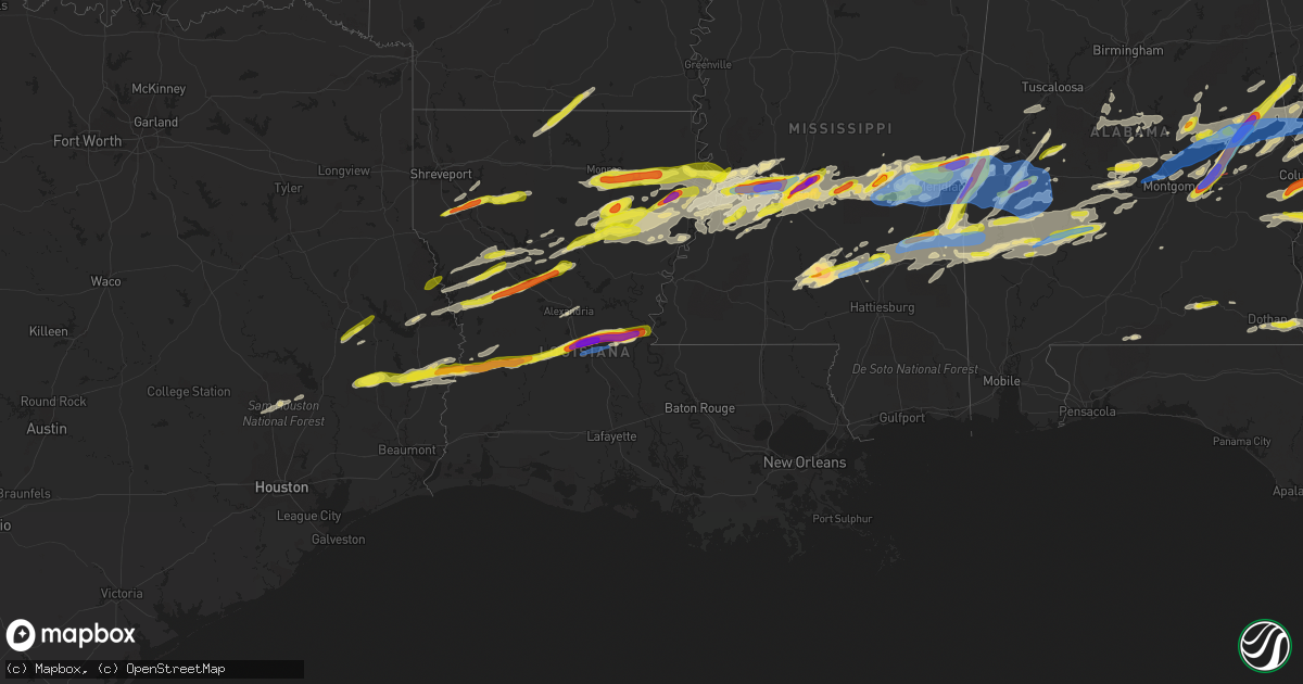
Hail Map in Louisiana on March 26, 2023
Get this storm
March 26 map
$229
one time, instant access
Download today. No call, no setup
Keep the $229
Bought the map and want the full workflow? Apply the entire $229 to a subscription within 7 days. None of it is wasted.
Every map, not just this one
This buys you this map. Subscription and you get every map we run, in the markets you choose from a few cities to whole states to nationwide. Plus real-time alerts the moment a storm fires.
Contact data
Name, contact info, occupancy, even credit band for addresses in the footprint. You go from where it hit to who to call.
Become the source they trust
Unlimited branding weather history reports on demand. You already have the documented answer ready for the property owner, and you are the one who showed up with it.
Property data and RoofTrace estimates
Pull up any address you have got, its value and the exact code rules for that jurisdiction, straight from One Click Code. Then RoofTrace estimates the squares, pitch, and roof value, priced the way you price.
Storm reports in Louisiana
Louisiana
| Date | Description |
|---|---|
| 03/26/20236:43 PM CDT | Quarter size hail reported on social media. |
| 03/26/20236:20 PM CDT | Dime to quarter size hail estimate from a gas station in olla. |
| 03/26/20236:19 PM CDT | Nickel to quarter size hail fell at the ouachita correctional center in richwood. |
| 03/26/20235:39 PM CDT | Quarter size hail fell near spearsville. |
| 03/26/20235:12 PM CDT | Damage to trees. Time estimated based on radar. |
| 03/26/20235:06 PM CDT | Multiple large trees snapped east of highway 71 along the banks of bayou boeuf. Time estimated off radar. |
| 03/26/20235:06 PM CDT | Chaser reports a mile long swath of telephone poles snapped off. |
| 03/26/20235:04 PM CDT | Em reports roof removed from manufactured home... Sheet metal thrown and damage to other homes. Time estimated by radar. Possible tornado. |
| 03/26/20235:00 PM CDT | Report of baseball size hail near cheneyville. |
| 03/26/20235:00 PM CDT | Quarter size hail reported by a gas station employee in the town of provencal. |
| 03/26/20234:32 PM CDT | Penny to quarter sized hail. |
| 03/26/20234:10 PM CDT | Report of tree down on hwy 26. Corroborated by local em. |
| 03/26/20234:05 PM CDT | Report from social media. |
| 03/26/20234:05 PM CDT | Report via social media. |
| 03/26/20234:04 PM CDT | Public reports two homes with roof damage in the same neighborhood. Video of funnel cloud were reported from this area at the time of damage. Possible tornado. |
| 03/26/20233:54 PM CDT | Report via social media. |
| 03/26/20233:30 PM CDT | Numerous reports and videos of 1 inch to 1.5 inch diameter hail. |
| 03/26/20233:30 PM CDT | A local report indicates 1.75 inch wind near 13 NW FORT NECESSITY |
| 03/26/20233:28 PM CDT | Quarter size hail fell at the dollar general in the hebert community. |
| 03/26/20233:05 PM CDT | Received from merryville truck stop. |
| 03/26/20232:54 PM CDT | Quarter size hail fell in many. |
| 03/26/20232:26 PM CDT | A local report indicates 1.00 inch wind near 1 NE LUCKY |
| 03/26/20232:19 PM CDT | A picture of nickel to quarter size hail that fell in castor was posted to social media. |
| 03/26/20232:08 PM CDT | Quarter size hail fell at springhill baptist church southwest of ringgold. |
| 03/25/20237:51 PM CDT | Report of a tree down on powerlines on highway 117. |
| 03/25/20237:40 PM CDT | A local report indicates 1.25 inch wind near 5 WSW WINNSBORO |
All States Impacted by Hail Map on March 26, 2023
Cities Impacted by Hail Map on March 26, 2023
- Eclectic, AL
- Equality, AL
- Selma, AL
- Jones, AL
- Alexander City, AL
- Autaugaville, AL
- Thomasville, AL
- Butler, AL
- Sweet Water, AL
- Prattville, AL
- Billingsley, AL
- Jacksons Gap, AL
- Dadeville, AL
- Harlem, GA
- Grovetown, GA
- Silas, AL
- Alberta, AL
- Minter, AL
- Stapleton, GA
- Warrenton, GA
- Thomson, GA
- Camden, AL
- Meansville, GA
- The Rock, GA
- Thomaston, GA
- Alcolu, SC
- Manning, SC
- Mitchell, GA
- Gibson, GA
- Sparta, GA
- Willis, TX
- Cades, SC
- Lake City, SC
- North Augusta, SC
- Graniteville, SC
- Dixons Mills, AL
- Arlington, AL
- Magnolia, AL
- Toxey, AL
- Pine Hill, AL
- Aiken, SC
- Wagener, SC
- Batesburg, SC
- Sumter, SC
- Pinewood, SC
- Dearing, GA
- Cleveland, TX
- Coldspring, TX
- Lake Waccamaw, NC
- Whiteville, NC
- Hallsboro, NC
- Bolton, NC
- Marbury, AL
- Deatsville, AL
- Warthen, GA
- Norwood, GA
- Catherine, AL
- Camp Hill, AL
- Waynesboro, MS
- Saint Matthews, SC
- Needham, AL
- Thomaston, AL
- Gilbertown, AL
- New Zion, SC
- Waverly, AL
- New Waverly, TX
- Forsyth, GA
- Plantersville, AL
- Corrigan, TX
- Lufkin, TX
- Diboll, TX
- Huntington, TX
- Zavalla, TX
- Woodville, TX
- Warren, TX
- Livingston, TX
- Hillister, TX
- Grand Cane, LA
- Mansfield, LA
- Shreveport, LA
- Coushatta, LA
- Spurger, TX
- Kirbyville, TX
- Jasper, TX
- Elm Grove, LA
- Ringgold, LA
- Milam, TX
- Zwolle, LA
- Fred, TX
- Castor, LA
- Bienville, LA
- Quitman, LA
- Newton, TX
- Elba, AL
- New Brockton, AL
- Bon Wier, TX
- Saline, LA
- Merryville, LA
- Burkeville, TX
- Florien, LA
- Hornbeck, LA
- Enterprise, AL
- Deridder, LA
- Provencal, LA
- Winnsboro, LA
- Delhi, LA
- Tallulah, LA
- Seale, AL
- Phenix City, AL
- Fort Mitchell, AL
- Sugartown, LA
- Cloutierville, LA
- Lena, LA
- Fort Benning, GA
- Columbus, GA
- Pittsview, AL
- Eufaula, AL
- Columbia, LA
- Rayville, LA
- Mangham, LA
- Colfax, LA
- Dry Prong, LA
- Dry Creek, LA
- Grant, LA
- Pitkin, LA
- Oakdale, LA
- Elizabeth, LA
- Georgetown, LA
- Box Springs, GA
- Omaha, GA
- Lumpkin, GA
- Vicksburg, MS
- Lake, MS
- Forest, MS
- Glenmora, LA
- Pollock, LA
- Conehatta, MS
- Edwards, MS
- Upatoi, GA
- Ville Platte, LA
- Forest Hill, LA
- Lawrence, MS
- Decatur, MS
- Richland, GA
- Cheneyville, LA
- Lecompte, LA
- Bolton, MS
- Clinton, MS
- Jackson, MS
- Flowood, MS
- Bunkie, LA
- Hessmer, LA
- Natchitoches, LA
- Robeline, LA
- Many, LA
- Ridgeland, MS
- Pearl, MS
- Collinsville, MS
- Little Rock, MS
- Raymond, MS
- Tougaloo, MS
- Madison, MS
- Brandon, MS
- Richland, MS
- Saint Landry, LA
- Evergreen, LA
- Cottonport, LA
- Utica, MS
- Terry, MS
- Byram, MS
- Port Gibson, MS
- Hermanville, MS
- Mansura, LA
- Moreauville, LA
- Simmesport, LA
- Marksville, LA
- Spearsville, LA
- Lillie, LA
- Peotone, IL
- Minooka, IL
- Monee, IL
- University Park, IL
- Wisner, LA
- Gilbert, LA
- Sicily Island, LA
- Morris, IL
- Yorkville, IL
- Millington, IL
- Sheridan, IL
- Newark, IL
- Marthaville, LA
- Homer, LA
- Bernice, LA
- West Monroe, LA
- Shorewood, IL
- Plainfield, IL
- Joliet, IL
- Pineland, TX
- Earlville, IL
- Serena, IL
- Ottawa, IL
- Wing, AL
- Alexandria, LA
- Hatchechubbee, AL
- McDavid, FL
- Midway, AL
- Romeoville, IL
- Grove Hill, AL
- Kinston, AL
- Jamestown, LA
- Harrisonburg, LA
- Fort Necessity, LA
- Enterprise, LA
- Anacoco, LA
- Pineville, LA
- Atlanta, LA
- Leesville, LA
- Rosepine, LA
- Belmont, LA
- Honoraville, AL
- Greenville, AL
- Grayson, LA
- Chester, TX
- Jay, FL
- Orrville, AL
- Bronson, TX
- Peru, IL
- La Salle, IL
- Dalzell, IL
- Arlington, IL
- Montgomery, LA
- Coffeeville, AL
- Kelly, LA
- Hemphill, TX
- Opp, AL
- Newellton, LA
- Andalusia, AL
- Olla, LA
- Brewton, AL
- Oswego, IL
- Saint Joseph, LA
- Natchez, LA
- Winnfield, LA
- Call, TX
- Fort Rucker, AL
- Daleville, AL
- Ashford, AL
- Dothan, AL
- Cowarts, AL
- Pansey, AL
- Pike Road, AL
- Cecil, AL
- Montgomery, AL
- Shorter, AL
- Tuskegee, AL
- Tallassee, AL
- Notasulga, AL
- Dyer, IN
- Saint John, IN
- Crete, IL
- Cedar Lake, IN
- Crown Point, IN
- Beecher, IL
- Lena, MS
- Pelahatchie, MS
- Morton, MS
- Manhattan, IL
- Wilmington, IL
- Manteno, IL
- Meridian, MS
- Bailey, MS
- Daleville, MS
- Lauderdale, MS
- Porterville, MS
- De Kalb, MS
- Cuba, AL
- Livingston, AL
- York, AL
- Monterey, LA
- Quitman, MS
- Newton, MS
- Louin, MS
- Raleigh, MS
- Lisman, AL
- Toomsuba, MS
- Ward, AL
- Hickory, MS
- Rose Hill, MS
- Chunky, MS
- Enterprise, MS
- Strong, AR
- Monroe, LA
- Prentiss, MS
- Collins, MS
- Baskin, LA
- Redwood, MS
- Heidelberg, MS
- Laurel, MS
- Vossburg, MS
- Shubuta, MS
- Tullos, LA
- Marion, MS
- Pachuta, MS
- Taylorsville, MS
- Lafayette, AL
- Five Points, AL
- Lower Peach Tree, AL
- Kellyton, AL
- Rockford, AL
- Coy, AL
- Roanoke, AL
- Newbern, AL
- Greensboro, AL
- Gallion, AL
- Marion, AL
- Pennington, AL
- Demopolis, AL
- Linden, AL
- Soso, MS
- Ellisville, MS
- Melvin, AL
- Epes, AL
- Sondheimer, LA
- Valley Park, MS
- Pine Apple, AL
- Jachin, AL
- Bellamy, AL
- Boligee, AL
- Franklin, GA
- Utica, IL
- Hogansville, GA
- Newnan, GA
- Sandwich, IL
- Grantville, GA
- Rutledge, GA
- Madison, GA
- Sharpsburg, GA
- Forkland, AL
- Palmetto, GA
- Tyrone, GA
- Fairburn, GA
- Union City, GA
- Lockport, IL
- Atlanta, GA
- Red Oak, GA
- Faunsdale, AL
- Uniontown, AL
- Norcross, GA
- Tucker, GA
- Lilburn, GA
- Lawrenceville, GA
- Duluth, GA
- Monetta, SC
- Trenton, SC
- Ridge Spring, SC
- Johnston, SC
- Leesville, SC
- Pelion, SC
- Lowndesboro, AL
- Millbrook, AL
- Elmore, AL
- Coosada, AL
- Wetumpka, AL
- Titus, AL
- Mize, MS
- Goodwater, AL
- Millerville, AL
- Union, MS
- Mcdonough, GA
- Covington, GA
- Mount Olive, MS
- Chappells, SC
- Decatur, GA
- Wadley, AL
- Seminary, MS
- Newhebron, MS
- Auburn, AL
- Evans, GA
- Clarks Hill, SC
- Pine Mountain, GA
- West Point, GA
- Augusta, GA
- Lagrange, GA
- Opelika, AL
- Lanett, AL
- Cusseta, AL
- Valley, AL
- Carlton, GA
- Lexington, GA
- Rayle, GA
- Stephens, GA
- Flora, MS
- Edgefield, SC
- Plum Branch, SC
- Modoc, SC
- Waverly Hall, GA
- Montevallo, AL
- Centreville, AL
- Silver Creek, MS
- Monticello, MS
- Fitzpatrick, AL
- Ellerslie, GA
- Cataula, GA
- Huttig, AR
- Talbotton, GA
- Junction City, GA
- Bay Springs, MS
- Tyler, AL
- Sardis, AL
- Hamilton, GA
- Salem, AL
- Fortson, GA
- Smiths Station, AL
- Gordon, AL
- Jakin, GA
- Columbia, AL
- Warm Springs, GA
- Greenville, GA
- Magee, MS
- Carson, MS
- Oak Vale, MS
- Barnesville, GA
- Fayetteville, GA
- Slocomb, AL
- Pulaski, MS
- Waterproof, LA
- Blakely, GA
- Sikes, LA
- Akron, AL
- Newborn, GA
- Walnut Grove, MS
- Bentonia, MS
- Crystal Springs, MS
- Florence, MS
- Sawyerville, AL
- Plaucheville, LA
- Maplesville, AL
- Millry, AL
- Eros, LA
- Moreland, GA
- Peachtree City, GA
- Stringer, MS
- Sontag, MS
- Jayess, MS
- Dickinson, AL
- Swansea, SC
- Spring Valley, IL
- Ladd, IL
- Wedgefield, SC
- Eastover, SC
- Kinards, SC
- Silverstreet, SC
- Senoia, GA
- Jackson, GA
- Alpharetta, GA
- Peachtree Corners, GA
- Marietta, GA
- Greensboro, GA
- Buckhead, GA
- Philadelphia, MS
- Gay, GA
- Douglasville, GA
- Mathews, AL
- Williamson, GA
- Griffin, GA
- Concord, GA
- Orangeburg, SC
- Cameron, SC
- Wedowee, AL
- Salley, SC
- North, SC
- Gaston, SC
- Ward, SC
- Molena, GA
- Hurtsboro, AL
- Flowery Branch, GA
- Buford, GA
- Talladega, AL
- Jewell, GA
- Campbell, AL
- Hayneville, AL
- Suwanee, GA
- Clanton, AL
- McCormick, SC
- Clayton, LA
- Oak Ridge, LA
- Moundville, AL
- Emelle, AL
- Canton, MS
- Macon, GA
- Gray, GA
- Woodbury, GA
- Manchester, GA
- Southport, NC
- Bolivia, NC
- Randolph, AL
- Thorsby, AL
- Daviston, AL
- Brierfield, AL
- Whitesburg, GA
- Lawley, AL
- Jemison, AL
- Weogufka, AL
- Roberta, GA
- Juliette, GA
- Musella, GA
- Pine Mountain Valley, GA
- Hardaway, AL
- Reynolds, GA
- Marion Junction, AL
- Fosters, AL
- Knoxville, AL
- Ralph, AL
- Snellville, GA
- Grayson, GA
- Roswell, GA
- Gordon, GA
- Culloden, GA
- Merrillville, IN


