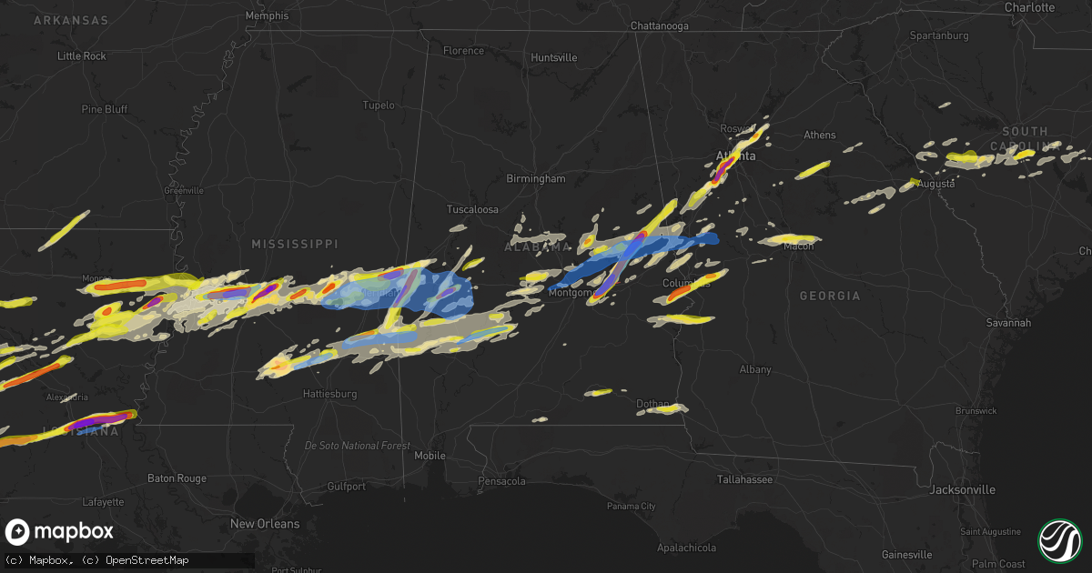
Hail Map in Alabama on March 26, 2023
Get this storm
March 26 map
$229
one time, instant access
Download today. No call, no setup
Keep the $229
Bought the map and want the full workflow? Apply the entire $229 to a subscription within 7 days. None of it is wasted.
Every map, not just this one
This buys you this map. Subscription and you get every map we run, in the markets you choose from a few cities to whole states to nationwide. Plus real-time alerts the moment a storm fires.
Contact data
Name, contact info, occupancy, even credit band for addresses in the footprint. You go from where it hit to who to call.
Become the source they trust
Unlimited branding weather history reports on demand. You already have the documented answer ready for the property owner, and you are the one who showed up with it.
Property data and RoofTrace estimates
Pull up any address you have got, its value and the exact code rules for that jurisdiction, straight from One Click Code. Then RoofTrace estimates the squares, pitch, and roof value, priced the way you price.
Storm reports in Alabama
Alabama
| Date | Description |
|---|---|
| 03/26/20236:57 PM CDT | A local report indicates 1.50 inch wind near 1 SW LIVINGSTON |
| 03/26/20236:47 PM CDT | Social media image of hail estimated at golf ball size. |
| 03/26/20236:46 PM CDT | Social media image of hail near boyd. |
| 03/26/20236:36 PM CDT | Corrects previous hail report from cuba. |
| 03/26/20236:36 PM CDT | A local report indicates 1.50 inch wind near CUBA |
| 03/26/20236:25 PM CDT | A barn and large portable storage building destroyed on kelly road. A home had minor damage just to the west on sandflat rd. |
| 03/26/20236:24 PM CDT | Emergency manager reports billboard signs and traffic signals down at highway 43 and north clark industrial road. |
| 03/26/20236:22 PM CDT | Emergency manager reports multiple trees down... Minor structural damage to a mobile home... And small debris in the general vicinity of sandflat road and london road. |
| 03/26/20236:18 PM CDT | Quarter size hail reported on tallahatta spring rd at huggins rd. |
| 03/26/20236:06 PM CDT | Social media hail picture of large hail estimated at 2 inches near elam baptist church. |
| 03/26/20236:01 PM CDT | A large tree was blown down and smashed a shop building. |
| 03/26/20236:00 PM CDT | The front porch and part of the roof was blown off a home. |
| 03/26/20235:50 PM CDT | A local report indicates 1.50 inch wind near 1 N SHORTER |
| 03/26/20235:50 PM CDT | Significant amount of quarter size hail reported in west bend. |
| 03/26/20235:33 PM CDT | Quarter size hail at the water in pike road. |
| 03/26/20235:30 PM CDT | Houston county 911 reports several trees down around the hodgesville area. |
| 03/26/20235:06 PM CDT | Em reports large tree down blocking hwy 84 in isney... Al. Time using radar. |
| 03/26/20233:48 PM CDT | At least quarter size hail in phenix city. |
| 03/26/20233:46 PM CDT | A local report indicates 1.25 inch wind near 1 E FORT MITCHELL |
| 03/26/20233:33 PM CDT | Lots of hail falling over seale. Some of the hail was at least quarter size. |
| 03/26/20232:29 PM CDT | Coffee co 911 reports a couple of power lines down on hwy 141. |
| 03/26/20231:12 PM CDT | Em reports hail ranging in size from dime to quarter. Time using radar. |
| 03/26/202310:28 AM CDT | Multiple trees down blocking roadways south of lake martin... Including turner road... Lakewood drive... Center port road... And overlook drive. |
| 03/26/20237:46 AM CDT | Part of the metal roof was blown off a house near hoboken. |
| 03/26/20237:23 AM CDT | Social media report of hail in vida junction. |
| 03/26/20237:20 AM CDT | Social media report of golf ball size hail near wind creek. Time estimated via radar. |
| 03/26/20237:18 AM CDT | Trees down county road 9 and 45. |
| 03/25/202310:28 PM CDT | Corrects time for previous tstm wnd dmg report from 2 sw still waters resort. Multiple trees down blocking roadways south of lake martin... Including turner road... Lak |
| 03/25/202310:24 PM CDT | Multiple trees down near red hill including near highway 229 and county 359 and camp talisi road and holley mill road. |
| 03/25/20239:57 PM CDT | Trees blown down near georgia road and tallassee hwy. |
| 03/25/20239:57 PM CDT | Trees down blocking the roadway near holtville road and crenshaw road. |
| 03/25/20239:56 PM CDT | Trees blown down on shadow wood lane. |
| 03/25/20239:51 PM CDT | Trees blown down near hogan road and hwy 43. |
| 03/25/20239:51 PM CDT | Corrects previous tstm wnd dmg report from speigner. Trees blown down near hogan road and hwy 143. |
| 03/25/20239:50 PM CDT | Tree on house. |
| 03/25/20239:48 PM CDT | Tree on house and trees down on quail run rd. |
| 03/25/20239:48 PM CDT | Powerlines down. |
| 03/25/20239:45 PM CDT | Tree blocking road. |
| 03/25/20239:45 PM CDT | Multiple trees were blown down on airport road near meadowlane. |
| 03/25/20239:45 PM CDT | Tree down... Damaged building and powerlines at prattville pickers. |
| 03/25/20239:42 PM CDT | Numerous trees blown around prattville. |
| 03/25/20239:40 PM CDT | Tree on gas line and house. |
| 03/25/20239:39 PM CDT | Trees and powerlines down along with at least minor structural damage. Possible tornado. |
| 03/25/20239:28 PM CDT | Corrects previous tstm wnd dmg report from 3 wnw autaugaville. Corrects previous tstm wnd dmg report from 3 wnw autaugaville. A tree was blown down and was blocking the |
| 03/25/20239:18 PM CDT | Media reports through nwschat quarter hail in fulton... Al. |
| 03/25/20238:54 PM CDT | Tree down on county road 955. |
| 03/25/20238:51 PM CDT | Trees down on round hill road approximately 3 miles east of old highway 5. |
| 03/25/20238:34 PM CDT | Several trees snapped and roof removed from a manufactured home near iris road and county 14 in the flatwood community. |
| 03/25/20237:58 PM CDT | Trees were blown down and blocking the road near cr 21 and lilita road. |
| 03/25/20237:45 PM CDT | County ema reports multiple trees down across choctaw county with roads blocked. Widespread power outage reported in butler. |
| 03/25/20237:40 PM CDT | Power lines down on riderwood dr at scott mountain rd. |
| 03/25/20237:30 PM CDT | Trees blocking highway 10... One mile east of hwy 28 split. |
| 03/25/20237:25 PM CDT | Quarter size hail on highway 10... East of the highway 41 interchange. Power flashes also reported in the area. |
| 03/25/20237:15 PM CDT | A local report indicates 1.00 inch wind near ROCKFORD |
| 03/25/20237:10 PM CDT | Estimated 2 in diameter hail from fire dept pic. |
| 03/25/20237:00 PM CDT | Social media image of quarter size hail. |
All States Impacted by Hail Map on March 26, 2023
Cities Impacted by Hail Map on March 26, 2023
- Eclectic, AL
- Equality, AL
- Selma, AL
- Jones, AL
- Alexander City, AL
- Autaugaville, AL
- Thomasville, AL
- Butler, AL
- Sweet Water, AL
- Prattville, AL
- Billingsley, AL
- Jacksons Gap, AL
- Dadeville, AL
- Harlem, GA
- Grovetown, GA
- Silas, AL
- Alberta, AL
- Minter, AL
- Stapleton, GA
- Warrenton, GA
- Thomson, GA
- Camden, AL
- Meansville, GA
- The Rock, GA
- Thomaston, GA
- Alcolu, SC
- Manning, SC
- Mitchell, GA
- Gibson, GA
- Sparta, GA
- Willis, TX
- Cades, SC
- Lake City, SC
- North Augusta, SC
- Graniteville, SC
- Dixons Mills, AL
- Arlington, AL
- Magnolia, AL
- Toxey, AL
- Pine Hill, AL
- Aiken, SC
- Wagener, SC
- Batesburg, SC
- Sumter, SC
- Pinewood, SC
- Dearing, GA
- Cleveland, TX
- Coldspring, TX
- Lake Waccamaw, NC
- Whiteville, NC
- Hallsboro, NC
- Bolton, NC
- Marbury, AL
- Deatsville, AL
- Warthen, GA
- Norwood, GA
- Catherine, AL
- Camp Hill, AL
- Waynesboro, MS
- Saint Matthews, SC
- Needham, AL
- Thomaston, AL
- Gilbertown, AL
- New Zion, SC
- Waverly, AL
- New Waverly, TX
- Forsyth, GA
- Plantersville, AL
- Corrigan, TX
- Lufkin, TX
- Diboll, TX
- Huntington, TX
- Zavalla, TX
- Woodville, TX
- Warren, TX
- Livingston, TX
- Hillister, TX
- Grand Cane, LA
- Mansfield, LA
- Shreveport, LA
- Coushatta, LA
- Spurger, TX
- Kirbyville, TX
- Jasper, TX
- Elm Grove, LA
- Ringgold, LA
- Milam, TX
- Zwolle, LA
- Fred, TX
- Castor, LA
- Bienville, LA
- Quitman, LA
- Newton, TX
- Elba, AL
- New Brockton, AL
- Bon Wier, TX
- Saline, LA
- Merryville, LA
- Burkeville, TX
- Florien, LA
- Hornbeck, LA
- Enterprise, AL
- Deridder, LA
- Provencal, LA
- Winnsboro, LA
- Delhi, LA
- Tallulah, LA
- Seale, AL
- Phenix City, AL
- Fort Mitchell, AL
- Sugartown, LA
- Cloutierville, LA
- Lena, LA
- Fort Benning, GA
- Columbus, GA
- Pittsview, AL
- Eufaula, AL
- Columbia, LA
- Rayville, LA
- Mangham, LA
- Colfax, LA
- Dry Prong, LA
- Dry Creek, LA
- Grant, LA
- Pitkin, LA
- Oakdale, LA
- Elizabeth, LA
- Georgetown, LA
- Box Springs, GA
- Omaha, GA
- Lumpkin, GA
- Vicksburg, MS
- Lake, MS
- Forest, MS
- Glenmora, LA
- Pollock, LA
- Conehatta, MS
- Edwards, MS
- Upatoi, GA
- Ville Platte, LA
- Forest Hill, LA
- Lawrence, MS
- Decatur, MS
- Richland, GA
- Cheneyville, LA
- Lecompte, LA
- Bolton, MS
- Clinton, MS
- Jackson, MS
- Flowood, MS
- Bunkie, LA
- Hessmer, LA
- Natchitoches, LA
- Robeline, LA
- Many, LA
- Ridgeland, MS
- Pearl, MS
- Collinsville, MS
- Little Rock, MS
- Raymond, MS
- Tougaloo, MS
- Madison, MS
- Brandon, MS
- Richland, MS
- Saint Landry, LA
- Evergreen, LA
- Cottonport, LA
- Utica, MS
- Terry, MS
- Byram, MS
- Port Gibson, MS
- Hermanville, MS
- Mansura, LA
- Moreauville, LA
- Simmesport, LA
- Marksville, LA
- Spearsville, LA
- Lillie, LA
- Peotone, IL
- Minooka, IL
- Monee, IL
- University Park, IL
- Wisner, LA
- Gilbert, LA
- Sicily Island, LA
- Morris, IL
- Yorkville, IL
- Millington, IL
- Sheridan, IL
- Newark, IL
- Marthaville, LA
- Homer, LA
- Bernice, LA
- West Monroe, LA
- Shorewood, IL
- Plainfield, IL
- Joliet, IL
- Pineland, TX
- Earlville, IL
- Serena, IL
- Ottawa, IL
- Wing, AL
- Alexandria, LA
- Hatchechubbee, AL
- McDavid, FL
- Midway, AL
- Romeoville, IL
- Grove Hill, AL
- Kinston, AL
- Jamestown, LA
- Harrisonburg, LA
- Fort Necessity, LA
- Enterprise, LA
- Anacoco, LA
- Pineville, LA
- Atlanta, LA
- Leesville, LA
- Rosepine, LA
- Belmont, LA
- Honoraville, AL
- Greenville, AL
- Grayson, LA
- Chester, TX
- Jay, FL
- Orrville, AL
- Bronson, TX
- Peru, IL
- La Salle, IL
- Dalzell, IL
- Arlington, IL
- Montgomery, LA
- Coffeeville, AL
- Kelly, LA
- Hemphill, TX
- Opp, AL
- Newellton, LA
- Andalusia, AL
- Olla, LA
- Brewton, AL
- Oswego, IL
- Saint Joseph, LA
- Natchez, LA
- Winnfield, LA
- Call, TX
- Fort Rucker, AL
- Daleville, AL
- Ashford, AL
- Dothan, AL
- Cowarts, AL
- Pansey, AL
- Pike Road, AL
- Cecil, AL
- Montgomery, AL
- Shorter, AL
- Tuskegee, AL
- Tallassee, AL
- Notasulga, AL
- Dyer, IN
- Saint John, IN
- Crete, IL
- Cedar Lake, IN
- Crown Point, IN
- Beecher, IL
- Lena, MS
- Pelahatchie, MS
- Morton, MS
- Manhattan, IL
- Wilmington, IL
- Manteno, IL
- Meridian, MS
- Bailey, MS
- Daleville, MS
- Lauderdale, MS
- Porterville, MS
- De Kalb, MS
- Cuba, AL
- Livingston, AL
- York, AL
- Monterey, LA
- Quitman, MS
- Newton, MS
- Louin, MS
- Raleigh, MS
- Lisman, AL
- Toomsuba, MS
- Ward, AL
- Hickory, MS
- Rose Hill, MS
- Chunky, MS
- Enterprise, MS
- Strong, AR
- Monroe, LA
- Prentiss, MS
- Collins, MS
- Baskin, LA
- Redwood, MS
- Heidelberg, MS
- Laurel, MS
- Vossburg, MS
- Shubuta, MS
- Tullos, LA
- Marion, MS
- Pachuta, MS
- Taylorsville, MS
- Lafayette, AL
- Five Points, AL
- Lower Peach Tree, AL
- Kellyton, AL
- Rockford, AL
- Coy, AL
- Roanoke, AL
- Newbern, AL
- Greensboro, AL
- Gallion, AL
- Marion, AL
- Pennington, AL
- Demopolis, AL
- Linden, AL
- Soso, MS
- Ellisville, MS
- Melvin, AL
- Epes, AL
- Sondheimer, LA
- Valley Park, MS
- Pine Apple, AL
- Jachin, AL
- Bellamy, AL
- Boligee, AL
- Franklin, GA
- Utica, IL
- Hogansville, GA
- Newnan, GA
- Sandwich, IL
- Grantville, GA
- Rutledge, GA
- Madison, GA
- Sharpsburg, GA
- Forkland, AL
- Palmetto, GA
- Tyrone, GA
- Fairburn, GA
- Union City, GA
- Lockport, IL
- Atlanta, GA
- Red Oak, GA
- Faunsdale, AL
- Uniontown, AL
- Norcross, GA
- Tucker, GA
- Lilburn, GA
- Lawrenceville, GA
- Duluth, GA
- Monetta, SC
- Trenton, SC
- Ridge Spring, SC
- Johnston, SC
- Leesville, SC
- Pelion, SC
- Lowndesboro, AL
- Millbrook, AL
- Elmore, AL
- Coosada, AL
- Wetumpka, AL
- Titus, AL
- Mize, MS
- Goodwater, AL
- Millerville, AL
- Union, MS
- Mcdonough, GA
- Covington, GA
- Mount Olive, MS
- Chappells, SC
- Decatur, GA
- Wadley, AL
- Seminary, MS
- Newhebron, MS
- Auburn, AL
- Evans, GA
- Clarks Hill, SC
- Pine Mountain, GA
- West Point, GA
- Augusta, GA
- Lagrange, GA
- Opelika, AL
- Lanett, AL
- Cusseta, AL
- Valley, AL
- Carlton, GA
- Lexington, GA
- Rayle, GA
- Stephens, GA
- Flora, MS
- Edgefield, SC
- Plum Branch, SC
- Modoc, SC
- Waverly Hall, GA
- Montevallo, AL
- Centreville, AL
- Silver Creek, MS
- Monticello, MS
- Fitzpatrick, AL
- Ellerslie, GA
- Cataula, GA
- Huttig, AR
- Talbotton, GA
- Junction City, GA
- Bay Springs, MS
- Tyler, AL
- Sardis, AL
- Hamilton, GA
- Salem, AL
- Fortson, GA
- Smiths Station, AL
- Gordon, AL
- Jakin, GA
- Columbia, AL
- Warm Springs, GA
- Greenville, GA
- Magee, MS
- Carson, MS
- Oak Vale, MS
- Barnesville, GA
- Fayetteville, GA
- Slocomb, AL
- Pulaski, MS
- Waterproof, LA
- Blakely, GA
- Sikes, LA
- Akron, AL
- Newborn, GA
- Walnut Grove, MS
- Bentonia, MS
- Crystal Springs, MS
- Florence, MS
- Sawyerville, AL
- Plaucheville, LA
- Maplesville, AL
- Millry, AL
- Eros, LA
- Moreland, GA
- Peachtree City, GA
- Stringer, MS
- Sontag, MS
- Jayess, MS
- Dickinson, AL
- Swansea, SC
- Spring Valley, IL
- Ladd, IL
- Wedgefield, SC
- Eastover, SC
- Kinards, SC
- Silverstreet, SC
- Senoia, GA
- Jackson, GA
- Alpharetta, GA
- Peachtree Corners, GA
- Marietta, GA
- Greensboro, GA
- Buckhead, GA
- Philadelphia, MS
- Gay, GA
- Douglasville, GA
- Mathews, AL
- Williamson, GA
- Griffin, GA
- Concord, GA
- Orangeburg, SC
- Cameron, SC
- Wedowee, AL
- Salley, SC
- North, SC
- Gaston, SC
- Ward, SC
- Molena, GA
- Hurtsboro, AL
- Flowery Branch, GA
- Buford, GA
- Talladega, AL
- Jewell, GA
- Campbell, AL
- Hayneville, AL
- Suwanee, GA
- Clanton, AL
- McCormick, SC
- Clayton, LA
- Oak Ridge, LA
- Moundville, AL
- Emelle, AL
- Canton, MS
- Macon, GA
- Gray, GA
- Woodbury, GA
- Manchester, GA
- Southport, NC
- Bolivia, NC
- Randolph, AL
- Thorsby, AL
- Daviston, AL
- Brierfield, AL
- Whitesburg, GA
- Lawley, AL
- Jemison, AL
- Weogufka, AL
- Roberta, GA
- Juliette, GA
- Musella, GA
- Pine Mountain Valley, GA
- Hardaway, AL
- Reynolds, GA
- Marion Junction, AL
- Fosters, AL
- Knoxville, AL
- Ralph, AL
- Snellville, GA
- Grayson, GA
- Roswell, GA
- Gordon, GA
- Culloden, GA
- Merrillville, IN


