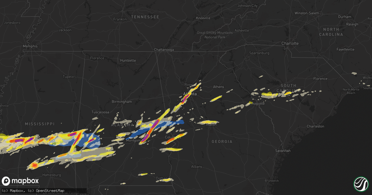
Hail Map on March 26, 2023
Get this storm
March 26 map
$229
one time, instant access
Download today. No call, no setup
Keep the $229
Bought the map and want the full workflow? Apply the entire $229 to a subscription within 7 days. None of it is wasted.
Every map, not just this one
This buys you this map. Subscription and you get every map we run, in the markets you choose from a few cities to whole states to nationwide. Plus real-time alerts the moment a storm fires.
Contact data
Name, contact info, occupancy, even credit band for addresses in the footprint. You go from where it hit to who to call.
Become the source they trust
Unlimited branding weather history reports on demand. You already have the documented answer ready for the property owner, and you are the one who showed up with it.
Property data and RoofTrace estimates
Pull up any address you have got, its value and the exact code rules for that jurisdiction, straight from One Click Code. Then RoofTrace estimates the squares, pitch, and roof value, priced the way you price.
States Impacted by Hail Map on March 26, 2023
Storm reports
Texas
| Date | Description |
|---|---|
| 03/26/20232:25 PM CDT | Tree down across hwy 96. |
North Carolina
| Date | Description |
|---|---|
| 03/26/20233:01 AM CDT | Camper overturned. Tree damage. Possible tornado. Storm survey team en route. Time estimated by radar. |
| 03/26/20232:59 AM CDT | This corrects the previous local storm report for 4 se longwood issued at 1001 am. Damage included an overturned camper... Roof damage to a shed... And tree damage. |
| 03/26/20231:00 AM CDT | Moore county 911 passed along a public report of a couple of trees down in the pasture by their pond. |
South Carolina
| Date | Description |
|---|---|
| 03/26/202310:12 AM CDT | Em reported tree on powerline at north brewington road and barnhill lane. |
| 03/26/202310:05 AM CDT | Dispatch reported multiple trees and power lines down around park on racoon rd in manning. |
| 03/26/202310:00 AM CDT | Em reported powerline down at highway 260 and moses dingle road. |
| 03/26/20239:58 AM CDT | Em reported tree on powerline at bloomville road and cherokee drive. |
| 03/26/20239:58 AM CDT | Em shared photos of window... Fascia... And roof damage to several commercial buildings. |
| 03/26/20239:54 AM CDT | Corrects previous tstm wnd dmg report from 2 w manning. Dispatch reported multiple trees and power lines down around park on racoon rd in manning. Time estimated by rad |
| 03/25/202310:38 PM CDT | Trained spotter video on twitter shows large hail falling at the shell gas station at hwy 21 near exit 129 on i-26. Estimate of at least golf ball size. |
| 03/25/202310:38 PM CDT | Twitter post shows at least quarter size hail falling at a property near the intersection of horsefeathers lane and big beaver creek rd. In calhoun county. Time estimat |
| 03/25/20239:20 PM CDT | A local report indicates 1.00 inch wind near 9 NNW AIKEN STATE PARK |
Illinois
| Date | Description |
|---|---|
| 03/26/20235:04 PM CDT | Report of three-quarter to one inch diameter hail. |
| 03/26/20234:51 PM CDT | Nickel to quarter size hail falling. |
| 03/26/20234:15 PM CDT | Several reports of 1 hail in romeoville. Time estimated by radar. |
| 03/26/20234:00 PM CDT | Photo showing hail larger than 1 in diameter in sheridan. Time estimated by radar. |
| 03/26/20233:58 PM CDT | A local report indicates 1.00 inch wind near SHERIDAN |
| 03/26/20233:58 PM CDT | Time estimated by radar. |
| 03/26/20233:55 PM CDT | Hail was still 1 in diameter on the ground 45 minutes after hail fell. Time estimated by radar. |
| 03/26/20232:54 PM CDT | Relayed by kwqc tv. Time estimated based on radar. |
| 03/26/20232:54 PM CDT | Time estimated by radar. |
| 03/26/20232:32 PM CDT | Report of peas... Dimes... Nickels and a few quarter sized hailstones. Time estimated from radar. |
Georgia
| Date | Description |
|---|---|
| 03/26/20234:21 PM CDT | Report from mping: ping pong ball |
| 03/26/20234:16 PM CDT | A local report indicates 1.25 inch wind near 2 NW BOX SPRINGS |
| 03/26/20233:55 PM CDT | Trees reported down on homes. |
| 03/26/20233:55 PM CDT | 1 inch hail reported at st. Marys rd and oakley dr. |
| 03/26/20239:08 AM CDT | Jefferson energy cooperative reported a tree fell on a power line knocking out the power off of white oak campground rd near appling. Time estimated by radar. |
| 03/26/20238:12 AM CDT | 1 inch hail on meadow drive in grovetown ga. |
| 03/26/20238:10 AM CDT | Multiple reports of ping pong sized hail across fairburn. |
| 03/26/20238:07 AM CDT | Corrects previous hail report from grovetown. Numerous social media reports of quarter sized to ping pong ball sized hail... With pictures... In grovetown. |
| 03/26/20238:07 AM CDT | Corrects previous hail report from grovetown. Facebook report of at least quarter sized hail with pictures in grovetown. |
| 03/26/20238:07 AM CDT | Social media report of golf ball sized hail at palmetto exit on i-85 south. |
| 03/26/20238:00 AM CDT | Facebook report of at least quarter sized hail with pictures in grovetown. |
| 03/26/20237:59 AM CDT | Corrects previous hail report from 3 nw grovetown. Quarter size hail reported via social media in grovetown. |
| 03/26/20236:21 AM CDT | Several trees and powerlines down on ridge rd.... Knight rd.... Donna rd.... And howard rd. |
| 03/25/20239:09 PM CDT | Ping pong ball size hail near the intersection of i-85 and jimmy carter blvd just of norcross. |
| 03/25/20238:45 PM CDT | 1 inch hail reported at ga tech. |
| 03/25/20238:45 PM CDT | 1.75 hail near mercedes benz stadium. |
| 03/25/20238:40 PM CDT | 1.75 hail reported at lee and white complex. |
| 03/25/20238:40 PM CDT | 1 inch hail reported at grant park. |
| 03/25/20238:37 PM CDT | 1.75 hail reported at e point st and vesta ave. |
| 03/25/20238:35 PM CDT | 1.75 hail at lockhaven cir sw and wichita dr sw. |
| 03/25/20238:28 PM CDT | 1.75 hail reported at dill ave sw and sylvan rd sw. |
| 03/25/20238:25 PM CDT | Tree down on car on stone rd. |
| 03/25/20238:25 PM CDT | Multiple trees down on camp creek pkwy. |
| 03/25/20238:09 PM CDT | Social media report of ping pong sized hail along collinsworth rd. |
| 03/25/20238:05 PM CDT | Corrects previous hail report from 1 e cannongate. Multiple social media reports of ping pong and golf ball sized hail in the persimmon creek north subdivision. |
| 03/25/20238:05 PM CDT | Corrects previous hail report from 1 ese cannongate. Multiple social media reports of ping pong and golf ball sized hail near minix rd and palmetto- tyrone rd. |
| 03/25/20238:05 PM CDT | Multiple reports of golf ball and larger hail near ccfd station 7. |
| 03/25/20238:05 PM CDT | 2.75 hail reported at palmetto rv park. |
| 03/25/20238:05 PM CDT | 1.5 hail reported at collinsworth and tyrone rd. |
| 03/25/20238:05 PM CDT | Multiple social media reports of ping pong and golf ball sized hail in the persimmon creek north subdivision. |
| 03/25/20238:05 PM CDT | Social media report of golf ball sized hail near cannongate golf course. |
| 03/25/20238:05 PM CDT | Multiple social media reports of ping pong and golf ball sized hail near minix rd and palmetto- tyrone rd. |
| 03/25/20238:03 PM CDT | Social media report of ping pong sized hail at northgate high school. |
| 03/25/20238:02 PM CDT | Social media report of quarter sized hail along raymond hill rd. |
| 03/25/20238:00 PM CDT | Social media report of quarter size hail on bevis rd. |
| 03/25/20237:58 PM CDT | Social media report of quarter sized hail on redland rd. |
| 03/25/20237:43 PM CDT | Ffc report of 1.0 inch hail near the intersection of glenn rd and hwy 34. |
| 03/25/20237:15 PM CDT | Two trees on two homes near lane street. |
| 03/25/20237:15 PM CDT | Tree down at lagrange hwy and hill haven rd. |
Louisiana
| Date | Description |
|---|---|
| 03/26/20236:43 PM CDT | Quarter size hail reported on social media. |
| 03/26/20236:20 PM CDT | Dime to quarter size hail estimate from a gas station in olla. |
| 03/26/20236:19 PM CDT | Nickel to quarter size hail fell at the ouachita correctional center in richwood. |
| 03/26/20235:39 PM CDT | Quarter size hail fell near spearsville. |
| 03/26/20235:12 PM CDT | Damage to trees. Time estimated based on radar. |
| 03/26/20235:06 PM CDT | Chaser reports a mile long swath of telephone poles snapped off. |
| 03/26/20235:06 PM CDT | Multiple large trees snapped east of highway 71 along the banks of bayou boeuf. Time estimated off radar. |
| 03/26/20235:04 PM CDT | Em reports roof removed from manufactured home... Sheet metal thrown and damage to other homes. Time estimated by radar. Possible tornado. |
| 03/26/20235:00 PM CDT | Quarter size hail reported by a gas station employee in the town of provencal. |
| 03/26/20235:00 PM CDT | Report of baseball size hail near cheneyville. |
| 03/26/20234:32 PM CDT | Penny to quarter sized hail. |
| 03/26/20234:10 PM CDT | Report of tree down on hwy 26. Corroborated by local em. |
| 03/26/20234:05 PM CDT | Report via social media. |
| 03/26/20234:05 PM CDT | Report from social media. |
| 03/26/20234:04 PM CDT | Public reports two homes with roof damage in the same neighborhood. Video of funnel cloud were reported from this area at the time of damage. Possible tornado. |
| 03/26/20233:54 PM CDT | Report via social media. |
| 03/26/20233:30 PM CDT | A local report indicates 1.75 inch wind near 13 NW FORT NECESSITY |
| 03/26/20233:30 PM CDT | Numerous reports and videos of 1 inch to 1.5 inch diameter hail. |
| 03/26/20233:28 PM CDT | Quarter size hail fell at the dollar general in the hebert community. |
| 03/26/20233:05 PM CDT | Received from merryville truck stop. |
| 03/26/20232:54 PM CDT | Quarter size hail fell in many. |
| 03/26/20232:26 PM CDT | A local report indicates 1.00 inch wind near 1 NE LUCKY |
| 03/26/20232:19 PM CDT | A picture of nickel to quarter size hail that fell in castor was posted to social media. |
| 03/26/20232:08 PM CDT | Quarter size hail fell at springhill baptist church southwest of ringgold. |
| 03/25/20237:51 PM CDT | Report of a tree down on powerlines on highway 117. |
| 03/25/20237:40 PM CDT | A local report indicates 1.25 inch wind near 5 WSW WINNSBORO |
Alabama
| Date | Description |
|---|---|
| 03/26/20236:57 PM CDT | A local report indicates 1.50 inch wind near 1 SW LIVINGSTON |
| 03/26/20236:47 PM CDT | Social media image of hail estimated at golf ball size. |
| 03/26/20236:46 PM CDT | Social media image of hail near boyd. |
| 03/26/20236:36 PM CDT | A local report indicates 1.50 inch wind near CUBA |
| 03/26/20236:36 PM CDT | Corrects previous hail report from cuba. |
| 03/26/20236:25 PM CDT | A barn and large portable storage building destroyed on kelly road. A home had minor damage just to the west on sandflat rd. |
| 03/26/20236:24 PM CDT | Emergency manager reports billboard signs and traffic signals down at highway 43 and north clark industrial road. |
| 03/26/20236:22 PM CDT | Emergency manager reports multiple trees down... Minor structural damage to a mobile home... And small debris in the general vicinity of sandflat road and london road. |
| 03/26/20236:18 PM CDT | Quarter size hail reported on tallahatta spring rd at huggins rd. |
| 03/26/20236:06 PM CDT | Social media hail picture of large hail estimated at 2 inches near elam baptist church. |
| 03/26/20236:01 PM CDT | A large tree was blown down and smashed a shop building. |
| 03/26/20236:00 PM CDT | The front porch and part of the roof was blown off a home. |
| 03/26/20235:50 PM CDT | A local report indicates 1.50 inch wind near 1 N SHORTER |
| 03/26/20235:50 PM CDT | Significant amount of quarter size hail reported in west bend. |
| 03/26/20235:33 PM CDT | Quarter size hail at the water in pike road. |
| 03/26/20235:30 PM CDT | Houston county 911 reports several trees down around the hodgesville area. |
| 03/26/20235:06 PM CDT | Em reports large tree down blocking hwy 84 in isney... Al. Time using radar. |
| 03/26/20233:48 PM CDT | At least quarter size hail in phenix city. |
| 03/26/20233:46 PM CDT | A local report indicates 1.25 inch wind near 1 E FORT MITCHELL |
| 03/26/20233:33 PM CDT | Lots of hail falling over seale. Some of the hail was at least quarter size. |
| 03/26/20232:29 PM CDT | Coffee co 911 reports a couple of power lines down on hwy 141. |
| 03/26/20231:12 PM CDT | Em reports hail ranging in size from dime to quarter. Time using radar. |
| 03/26/202310:28 AM CDT | Multiple trees down blocking roadways south of lake martin... Including turner road... Lakewood drive... Center port road... And overlook drive. |
| 03/26/20237:46 AM CDT | Part of the metal roof was blown off a house near hoboken. |
| 03/26/20237:23 AM CDT | Social media report of hail in vida junction. |
| 03/26/20237:20 AM CDT | Social media report of golf ball size hail near wind creek. Time estimated via radar. |
| 03/26/20237:18 AM CDT | Trees down county road 9 and 45. |
| 03/25/202310:28 PM CDT | Corrects time for previous tstm wnd dmg report from 2 sw still waters resort. Multiple trees down blocking roadways south of lake martin... Including turner road... Lak |
| 03/25/202310:24 PM CDT | Multiple trees down near red hill including near highway 229 and county 359 and camp talisi road and holley mill road. |
| 03/25/20239:57 PM CDT | Trees blown down near georgia road and tallassee hwy. |
| 03/25/20239:57 PM CDT | Trees down blocking the roadway near holtville road and crenshaw road. |
| 03/25/20239:56 PM CDT | Trees blown down on shadow wood lane. |
| 03/25/20239:51 PM CDT | Trees blown down near hogan road and hwy 43. |
| 03/25/20239:51 PM CDT | Corrects previous tstm wnd dmg report from speigner. Trees blown down near hogan road and hwy 143. |
| 03/25/20239:50 PM CDT | Tree on house. |
| 03/25/20239:48 PM CDT | Powerlines down. |
| 03/25/20239:48 PM CDT | Tree on house and trees down on quail run rd. |
| 03/25/20239:45 PM CDT | Multiple trees were blown down on airport road near meadowlane. |
| 03/25/20239:45 PM CDT | Tree blocking road. |
| 03/25/20239:45 PM CDT | Tree down... Damaged building and powerlines at prattville pickers. |
| 03/25/20239:42 PM CDT | Numerous trees blown around prattville. |
| 03/25/20239:40 PM CDT | Tree on gas line and house. |
| 03/25/20239:39 PM CDT | Trees and powerlines down along with at least minor structural damage. Possible tornado. |
| 03/25/20239:28 PM CDT | Corrects previous tstm wnd dmg report from 3 wnw autaugaville. Corrects previous tstm wnd dmg report from 3 wnw autaugaville. A tree was blown down and was blocking the |
| 03/25/20239:18 PM CDT | Media reports through nwschat quarter hail in fulton... Al. |
| 03/25/20238:54 PM CDT | Tree down on county road 955. |
| 03/25/20238:51 PM CDT | Trees down on round hill road approximately 3 miles east of old highway 5. |
| 03/25/20238:34 PM CDT | Several trees snapped and roof removed from a manufactured home near iris road and county 14 in the flatwood community. |
| 03/25/20237:58 PM CDT | Trees were blown down and blocking the road near cr 21 and lilita road. |
| 03/25/20237:45 PM CDT | County ema reports multiple trees down across choctaw county with roads blocked. Widespread power outage reported in butler. |
| 03/25/20237:40 PM CDT | Power lines down on riderwood dr at scott mountain rd. |
| 03/25/20237:30 PM CDT | Trees blocking highway 10... One mile east of hwy 28 split. |
| 03/25/20237:25 PM CDT | Quarter size hail on highway 10... East of the highway 41 interchange. Power flashes also reported in the area. |
| 03/25/20237:15 PM CDT | A local report indicates 1.00 inch wind near ROCKFORD |
| 03/25/20237:10 PM CDT | Estimated 2 in diameter hail from fire dept pic. |
| 03/25/20237:00 PM CDT | Social media image of quarter size hail. |
Mississippi
| Date | Description |
|---|---|
| 03/26/20236:50 PM CDT | A local report indicates 1.00 inch wind near 1 NNE HEIDELBERG |
| 03/26/20236:45 PM CDT | Roof blown off old tire store causing some minor damage to a church. |
| 03/26/20236:37 PM CDT | Tennis ball size hail on hwy 13... Two miles north of prentiss. Reported on social media. |
| 03/26/20236:15 PM CDT | Half dollar hail reported by ema. |
| 03/26/20236:06 PM CDT | Tree blocking jones loop road. |
| 03/26/20235:54 PM CDT | Half dollar size hail sent next to a quarter was pictured along hwy 45... East of the meridian nas via social media. |
| 03/26/20235:53 PM CDT | Quarter sized hail was reported by a trained spotter. |
| 03/26/20235:52 PM CDT | A local report indicates 2.00 inch wind near 2 N LAUDERDALE |
| 03/26/20235:50 PM CDT | Tree down on vehicle. Reported by social media. |
| 03/26/20235:30 PM CDT | Tennis ball sized hail reported on social media. |
| 03/26/20235:28 PM CDT | Em reported powerlines down on the rail road tracks at parker dr and clinton blvd intersection in clinton... Ms. |
| 03/26/20235:27 PM CDT | Ham operator reported tree down on the intersection of kickapoo and pinehaven. |
| 03/26/20235:26 PM CDT | Reports of ping pong size hail near pelahatchie bay. |
| 03/26/20235:23 PM CDT | Nickel to quarter sized hail. |
| 03/26/20235:22 PM CDT | Golf ball size hail reported in the glen cove subdivision via social media. |
| 03/26/20235:20 PM CDT | Tree and powerlines down in the road. Reported by social media. |
| 03/26/20235:18 PM CDT | Roof blown off at bolton fire station. |
| 03/26/20235:18 PM CDT | Corrects previous tstm wnd dmg report from bolton. Em reported roof damage at merchant & planters bank supply. |
| 03/26/20235:17 PM CDT | Tennis ball sized hail reported by nws employee. |
| 03/26/20235:17 PM CDT | Baseball sized hail reported by social media. |
| 03/26/20235:15 PM CDT | Corrects previous flash flood report from 2 ne le fleurs bluff. Ham spotter reported golf ball size hail off northside drive. |
| 03/26/20235:10 PM CDT | Em reported quarter sized hail in southwest madison county. |
| 03/26/20235:08 PM CDT | Tree on house on winn street. |
| 03/26/20235:07 PM CDT | Golf ball sized hail reported by trained spotter. |
| 03/26/20235:05 PM CDT | Tree fallen on a house on waycona drive. |
| 03/26/20235:04 PM CDT | Multiple reports of trees blown down onto houses in clinton via social media pictures. |
| 03/26/20235:04 PM CDT | Powerlines downed and tops of power poles broken off at spring ridge rd and hwy 80. |
| 03/26/20235:02 PM CDT | Tree reported down on a structure. Reported by social media. |
| 03/26/20235:02 PM CDT | Trees and limbs downed in the trailwood subdivision. |
| 03/26/20235:02 PM CDT | Structural damage at the sonic drive in at 849 e. Northside drive. |
| 03/26/20235:01 PM CDT | Ham operator reported two inch hail on thompson rd. |
| 03/26/20235:01 PM CDT | Ham operator reported tree down on thompson rd. |
| 03/26/20234:59 PM CDT | Photo of a tree fallen into a house via broadcast media on social media. |
| 03/26/20234:57 PM CDT | A large tree limb fell through the roof of a house along springridge rd. |
| 03/26/20234:53 PM CDT | Tree downed on roadway across on airport e rd and natchez trace parkway. |
| 03/26/20234:53 PM CDT | Emergency manager reported golf ball size hail on i-20 at the bolton exit in hinds county. |
| 03/26/20234:50 PM CDT | Corrects previous tstm wnd dmg report from bolton. Roof blown off at bolton fire station. |
| 03/26/20234:50 PM CDT | Em reported tree on railroad tracks at ben warren rd in bolton... Ms. |
| 03/26/20234:50 PM CDT | Corrects previous tstm wnd dmg report from decatur. Tree down on vehicle. Reported by social media. |
| 03/26/20234:45 PM CDT | Golf ball sized hail reported by broadcast meteorologist. |
| 03/26/20234:42 PM CDT | Emergency manager reported golf ball sized hail in conehatta. |
| 03/26/20234:42 PM CDT | 2.25 inch hail reported in conehatta. |
| 03/26/20234:40 PM CDT | At least 2 in hail in edwards. |
| 03/26/20234:38 PM CDT | Broadcast meteorologist reported quarter sized hail in lake via social media. |
| 03/26/20234:37 PM CDT | Sct trees down and some minor building damage in edwards. |
| 03/26/20234:27 PM CDT | A local report indicates 1.75 inch wind near BOVINA |
| 03/26/20234:21 PM CDT | Emergency manager reported multiple trees and powerlines down across i-20 and on porters chapel rd. |
| 03/26/20234:18 PM CDT | Emergency manager reported ping pong size hail in vicksburg. |
| 03/25/20237:25 PM CDT | Quarter sized hail reported in soso. |
| 03/25/20237:20 PM CDT | Tree down on causeyville rd when a vehicle crashed into it. Powerlines downed here too. |
| 03/25/20237:10 PM CDT | Multiple trees and powerlines down near meridian high school. |
| 03/25/20237:08 PM CDT | Tree down on a house near 10th street. No injuries as family was not home at the time. |
| 03/25/20237:08 PM CDT | Multiple trees and powerlines down across hwy 39 n near old country club rd. |
Arkansas
| Date | Description |
|---|---|
| 03/26/20235:55 PM CDT | Quarter size hail fell at the dollar general in strong. |
Indiana
| Date | Description |
|---|---|
| 03/26/20235:48 PM CDT | Wooden powerline poles snapped. |
| 03/26/20235:48 PM CDT | Corrects previous tstm wnd dmg report from 2 wsw boone grove. Wooden powerline poles snapped. |
| 03/26/20235:38 PM CDT | A local report indicates 1.00 inch wind near CROWN POINT |
| 03/26/20235:37 PM CDT | Pea to just over quarter size hail fell with wind gusts of 30 to 40 mph. |
| 03/26/20235:25 PM CDT | A local report indicates 1.00 inch wind near ST. JOHN |
Cities Impacted by Hail Map on March 26, 2023
- Eclectic, AL
- Equality, AL
- Selma, AL
- Jones, AL
- Alexander City, AL
- Autaugaville, AL
- Thomasville, AL
- Butler, AL
- Sweet Water, AL
- Prattville, AL
- Billingsley, AL
- Jacksons Gap, AL
- Dadeville, AL
- Harlem, GA
- Grovetown, GA
- Silas, AL
- Alberta, AL
- Minter, AL
- Stapleton, GA
- Warrenton, GA
- Thomson, GA
- Camden, AL
- Meansville, GA
- The Rock, GA
- Thomaston, GA
- Alcolu, SC
- Manning, SC
- Mitchell, GA
- Gibson, GA
- Sparta, GA
- Willis, TX
- Cades, SC
- Lake City, SC
- North Augusta, SC
- Graniteville, SC
- Dixons Mills, AL
- Arlington, AL
- Magnolia, AL
- Toxey, AL
- Pine Hill, AL
- Aiken, SC
- Wagener, SC
- Batesburg, SC
- Sumter, SC
- Pinewood, SC
- Dearing, GA
- Cleveland, TX
- Coldspring, TX
- Lake Waccamaw, NC
- Whiteville, NC
- Hallsboro, NC
- Bolton, NC
- Marbury, AL
- Deatsville, AL
- Warthen, GA
- Norwood, GA
- Catherine, AL
- Camp Hill, AL
- Waynesboro, MS
- Saint Matthews, SC
- Needham, AL
- Thomaston, AL
- Gilbertown, AL
- New Zion, SC
- Waverly, AL
- New Waverly, TX
- Forsyth, GA
- Plantersville, AL
- Corrigan, TX
- Lufkin, TX
- Diboll, TX
- Huntington, TX
- Zavalla, TX
- Woodville, TX
- Warren, TX
- Livingston, TX
- Hillister, TX
- Grand Cane, LA
- Mansfield, LA
- Shreveport, LA
- Coushatta, LA
- Spurger, TX
- Kirbyville, TX
- Jasper, TX
- Elm Grove, LA
- Ringgold, LA
- Milam, TX
- Zwolle, LA
- Fred, TX
- Castor, LA
- Bienville, LA
- Quitman, LA
- Newton, TX
- Elba, AL
- New Brockton, AL
- Bon Wier, TX
- Saline, LA
- Merryville, LA
- Burkeville, TX
- Florien, LA
- Hornbeck, LA
- Enterprise, AL
- Deridder, LA
- Provencal, LA
- Winnsboro, LA
- Delhi, LA
- Tallulah, LA
- Seale, AL
- Phenix City, AL
- Fort Mitchell, AL
- Sugartown, LA
- Cloutierville, LA
- Lena, LA
- Fort Benning, GA
- Columbus, GA
- Pittsview, AL
- Eufaula, AL
- Columbia, LA
- Rayville, LA
- Mangham, LA
- Colfax, LA
- Dry Prong, LA
- Dry Creek, LA
- Grant, LA
- Pitkin, LA
- Oakdale, LA
- Elizabeth, LA
- Georgetown, LA
- Box Springs, GA
- Omaha, GA
- Lumpkin, GA
- Vicksburg, MS
- Lake, MS
- Forest, MS
- Glenmora, LA
- Pollock, LA
- Conehatta, MS
- Edwards, MS
- Upatoi, GA
- Ville Platte, LA
- Forest Hill, LA
- Lawrence, MS
- Decatur, MS
- Richland, GA
- Cheneyville, LA
- Lecompte, LA
- Bolton, MS
- Clinton, MS
- Jackson, MS
- Flowood, MS
- Bunkie, LA
- Hessmer, LA
- Natchitoches, LA
- Robeline, LA
- Many, LA
- Ridgeland, MS
- Pearl, MS
- Collinsville, MS
- Little Rock, MS
- Raymond, MS
- Tougaloo, MS
- Madison, MS
- Brandon, MS
- Richland, MS
- Saint Landry, LA
- Evergreen, LA
- Cottonport, LA
- Utica, MS
- Terry, MS
- Byram, MS
- Port Gibson, MS
- Hermanville, MS
- Mansura, LA
- Moreauville, LA
- Simmesport, LA
- Marksville, LA
- Spearsville, LA
- Lillie, LA
- Peotone, IL
- Minooka, IL
- Monee, IL
- University Park, IL
- Wisner, LA
- Gilbert, LA
- Sicily Island, LA
- Morris, IL
- Yorkville, IL
- Millington, IL
- Sheridan, IL
- Newark, IL
- Marthaville, LA
- Homer, LA
- Bernice, LA
- West Monroe, LA
- Shorewood, IL
- Plainfield, IL
- Joliet, IL
- Pineland, TX
- Earlville, IL
- Serena, IL
- Ottawa, IL
- Wing, AL
- Alexandria, LA
- Hatchechubbee, AL
- McDavid, FL
- Midway, AL
- Romeoville, IL
- Grove Hill, AL
- Kinston, AL
- Jamestown, LA
- Harrisonburg, LA
- Fort Necessity, LA
- Enterprise, LA
- Anacoco, LA
- Pineville, LA
- Atlanta, LA
- Leesville, LA
- Rosepine, LA
- Belmont, LA
- Honoraville, AL
- Greenville, AL
- Grayson, LA
- Chester, TX
- Jay, FL
- Orrville, AL
- Bronson, TX
- Peru, IL
- La Salle, IL
- Dalzell, IL
- Arlington, IL
- Montgomery, LA
- Coffeeville, AL
- Kelly, LA
- Hemphill, TX
- Opp, AL
- Newellton, LA
- Andalusia, AL
- Olla, LA
- Brewton, AL
- Oswego, IL
- Saint Joseph, LA
- Natchez, LA
- Winnfield, LA
- Call, TX
- Fort Rucker, AL
- Daleville, AL
- Ashford, AL
- Dothan, AL
- Cowarts, AL
- Pansey, AL
- Pike Road, AL
- Cecil, AL
- Montgomery, AL
- Shorter, AL
- Tuskegee, AL
- Tallassee, AL
- Notasulga, AL
- Dyer, IN
- Saint John, IN
- Crete, IL
- Cedar Lake, IN
- Crown Point, IN
- Beecher, IL
- Lena, MS
- Pelahatchie, MS
- Morton, MS
- Manhattan, IL
- Wilmington, IL
- Manteno, IL
- Meridian, MS
- Bailey, MS
- Daleville, MS
- Lauderdale, MS
- Porterville, MS
- De Kalb, MS
- Cuba, AL
- Livingston, AL
- York, AL
- Monterey, LA
- Quitman, MS
- Newton, MS
- Louin, MS
- Raleigh, MS
- Lisman, AL
- Toomsuba, MS
- Ward, AL
- Hickory, MS
- Rose Hill, MS
- Chunky, MS
- Enterprise, MS
- Strong, AR
- Monroe, LA
- Prentiss, MS
- Collins, MS
- Baskin, LA
- Redwood, MS
- Heidelberg, MS
- Laurel, MS
- Vossburg, MS
- Shubuta, MS
- Tullos, LA
- Marion, MS
- Pachuta, MS
- Taylorsville, MS
- Lafayette, AL
- Five Points, AL
- Lower Peach Tree, AL
- Kellyton, AL
- Rockford, AL
- Coy, AL
- Roanoke, AL
- Newbern, AL
- Greensboro, AL
- Gallion, AL
- Marion, AL
- Pennington, AL
- Demopolis, AL
- Linden, AL
- Soso, MS
- Ellisville, MS
- Melvin, AL
- Epes, AL
- Sondheimer, LA
- Valley Park, MS
- Pine Apple, AL
- Jachin, AL
- Bellamy, AL
- Boligee, AL
- Franklin, GA
- Utica, IL
- Hogansville, GA
- Newnan, GA
- Sandwich, IL
- Grantville, GA
- Rutledge, GA
- Madison, GA
- Sharpsburg, GA
- Forkland, AL
- Palmetto, GA
- Tyrone, GA
- Fairburn, GA
- Union City, GA
- Lockport, IL
- Atlanta, GA
- Red Oak, GA
- Faunsdale, AL
- Uniontown, AL
- Norcross, GA
- Tucker, GA
- Lilburn, GA
- Lawrenceville, GA
- Duluth, GA
- Monetta, SC
- Trenton, SC
- Ridge Spring, SC
- Johnston, SC
- Leesville, SC
- Pelion, SC
- Lowndesboro, AL
- Millbrook, AL
- Elmore, AL
- Coosada, AL
- Wetumpka, AL
- Titus, AL
- Mize, MS
- Goodwater, AL
- Millerville, AL
- Union, MS
- Mcdonough, GA
- Covington, GA
- Mount Olive, MS
- Chappells, SC
- Decatur, GA
- Wadley, AL
- Seminary, MS
- Newhebron, MS
- Auburn, AL
- Evans, GA
- Clarks Hill, SC
- Pine Mountain, GA
- West Point, GA
- Augusta, GA
- Lagrange, GA
- Opelika, AL
- Lanett, AL
- Cusseta, AL
- Valley, AL
- Carlton, GA
- Lexington, GA
- Rayle, GA
- Stephens, GA
- Flora, MS
- Edgefield, SC
- Plum Branch, SC
- Modoc, SC
- Waverly Hall, GA
- Montevallo, AL
- Centreville, AL
- Silver Creek, MS
- Monticello, MS
- Fitzpatrick, AL
- Ellerslie, GA
- Cataula, GA
- Huttig, AR
- Talbotton, GA
- Junction City, GA
- Bay Springs, MS
- Tyler, AL
- Sardis, AL
- Hamilton, GA
- Salem, AL
- Fortson, GA
- Smiths Station, AL
- Gordon, AL
- Jakin, GA
- Columbia, AL
- Warm Springs, GA
- Greenville, GA
- Magee, MS
- Carson, MS
- Oak Vale, MS
- Barnesville, GA
- Fayetteville, GA
- Slocomb, AL
- Pulaski, MS
- Waterproof, LA
- Blakely, GA
- Sikes, LA
- Akron, AL
- Newborn, GA
- Walnut Grove, MS
- Bentonia, MS
- Crystal Springs, MS
- Florence, MS
- Sawyerville, AL
- Plaucheville, LA
- Maplesville, AL
- Millry, AL
- Eros, LA
- Moreland, GA
- Peachtree City, GA
- Stringer, MS
- Sontag, MS
- Jayess, MS
- Dickinson, AL
- Swansea, SC
- Spring Valley, IL
- Ladd, IL
- Wedgefield, SC
- Eastover, SC
- Kinards, SC
- Silverstreet, SC
- Senoia, GA
- Jackson, GA
- Alpharetta, GA
- Peachtree Corners, GA
- Marietta, GA
- Greensboro, GA
- Buckhead, GA
- Philadelphia, MS
- Gay, GA
- Douglasville, GA
- Mathews, AL
- Williamson, GA
- Griffin, GA
- Concord, GA
- Orangeburg, SC
- Cameron, SC
- Wedowee, AL
- Salley, SC
- North, SC
- Gaston, SC
- Ward, SC
- Molena, GA
- Hurtsboro, AL
- Flowery Branch, GA
- Buford, GA
- Talladega, AL
- Jewell, GA
- Campbell, AL
- Hayneville, AL
- Suwanee, GA
- Clanton, AL
- McCormick, SC
- Clayton, LA
- Oak Ridge, LA
- Moundville, AL
- Emelle, AL
- Canton, MS
- Macon, GA
- Gray, GA
- Woodbury, GA
- Manchester, GA
- Southport, NC
- Bolivia, NC
- Randolph, AL
- Thorsby, AL
- Daviston, AL
- Brierfield, AL
- Whitesburg, GA
- Lawley, AL
- Jemison, AL
- Weogufka, AL
- Roberta, GA
- Juliette, GA
- Musella, GA
- Pine Mountain Valley, GA
- Hardaway, AL
- Reynolds, GA
- Marion Junction, AL
- Fosters, AL
- Knoxville, AL
- Ralph, AL
- Snellville, GA
- Grayson, GA
- Roswell, GA
- Gordon, GA
- Culloden, GA
- Merrillville, IN