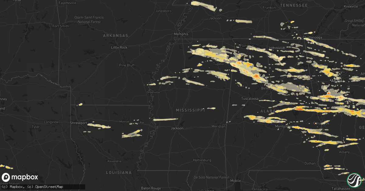
Hail Map in Tennessee on March 26, 2011
Get this storm
March 26 map
$229
one time, instant access
Download today. No call, no setup
Keep the $229
Bought the map and want the full workflow? Apply the entire $229 to a subscription within 7 days. None of it is wasted.
Every map, not just this one
This buys you this map. Subscription and you get every map we run, in the markets you choose from a few cities to whole states to nationwide. Plus real-time alerts the moment a storm fires.
Contact data
Name, contact info, occupancy, even credit band for addresses in the footprint. You go from where it hit to who to call.
Become the source they trust
Unlimited branding weather history reports on demand. You already have the documented answer ready for the property owner, and you are the one who showed up with it.
Property data and RoofTrace estimates
Pull up any address you have got, its value and the exact code rules for that jurisdiction, straight from One Click Code. Then RoofTrace estimates the squares, pitch, and roof value, priced the way you price.
Storm reports in Tennessee
Tennessee
| Date | Description |
|---|---|
| 03/26/20116:55 PM CDT | Qaurter size hail reported by dispatch. |
| 03/26/20116:30 PM CDT | Golf ball size hail reported by public. |
| 03/26/20115:55 PM CDT | A local report indicates 1.75 inch wind near MANCHESTER |
| 03/26/20115:55 PM CDT | Downed power lines and trees in the city of manchester. |
| 03/26/20114:30 PM CDT | A local report indicates 1.25 inch wind near NORMANDY |
| 03/26/20113:08 PM CDT | Quarter size hail reported 8 se linden. |
| 03/25/20119:24 PM CDT | Nickel to quarter sized hail on highway 43 near st. Joseph. |
| 03/25/20117:23 PM CDT | One tree down on roberts st reported by dispatch. |
| 03/25/20117:12 PM CDT | One tree down on highway 64 reported by dispatch. |
| 03/25/20117:10 PM CDT | One tree down on valley head rd reported by dispatch. |
All States Impacted by Hail Map on March 26, 2011
Cities Impacted by Hail Map on March 26, 2011
- Dahlonega, GA
- Okolona, MS
- Houston, MS
- Smithville, GA
- Scottsboro, AL
- Section, AL
- Dutton, AL
- Russellville, AL
- Riverside, AL
- Lincoln, AL
- Sylacauga, AL
- Goodwater, AL
- Haleyville, AL
- Piedmont, AL
- Oneonta, AL
- Cleveland, AL
- Gallant, AL
- Blountsville, AL
- Boaz, AL
- Attalla, AL
- Gadsden, AL
- Horton, AL
- Altoona, AL
- Centre, AL
- Alexander City, AL
- Holly Springs, MS
- Talbotton, GA
- Hamilton, GA
- Lafayette, AL
- West Point, GA
- Warm Springs, GA
- Shiloh, GA
- Manchester, GA
- Lanett, AL
- Valley, AL
- Pine Mountain Valley, GA
- Pine Mountain, GA
- Woodland, GA
- Thomaston, GA
- Rockford, AL
- Clanton, AL
- Verbena, AL
- Cairo, GA
- Ochlocknee, GA
- Hohenwald, TN
- Linden, TN
- Clifton, TN
- Bath Springs, TN
- Decaturville, TN
- Smithville, MS
- Amory, MS
- Talladega, AL
- Munford, AL
- White Plains, GA
- Crawfordville, GA
- Greensboro, GA
- Norwood, GA
- Buckhead, GA
- Sparta, GA
- Madison, GA
- Macon, GA
- Juliette, GA
- Courtland, AL
- Town Creek, AL
- Dadeville, AL
- Jacksons Gap, AL
- Salem, AL
- Opelika, AL
- Phenix City, AL
- Leesburg, GA
- Plantersville, AL
- Prattville, AL
- Jones, AL
- Billingsley, AL
- Newnan, GA
- Sharpsburg, GA
- Myrtle, MS
- Baldwyn, MS
- Guntown, MS
- Blue Mountain, MS
- Blue Springs, MS
- Saltillo, MS
- New Albany, MS
- Deatsville, AL
- Booth, AL
- Coosada, AL
- Millbrook, AL
- Reagan, TX
- Bremond, TX
- Rosebud, TX
- Selma, AL
- Kite, GA
- Wrightsville, GA
- Jackson, GA
- Jenkinsburg, GA
- Locust Grove, GA
- Rayville, LA
- Dallas, GA
- Acworth, GA
- Cartersville, GA
- Kennesaw, GA
- Flora, MS
- Ripley, MS
- Grenada, MS
- Oakland, MS
- Hardaway, AL
- Shorter, AL
- Lynchburg, TN
- Fayetteville, TN
- Preston, MS
- Hogansville, GA
- Moreland, GA
- Grantville, GA
- Senoia, GA
- Griffin, GA
- Williamson, GA
- Brooks, GA
- Pittsview, AL
- Omaha, GA
- Irwinton, GA
- Danville, GA
- Adrian, GA
- Toomsboro, GA
- Tennille, GA
- Harrison, GA
- Milledgeville, GA
- Gray, GA
- Haddock, GA
- Hillsboro, GA
- Colquitt, GA
- Donalsonville, GA
- Tishomingo, MS
- Detroit, AL
- Sulligent, AL
- Beaverton, AL
- Delta, AL
- Wedowee, AL
- Woodland, AL
- Heflin, AL
- Marion, AL
- Climax, GA
- Whigham, GA
- Pelham, GA
- Carrollton, GA
- Ashburn, GA
- Arabi, GA
- Dawson, GA
- Bronwood, GA
- Oakfield, GA
- Warwick, GA
- Cordele, GA
- Vincent, AL
- Alpine, AL
- Appling, GA
- Tremont, MS
- Vina, AL
- Hamilton, AL
- Jasper, AL
- Nauvoo, AL
- Blanco, TX
- Fulton, MS
- Cadwell, GA
- Alamo, GA
- Dublin, GA
- Swainsboro, GA
- Chauncey, GA
- Eastman, GA
- Soperton, GA
- Glenwood, GA
- Tarrytown, GA
- McRae Helena, GA
- Zebulon, GA
- Meansville, GA
- Rocky Ford, GA
- Statesboro, GA
- Garfield, GA
- Millen, GA
- Rising Fawn, GA
- Lookout Mountain, GA
- Wildwood, GA
- New Site, MS
- Booneville, MS
- Marietta, MS
- Rome, GA
- Lindale, GA
- Benoit, MS
- Morrison, TN
- Manchester, TN
- Arkansas City, AR
- Red Bay, AL
- Hodges, AL
- Golden, MS
- Banner, MS
- Bruce, MS
- Water Valley, MS
- Coffeeville, MS
- Hackleburg, AL
- Guin, AL
- Townley, AL
- Eldridge, AL
- Dora, AL
- Oakman, AL
- Lynn, AL
- Empire, AL
- Brilliant, AL
- Carbon Hill, AL
- Sumiton, AL
- Winfield, AL
- Cordova, AL
- Winnsboro, LA
- Gilbert, LA
- Fruithurst, AL
- Double Springs, AL
- Fayetteville, GA
- Harper, TX
- Fredericksburg, TX
- Quitman, GA
- Lizella, GA
- Powder Springs, GA
- Marietta, GA
- Trion, GA
- Hillsboro, TN
- Rienzi, MS
- Columbus, GA
- Rainbow City, AL
- Ashville, AL
- Franklin, TX
- Morris, AL
- Birmingham, AL
- Pinson, AL
- Mantachie, MS
- Midway, AL
- Fort Gaines, GA
- Morris, GA
- Shellman, GA
- Clayton, AL
- Parrott, GA
- Eufaula, AL
- Plains, GA
- Cuthbert, GA
- Abbeville, AL
- Georgetown, GA
- Vicksburg, MS
- Satartia, MS
- Bentonia, MS
- Valley Park, MS
- Redwood, MS
- Chatsworth, GA
- Kendalia, TX
- Merigold, MS
- Cleveland, MS
- Watkinsville, GA
- Good Hope, GA
- Bishop, GA
- Belvidere, TN
- Byhalia, MS
- Iron City, GA
- Brinson, GA
- Leighton, AL
- Armuchee, GA
- La Fayette, GA
- Summerville, GA
- Signal Mountain, TN
- Jemison, AL
- Randolph, AL
- Tillatoba, MS
- Oakwood, GA
- Cumming, GA
- Buford, GA
- Flowery Branch, GA
- Vardaman, MS
- Pittsboro, MS
- Houlka, MS
- Rockmart, GA
- Ranburne, AL
- Jackson, SC
- Aiken, SC
- Weogufka, AL
- Shelby, AL
- Thorsby, AL
- Flintstone, GA
- Chickamauga, GA
- Rossville, GA
- Hatchechubbee, AL
- Hurtsboro, AL
- Lenox, TN
- Dyersburg, TN
- Finley, TN
- Quitman, LA
- Corning, AR
- Piggott, AR
- Rector, AR
- Trussville, AL
- Milner, GA
- Palmetto, GA
- Whitesburg, GA
- Berry, AL
- Northport, AL
- Fort Payne, AL
- Columbia, LA
- Newellton, LA
- Grayson, LA
- Delhi, LA
- Chattanooga, TN
- Forsyth, GA
- Musella, GA
- Culloden, GA
- Resaca, GA
- Union Springs, AL
- Tanner, AL
- Madison, AL
- Decatur, AL
- Somerville, AL
- Union Grove, AL
- Grant, AL
- Guntersville, AL
- Arab, AL
- Taft, TN
- Hazel Green, AL
- Prospect, TN
- Ardmore, TN
- Toney, AL
- Aberdeen, MS
- Clarks Hill, SC
- Edgefield, SC
- Leeds, AL
- Pell City, AL
- Fultondale, AL
- Sterrett, AL
- Odenville, AL
- Gardendale, AL
- Vandiver, AL
- Cropwell, AL
- Moody, AL
- Potts Camp, MS
- South Pittsburg, TN
- Jamestown, LA
- Roswell, GA
- Seale, AL
- Fitzpatrick, AL
- Pike Road, AL
- Tuskegee, AL
- Richland, GA
- Preston, GA
- Cecil, AL
- Lumpkin, GA
- Boerne, TX
- Hickory Flat, MS
- Waterford, MS
- Groveoak, AL
- Franklin, GA
- Twin City, GA
- Midville, GA
- Fayette, AL
- Dumas, MS
- Phil Campbell, AL
- Logan, AL
- Cullman, AL
- Coushatta, LA
- Hall Summit, LA
- Ellijay, GA
- Bienville, LA
- New Market, AL
- Princeton, AL
- Monticello, FL
- Gordon, GA
- Sylvania, GA
- Yatesville, GA
- East Dublin, GA
- Montrose, GA
- Knoxville, GA
- Byron, GA
- Molena, GA
- Portal, GA
- Cusseta, AL
- Warner Robins, GA
- Waverly, AL
- Camp Hill, AL
- Jeffersonville, GA
- Daviston, AL
- McIntyre, GA
- Dry Branch, GA
- Metter, GA
- Atlanta, GA
- Oxford, AL
- Ringgold, GA
- Trenton, GA
- Guild, TN
- Big Creek, MS
- Pendergrass, GA
- Gainesville, GA
- Ashland, AL
- Kellyton, AL
- Lagrange, GA
- Estill, SC
- Barnesville, GA
- The Rock, GA
- Cobbtown, GA
- Garnett, SC
- Newington, GA
- Roberta, GA
- Lyons, GA
- Fort Valley, GA
- Equality, AL
- Woodbury, GA
- Parrish, AL
- Lineville, AL
- Wadley, AL
- Cragford, AL
- Monticello, GA
- Bradley, AR
- Plain Dealing, LA
- Normandy, TN
- Cherokee, AL
- Maben, MS
- Montgomery, AL
- Talmo, GA
- Braselton, GA
- Jefferson, GA
- Elm Grove, LA
- Dubberly, LA
- Heflin, LA
- Gibsland, LA
- Ringgold, LA
- Doyline, LA
- Kennedy, AL
- Vernon, AL
- Monroe, GA
- Covington, GA
- Bainbridge, GA
- Danville, AL
- Rainsville, AL
- Fyffe, AL
- Normangee, TX
- Elmore, AL
- Greenville, GA
- Gainesville, MO
- Pontiac, MO
- Isabella, MO
- Huntsville, AL
- Valdosta, GA
- Laceys Spring, AL
- Johnson City, TX
- Montevallo, AL
- Brierfield, AL
- Woodville, AL
- Hollytree, AL
- Trenton, AL
- Gurley, AL
- Owens Cross Roads, AL
- Paint Rock, AL
- New Hope, AL
- Forest Park, GA
- Riverdale, GA
- Rochelle, GA
- Abbeville, GA
- Stephens, GA
- Cobb, GA
- De Soto, GA
- Leslie, GA
- Langston, AL
- Ohatchee, AL
- Ragland, AL
- Winston, GA
- Mount Hope, AL
- Centerville, GA
- Jasper, TN
- Fort Oglethorpe, GA
- Fairburn, GA
- Clermont, GA
- Murrayville, GA
- Bear Creek, AL
- Trafford, AL
- Warrior, AL
- Hayden, AL
- Calera, AL
- Shreveport, LA
- Mansfield, LA
- Doddsville, MS
- Shaw, MS
- Boyle, MS
- Tallassee, AL
- Luthersville, GA
- Union City, GA
- Union Point, GA
- Flovilla, GA
- Eatonton, GA
- Sandersville, GA
- Pisgah, AL
- Henagar, AL
- Hollywood, AL
- Tupelo, MS
- Autaugaville, AL
- Sewanee, TN
- Drew, MS
- Pontotoc, MS
- Kingston, GA
- Banks, AL
- Louisville, AL
- Holly Pond, AL
- Mcdonough, GA
- Hampton, GA
- Maplesville, AL
- Stanton, AL
- Americus, GA
- Holcomb, MO
- Vinemont, AL
- Duck Hill, MS
- Eupora, MS
- Gore Springs, MS
- Fairmount, GA
- Calhoun, GA
- Ruleville, MS
- Valhermoso Springs, AL
- Pitts, GA
- Albertville, AL
- Wetumpka, AL
- Cascilla, MS
- Holcomb, MS
- Box Springs, GA
- Jacksonville, AL
- Lyerly, GA
- Gaylesville, AL
- Roanoke, AL
- Gay, GA
- Fackler, AL
- Flat Rock, AL
- Stevenson, AL
- Taylorsville, GA
- Decatur, GA
- Aragon, GA
- Silver Creek, GA
- Hiram, GA
- Smyrna, GA
- Emerson, GA
- Meigs, GA
- Hartselle, AL
- Washington, GA
- Rayle, GA
- Peachtree Corners, GA
- Alpharetta, GA
- Crane Hill, AL
- Arley, AL
- Bremen, AL
- Quinton, AL
- Houston, AL
- Mount Berry, GA
- Mableton, GA
- Hoschton, GA
- Auburn, GA
- Dacula, GA
- Suwanee, GA
- Lexington, TN
- Reagan, TN
- Hanceville, AL
- Bellefontaine, MS
- White, GA
- Adairsville, GA
- Cedar Bluff, AL
- Collinsville, AL
- Leesburg, AL
- Stone Mountain, GA
- Lithonia, GA
- Thomasville, GA
- Enid, MS
- Beulah, MS
- Greenwood Springs, MS
- Tunnel Hill, GA
- Rocky Face, GA
- Dalton, GA
- Trinity, AL
- Hillsboro, AL
- Marbury, AL
- Menlo, GA
- Falkner, MS
- Ashland, MS
- Commerce, GA
- Wartrace, TN
- Shelbyville, TN
- Tullahoma, TN
- Concord, GA
- Sugar Valley, GA
- Steele, AL
- Douglasville, GA
- Moulton, AL
- Ball Ground, GA
- Oxford, MS
- Paris, MS
- Lowndesboro, AL
- Cedarbluff, MS
- Woodland, MS
- West Point, MS
- Mantee, MS
- Woodstock, GA
- Loganville, GA
- Conyers, GA
- Madison, MS
- Mayersville, MS
- Fosters, AL
- Knoxville, AL
- Ralph, AL
- Comfort, TX
- Lamar, MS
- Cuba, AL
- Lauderdale, MS
- Hamilton, MS
- Nettleton, MS
- Shannon, MS
- Caledonia, MS
- Gattman, MS
- Muscadine, AL
- Wellington, AL
- Bogart, GA
- Oxford, GA
- Arnoldsville, GA
- Social Circle, GA
- Hixson, TN
- Soddy Daisy, TN
- Coldwater, MS
- Aliceville, AL
- Dennis, MS
- Mooreville, MS
- Abbeville, MS
- Belmont, MS
- Dawsonville, GA
- Alexandria, AL
- Addison, AL
- Round Mountain, TX
- Mathews, AL
- Grovetown, GA
- Buchanan, GA
- Uniontown, AL
- Newbern, AL
- Sawyerville, AL
- Greensboro, AL
- Rhine, GA
- Milan, GA
- Lavinia, TN
- Cedar Grove, TN
- Coleman, GA
- Newbern, TN
- Trenton, TN
- Humboldt, TN
- Theodosia, MO
- Evans, GA
- Alto, GA
- Lula, GA
- Winder, GA
- Lead Hill, AR
- Walthall, MS
- McGehee, AR
- Warrenton, GA
- Louisville, MS
- Noxapater, MS
- Philadelphia, MS
- Five Points, AL
- Senatobia, MS
- Loretto, TN
- Westpoint, TN
- Edison, GA
- Goodspring, TN
- Five Points, TN
- Leoma, TN
- Minor Hill, TN
- Spruce Pine, AL
- Augusta, GA
- Hephzibah, GA
- Jonesboro, GA
- Tyrone, GA
- Peachtree City, GA
- Florence, AL
- Killen, AL
- Ecru, MS
- Schlater, MS
- Minter City, MS
- Bremen, GA
- Lake Park, GA
- Springville, AL
- Marion Junction, AL
- Camilla, GA
- Athens, AL
- Lithia Springs, GA
- Pelham, TN
- Dearing, GA
- Harlem, GA
- Pulaski, TN
- Ardmore, AL
- Canton, GA
- Woodstock, AL
- Columbiana, AL
- West Blocton, AL
- Vance, AL
- Sherwood, TN
- Grayson, GA
- Cusseta, GA
- Rydal, GA
- Waleska, GA
- Cleveland, GA
- Sylvania, AL
- Modoc, SC
- Kirbyville, MO
- Scotts Hill, TN
- Estillfork, AL
- Sondheimer, LA
- Transylvania, LA
- Tutwiler, MS
- McCarley, MS
- Carrollton, MS
- Whitwell, TN
- Tuscumbia, AL
- Charleston, MS
- Pineland, SC
- Sheldon, SC
- Ridgeland, SC
- Estill Springs, TN
- Cedartown, GA
- Epps, LA
- Medina, TN
- Friendship, TN
- Mound Bayou, MS
- York, AL
- Tallapoosa, GA
- Ellenwood, GA
- Rex, GA
- Stockbridge, GA
- Cedarcreek, MO
- Steele, MO
- Cooter, MO
- Villa Rica, GA
- Thaxton, MS
- Calhoun City, MS
- Simsboro, LA
- Fort Mitchell, AL
- Milan, TN
- Waynesboro, TN
- Millport, AL
- Falkville, AL
- Muscle Shoals, AL
- Baileyton, AL
- Joppa, AL
- Eva, AL
- Yemassee, SC
- Seabrook, SC
- Coosawhatchie, SC
- Eutaw, AL
- Eastaboga, AL
- Harpersville, AL
- Etta, MS
- Iuka, MS
- Mount Olive, AL
- Adamsville, AL
- Brookside, AL
- Graysville, AL
- Como, MS
- Anniston, AL
- Docena, AL
- Childersburg, AL
- Graham, AL
- Valley Head, AL
- Mentone, AL
- Notasulga, AL
- Caruthersville, MO
- Rock Spring, GA
- Lookout Mountain, TN


