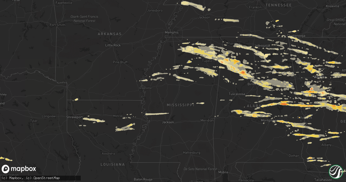
Hail Map in Alabama on March 26, 2011
Get this storm
March 26 map
$229
one time, instant access
Download today. No call, no setup
Keep the $229
Bought the map and want the full workflow? Apply the entire $229 to a subscription within 7 days. None of it is wasted.
Every map, not just this one
This buys you this map. Subscription and you get every map we run, in the markets you choose from a few cities to whole states to nationwide. Plus real-time alerts the moment a storm fires.
Contact data
Name, contact info, occupancy, even credit band for addresses in the footprint. You go from where it hit to who to call.
Become the source they trust
Unlimited branding weather history reports on demand. You already have the documented answer ready for the property owner, and you are the one who showed up with it.
Property data and RoofTrace estimates
Pull up any address you have got, its value and the exact code rules for that jurisdiction, straight from One Click Code. Then RoofTrace estimates the squares, pitch, and roof value, priced the way you price.
Storm reports in Alabama
Alabama
| Date | Description |
|---|---|
| 03/26/20116:55 PM CDT | Quarter size hail in gadsden and heavy rain in gadsden and rainbow city. |
| 03/26/20116:40 PM CDT | Quarter size hail. |
| 03/26/20116:30 PM CDT | Quarter size hail. |
| 03/26/20116:00 PM CDT | Large metal sign blown down. Estimated wind gust of 60 mph. |
| 03/26/20115:31 PM CDT | A local report indicates 2.00 inch wind near EUFAULA |
| 03/26/20114:58 PM CDT | A local report indicates 1.00 inch wind near HURTSBORO |
| 03/26/20114:55 PM CDT | Trees down. |
| 03/26/20114:25 PM CDT | A local report indicates 1.75 inch wind near HARDAWAY |
| 03/26/20114:15 PM CDT | Trees and power lines down in the community of pea ridge. |
| 03/26/20114:14 PM CDT | Golf ball size hail reported in the hugley community. |
| 03/26/20114:10 PM CDT | Damage in the aldrich community attributed to a brief tornado touchdown with winds of 90mph. |
| 03/26/20114:10 PM CDT | Quarter size hail |
| 03/26/20114:10 PM CDT | Nws employee reports quarter size hail. |
| 03/26/20114:07 PM CDT | Damage in the aldrich community attributed to a brief tornado touchdown with winds of 90mph. |
| 03/26/20114:06 PM CDT | Quarter size hail reported at shelby county academy on county road 16. |
| 03/26/20114:00 PM CDT | Golf ball size hail reported in the hugley community. |
| 03/26/20113:53 PM CDT | A local report indicates 1.00 inch wind near MILLBROOK |
| 03/26/20113:40 PM CDT | Quarter sized hail reported at a grocery store in lafayette. |
| 03/26/20113:38 PM CDT | Quarter size hail in pine level. |
| 03/26/20113:30 PM CDT | A local report indicates 1.00 inch wind near 5 E MARKTON |
| 03/26/20113:10 PM CDT | A local report indicates 1.75 inch wind near BURNSVILLE |
| 03/26/20113:07 PM CDT | A local report indicates 2.00 inch wind near JACKSONS GAP |
| 03/26/20113:05 PM CDT | Mobile home destroyed. |
| 03/26/20113:05 PM CDT | Tree down on power lines at cr 85 and 102 in pine level. A few other trees were blown down in the area. |
| 03/26/20113:05 PM CDT | Prattville high school baseball field complex sustained damage. Fencing was blown down and outbuildings were damaged. Small hail was covering the ground several inches |
| 03/26/20113:05 PM CDT | Prattville high school baseball field complex sustained damage. Fencing was blown down and outbuildings were damaged. Small hail was covering the ground several inches |
| 03/26/20113:05 PM CDT | Trees down along county rd 19 in the vida area. |
| 03/26/20113:05 PM CDT | One mobile home damaged and one destroyed. Several outbuildings damaged. Several homes with shingle damage. Trees snapped off and uprooted. Damage near county road 19n |
| 03/26/20113:05 PM CDT | Three and one half inch hail. |
| 03/26/20113:03 PM CDT | A local report indicates 1.00 inch wind near VALLEY GRANDE |
| 03/26/20112:55 PM CDT | Half dollar size hail in eagle creek. |
| 03/26/20112:50 PM CDT | At least quarter size hail fell in the hackneyville area and covered the ground in spots. |
| 03/26/20112:45 PM CDT | Sheriffs office reports golf ball size hail covering the ground in many locations within a three mile radius of rockford...and in the community of richville. |
| 03/26/20112:42 PM CDT | A local report indicates 1.00 inch wind near 1 N ALEXANDER CITY |
| 03/26/20112:35 PM CDT | Sheriffs office reports golf ball size hail covering the ground in many locations within a three mile radius of rockford...and in the community of richville. |
| 03/26/20112:07 PM CDT | Trees down. |
| 03/26/20112:01 PM CDT | Quarter size hail reported at exit 212 on i-65. |
| 03/26/20112:00 PM CDT | One and one quarter inch hail at the chilton county airport. |
| 03/26/20111:59 PM CDT | Ping pong ball size hail reported at the clanton country club. |
| 03/26/20111:55 PM CDT | Public report of half dollar size hail in clanton. |
| 03/26/20111:34 PM CDT | 1 1/2 inch hail. |
| 03/26/20111:28 PM CDT | I inch hail reported by trained spotter. |
| 03/25/201111:06 PM CDT | Public report of quarter sized hail on county road 5...near micaville. |
| 03/25/201110:55 PM CDT | A local report indicates 1.00 inch wind near VINCENT |
| 03/25/201110:44 PM CDT | Quarter size hail falling in vernon. |
| 03/25/201110:30 PM CDT | Trees and power lines down. |
| 03/25/201110:23 PM CDT | Hail up to 2 inches in diameter reported. |
| 03/25/201110:15 PM CDT | Quarter size hail reported. |
| 03/25/20119:45 PM CDT | A local report indicates 1.00 inch wind near CRANE HILL |
| 03/25/20119:25 PM CDT | Pea to quarter size hail. |
| 03/25/20119:24 PM CDT | Golf ball size hail in shottsville. |
| 03/25/20119:13 PM CDT | Quarter size hail at colonnial pinnacle mall. |
| 03/25/20119:00 PM CDT | Quarter sized hail reported. |
| 03/25/20119:00 PM CDT | Golf ball size hail was reported near gadsden. |
| 03/25/20118:59 PM CDT | Quarter size hail in addison. |
| 03/25/20118:54 PM CDT | Hail at least golf ball size. Widespread damage to buildings and automobiles due to hail. |
| 03/25/20118:45 PM CDT | Golf ball size hail. |
| 03/25/20118:40 PM CDT | Golf ball size hail along state route 172 near the marion/franklin county line. |
| 03/25/20118:34 PM CDT | Trees down and out buildings damaged along empire road at drummond switch. |
| 03/25/20118:25 PM CDT | A local report indicates 1.75 inch wind near UNION GROVE |
| 03/25/20118:15 PM CDT | A local report indicates 1.00 inch wind near MOULTON |
| 03/25/20118:13 PM CDT | Ping pong ball size in jasper. |
| 03/25/20118:00 PM CDT | A local report indicates 1.00 inch wind near 2 W MORGAN CITY |
| 03/25/20118:00 PM CDT | A local report indicates 1.00 inch wind near UNION GROVE |
| 03/25/20117:52 PM CDT | Golf ball size hail in saragossa. |
| 03/25/20117:45 PM CDT | One inch hail covering the ground in eldridge. |
| 03/25/20117:33 PM CDT | Dime to quarter size hail on rutledge street in kansas. |
| 03/25/20117:17 PM CDT | Quarter to half dollar size hail in ellisville along highway 9. |
| 03/25/20117:03 PM CDT | A local report indicates 1.00 inch wind near TOWN CREEK |
| 03/25/20117:00 PM CDT | Nickel to quarter size hail along i-22 northeast of guin. |
All States Impacted by Hail Map on March 26, 2011
Cities Impacted by Hail Map on March 26, 2011
- Dahlonega, GA
- Okolona, MS
- Houston, MS
- Smithville, GA
- Scottsboro, AL
- Section, AL
- Dutton, AL
- Russellville, AL
- Riverside, AL
- Lincoln, AL
- Sylacauga, AL
- Goodwater, AL
- Haleyville, AL
- Piedmont, AL
- Oneonta, AL
- Cleveland, AL
- Gallant, AL
- Blountsville, AL
- Boaz, AL
- Attalla, AL
- Gadsden, AL
- Horton, AL
- Altoona, AL
- Centre, AL
- Alexander City, AL
- Holly Springs, MS
- Talbotton, GA
- Hamilton, GA
- Lafayette, AL
- West Point, GA
- Warm Springs, GA
- Shiloh, GA
- Manchester, GA
- Lanett, AL
- Valley, AL
- Pine Mountain Valley, GA
- Pine Mountain, GA
- Woodland, GA
- Thomaston, GA
- Rockford, AL
- Clanton, AL
- Verbena, AL
- Cairo, GA
- Ochlocknee, GA
- Hohenwald, TN
- Linden, TN
- Clifton, TN
- Bath Springs, TN
- Decaturville, TN
- Smithville, MS
- Amory, MS
- Talladega, AL
- Munford, AL
- White Plains, GA
- Crawfordville, GA
- Greensboro, GA
- Norwood, GA
- Buckhead, GA
- Sparta, GA
- Madison, GA
- Macon, GA
- Juliette, GA
- Courtland, AL
- Town Creek, AL
- Dadeville, AL
- Jacksons Gap, AL
- Salem, AL
- Opelika, AL
- Phenix City, AL
- Leesburg, GA
- Plantersville, AL
- Prattville, AL
- Jones, AL
- Billingsley, AL
- Newnan, GA
- Sharpsburg, GA
- Myrtle, MS
- Baldwyn, MS
- Guntown, MS
- Blue Mountain, MS
- Blue Springs, MS
- Saltillo, MS
- New Albany, MS
- Deatsville, AL
- Booth, AL
- Coosada, AL
- Millbrook, AL
- Reagan, TX
- Bremond, TX
- Rosebud, TX
- Selma, AL
- Kite, GA
- Wrightsville, GA
- Jackson, GA
- Jenkinsburg, GA
- Locust Grove, GA
- Rayville, LA
- Dallas, GA
- Acworth, GA
- Cartersville, GA
- Kennesaw, GA
- Flora, MS
- Ripley, MS
- Grenada, MS
- Oakland, MS
- Hardaway, AL
- Shorter, AL
- Lynchburg, TN
- Fayetteville, TN
- Preston, MS
- Hogansville, GA
- Moreland, GA
- Grantville, GA
- Senoia, GA
- Griffin, GA
- Williamson, GA
- Brooks, GA
- Pittsview, AL
- Omaha, GA
- Irwinton, GA
- Danville, GA
- Adrian, GA
- Toomsboro, GA
- Tennille, GA
- Harrison, GA
- Milledgeville, GA
- Gray, GA
- Haddock, GA
- Hillsboro, GA
- Colquitt, GA
- Donalsonville, GA
- Tishomingo, MS
- Detroit, AL
- Sulligent, AL
- Beaverton, AL
- Delta, AL
- Wedowee, AL
- Woodland, AL
- Heflin, AL
- Marion, AL
- Climax, GA
- Whigham, GA
- Pelham, GA
- Carrollton, GA
- Ashburn, GA
- Arabi, GA
- Dawson, GA
- Bronwood, GA
- Oakfield, GA
- Warwick, GA
- Cordele, GA
- Vincent, AL
- Alpine, AL
- Appling, GA
- Tremont, MS
- Vina, AL
- Hamilton, AL
- Jasper, AL
- Nauvoo, AL
- Blanco, TX
- Fulton, MS
- Cadwell, GA
- Alamo, GA
- Dublin, GA
- Swainsboro, GA
- Chauncey, GA
- Eastman, GA
- Soperton, GA
- Glenwood, GA
- Tarrytown, GA
- McRae Helena, GA
- Zebulon, GA
- Meansville, GA
- Rocky Ford, GA
- Statesboro, GA
- Garfield, GA
- Millen, GA
- Rising Fawn, GA
- Lookout Mountain, GA
- Wildwood, GA
- New Site, MS
- Booneville, MS
- Marietta, MS
- Rome, GA
- Lindale, GA
- Benoit, MS
- Morrison, TN
- Manchester, TN
- Arkansas City, AR
- Red Bay, AL
- Hodges, AL
- Golden, MS
- Banner, MS
- Bruce, MS
- Water Valley, MS
- Coffeeville, MS
- Hackleburg, AL
- Guin, AL
- Townley, AL
- Eldridge, AL
- Dora, AL
- Oakman, AL
- Lynn, AL
- Empire, AL
- Brilliant, AL
- Carbon Hill, AL
- Sumiton, AL
- Winfield, AL
- Cordova, AL
- Winnsboro, LA
- Gilbert, LA
- Fruithurst, AL
- Double Springs, AL
- Fayetteville, GA
- Harper, TX
- Fredericksburg, TX
- Quitman, GA
- Lizella, GA
- Powder Springs, GA
- Marietta, GA
- Trion, GA
- Hillsboro, TN
- Rienzi, MS
- Columbus, GA
- Rainbow City, AL
- Ashville, AL
- Franklin, TX
- Morris, AL
- Birmingham, AL
- Pinson, AL
- Mantachie, MS
- Midway, AL
- Fort Gaines, GA
- Morris, GA
- Shellman, GA
- Clayton, AL
- Parrott, GA
- Eufaula, AL
- Plains, GA
- Cuthbert, GA
- Abbeville, AL
- Georgetown, GA
- Vicksburg, MS
- Satartia, MS
- Bentonia, MS
- Valley Park, MS
- Redwood, MS
- Chatsworth, GA
- Kendalia, TX
- Merigold, MS
- Cleveland, MS
- Watkinsville, GA
- Good Hope, GA
- Bishop, GA
- Belvidere, TN
- Byhalia, MS
- Iron City, GA
- Brinson, GA
- Leighton, AL
- Armuchee, GA
- La Fayette, GA
- Summerville, GA
- Signal Mountain, TN
- Jemison, AL
- Randolph, AL
- Tillatoba, MS
- Oakwood, GA
- Cumming, GA
- Buford, GA
- Flowery Branch, GA
- Vardaman, MS
- Pittsboro, MS
- Houlka, MS
- Rockmart, GA
- Ranburne, AL
- Jackson, SC
- Aiken, SC
- Weogufka, AL
- Shelby, AL
- Thorsby, AL
- Flintstone, GA
- Chickamauga, GA
- Rossville, GA
- Hatchechubbee, AL
- Hurtsboro, AL
- Lenox, TN
- Dyersburg, TN
- Finley, TN
- Quitman, LA
- Corning, AR
- Piggott, AR
- Rector, AR
- Trussville, AL
- Milner, GA
- Palmetto, GA
- Whitesburg, GA
- Berry, AL
- Northport, AL
- Fort Payne, AL
- Columbia, LA
- Newellton, LA
- Grayson, LA
- Delhi, LA
- Chattanooga, TN
- Forsyth, GA
- Musella, GA
- Culloden, GA
- Resaca, GA
- Union Springs, AL
- Tanner, AL
- Madison, AL
- Decatur, AL
- Somerville, AL
- Union Grove, AL
- Grant, AL
- Guntersville, AL
- Arab, AL
- Taft, TN
- Hazel Green, AL
- Prospect, TN
- Ardmore, TN
- Toney, AL
- Aberdeen, MS
- Clarks Hill, SC
- Edgefield, SC
- Leeds, AL
- Pell City, AL
- Fultondale, AL
- Sterrett, AL
- Odenville, AL
- Gardendale, AL
- Vandiver, AL
- Cropwell, AL
- Moody, AL
- Potts Camp, MS
- South Pittsburg, TN
- Jamestown, LA
- Roswell, GA
- Seale, AL
- Fitzpatrick, AL
- Pike Road, AL
- Tuskegee, AL
- Richland, GA
- Preston, GA
- Cecil, AL
- Lumpkin, GA
- Boerne, TX
- Hickory Flat, MS
- Waterford, MS
- Groveoak, AL
- Franklin, GA
- Twin City, GA
- Midville, GA
- Fayette, AL
- Dumas, MS
- Phil Campbell, AL
- Logan, AL
- Cullman, AL
- Coushatta, LA
- Hall Summit, LA
- Ellijay, GA
- Bienville, LA
- New Market, AL
- Princeton, AL
- Monticello, FL
- Gordon, GA
- Sylvania, GA
- Yatesville, GA
- East Dublin, GA
- Montrose, GA
- Knoxville, GA
- Byron, GA
- Molena, GA
- Portal, GA
- Cusseta, AL
- Warner Robins, GA
- Waverly, AL
- Camp Hill, AL
- Jeffersonville, GA
- Daviston, AL
- McIntyre, GA
- Dry Branch, GA
- Metter, GA
- Atlanta, GA
- Oxford, AL
- Ringgold, GA
- Trenton, GA
- Guild, TN
- Big Creek, MS
- Pendergrass, GA
- Gainesville, GA
- Ashland, AL
- Kellyton, AL
- Lagrange, GA
- Estill, SC
- Barnesville, GA
- The Rock, GA
- Cobbtown, GA
- Garnett, SC
- Newington, GA
- Roberta, GA
- Lyons, GA
- Fort Valley, GA
- Equality, AL
- Woodbury, GA
- Parrish, AL
- Lineville, AL
- Wadley, AL
- Cragford, AL
- Monticello, GA
- Bradley, AR
- Plain Dealing, LA
- Normandy, TN
- Cherokee, AL
- Maben, MS
- Montgomery, AL
- Talmo, GA
- Braselton, GA
- Jefferson, GA
- Elm Grove, LA
- Dubberly, LA
- Heflin, LA
- Gibsland, LA
- Ringgold, LA
- Doyline, LA
- Kennedy, AL
- Vernon, AL
- Monroe, GA
- Covington, GA
- Bainbridge, GA
- Danville, AL
- Rainsville, AL
- Fyffe, AL
- Normangee, TX
- Elmore, AL
- Greenville, GA
- Gainesville, MO
- Pontiac, MO
- Isabella, MO
- Huntsville, AL
- Valdosta, GA
- Laceys Spring, AL
- Johnson City, TX
- Montevallo, AL
- Brierfield, AL
- Woodville, AL
- Hollytree, AL
- Trenton, AL
- Gurley, AL
- Owens Cross Roads, AL
- Paint Rock, AL
- New Hope, AL
- Forest Park, GA
- Riverdale, GA
- Rochelle, GA
- Abbeville, GA
- Stephens, GA
- Cobb, GA
- De Soto, GA
- Leslie, GA
- Langston, AL
- Ohatchee, AL
- Ragland, AL
- Winston, GA
- Mount Hope, AL
- Centerville, GA
- Jasper, TN
- Fort Oglethorpe, GA
- Fairburn, GA
- Clermont, GA
- Murrayville, GA
- Bear Creek, AL
- Trafford, AL
- Warrior, AL
- Hayden, AL
- Calera, AL
- Shreveport, LA
- Mansfield, LA
- Doddsville, MS
- Shaw, MS
- Boyle, MS
- Tallassee, AL
- Luthersville, GA
- Union City, GA
- Union Point, GA
- Flovilla, GA
- Eatonton, GA
- Sandersville, GA
- Pisgah, AL
- Henagar, AL
- Hollywood, AL
- Tupelo, MS
- Autaugaville, AL
- Sewanee, TN
- Drew, MS
- Pontotoc, MS
- Kingston, GA
- Banks, AL
- Louisville, AL
- Holly Pond, AL
- Mcdonough, GA
- Hampton, GA
- Maplesville, AL
- Stanton, AL
- Americus, GA
- Holcomb, MO
- Vinemont, AL
- Duck Hill, MS
- Eupora, MS
- Gore Springs, MS
- Fairmount, GA
- Calhoun, GA
- Ruleville, MS
- Valhermoso Springs, AL
- Pitts, GA
- Albertville, AL
- Wetumpka, AL
- Cascilla, MS
- Holcomb, MS
- Box Springs, GA
- Jacksonville, AL
- Lyerly, GA
- Gaylesville, AL
- Roanoke, AL
- Gay, GA
- Fackler, AL
- Flat Rock, AL
- Stevenson, AL
- Taylorsville, GA
- Decatur, GA
- Aragon, GA
- Silver Creek, GA
- Hiram, GA
- Smyrna, GA
- Emerson, GA
- Meigs, GA
- Hartselle, AL
- Washington, GA
- Rayle, GA
- Peachtree Corners, GA
- Alpharetta, GA
- Crane Hill, AL
- Arley, AL
- Bremen, AL
- Quinton, AL
- Houston, AL
- Mount Berry, GA
- Mableton, GA
- Hoschton, GA
- Auburn, GA
- Dacula, GA
- Suwanee, GA
- Lexington, TN
- Reagan, TN
- Hanceville, AL
- Bellefontaine, MS
- White, GA
- Adairsville, GA
- Cedar Bluff, AL
- Collinsville, AL
- Leesburg, AL
- Stone Mountain, GA
- Lithonia, GA
- Thomasville, GA
- Enid, MS
- Beulah, MS
- Greenwood Springs, MS
- Tunnel Hill, GA
- Rocky Face, GA
- Dalton, GA
- Trinity, AL
- Hillsboro, AL
- Marbury, AL
- Menlo, GA
- Falkner, MS
- Ashland, MS
- Commerce, GA
- Wartrace, TN
- Shelbyville, TN
- Tullahoma, TN
- Concord, GA
- Sugar Valley, GA
- Steele, AL
- Douglasville, GA
- Moulton, AL
- Ball Ground, GA
- Oxford, MS
- Paris, MS
- Lowndesboro, AL
- Cedarbluff, MS
- Woodland, MS
- West Point, MS
- Mantee, MS
- Woodstock, GA
- Loganville, GA
- Conyers, GA
- Madison, MS
- Mayersville, MS
- Fosters, AL
- Knoxville, AL
- Ralph, AL
- Comfort, TX
- Lamar, MS
- Cuba, AL
- Lauderdale, MS
- Hamilton, MS
- Nettleton, MS
- Shannon, MS
- Caledonia, MS
- Gattman, MS
- Muscadine, AL
- Wellington, AL
- Bogart, GA
- Oxford, GA
- Arnoldsville, GA
- Social Circle, GA
- Hixson, TN
- Soddy Daisy, TN
- Coldwater, MS
- Aliceville, AL
- Dennis, MS
- Mooreville, MS
- Abbeville, MS
- Belmont, MS
- Dawsonville, GA
- Alexandria, AL
- Addison, AL
- Round Mountain, TX
- Mathews, AL
- Grovetown, GA
- Buchanan, GA
- Uniontown, AL
- Newbern, AL
- Sawyerville, AL
- Greensboro, AL
- Rhine, GA
- Milan, GA
- Lavinia, TN
- Cedar Grove, TN
- Coleman, GA
- Newbern, TN
- Trenton, TN
- Humboldt, TN
- Theodosia, MO
- Evans, GA
- Alto, GA
- Lula, GA
- Winder, GA
- Lead Hill, AR
- Walthall, MS
- McGehee, AR
- Warrenton, GA
- Louisville, MS
- Noxapater, MS
- Philadelphia, MS
- Five Points, AL
- Senatobia, MS
- Loretto, TN
- Westpoint, TN
- Edison, GA
- Goodspring, TN
- Five Points, TN
- Leoma, TN
- Minor Hill, TN
- Spruce Pine, AL
- Augusta, GA
- Hephzibah, GA
- Jonesboro, GA
- Tyrone, GA
- Peachtree City, GA
- Florence, AL
- Killen, AL
- Ecru, MS
- Schlater, MS
- Minter City, MS
- Bremen, GA
- Lake Park, GA
- Springville, AL
- Marion Junction, AL
- Camilla, GA
- Athens, AL
- Lithia Springs, GA
- Pelham, TN
- Dearing, GA
- Harlem, GA
- Pulaski, TN
- Ardmore, AL
- Canton, GA
- Woodstock, AL
- Columbiana, AL
- West Blocton, AL
- Vance, AL
- Sherwood, TN
- Grayson, GA
- Cusseta, GA
- Rydal, GA
- Waleska, GA
- Cleveland, GA
- Sylvania, AL
- Modoc, SC
- Kirbyville, MO
- Scotts Hill, TN
- Estillfork, AL
- Sondheimer, LA
- Transylvania, LA
- Tutwiler, MS
- McCarley, MS
- Carrollton, MS
- Whitwell, TN
- Tuscumbia, AL
- Charleston, MS
- Pineland, SC
- Sheldon, SC
- Ridgeland, SC
- Estill Springs, TN
- Cedartown, GA
- Epps, LA
- Medina, TN
- Friendship, TN
- Mound Bayou, MS
- York, AL
- Tallapoosa, GA
- Ellenwood, GA
- Rex, GA
- Stockbridge, GA
- Cedarcreek, MO
- Steele, MO
- Cooter, MO
- Villa Rica, GA
- Thaxton, MS
- Calhoun City, MS
- Simsboro, LA
- Fort Mitchell, AL
- Milan, TN
- Waynesboro, TN
- Millport, AL
- Falkville, AL
- Muscle Shoals, AL
- Baileyton, AL
- Joppa, AL
- Eva, AL
- Yemassee, SC
- Seabrook, SC
- Coosawhatchie, SC
- Eutaw, AL
- Eastaboga, AL
- Harpersville, AL
- Etta, MS
- Iuka, MS
- Mount Olive, AL
- Adamsville, AL
- Brookside, AL
- Graysville, AL
- Como, MS
- Anniston, AL
- Docena, AL
- Childersburg, AL
- Graham, AL
- Valley Head, AL
- Mentone, AL
- Notasulga, AL
- Caruthersville, MO
- Rock Spring, GA
- Lookout Mountain, TN


