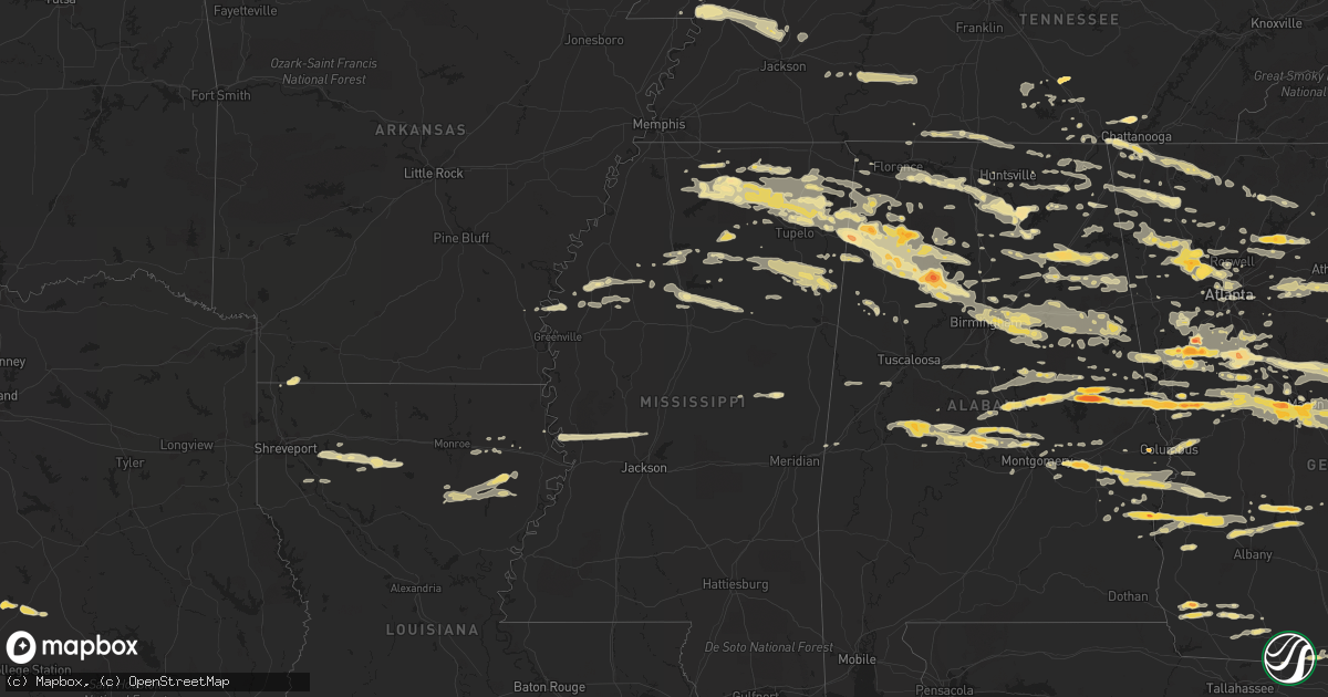
Hail Map in Georgia on March 26, 2011
Get this storm
March 26 map
$229
one time, instant access
Download today. No call, no setup
Keep the $229
Bought the map and want the full workflow? Apply the entire $229 to a subscription within 7 days. None of it is wasted.
Every map, not just this one
This buys you this map. Subscription and you get every map we run, in the markets you choose from a few cities to whole states to nationwide. Plus real-time alerts the moment a storm fires.
Contact data
Name, contact info, occupancy, even credit band for addresses in the footprint. You go from where it hit to who to call.
Become the source they trust
Unlimited branding weather history reports on demand. You already have the documented answer ready for the property owner, and you are the one who showed up with it.
Property data and RoofTrace estimates
Pull up any address you have got, its value and the exact code rules for that jurisdiction, straight from One Click Code. Then RoofTrace estimates the squares, pitch, and roof value, priced the way you price.
Storm reports in Georgia
Georgia
| Date | Description |
|---|---|
| 03/26/20116:57 PM CDT | Rotating wall cloud also observed to the west |
| 03/26/20116:56 PM CDT | A local report indicates 1.25 inch wind near 4 ESE SANDY POINT |
| 03/26/20116:43 PM CDT | Johnson county ema director relayed a report of hail the size of quarters covering the ground. |
| 03/26/20116:42 PM CDT | Storm survey confirmed ef1 tornado with a path length of 3.1 miles. Maximum path width was 0.25 mile. One mobile home completely destroyed and thrown 30 yards. Several |
| 03/26/20116:42 PM CDT | A local report indicates 1.25 inch wind near 5 NNE PORTAL |
| 03/26/20116:41 PM CDT | Possible tornado. 1 mobile home destroyed on lonnie burke rd. 2 mobile homes damaged on motes rd. |
| 03/26/20116:40 PM CDT | Storm survey confirmed ef0 tornado with path length of 0.6 miles. Maximum path width was 100 yards. Two mobile homes had siding and under-siding damaged along with some |
| 03/26/20116:40 PM CDT | A local report indicates 1.75 inch wind near 6 N PORTAL |
| 03/26/20116:36 PM CDT | Several trees down on joe stephens road. Some as big as 30 inches in diameter. |
| 03/26/20116:36 PM CDT | Trees down and damage to mobile homes north of portal around moore road and old portal road. Large hail of unknown size fell. Injuries unknown at this time. Emergency c |
| 03/26/20116:33 PM CDT | A local report indicates 1.75 inch wind near KITE |
| 03/26/20116:22 PM CDT | Emergency management/randolph sheriff dept. Report a tornado touchdown in the city of benevolence. Damage includes several trees and powerlines down...one mobile home d |
| 03/26/20115:35 PM CDT | Eufaula police department reported a tornado on the ground in georgetown. |
| 03/26/20115:00 PM CDT | A local report indicates 1.00 inch wind near 1 WNW GEORGIA VETERANS |
| 03/26/20114:55 PM CDT | A local report indicates 1.00 inch wind near 1 ENE UPATOI |
| 03/26/20114:54 PM CDT | Brief tornado touchdown confirmed on the north and east side of leesburg. People reported seeing debris circulating in the air. Minor damage to light poles...trees and |
| 03/26/20114:48 PM CDT | Amatuer radio operator reported quarter size hail |
| 03/26/20114:48 PM CDT | A local report indicates 1.75 inch wind near W CORDELE |
| 03/26/20114:45 PM CDT | A local report indicates 1.00 inch wind near 6 NNE WARNER ROBINS |
| 03/26/20114:40 PM CDT | Nws personnel in conjuction with local emer mgmt determined that a brief ef-0 tornado touched down near the sumter-crisp county line over lake blackshear. Maximum wind |
| 03/26/20114:26 PM CDT | A local report indicates 1.00 inch wind near 1 WSW SENOIA |
| 03/26/20114:21 PM CDT | A local report indicates 2.50 inch wind near ESE LIZELLA |
| 03/26/20114:10 PM CDT | A local report indicates 1.75 inch wind near 1 ENE LAKE TOBESOFKEE |
| 03/26/20114:04 PM CDT | Public reported quarter to golf ball sized hail in macon. |
| 03/26/20113:40 PM CDT | On highway 16 |
| 03/26/20113:35 PM CDT | A local report indicates 1.00 inch wind near GRIFFIN |
| 03/26/20113:27 PM CDT | Quarter size hail reported by sheriffs deputy. Lasted approx. 10 min. |
| 03/26/20113:10 PM CDT | Hail blanketing the ground. |
| 03/26/20113:00 PM CDT | Busting windshields. |
| 03/26/20113:00 PM CDT | Several powerlines down. |
| 03/26/20113:00 PM CDT | On georgia 36. |
| 03/26/20112:55 PM CDT | A local report indicates 4.25 inch wind near 9 W SENOIA |
| 03/26/20112:55 PM CDT | A local report indicates 2.75 inch wind near MORELAND |
| 03/26/20112:50 PM CDT | A local report indicates 1.75 inch wind near GRANTVILLE |
| 03/26/20112:50 PM CDT | Hail larger than golf balls...windshields shattered...car accident on hwy 29 near the interstate in moreland. |
| 03/26/20112:50 PM CDT | A local report indicates 1.25 inch wind near SOPERTON |
| 03/26/20112:30 PM CDT | A local report indicates 1.00 inch wind near MANCHESTER |
| 03/26/20112:10 PM CDT | At highway 354 and kings gap road. |
| 03/26/20112:10 PM CDT | A local report indicates 1.75 inch wind near 1 N PINE MOUNTAIN VALLE |
| 03/26/20112:02 PM CDT | On hopewell church road. |
| 03/26/20112:00 PM CDT | 1 mile east of exit 30 on i-185. |
| 03/26/20111:32 PM CDT | Quarter to golf ball size hail reported |
| 03/26/201112:55 PM CDT | Hail reported by sheriff deputy. |
| 03/26/201111:45 AM CDT | A local report indicates 1.75 inch wind near 1 S COLQUITT |
| 03/26/20115:26 AM CDT | A local report indicates 1.00 inch wind near SILOAM |
| 03/26/20115:15 AM CDT | A local report indicates 1.00 inch wind near 2 S MAYSVILLE |
| 03/26/20112:56 AM CDT | Amateur radio relayed a report of quarter sized hail at the intersection of state road 36 and state road 74. |
| 03/26/20112:55 AM CDT | A local report indicates 1.00 inch wind near THOMASTON |
| 03/25/201110:32 PM CDT | Public reports quarter sized hail in lawrenceville. |
| 03/25/201110:25 PM CDT | Public reports quarter sized hail in lawrenceville. |
| 03/25/20119:53 PM CDT | Public reported quarter-sized hail 5 miles ene of alpharetta. |
| 03/25/20119:51 PM CDT | A local report indicates 1.00 inch wind near MARIETTA |
| 03/25/20119:47 PM CDT | Public reported dime to golf ball sized hail in flowery branch. |
| 03/25/20119:45 PM CDT | Public reports quarter-sized hail in flowery branch. |
| 03/25/20119:40 PM CDT | A local report indicates 1.75 inch wind near DUE WEST |
| 03/25/20119:40 PM CDT | Public reports quarter-sized hail in cumming. |
| 03/25/20119:38 PM CDT | A local report indicates 1.75 inch wind near 5 W KENNESAW |
| 03/25/20119:37 PM CDT | Public reported quarter-sized hail in oakwood. |
| 03/25/20119:37 PM CDT | A local report indicates 1.75 inch wind near FLOWERY BRANCH |
| 03/25/20119:34 PM CDT | Public reported quarter-sized hail in oakwood. |
| 03/25/20119:30 PM CDT | Public reports dime to quarter sized hail in acworth. |
| 03/25/20119:20 PM CDT | Public reported nickle and quarter sized hail in cartersville. |
| 03/25/20119:15 PM CDT | Public reported quarter-sized hail in bartow county. |
| 03/25/20118:57 PM CDT | Cherokee county emergency management relayed reports of quarter sized hail 4.9 miles ne of waleska. |
| 03/25/20118:55 PM CDT | Public reported quarter-sized hail in rome. |
| 03/25/20118:49 PM CDT | A local report indicates 1.00 inch wind near ROME |
| 03/25/20118:45 PM CDT | Nws survey reported ef1 tornado with wind speeds of 90 to 100 mph. 200 to 300 pine trees snapped and some oak trees uprooted. Trees fell on homes. |
| 03/25/20118:27 PM CDT | Public reports quarter sized hail in calhoun. |
| 03/25/20118:25 PM CDT | A porch of a home was destroyed. Several trees in the area were also downed. |
| 03/25/20118:20 PM CDT | A local report indicates 1.00 inch wind near CALHOUN |
| 03/25/20118:19 PM CDT | A local report indicates 1.00 inch wind near CALHOUN |
| 03/25/20118:15 PM CDT | Quarter to half dollar size hail. |
| 03/25/20117:58 PM CDT | A local report indicates 1.00 inch wind near ETON |
| 03/25/20117:15 PM CDT | A local report indicates 1.00 inch wind near LAKEVIEW |
| 03/25/20117:13 PM CDT | Tornado reported at the middle georgia regional airport. |
| 03/25/20117:10 PM CDT | A nws assessment team determined with the help of the county em that straight line winds of 75 mph removed 40 percent of the roof of the days inn motel in byron. A bill |
| 03/25/20117:10 PM CDT | A local report indicates 1.00 inch wind near ROSSVILLE |
| 03/25/20117:00 PM CDT | Stewart county sheriff reported a possible tornado with trees down on canyon road. |
All States Impacted by Hail Map on March 26, 2011
Cities Impacted by Hail Map on March 26, 2011
- Dahlonega, GA
- Okolona, MS
- Houston, MS
- Smithville, GA
- Scottsboro, AL
- Section, AL
- Dutton, AL
- Russellville, AL
- Riverside, AL
- Lincoln, AL
- Sylacauga, AL
- Goodwater, AL
- Haleyville, AL
- Piedmont, AL
- Oneonta, AL
- Cleveland, AL
- Gallant, AL
- Blountsville, AL
- Boaz, AL
- Attalla, AL
- Gadsden, AL
- Horton, AL
- Altoona, AL
- Centre, AL
- Alexander City, AL
- Holly Springs, MS
- Talbotton, GA
- Hamilton, GA
- Lafayette, AL
- West Point, GA
- Warm Springs, GA
- Shiloh, GA
- Manchester, GA
- Lanett, AL
- Valley, AL
- Pine Mountain Valley, GA
- Pine Mountain, GA
- Woodland, GA
- Thomaston, GA
- Rockford, AL
- Clanton, AL
- Verbena, AL
- Cairo, GA
- Ochlocknee, GA
- Hohenwald, TN
- Linden, TN
- Clifton, TN
- Bath Springs, TN
- Decaturville, TN
- Smithville, MS
- Amory, MS
- Talladega, AL
- Munford, AL
- White Plains, GA
- Crawfordville, GA
- Greensboro, GA
- Norwood, GA
- Buckhead, GA
- Sparta, GA
- Madison, GA
- Macon, GA
- Juliette, GA
- Courtland, AL
- Town Creek, AL
- Dadeville, AL
- Jacksons Gap, AL
- Salem, AL
- Opelika, AL
- Phenix City, AL
- Leesburg, GA
- Plantersville, AL
- Prattville, AL
- Jones, AL
- Billingsley, AL
- Newnan, GA
- Sharpsburg, GA
- Myrtle, MS
- Baldwyn, MS
- Guntown, MS
- Blue Mountain, MS
- Blue Springs, MS
- Saltillo, MS
- New Albany, MS
- Deatsville, AL
- Booth, AL
- Coosada, AL
- Millbrook, AL
- Reagan, TX
- Bremond, TX
- Rosebud, TX
- Selma, AL
- Kite, GA
- Wrightsville, GA
- Jackson, GA
- Jenkinsburg, GA
- Locust Grove, GA
- Rayville, LA
- Dallas, GA
- Acworth, GA
- Cartersville, GA
- Kennesaw, GA
- Flora, MS
- Ripley, MS
- Grenada, MS
- Oakland, MS
- Hardaway, AL
- Shorter, AL
- Lynchburg, TN
- Fayetteville, TN
- Preston, MS
- Hogansville, GA
- Moreland, GA
- Grantville, GA
- Senoia, GA
- Griffin, GA
- Williamson, GA
- Brooks, GA
- Pittsview, AL
- Omaha, GA
- Irwinton, GA
- Danville, GA
- Adrian, GA
- Toomsboro, GA
- Tennille, GA
- Harrison, GA
- Milledgeville, GA
- Gray, GA
- Haddock, GA
- Hillsboro, GA
- Colquitt, GA
- Donalsonville, GA
- Tishomingo, MS
- Detroit, AL
- Sulligent, AL
- Beaverton, AL
- Delta, AL
- Wedowee, AL
- Woodland, AL
- Heflin, AL
- Marion, AL
- Climax, GA
- Whigham, GA
- Pelham, GA
- Carrollton, GA
- Ashburn, GA
- Arabi, GA
- Dawson, GA
- Bronwood, GA
- Oakfield, GA
- Warwick, GA
- Cordele, GA
- Vincent, AL
- Alpine, AL
- Appling, GA
- Tremont, MS
- Vina, AL
- Hamilton, AL
- Jasper, AL
- Nauvoo, AL
- Blanco, TX
- Fulton, MS
- Cadwell, GA
- Alamo, GA
- Dublin, GA
- Swainsboro, GA
- Chauncey, GA
- Eastman, GA
- Soperton, GA
- Glenwood, GA
- Tarrytown, GA
- McRae Helena, GA
- Zebulon, GA
- Meansville, GA
- Rocky Ford, GA
- Statesboro, GA
- Garfield, GA
- Millen, GA
- Rising Fawn, GA
- Lookout Mountain, GA
- Wildwood, GA
- New Site, MS
- Booneville, MS
- Marietta, MS
- Rome, GA
- Lindale, GA
- Benoit, MS
- Morrison, TN
- Manchester, TN
- Arkansas City, AR
- Red Bay, AL
- Hodges, AL
- Golden, MS
- Banner, MS
- Bruce, MS
- Water Valley, MS
- Coffeeville, MS
- Hackleburg, AL
- Guin, AL
- Townley, AL
- Eldridge, AL
- Dora, AL
- Oakman, AL
- Lynn, AL
- Empire, AL
- Brilliant, AL
- Carbon Hill, AL
- Sumiton, AL
- Winfield, AL
- Cordova, AL
- Winnsboro, LA
- Gilbert, LA
- Fruithurst, AL
- Double Springs, AL
- Fayetteville, GA
- Harper, TX
- Fredericksburg, TX
- Quitman, GA
- Lizella, GA
- Powder Springs, GA
- Marietta, GA
- Trion, GA
- Hillsboro, TN
- Rienzi, MS
- Columbus, GA
- Rainbow City, AL
- Ashville, AL
- Franklin, TX
- Morris, AL
- Birmingham, AL
- Pinson, AL
- Mantachie, MS
- Midway, AL
- Fort Gaines, GA
- Morris, GA
- Shellman, GA
- Clayton, AL
- Parrott, GA
- Eufaula, AL
- Plains, GA
- Cuthbert, GA
- Abbeville, AL
- Georgetown, GA
- Vicksburg, MS
- Satartia, MS
- Bentonia, MS
- Valley Park, MS
- Redwood, MS
- Chatsworth, GA
- Kendalia, TX
- Merigold, MS
- Cleveland, MS
- Watkinsville, GA
- Good Hope, GA
- Bishop, GA
- Belvidere, TN
- Byhalia, MS
- Iron City, GA
- Brinson, GA
- Leighton, AL
- Armuchee, GA
- La Fayette, GA
- Summerville, GA
- Signal Mountain, TN
- Jemison, AL
- Randolph, AL
- Tillatoba, MS
- Oakwood, GA
- Cumming, GA
- Buford, GA
- Flowery Branch, GA
- Vardaman, MS
- Pittsboro, MS
- Houlka, MS
- Rockmart, GA
- Ranburne, AL
- Jackson, SC
- Aiken, SC
- Weogufka, AL
- Shelby, AL
- Thorsby, AL
- Flintstone, GA
- Chickamauga, GA
- Rossville, GA
- Hatchechubbee, AL
- Hurtsboro, AL
- Lenox, TN
- Dyersburg, TN
- Finley, TN
- Quitman, LA
- Corning, AR
- Piggott, AR
- Rector, AR
- Trussville, AL
- Milner, GA
- Palmetto, GA
- Whitesburg, GA
- Berry, AL
- Northport, AL
- Fort Payne, AL
- Columbia, LA
- Newellton, LA
- Grayson, LA
- Delhi, LA
- Chattanooga, TN
- Forsyth, GA
- Musella, GA
- Culloden, GA
- Resaca, GA
- Union Springs, AL
- Tanner, AL
- Madison, AL
- Decatur, AL
- Somerville, AL
- Union Grove, AL
- Grant, AL
- Guntersville, AL
- Arab, AL
- Taft, TN
- Hazel Green, AL
- Prospect, TN
- Ardmore, TN
- Toney, AL
- Aberdeen, MS
- Clarks Hill, SC
- Edgefield, SC
- Leeds, AL
- Pell City, AL
- Fultondale, AL
- Sterrett, AL
- Odenville, AL
- Gardendale, AL
- Vandiver, AL
- Cropwell, AL
- Moody, AL
- Potts Camp, MS
- South Pittsburg, TN
- Jamestown, LA
- Roswell, GA
- Seale, AL
- Fitzpatrick, AL
- Pike Road, AL
- Tuskegee, AL
- Richland, GA
- Preston, GA
- Cecil, AL
- Lumpkin, GA
- Boerne, TX
- Hickory Flat, MS
- Waterford, MS
- Groveoak, AL
- Franklin, GA
- Twin City, GA
- Midville, GA
- Fayette, AL
- Dumas, MS
- Phil Campbell, AL
- Logan, AL
- Cullman, AL
- Coushatta, LA
- Hall Summit, LA
- Ellijay, GA
- Bienville, LA
- New Market, AL
- Princeton, AL
- Monticello, FL
- Gordon, GA
- Sylvania, GA
- Yatesville, GA
- East Dublin, GA
- Montrose, GA
- Knoxville, GA
- Byron, GA
- Molena, GA
- Portal, GA
- Cusseta, AL
- Warner Robins, GA
- Waverly, AL
- Camp Hill, AL
- Jeffersonville, GA
- Daviston, AL
- McIntyre, GA
- Dry Branch, GA
- Metter, GA
- Atlanta, GA
- Oxford, AL
- Ringgold, GA
- Trenton, GA
- Guild, TN
- Big Creek, MS
- Pendergrass, GA
- Gainesville, GA
- Ashland, AL
- Kellyton, AL
- Lagrange, GA
- Estill, SC
- Barnesville, GA
- The Rock, GA
- Cobbtown, GA
- Garnett, SC
- Newington, GA
- Roberta, GA
- Lyons, GA
- Fort Valley, GA
- Equality, AL
- Woodbury, GA
- Parrish, AL
- Lineville, AL
- Wadley, AL
- Cragford, AL
- Monticello, GA
- Bradley, AR
- Plain Dealing, LA
- Normandy, TN
- Cherokee, AL
- Maben, MS
- Montgomery, AL
- Talmo, GA
- Braselton, GA
- Jefferson, GA
- Elm Grove, LA
- Dubberly, LA
- Heflin, LA
- Gibsland, LA
- Ringgold, LA
- Doyline, LA
- Kennedy, AL
- Vernon, AL
- Monroe, GA
- Covington, GA
- Bainbridge, GA
- Danville, AL
- Rainsville, AL
- Fyffe, AL
- Normangee, TX
- Elmore, AL
- Greenville, GA
- Gainesville, MO
- Pontiac, MO
- Isabella, MO
- Huntsville, AL
- Valdosta, GA
- Laceys Spring, AL
- Johnson City, TX
- Montevallo, AL
- Brierfield, AL
- Woodville, AL
- Hollytree, AL
- Trenton, AL
- Gurley, AL
- Owens Cross Roads, AL
- Paint Rock, AL
- New Hope, AL
- Forest Park, GA
- Riverdale, GA
- Rochelle, GA
- Abbeville, GA
- Stephens, GA
- Cobb, GA
- De Soto, GA
- Leslie, GA
- Langston, AL
- Ohatchee, AL
- Ragland, AL
- Winston, GA
- Mount Hope, AL
- Centerville, GA
- Jasper, TN
- Fort Oglethorpe, GA
- Fairburn, GA
- Clermont, GA
- Murrayville, GA
- Bear Creek, AL
- Trafford, AL
- Warrior, AL
- Hayden, AL
- Calera, AL
- Shreveport, LA
- Mansfield, LA
- Doddsville, MS
- Shaw, MS
- Boyle, MS
- Tallassee, AL
- Luthersville, GA
- Union City, GA
- Union Point, GA
- Flovilla, GA
- Eatonton, GA
- Sandersville, GA
- Pisgah, AL
- Henagar, AL
- Hollywood, AL
- Tupelo, MS
- Autaugaville, AL
- Sewanee, TN
- Drew, MS
- Pontotoc, MS
- Kingston, GA
- Banks, AL
- Louisville, AL
- Holly Pond, AL
- Mcdonough, GA
- Hampton, GA
- Maplesville, AL
- Stanton, AL
- Americus, GA
- Holcomb, MO
- Vinemont, AL
- Duck Hill, MS
- Eupora, MS
- Gore Springs, MS
- Fairmount, GA
- Calhoun, GA
- Ruleville, MS
- Valhermoso Springs, AL
- Pitts, GA
- Albertville, AL
- Wetumpka, AL
- Cascilla, MS
- Holcomb, MS
- Box Springs, GA
- Jacksonville, AL
- Lyerly, GA
- Gaylesville, AL
- Roanoke, AL
- Gay, GA
- Fackler, AL
- Flat Rock, AL
- Stevenson, AL
- Taylorsville, GA
- Decatur, GA
- Aragon, GA
- Silver Creek, GA
- Hiram, GA
- Smyrna, GA
- Emerson, GA
- Meigs, GA
- Hartselle, AL
- Washington, GA
- Rayle, GA
- Peachtree Corners, GA
- Alpharetta, GA
- Crane Hill, AL
- Arley, AL
- Bremen, AL
- Quinton, AL
- Houston, AL
- Mount Berry, GA
- Mableton, GA
- Hoschton, GA
- Auburn, GA
- Dacula, GA
- Suwanee, GA
- Lexington, TN
- Reagan, TN
- Hanceville, AL
- Bellefontaine, MS
- White, GA
- Adairsville, GA
- Cedar Bluff, AL
- Collinsville, AL
- Leesburg, AL
- Stone Mountain, GA
- Lithonia, GA
- Thomasville, GA
- Enid, MS
- Beulah, MS
- Greenwood Springs, MS
- Tunnel Hill, GA
- Rocky Face, GA
- Dalton, GA
- Trinity, AL
- Hillsboro, AL
- Marbury, AL
- Menlo, GA
- Falkner, MS
- Ashland, MS
- Commerce, GA
- Wartrace, TN
- Shelbyville, TN
- Tullahoma, TN
- Concord, GA
- Sugar Valley, GA
- Steele, AL
- Douglasville, GA
- Moulton, AL
- Ball Ground, GA
- Oxford, MS
- Paris, MS
- Lowndesboro, AL
- Cedarbluff, MS
- Woodland, MS
- West Point, MS
- Mantee, MS
- Woodstock, GA
- Loganville, GA
- Conyers, GA
- Madison, MS
- Mayersville, MS
- Fosters, AL
- Knoxville, AL
- Ralph, AL
- Comfort, TX
- Lamar, MS
- Cuba, AL
- Lauderdale, MS
- Hamilton, MS
- Nettleton, MS
- Shannon, MS
- Caledonia, MS
- Gattman, MS
- Muscadine, AL
- Wellington, AL
- Bogart, GA
- Oxford, GA
- Arnoldsville, GA
- Social Circle, GA
- Hixson, TN
- Soddy Daisy, TN
- Coldwater, MS
- Aliceville, AL
- Dennis, MS
- Mooreville, MS
- Abbeville, MS
- Belmont, MS
- Dawsonville, GA
- Alexandria, AL
- Addison, AL
- Round Mountain, TX
- Mathews, AL
- Grovetown, GA
- Buchanan, GA
- Uniontown, AL
- Newbern, AL
- Sawyerville, AL
- Greensboro, AL
- Rhine, GA
- Milan, GA
- Lavinia, TN
- Cedar Grove, TN
- Coleman, GA
- Newbern, TN
- Trenton, TN
- Humboldt, TN
- Theodosia, MO
- Evans, GA
- Alto, GA
- Lula, GA
- Winder, GA
- Lead Hill, AR
- Walthall, MS
- McGehee, AR
- Warrenton, GA
- Louisville, MS
- Noxapater, MS
- Philadelphia, MS
- Five Points, AL
- Senatobia, MS
- Loretto, TN
- Westpoint, TN
- Edison, GA
- Goodspring, TN
- Five Points, TN
- Leoma, TN
- Minor Hill, TN
- Spruce Pine, AL
- Augusta, GA
- Hephzibah, GA
- Jonesboro, GA
- Tyrone, GA
- Peachtree City, GA
- Florence, AL
- Killen, AL
- Ecru, MS
- Schlater, MS
- Minter City, MS
- Bremen, GA
- Lake Park, GA
- Springville, AL
- Marion Junction, AL
- Camilla, GA
- Athens, AL
- Lithia Springs, GA
- Pelham, TN
- Dearing, GA
- Harlem, GA
- Pulaski, TN
- Ardmore, AL
- Canton, GA
- Woodstock, AL
- Columbiana, AL
- West Blocton, AL
- Vance, AL
- Sherwood, TN
- Grayson, GA
- Cusseta, GA
- Rydal, GA
- Waleska, GA
- Cleveland, GA
- Sylvania, AL
- Modoc, SC
- Kirbyville, MO
- Scotts Hill, TN
- Estillfork, AL
- Sondheimer, LA
- Transylvania, LA
- Tutwiler, MS
- McCarley, MS
- Carrollton, MS
- Whitwell, TN
- Tuscumbia, AL
- Charleston, MS
- Pineland, SC
- Sheldon, SC
- Ridgeland, SC
- Estill Springs, TN
- Cedartown, GA
- Epps, LA
- Medina, TN
- Friendship, TN
- Mound Bayou, MS
- York, AL
- Tallapoosa, GA
- Ellenwood, GA
- Rex, GA
- Stockbridge, GA
- Cedarcreek, MO
- Steele, MO
- Cooter, MO
- Villa Rica, GA
- Thaxton, MS
- Calhoun City, MS
- Simsboro, LA
- Fort Mitchell, AL
- Milan, TN
- Waynesboro, TN
- Millport, AL
- Falkville, AL
- Muscle Shoals, AL
- Baileyton, AL
- Joppa, AL
- Eva, AL
- Yemassee, SC
- Seabrook, SC
- Coosawhatchie, SC
- Eutaw, AL
- Eastaboga, AL
- Harpersville, AL
- Etta, MS
- Iuka, MS
- Mount Olive, AL
- Adamsville, AL
- Brookside, AL
- Graysville, AL
- Como, MS
- Anniston, AL
- Docena, AL
- Childersburg, AL
- Graham, AL
- Valley Head, AL
- Mentone, AL
- Notasulga, AL
- Caruthersville, MO
- Rock Spring, GA
- Lookout Mountain, TN


