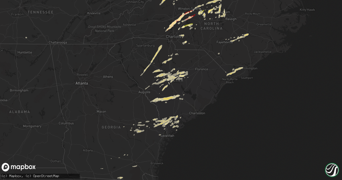
Hail Map in South Carolina on March 24, 2012
Get this storm
March 24 map
$229
one time, instant access
Download today. No call, no setup
Keep the $229
Bought the map and want the full workflow? Apply the entire $229 to a subscription within 7 days. None of it is wasted.
Every map, not just this one
This buys you this map. Subscription and you get every map we run, in the markets you choose from a few cities to whole states to nationwide. Plus real-time alerts the moment a storm fires.
Contact data
Name, contact info, occupancy, even credit band for addresses in the footprint. You go from where it hit to who to call.
Become the source they trust
Unlimited branding weather history reports on demand. You already have the documented answer ready for the property owner, and you are the one who showed up with it.
Property data and RoofTrace estimates
Pull up any address you have got, its value and the exact code rules for that jurisdiction, straight from One Click Code. Then RoofTrace estimates the squares, pitch, and roof value, priced the way you price.
Storm reports in South Carolina
South Carolina
| Date | Description |
|---|---|
| 03/24/20126:43 PM CDT | Quarter size hail reported at mcentire air national guard station near eastover. |
| 03/24/20126:00 PM CDT | Public reported nickel to quarter size hail near pelion. |
| 03/24/20125:40 PM CDT | Dime to quarter size hail at the intersection of park road and old cherokee road. |
| 03/24/20125:40 PM CDT | Quarter size hail reported at walmart along bush river road. |
| 03/24/20125:25 PM CDT | Spotter reported hail just east of gilbert along highway 1. |
| 03/24/20125:20 PM CDT | Quarter size hail reported between gilbert and lexington. |
| 03/24/20125:19 PM CDT | Highway patrol reported power lines down near the intersection of st. Peters church road and hwy 378. |
| 03/24/20125:12 PM CDT | Highway patrol reported a tree in the roadway in the 300 block of maxie road. |
| 03/24/20125:04 PM CDT | Sheriff dispatch reported a tree down on edgeport drive near lancaster. |
| 03/24/20125:03 PM CDT | Quarter size hail reported in gilbert. |
| 03/24/20125:03 PM CDT | Quarter size hail reported just north of lexington covering the ground. |
| 03/24/20124:52 PM CDT | Public reported hail up to quarter size along heritage road. |
| 03/24/20124:43 PM CDT | Wis-tv reported quarter size hail in chapin. |
| 03/24/20124:12 PM CDT | Half dollar sized hail. Hail covering the ground. |
| 03/24/20123:55 PM CDT | Spotter reported hail covering ground quarter size |
| 03/24/20123:50 PM CDT | Quarter size hail covering the ground just northwest of whitemire off of lovers lane. |
| 03/24/20123:48 PM CDT | Nickel to quarter size hail in whitemire. |
| 03/24/20123:39 PM CDT | Nickel to quarter size hail along the east shore of lake greenwood along riviera road. |
| 03/24/20123:18 PM CDT | York electric company says trees brought down powerlines on burris road south of sharon. |
| 03/24/20122:39 PM CDT | Nickel to quarter size hail along the east shore of lake greenwood along riviera road. |
| 03/24/20121:46 PM CDT | Convenience store reported quarter size hail. The hail covered the ground of some of the homes nearby. |
| 03/24/20121:35 PM CDT | Several trees down in the vicinity of lands end road and tuck in the woods. Time estimated based on radar. |
| 03/24/20121:05 PM CDT | One tree reported down along interstate 95 near mile marker 10. Time estimated by radar. |
| 03/24/201212:57 PM CDT | One tree down on interstate 95. Time estimated by radar. |
| 03/24/201212:44 PM CDT | 911 call center reported several trees down on grays highway outside of ridgeland. Time estimated by radar. |
| 03/23/20129:00 PM CDT | Quarter sized hail reported in bamberg by sheriff. |
| 03/23/20129:00 PM CDT | Several trees down in bamberg city limits reported by sheriff. |
| 03/23/20128:26 PM CDT | Public reported quarter size hail just north of branchville on middle road. Hail fell for approximately 20 minutes. |
| 03/23/20128:04 PM CDT | Sheriff dispatch reported a tree down in the canaan community. |
| 03/23/20127:48 PM CDT | Sheriff dispatch reported nickel to quarter size hail along highway 301 southwest of the city of bamberg. |
| 03/23/20127:28 PM CDT | Cooperative observer reported quarter size hail just south of hilda. |
| 03/23/20127:20 PM CDT | Cocorahs observer reported quarter size hail near the sweetwater golf club. |
| 03/23/20127:14 PM CDT | Sheriff dispatch reported quarter size hail at the dispatch center in barnwell. |
| 03/23/20127:10 PM CDT | Half dollar size hail reported just north of shaw air force base. |
All States Impacted by Hail Map on March 24, 2012
Cities Impacted by Hail Map on March 24, 2012
- Woodlawn, VA
- Columbia, SC
- Elgin, SC
- Leesville, SC
- Batesburg, SC
- Collins, GA
- Claxton, GA
- Lyons, GA
- Vidalia, GA
- Jonesville, NC
- Rockwell, NC
- Newton Grove, NC
- Clinton, NC
- Staffordsville, VA
- Ripplemead, VA
- Pearisburg, VA
- Pembroke, VA
- Narrows, VA
- Bland, VA
- Rembert, SC
- Dalzell, SC
- Richfield, NC
- Spencer, VA
- Martinsville, VA
- Huddleston, VA
- Bedford, VA
- Moneta, VA
- Stuart, VA
- Lambsburg, VA
- Sandy Level, VA
- Penhook, VA
- Rocky Mount, VA
- Bassett, VA
- Forest, VA
- Appomattox, VA
- Glade Valley, NC
- Woolwine, VA
- Galax, VA
- Laurel Fork, VA
- Henry, VA
- Lynchburg, VA
- Meadows Of Dan, VA
- Laurel Springs, NC
- Concord, VA
- Lowgap, NC
- Callaway, VA
- Ferrum, VA
- Spout Spring, VA
- Fancy Gap, VA
- Millers Creek, NC
- Hillsville, VA
- Ararat, VA
- Lynch Station, VA
- Cana, VA
- Union Hall, VA
- Willis, VA
- Evington, VA
- Sparta, NC
- Hays, NC
- Dugspur, VA
- Claudville, VA
- Wirtz, VA
- Ennice, NC
- McGrady, NC
- Mount Airy, NC
- Glade Hill, VA
- Rustburg, VA
- Chatham, VA
- Sumter, SC
- Shaw Afb, SC
- Register, GA
- Statesboro, GA
- Lincolnton, NC
- Lugoff, SC
- Nakina, NC
- Tabor City, NC
- Eastover, SC
- Gadsden, SC
- Wedgefield, SC
- Newberry, SC
- Prosperity, SC
- Little Mountain, SC
- Chapin, SC
- Saluda, SC
- Gibsonville, NC
- Crockett, VA
- Wytheville, VA
- Cripple Creek, VA
- Pulaski, VA
- Dublin, VA
- Max Meadows, VA
- Graham, NC
- Concord, NC
- China Grove, NC
- Salisbury, NC
- Midland, NC
- Monroe, NC
- Stanfield, NC
- Marshville, NC
- Sharon, SC
- Lancaster, SC
- Dobson, NC
- Beaufort, SC
- Seabrook, SC
- Kinards, SC
- Chappells, SC
- Ninety Six, SC
- Cross Hill, SC
- Silverstreet, SC
- Gretna, VA
- Carrboro, NC
- Chapel Hill, NC
- Denton, NC
- Gold Hill, NC
- Rural Retreat, VA
- Speedwell, VA
- Cleveland, NC
- Mount Ulla, NC
- Troutman, NC
- Mooresville, NC
- Hillsborough, NC
- Scottsville, VA
- Dillwyn, VA
- Garnett, SC
- Tillman, SC
- Ararat, NC
- Amherstdale, WV
- Yolyn, WV
- Okatie, SC
- Whitsett, NC
- Keeling, VA
- Java, VA
- Callands, VA
- Dry Fork, VA
- Axton, VA
- Danville, VA
- Blairs, VA
- Troy, SC
- Woodleaf, NC
- Ash, NC
- Blair, SC
- Winnsboro, SC
- Sanderson, FL
- Forks, WA
- Sekiu, WA
- Clallam Bay, WA
- Terrell, NC
- Iron Station, NC
- Statesville, NC
- Sherrills Ford, NC
- Denver, NC
- Hardeeville, SC
- Ridgeland, SC
- Swansea, SC
- Elon, NC
- Reidsville, NC
- Burlington, NC
- Hurdle Mills, NC
- Prospect Hill, NC
- Yanceyville, NC
- Roxboro, NC
- Leasburg, NC
- Mebane, NC
- Collinsville, VA
- Fieldale, VA
- Browns Summit, NC
- Atkins, VA
- Marion, VA
- Union, SC
- Lawsonville, NC
- Dunn, NC
- Altavista, VA
- Hurt, VA
- Floyd, VA
- Purlear, NC
- Elkin, NC
- Pittsville, VA
- Gladstone, VA
- Gladys, VA
- Long Island, VA
- Advance, NC
- Mocksville, NC
- Cooleemee, NC
- Clay, WV
- Patrick Springs, VA
- Troy, NC
- Barnwell, SC
- Yemassee, SC
- Bickmore, WV
- Indore, WV
- Lexington, SC
- Liberty, NC
- Climax, NC
- Franklinville, NC
- Julian, NC
- Pleasant Garden, NC
- Gaston, SC
- Cayce, SC
- West Columbia, SC
- Hopkins, SC
- Buckingham, VA
- Vernon Hill, VA
- Nathalie, VA
- Snow Camp, NC
- Haw River, NC
- Efland, NC
- Green Pond, SC
- Winston Salem, NC
- Dallas, NC
- Lexington, NC
- Clemmons, NC
- Alexis, NC
- Ellabell, GA
- Bloomingdale, GA
- Mount Olive, NC
- Faison, NC
- Autryville, NC
- Salemburg, NC
- Dudley, NC
- Stedman, NC
- Roseboro, NC
- Goldsboro, NC
- Gilbert, SC
- Blackstock, SC
- Great Falls, SC
- Glenwood, GA
- Kernersville, NC
- Colfax, NC
- Ramseur, NC
- Bowman, SC
- High Point, NC
- Randleman, NC
- Greensboro, NC
- Duck, WV
- Lizemores, WV
- Wingate, NC
- Rowesville, SC
- Martin, SC
- Blackville, SC
- Bamberg, SC
- Branchville, SC
- Cope, SC
- Olar, SC
- Denmark, SC
- Pelion, SC
- Wagener, SC
- Salley, SC
- Bolton, NC
- Troutdale, VA
- Kannapolis, NC
- Port Royal, SC
- Pineland, SC
- Guyton, GA
- Clyo, GA
- Springfield, GA
- Cowen, WV
- Nicholls, GA
- Halifax, VA
- South Boston, VA
- Whitmire, SC
- York, SC
- Carlisle, SC
- Chester, SC
- Clinton, SC
- Lockhart, SC
- Howardsville, VA
- Summerfield, NC
- Twin City, GA
- Metter, GA
- Durham, NC
- Sheldon, SC
- Estill, SC
- Newington, GA
- Brooklet, GA
- Rincon, GA
- Locust, NC
- Pearson, GA
- Longs, SC
- Delco, NC
- Loris, SC
- Leland, NC
- Ceres, VA
- Thurmond, NC
- Barney, GA
- Arvonia, VA
- Richburg, SC
- Mountain City, TN
- New London, NC
- Sylvania, GA
- Neeses, SC
- North, SC
- Ailey, GA
- Early Branch, SC
- Lumberton, NC
- Pembroke, NC
- Saint George, GA
- Peachland, NC
- Polkton, NC
- Fargo, GA
- Soperton, GA
- Swainsboro, GA
- Springfield, SC
- Rougemont, NC
- Elk Creek, VA
- Siler City, NC
- Cobbtown, GA
- Old Town, FL
- Cross City, FL
- Harrisburg, NC
- Timberlake, NC
- Cedar Grove, NC
- Linwood, NC
- Thomasville, NC
- Alapaha, GA
- Fayetteville, TN
- Whiteville, NC
- Homosassa, FL
- Brooksville, FL
- Mims, FL
- Staley, NC
- Parrott, VA
- Ridge Spring, SC
- Aiken, SC
- Bishopville, SC
- Monetta, SC
- Fries, VA
- Ivanhoe, VA
- Hickory Grove, SC
- Bluefield, VA
- Rocky Gap, VA
- Oak Ridge, NC
- Cary, NC
- Morrisville, NC
- Pittsboro, NC
- Apex, NC
- Semora, NC
- Fort Lawn, SC
- Newport, VA
- Greenville, FL
- Perry, FL
- Bluffton, SC
- Godwin, NC
- Chilhowie, VA
- Damascus, VA
- Heath Springs, SC
- Portal, GA
- Sutherlin, VA
- Waynesboro, GA
- Jasper, FL
- Lamont, FL
- State Road, NC
- Holly Hill, SC
- Piney Creek, NC
- Scottville, NC
- Crumpler, NC
- Asheboro, NC
- Charlotte, NC
- Sugar Grove, VA
- Steinhatchee, FL
- Hilton Head Island, SC
- Live Oak, FL
- Bastian, VA
- Tazewell, VA
- Jeffrey, WV
- Clothier, WV
- Wolfcreek, WV
- Harleyville, SC
- Dorchester, SC
- Saint George, SC
- Wade, NC
- Fayetteville, NC
- North Augusta, SC
- Graniteville, SC
- Pavo, GA
- Trenton, SC
- Princeton, WV
- Montcalm, WV
- Kegley, WV
- Rock, WV
- Bluefield, WV
- Waycross, GA
- Williston, SC
- Stanley, NC


