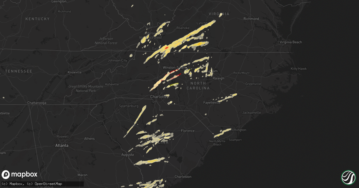
Hail Map in North Carolina on March 24, 2012
Get this storm
March 24 map
$229
one time, instant access
Download today. No call, no setup
Keep the $229
Bought the map and want the full workflow? Apply the entire $229 to a subscription within 7 days. None of it is wasted.
Every map, not just this one
This buys you this map. Subscription and you get every map we run, in the markets you choose from a few cities to whole states to nationwide. Plus real-time alerts the moment a storm fires.
Contact data
Name, contact info, occupancy, even credit band for addresses in the footprint. You go from where it hit to who to call.
Become the source they trust
Unlimited branding weather history reports on demand. You already have the documented answer ready for the property owner, and you are the one who showed up with it.
Property data and RoofTrace estimates
Pull up any address you have got, its value and the exact code rules for that jurisdiction, straight from One Click Code. Then RoofTrace estimates the squares, pitch, and roof value, priced the way you price.
Storm reports in North Carolina
North Carolina
| Date | Description |
|---|---|
| 03/24/20126:58 PM CDT | Quarter size hail at 720 north madison in roxboro |
| 03/24/20126:54 PM CDT | 1 inch hail was observed for 30 seconds. |
| 03/24/20126:51 PM CDT | Tree down at wagstaff carver road |
| 03/24/20126:49 PM CDT | Half dollar size hail in burlington |
| 03/24/20126:40 PM CDT | Quarter sized hail near liberty road and 421 |
| 03/24/20126:25 PM CDT | Tree on a house at 3465 fairview farm road near liberty |
| 03/24/20126:20 PM CDT | Quarter sized hail in hillsborough |
| 03/24/20126:18 PM CDT | Cocorahs report of hail up to the size of quarters. Hail covering the ground. |
| 03/24/20126:15 PM CDT | 911 center reports quarter size hail in hillsborough on meadowlands drive and route 70a |
| 03/24/20126:10 PM CDT | Fire dept responded to a tree blown down across hwy 52 just north of ansonville |
| 03/24/20126:05 PM CDT | A local report indicates 1.00 inch wind near CHERRY GROVE |
| 03/24/20125:40 PM CDT | Quarter sized hail at old randleman road and highway 220 |
| 03/24/20125:23 PM CDT | Two large trees down at olive branch rd and old gold mine rd. |
| 03/24/20125:22 PM CDT | Tree down at bass chapel road and netfield road... Time estimated by radar |
| 03/24/20125:20 PM CDT | Two trees down in locust |
| 03/24/20125:00 PM CDT | A local report indicates 1.00 inch wind near 2 WSW PIEDMONT TRIAD AI |
| 03/24/20124:51 PM CDT | A local report indicates 1.00 inch wind near 1 NW ROCKWELL |
| 03/24/20124:45 PM CDT | 1 inch hail in lexington |
| 03/24/20124:20 PM CDT | Hail fell for several minutes |
| 03/24/20123:50 PM CDT | Hail fell for about 7 minutes |
| 03/24/20123:42 PM CDT | The raleigh weather office relaying another quarter sized hail report 2 miles east of mocksville along highway 64 and reported by a storm chaser. |
| 03/24/20123:40 PM CDT | The raleigh weather office relayed a report of quarter sized hail which started in mocksville at 440 pm and was continuing during the call. |
| 03/24/20123:29 PM CDT | A local report indicates 1.00 inch wind near MOORESVILLE |
| 03/24/20123:20 PM CDT | A local report indicates 1.00 inch wind near 1 N SWANCREEK |
| 03/24/20123:20 PM CDT | Quarter-sized hail at brawley school rd and williamson rd. |
| 03/24/20123:08 PM CDT | Car had windshield busted out by hail while driving on east pine street. |
| 03/24/20122:24 PM CDT | A local report indicates 1.25 inch wind near 3 ENE GLADE VALLEY |
| 03/24/20122:18 PM CDT | Nickel to quarter size hail lasted approximately 2 minutes |
| 03/24/20121:51 PM CDT | A local report indicates 1.00 inch wind near PIREWAY |
| 03/24/20123:55 AM CDT | Relative of nws employee reported hail up to quarter sized. |
| 03/24/20123:17 AM CDT | Deputy reported hail up to golf ball size. |
| 03/24/20123:13 AM CDT | Hail depth on the ground was 6 to 8 inches. |
| 03/24/20122:53 AM CDT | Hail 10 inches deep with drifts up to 3 feet deep. Most hail was marble to dime size. |
| 03/24/20122:25 AM CDT | Hail covered the ground up to golf ball sized |
| 03/24/201212:46 AM CDT | Shingles blown off cafe roof and 150 ft of canopy was ripped from high winds. |
| 03/23/20127:14 PM CDT | Quarter size hail at the flying j |
| 03/23/20127:01 PM CDT | One inch hail in graham |
All States Impacted by Hail Map on March 24, 2012
Cities Impacted by Hail Map on March 24, 2012
- Woodlawn, VA
- Columbia, SC
- Elgin, SC
- Leesville, SC
- Batesburg, SC
- Collins, GA
- Claxton, GA
- Lyons, GA
- Vidalia, GA
- Jonesville, NC
- Rockwell, NC
- Newton Grove, NC
- Clinton, NC
- Staffordsville, VA
- Ripplemead, VA
- Pearisburg, VA
- Pembroke, VA
- Narrows, VA
- Bland, VA
- Rembert, SC
- Dalzell, SC
- Richfield, NC
- Spencer, VA
- Martinsville, VA
- Huddleston, VA
- Bedford, VA
- Moneta, VA
- Stuart, VA
- Lambsburg, VA
- Sandy Level, VA
- Penhook, VA
- Rocky Mount, VA
- Bassett, VA
- Forest, VA
- Appomattox, VA
- Glade Valley, NC
- Woolwine, VA
- Galax, VA
- Laurel Fork, VA
- Henry, VA
- Lynchburg, VA
- Meadows Of Dan, VA
- Laurel Springs, NC
- Concord, VA
- Lowgap, NC
- Callaway, VA
- Ferrum, VA
- Spout Spring, VA
- Fancy Gap, VA
- Millers Creek, NC
- Hillsville, VA
- Ararat, VA
- Lynch Station, VA
- Cana, VA
- Union Hall, VA
- Willis, VA
- Evington, VA
- Sparta, NC
- Hays, NC
- Dugspur, VA
- Claudville, VA
- Wirtz, VA
- Ennice, NC
- McGrady, NC
- Mount Airy, NC
- Glade Hill, VA
- Rustburg, VA
- Chatham, VA
- Sumter, SC
- Shaw Afb, SC
- Register, GA
- Statesboro, GA
- Lincolnton, NC
- Lugoff, SC
- Nakina, NC
- Tabor City, NC
- Eastover, SC
- Gadsden, SC
- Wedgefield, SC
- Newberry, SC
- Prosperity, SC
- Little Mountain, SC
- Chapin, SC
- Saluda, SC
- Gibsonville, NC
- Crockett, VA
- Wytheville, VA
- Cripple Creek, VA
- Pulaski, VA
- Dublin, VA
- Max Meadows, VA
- Graham, NC
- Concord, NC
- China Grove, NC
- Salisbury, NC
- Midland, NC
- Monroe, NC
- Stanfield, NC
- Marshville, NC
- Sharon, SC
- Lancaster, SC
- Dobson, NC
- Beaufort, SC
- Seabrook, SC
- Kinards, SC
- Chappells, SC
- Ninety Six, SC
- Cross Hill, SC
- Silverstreet, SC
- Gretna, VA
- Carrboro, NC
- Chapel Hill, NC
- Denton, NC
- Gold Hill, NC
- Rural Retreat, VA
- Speedwell, VA
- Cleveland, NC
- Mount Ulla, NC
- Troutman, NC
- Mooresville, NC
- Hillsborough, NC
- Scottsville, VA
- Dillwyn, VA
- Garnett, SC
- Tillman, SC
- Ararat, NC
- Amherstdale, WV
- Yolyn, WV
- Okatie, SC
- Whitsett, NC
- Keeling, VA
- Java, VA
- Callands, VA
- Dry Fork, VA
- Axton, VA
- Danville, VA
- Blairs, VA
- Troy, SC
- Woodleaf, NC
- Ash, NC
- Blair, SC
- Winnsboro, SC
- Sanderson, FL
- Forks, WA
- Sekiu, WA
- Clallam Bay, WA
- Terrell, NC
- Iron Station, NC
- Statesville, NC
- Sherrills Ford, NC
- Denver, NC
- Hardeeville, SC
- Ridgeland, SC
- Swansea, SC
- Elon, NC
- Reidsville, NC
- Burlington, NC
- Hurdle Mills, NC
- Prospect Hill, NC
- Yanceyville, NC
- Roxboro, NC
- Leasburg, NC
- Mebane, NC
- Collinsville, VA
- Fieldale, VA
- Browns Summit, NC
- Atkins, VA
- Marion, VA
- Union, SC
- Lawsonville, NC
- Dunn, NC
- Altavista, VA
- Hurt, VA
- Floyd, VA
- Purlear, NC
- Elkin, NC
- Pittsville, VA
- Gladstone, VA
- Gladys, VA
- Long Island, VA
- Advance, NC
- Mocksville, NC
- Cooleemee, NC
- Clay, WV
- Patrick Springs, VA
- Troy, NC
- Barnwell, SC
- Yemassee, SC
- Bickmore, WV
- Indore, WV
- Lexington, SC
- Liberty, NC
- Climax, NC
- Franklinville, NC
- Julian, NC
- Pleasant Garden, NC
- Gaston, SC
- Cayce, SC
- West Columbia, SC
- Hopkins, SC
- Buckingham, VA
- Vernon Hill, VA
- Nathalie, VA
- Snow Camp, NC
- Haw River, NC
- Efland, NC
- Green Pond, SC
- Winston Salem, NC
- Dallas, NC
- Lexington, NC
- Clemmons, NC
- Alexis, NC
- Ellabell, GA
- Bloomingdale, GA
- Mount Olive, NC
- Faison, NC
- Autryville, NC
- Salemburg, NC
- Dudley, NC
- Stedman, NC
- Roseboro, NC
- Goldsboro, NC
- Gilbert, SC
- Blackstock, SC
- Great Falls, SC
- Glenwood, GA
- Kernersville, NC
- Colfax, NC
- Ramseur, NC
- Bowman, SC
- High Point, NC
- Randleman, NC
- Greensboro, NC
- Duck, WV
- Lizemores, WV
- Wingate, NC
- Rowesville, SC
- Martin, SC
- Blackville, SC
- Bamberg, SC
- Branchville, SC
- Cope, SC
- Olar, SC
- Denmark, SC
- Pelion, SC
- Wagener, SC
- Salley, SC
- Bolton, NC
- Troutdale, VA
- Kannapolis, NC
- Port Royal, SC
- Pineland, SC
- Guyton, GA
- Clyo, GA
- Springfield, GA
- Cowen, WV
- Nicholls, GA
- Halifax, VA
- South Boston, VA
- Whitmire, SC
- York, SC
- Carlisle, SC
- Chester, SC
- Clinton, SC
- Lockhart, SC
- Howardsville, VA
- Summerfield, NC
- Twin City, GA
- Metter, GA
- Durham, NC
- Sheldon, SC
- Estill, SC
- Newington, GA
- Brooklet, GA
- Rincon, GA
- Locust, NC
- Pearson, GA
- Longs, SC
- Delco, NC
- Loris, SC
- Leland, NC
- Ceres, VA
- Thurmond, NC
- Barney, GA
- Arvonia, VA
- Richburg, SC
- Mountain City, TN
- New London, NC
- Sylvania, GA
- Neeses, SC
- North, SC
- Ailey, GA
- Early Branch, SC
- Lumberton, NC
- Pembroke, NC
- Saint George, GA
- Peachland, NC
- Polkton, NC
- Fargo, GA
- Soperton, GA
- Swainsboro, GA
- Springfield, SC
- Rougemont, NC
- Elk Creek, VA
- Siler City, NC
- Cobbtown, GA
- Old Town, FL
- Cross City, FL
- Harrisburg, NC
- Timberlake, NC
- Cedar Grove, NC
- Linwood, NC
- Thomasville, NC
- Alapaha, GA
- Fayetteville, TN
- Whiteville, NC
- Homosassa, FL
- Brooksville, FL
- Mims, FL
- Staley, NC
- Parrott, VA
- Ridge Spring, SC
- Aiken, SC
- Bishopville, SC
- Monetta, SC
- Fries, VA
- Ivanhoe, VA
- Hickory Grove, SC
- Bluefield, VA
- Rocky Gap, VA
- Oak Ridge, NC
- Cary, NC
- Morrisville, NC
- Pittsboro, NC
- Apex, NC
- Semora, NC
- Fort Lawn, SC
- Newport, VA
- Greenville, FL
- Perry, FL
- Bluffton, SC
- Godwin, NC
- Chilhowie, VA
- Damascus, VA
- Heath Springs, SC
- Portal, GA
- Sutherlin, VA
- Waynesboro, GA
- Jasper, FL
- Lamont, FL
- State Road, NC
- Holly Hill, SC
- Piney Creek, NC
- Scottville, NC
- Crumpler, NC
- Asheboro, NC
- Charlotte, NC
- Sugar Grove, VA
- Steinhatchee, FL
- Hilton Head Island, SC
- Live Oak, FL
- Bastian, VA
- Tazewell, VA
- Jeffrey, WV
- Clothier, WV
- Wolfcreek, WV
- Harleyville, SC
- Dorchester, SC
- Saint George, SC
- Wade, NC
- Fayetteville, NC
- North Augusta, SC
- Graniteville, SC
- Pavo, GA
- Trenton, SC
- Princeton, WV
- Montcalm, WV
- Kegley, WV
- Rock, WV
- Bluefield, WV
- Waycross, GA
- Williston, SC
- Stanley, NC


