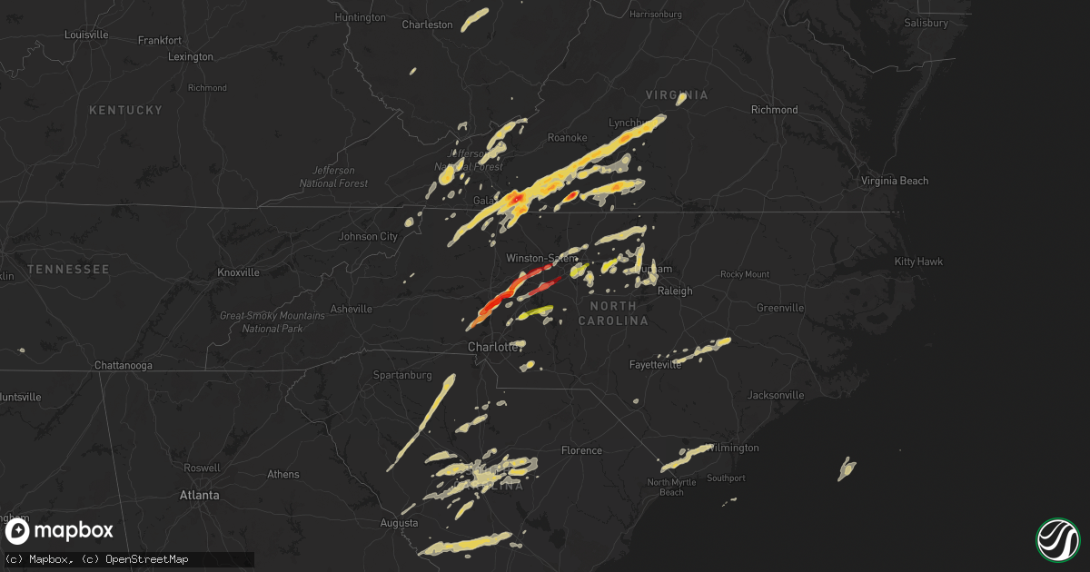
Hail Map on March 24, 2012
Get this storm
March 24 map
$229
one time, instant access
Download today. No call, no setup
Keep the $229
Bought the map and want the full workflow? Apply the entire $229 to a subscription within 7 days. None of it is wasted.
Every map, not just this one
This buys you this map. Subscription and you get every map we run, in the markets you choose from a few cities to whole states to nationwide. Plus real-time alerts the moment a storm fires.
Contact data
Name, contact info, occupancy, even credit band for addresses in the footprint. You go from where it hit to who to call.
Become the source they trust
Unlimited branding weather history reports on demand. You already have the documented answer ready for the property owner, and you are the one who showed up with it.
Property data and RoofTrace estimates
Pull up any address you have got, its value and the exact code rules for that jurisdiction, straight from One Click Code. Then RoofTrace estimates the squares, pitch, and roof value, priced the way you price.
States Impacted by Hail Map on March 24, 2012
Storm reports
South Carolina
| Date | Description |
|---|---|
| 03/24/20126:43 PM CDT | Quarter size hail reported at mcentire air national guard station near eastover. |
| 03/24/20126:00 PM CDT | Public reported nickel to quarter size hail near pelion. |
| 03/24/20125:40 PM CDT | Quarter size hail reported at walmart along bush river road. |
| 03/24/20125:40 PM CDT | Dime to quarter size hail at the intersection of park road and old cherokee road. |
| 03/24/20125:25 PM CDT | Spotter reported hail just east of gilbert along highway 1. |
| 03/24/20125:20 PM CDT | Quarter size hail reported between gilbert and lexington. |
| 03/24/20125:19 PM CDT | Highway patrol reported power lines down near the intersection of st. Peters church road and hwy 378. |
| 03/24/20125:12 PM CDT | Highway patrol reported a tree in the roadway in the 300 block of maxie road. |
| 03/24/20125:04 PM CDT | Sheriff dispatch reported a tree down on edgeport drive near lancaster. |
| 03/24/20125:03 PM CDT | Quarter size hail reported in gilbert. |
| 03/24/20125:03 PM CDT | Quarter size hail reported just north of lexington covering the ground. |
| 03/24/20124:52 PM CDT | Public reported hail up to quarter size along heritage road. |
| 03/24/20124:43 PM CDT | Wis-tv reported quarter size hail in chapin. |
| 03/24/20124:12 PM CDT | Half dollar sized hail. Hail covering the ground. |
| 03/24/20123:55 PM CDT | Spotter reported hail covering ground quarter size |
| 03/24/20123:50 PM CDT | Quarter size hail covering the ground just northwest of whitemire off of lovers lane. |
| 03/24/20123:48 PM CDT | Nickel to quarter size hail in whitemire. |
| 03/24/20123:39 PM CDT | Nickel to quarter size hail along the east shore of lake greenwood along riviera road. |
| 03/24/20123:18 PM CDT | York electric company says trees brought down powerlines on burris road south of sharon. |
| 03/24/20122:39 PM CDT | Nickel to quarter size hail along the east shore of lake greenwood along riviera road. |
| 03/24/20121:46 PM CDT | Convenience store reported quarter size hail. The hail covered the ground of some of the homes nearby. |
| 03/24/20121:35 PM CDT | Several trees down in the vicinity of lands end road and tuck in the woods. Time estimated based on radar. |
| 03/24/20121:05 PM CDT | One tree reported down along interstate 95 near mile marker 10. Time estimated by radar. |
| 03/24/201212:57 PM CDT | One tree down on interstate 95. Time estimated by radar. |
| 03/24/201212:44 PM CDT | 911 call center reported several trees down on grays highway outside of ridgeland. Time estimated by radar. |
| 03/23/20129:00 PM CDT | Several trees down in bamberg city limits reported by sheriff. |
| 03/23/20129:00 PM CDT | Quarter sized hail reported in bamberg by sheriff. |
| 03/23/20128:26 PM CDT | Public reported quarter size hail just north of branchville on middle road. Hail fell for approximately 20 minutes. |
| 03/23/20128:04 PM CDT | Sheriff dispatch reported a tree down in the canaan community. |
| 03/23/20127:48 PM CDT | Sheriff dispatch reported nickel to quarter size hail along highway 301 southwest of the city of bamberg. |
| 03/23/20127:28 PM CDT | Cooperative observer reported quarter size hail just south of hilda. |
| 03/23/20127:20 PM CDT | Cocorahs observer reported quarter size hail near the sweetwater golf club. |
| 03/23/20127:14 PM CDT | Sheriff dispatch reported quarter size hail at the dispatch center in barnwell. |
| 03/23/20127:10 PM CDT | Half dollar size hail reported just north of shaw air force base. |
North Carolina
| Date | Description |
|---|---|
| 03/24/20126:58 PM CDT | Quarter size hail at 720 north madison in roxboro |
| 03/24/20126:54 PM CDT | 1 inch hail was observed for 30 seconds. |
| 03/24/20126:51 PM CDT | Tree down at wagstaff carver road |
| 03/24/20126:49 PM CDT | Half dollar size hail in burlington |
| 03/24/20126:40 PM CDT | Quarter sized hail near liberty road and 421 |
| 03/24/20126:25 PM CDT | Tree on a house at 3465 fairview farm road near liberty |
| 03/24/20126:20 PM CDT | Quarter sized hail in hillsborough |
| 03/24/20126:18 PM CDT | Cocorahs report of hail up to the size of quarters. Hail covering the ground. |
| 03/24/20126:15 PM CDT | 911 center reports quarter size hail in hillsborough on meadowlands drive and route 70a |
| 03/24/20126:10 PM CDT | Fire dept responded to a tree blown down across hwy 52 just north of ansonville |
| 03/24/20126:05 PM CDT | A local report indicates 1.00 inch wind near CHERRY GROVE |
| 03/24/20125:40 PM CDT | Quarter sized hail at old randleman road and highway 220 |
| 03/24/20125:23 PM CDT | Two large trees down at olive branch rd and old gold mine rd. |
| 03/24/20125:22 PM CDT | Tree down at bass chapel road and netfield road... Time estimated by radar |
| 03/24/20125:20 PM CDT | Two trees down in locust |
| 03/24/20125:00 PM CDT | A local report indicates 1.00 inch wind near 2 WSW PIEDMONT TRIAD AI |
| 03/24/20124:51 PM CDT | A local report indicates 1.00 inch wind near 1 NW ROCKWELL |
| 03/24/20124:45 PM CDT | 1 inch hail in lexington |
| 03/24/20124:20 PM CDT | Hail fell for several minutes |
| 03/24/20123:50 PM CDT | Hail fell for about 7 minutes |
| 03/24/20123:42 PM CDT | The raleigh weather office relaying another quarter sized hail report 2 miles east of mocksville along highway 64 and reported by a storm chaser. |
| 03/24/20123:40 PM CDT | The raleigh weather office relayed a report of quarter sized hail which started in mocksville at 440 pm and was continuing during the call. |
| 03/24/20123:29 PM CDT | A local report indicates 1.00 inch wind near MOORESVILLE |
| 03/24/20123:20 PM CDT | A local report indicates 1.00 inch wind near 1 N SWANCREEK |
| 03/24/20123:20 PM CDT | Quarter-sized hail at brawley school rd and williamson rd. |
| 03/24/20123:08 PM CDT | Car had windshield busted out by hail while driving on east pine street. |
| 03/24/20122:24 PM CDT | A local report indicates 1.25 inch wind near 3 ENE GLADE VALLEY |
| 03/24/20122:18 PM CDT | Nickel to quarter size hail lasted approximately 2 minutes |
| 03/24/20121:51 PM CDT | A local report indicates 1.00 inch wind near PIREWAY |
| 03/24/20123:55 AM CDT | Relative of nws employee reported hail up to quarter sized. |
| 03/24/20123:17 AM CDT | Deputy reported hail up to golf ball size. |
| 03/24/20123:13 AM CDT | Hail depth on the ground was 6 to 8 inches. |
| 03/24/20122:53 AM CDT | Hail 10 inches deep with drifts up to 3 feet deep. Most hail was marble to dime size. |
| 03/24/20122:25 AM CDT | Hail covered the ground up to golf ball sized |
| 03/24/201212:46 AM CDT | Shingles blown off cafe roof and 150 ft of canopy was ripped from high winds. |
| 03/23/20127:14 PM CDT | Quarter size hail at the flying j |
| 03/23/20127:01 PM CDT | One inch hail in graham |
Virginia
| Date | Description |
|---|---|
| 03/24/20126:18 PM CDT | A local report indicates 1.75 inch wind near 3 WSW SPRING GARDEN |
| 03/24/20126:15 PM CDT | Trees power lines down |
| 03/24/20126:12 PM CDT | Hail damaged gutters |
| 03/24/20125:54 PM CDT | Located next to tight squeeze plaza shopping center |
| 03/24/20125:52 PM CDT | A local report indicates 1.00 inch wind near 2 S STONEWALL |
| 03/24/20125:45 PM CDT | Hail up to walnut size started at 645pm and lasted until 700pm |
| 03/24/20125:35 PM CDT | Located on old well road |
| 03/24/20125:25 PM CDT | A local report indicates 1.00 inch wind near 1 ESE GREEN MEADOWS |
| 03/24/20125:22 PM CDT | A local report indicates 1.00 inch wind near 2 SE LAUREL FORK |
| 03/24/20125:15 PM CDT | A local report indicates 1.50 inch wind near 3 SSE ELAMSVILLE |
| 03/24/20125:15 PM CDT | Hail damaged the siding... Broke one window... And several window screens on a home. |
| 03/24/20125:15 PM CDT | A local report indicates 1.00 inch wind near 2 NE EVINGTON |
| 03/24/20125:15 PM CDT | A local report indicates 1.00 inch wind near ROCKY MOUNT |
| 03/24/20125:08 PM CDT | A local report indicates 2.50 inch wind near 2 NE MARTINSVILLE CITY |
| 03/24/20125:07 PM CDT | A local report indicates 2.00 inch wind near HILLTOP |
| 03/24/20125:00 PM CDT | A local report indicates 1.00 inch wind near HENRY |
| 03/24/20124:58 PM CDT | A local report indicates 1.75 inch wind near HEUSLEY |
| 03/24/20124:57 PM CDT | A local report indicates 1.50 inch wind near 5 E ROCKY MOUNT |
| 03/24/20124:55 PM CDT | A local report indicates 1.75 inch wind near 1 ESE KOEHLER |
| 03/24/20124:50 PM CDT | A local report indicates 2.50 inch wind near 1 W JONES CREEK |
| 03/24/20124:45 PM CDT | A local report indicates 1.75 inch wind near BASSETT |
| 03/24/20124:33 PM CDT | A local report indicates 1.00 inch wind near HUDDLESTON |
| 03/24/20124:30 PM CDT | Hail at least golf-ball size observed on highway 57 |
| 03/24/20124:25 PM CDT | A local report indicates 1.50 inch wind near SCRUGGS |
| 03/24/20124:00 PM CDT | A local report indicates 1.00 inch wind near MONETA |
| 03/24/20123:55 PM CDT | A local report indicates 1.00 inch wind near ROCKY MOUNT |
| 03/24/20123:34 PM CDT | A local report indicates 1.00 inch wind near FERRUM |
| 03/24/20123:20 PM CDT | A local report indicates 1.00 inch wind near 2 S CROOKED OAK |
| 03/24/20123:20 PM CDT | A local report indicates 1.00 inch wind near 2 S CROOKED OAK |
| 03/24/20122:56 PM CDT | Hail covered ground..largest 1 inch diameter |
| 03/24/20122:37 PM CDT | Reported at ripplemead |
| 03/24/20122:35 PM CDT | A local report indicates 1.00 inch wind near MEADOWS OF DAN |
| 03/24/20122:30 PM CDT | A local report indicates 1.00 inch wind near 1 N PROSPECTDALE |
| 03/24/20122:15 PM CDT | A local report indicates 1.00 inch wind near 2 NNW WURNO |
| 03/24/20122:14 PM CDT | Reported along blue ridge parkway on carroll/patrick county line. Windows broken in home. |
| 03/24/20122:07 PM CDT | A local report indicates 1.25 inch wind near CANA |
| 03/24/20121:50 PM CDT | A local report indicates 1.00 inch wind near 1 SSW CANA |
| 03/24/20121:15 PM CDT | A local report indicates 1.00 inch wind near HILDRETHS HOUSE |
| 03/24/20121:15 PM CDT | A local report indicates 1.50 inch wind near RURAL RETREAT |
| 03/24/201212:38 PM CDT | A local report indicates 1.00 inch wind near 5 SW MARION |
| 03/23/20128:23 PM CDT | A local report indicates 1.00 inch wind near SMITH STORE |
| 03/23/20128:00 PM CDT | A local report indicates 1.00 inch wind near 2 E GLENMORE |
| 03/23/20127:45 PM CDT | Roof damage |
| 03/23/20127:31 PM CDT | A local report indicates 1.00 inch wind near 1 NW APPOMATTOX |
West Virginia
| Date | Description |
|---|---|
| 03/24/20122:36 PM CDT | A local report indicates 1.00 inch wind near DIXIE |
| 03/24/20121:40 PM CDT | A local report indicates 1.00 inch wind near MATOAKA |
Florida
| Date | Description |
|---|---|
| 03/24/20126:00 PM CDT | Several trees down just north of the nw 130th street and nw 20th avenue intersection. |
| 03/24/20125:31 PM CDT | Several oak trees...branches and power lines down at restaurant near u.s. 19 and cr 320. No injuries. |
| 03/24/20122:05 PM CDT | State warning point relayed report of carport damage and trees down at nw 196th terrace. |
| 03/24/201210:15 AM CDT | Horse barn roof blown off by strong thunderstorm winds. |
| 03/24/20129:35 AM CDT | Estimated wind gust between 60-70 miles an hour. Rainfall estimated at 2 inches in 12 minutes with fast moving thunderstorm. Driveway flooded. |
Tennessee
| Date | Description |
|---|---|
| 03/24/20124:22 PM CDT | A local report indicates 1.00 inch wind near 1 SE HOWELL |
Georgia
| Date | Description |
|---|---|
| 03/24/201211:35 AM CDT | Effingham county fire department station reported quarter size hail. Time was estimated from radar. |
| 03/24/201211:25 AM CDT | Thunderstorm winds blew a tree down onto state route 292. |
| 03/24/201210:30 AM CDT | On columbus road a large cypress tree fell on a circuit knocking out power to customers on the circuit. |
| 03/23/20128:41 PM CDT | A couple of trees reported down along clito road. |
| 03/23/20128:41 PM CDT | One tree down along stillwater drive. |
Cities Impacted by Hail Map on March 24, 2012
- Woodlawn, VA
- Columbia, SC
- Elgin, SC
- Leesville, SC
- Batesburg, SC
- Collins, GA
- Claxton, GA
- Lyons, GA
- Vidalia, GA
- Jonesville, NC
- Rockwell, NC
- Newton Grove, NC
- Clinton, NC
- Staffordsville, VA
- Ripplemead, VA
- Pearisburg, VA
- Pembroke, VA
- Narrows, VA
- Bland, VA
- Rembert, SC
- Dalzell, SC
- Richfield, NC
- Spencer, VA
- Martinsville, VA
- Huddleston, VA
- Bedford, VA
- Moneta, VA
- Stuart, VA
- Lambsburg, VA
- Sandy Level, VA
- Penhook, VA
- Rocky Mount, VA
- Bassett, VA
- Forest, VA
- Appomattox, VA
- Glade Valley, NC
- Woolwine, VA
- Galax, VA
- Laurel Fork, VA
- Henry, VA
- Lynchburg, VA
- Meadows Of Dan, VA
- Laurel Springs, NC
- Concord, VA
- Lowgap, NC
- Callaway, VA
- Ferrum, VA
- Spout Spring, VA
- Fancy Gap, VA
- Millers Creek, NC
- Hillsville, VA
- Ararat, VA
- Lynch Station, VA
- Cana, VA
- Union Hall, VA
- Willis, VA
- Evington, VA
- Sparta, NC
- Hays, NC
- Dugspur, VA
- Claudville, VA
- Wirtz, VA
- Ennice, NC
- McGrady, NC
- Mount Airy, NC
- Glade Hill, VA
- Rustburg, VA
- Chatham, VA
- Sumter, SC
- Shaw Afb, SC
- Register, GA
- Statesboro, GA
- Lincolnton, NC
- Lugoff, SC
- Nakina, NC
- Tabor City, NC
- Eastover, SC
- Gadsden, SC
- Wedgefield, SC
- Newberry, SC
- Prosperity, SC
- Little Mountain, SC
- Chapin, SC
- Saluda, SC
- Gibsonville, NC
- Crockett, VA
- Wytheville, VA
- Cripple Creek, VA
- Pulaski, VA
- Dublin, VA
- Max Meadows, VA
- Graham, NC
- Concord, NC
- China Grove, NC
- Salisbury, NC
- Midland, NC
- Monroe, NC
- Stanfield, NC
- Marshville, NC
- Sharon, SC
- Lancaster, SC
- Dobson, NC
- Beaufort, SC
- Seabrook, SC
- Kinards, SC
- Chappells, SC
- Ninety Six, SC
- Cross Hill, SC
- Silverstreet, SC
- Gretna, VA
- Carrboro, NC
- Chapel Hill, NC
- Denton, NC
- Gold Hill, NC
- Rural Retreat, VA
- Speedwell, VA
- Cleveland, NC
- Mount Ulla, NC
- Troutman, NC
- Mooresville, NC
- Hillsborough, NC
- Scottsville, VA
- Dillwyn, VA
- Garnett, SC
- Tillman, SC
- Ararat, NC
- Amherstdale, WV
- Yolyn, WV
- Okatie, SC
- Whitsett, NC
- Keeling, VA
- Java, VA
- Callands, VA
- Dry Fork, VA
- Axton, VA
- Danville, VA
- Blairs, VA
- Troy, SC
- Woodleaf, NC
- Ash, NC
- Blair, SC
- Winnsboro, SC
- Sanderson, FL
- Forks, WA
- Sekiu, WA
- Clallam Bay, WA
- Terrell, NC
- Iron Station, NC
- Statesville, NC
- Sherrills Ford, NC
- Denver, NC
- Hardeeville, SC
- Ridgeland, SC
- Swansea, SC
- Elon, NC
- Reidsville, NC
- Burlington, NC
- Hurdle Mills, NC
- Prospect Hill, NC
- Yanceyville, NC
- Roxboro, NC
- Leasburg, NC
- Mebane, NC
- Collinsville, VA
- Fieldale, VA
- Browns Summit, NC
- Atkins, VA
- Marion, VA
- Union, SC
- Lawsonville, NC
- Dunn, NC
- Altavista, VA
- Hurt, VA
- Floyd, VA
- Purlear, NC
- Elkin, NC
- Pittsville, VA
- Gladstone, VA
- Gladys, VA
- Long Island, VA
- Advance, NC
- Mocksville, NC
- Cooleemee, NC
- Clay, WV
- Patrick Springs, VA
- Troy, NC
- Barnwell, SC
- Yemassee, SC
- Bickmore, WV
- Indore, WV
- Lexington, SC
- Liberty, NC
- Climax, NC
- Franklinville, NC
- Julian, NC
- Pleasant Garden, NC
- Gaston, SC
- Cayce, SC
- West Columbia, SC
- Hopkins, SC
- Buckingham, VA
- Vernon Hill, VA
- Nathalie, VA
- Snow Camp, NC
- Haw River, NC
- Efland, NC
- Green Pond, SC
- Winston Salem, NC
- Dallas, NC
- Lexington, NC
- Clemmons, NC
- Alexis, NC
- Ellabell, GA
- Bloomingdale, GA
- Mount Olive, NC
- Faison, NC
- Autryville, NC
- Salemburg, NC
- Dudley, NC
- Stedman, NC
- Roseboro, NC
- Goldsboro, NC
- Gilbert, SC
- Blackstock, SC
- Great Falls, SC
- Glenwood, GA
- Kernersville, NC
- Colfax, NC
- Ramseur, NC
- Bowman, SC
- High Point, NC
- Randleman, NC
- Greensboro, NC
- Duck, WV
- Lizemores, WV
- Wingate, NC
- Rowesville, SC
- Martin, SC
- Blackville, SC
- Bamberg, SC
- Branchville, SC
- Cope, SC
- Olar, SC
- Denmark, SC
- Pelion, SC
- Wagener, SC
- Salley, SC
- Bolton, NC
- Troutdale, VA
- Kannapolis, NC
- Port Royal, SC
- Pineland, SC
- Guyton, GA
- Clyo, GA
- Springfield, GA
- Cowen, WV
- Nicholls, GA
- Halifax, VA
- South Boston, VA
- Whitmire, SC
- York, SC
- Carlisle, SC
- Chester, SC
- Clinton, SC
- Lockhart, SC
- Howardsville, VA
- Summerfield, NC
- Twin City, GA
- Metter, GA
- Durham, NC
- Sheldon, SC
- Estill, SC
- Newington, GA
- Brooklet, GA
- Rincon, GA
- Locust, NC
- Pearson, GA
- Longs, SC
- Delco, NC
- Loris, SC
- Leland, NC
- Ceres, VA
- Thurmond, NC
- Barney, GA
- Arvonia, VA
- Richburg, SC
- Mountain City, TN
- New London, NC
- Sylvania, GA
- Neeses, SC
- North, SC
- Ailey, GA
- Early Branch, SC
- Lumberton, NC
- Pembroke, NC
- Saint George, GA
- Peachland, NC
- Polkton, NC
- Fargo, GA
- Soperton, GA
- Swainsboro, GA
- Springfield, SC
- Rougemont, NC
- Elk Creek, VA
- Siler City, NC
- Cobbtown, GA
- Old Town, FL
- Cross City, FL
- Harrisburg, NC
- Timberlake, NC
- Cedar Grove, NC
- Linwood, NC
- Thomasville, NC
- Alapaha, GA
- Fayetteville, TN
- Whiteville, NC
- Homosassa, FL
- Brooksville, FL
- Mims, FL
- Staley, NC
- Parrott, VA
- Ridge Spring, SC
- Aiken, SC
- Bishopville, SC
- Monetta, SC
- Fries, VA
- Ivanhoe, VA
- Hickory Grove, SC
- Bluefield, VA
- Rocky Gap, VA
- Oak Ridge, NC
- Cary, NC
- Morrisville, NC
- Pittsboro, NC
- Apex, NC
- Semora, NC
- Fort Lawn, SC
- Newport, VA
- Greenville, FL
- Perry, FL
- Bluffton, SC
- Godwin, NC
- Chilhowie, VA
- Damascus, VA
- Heath Springs, SC
- Portal, GA
- Sutherlin, VA
- Waynesboro, GA
- Jasper, FL
- Lamont, FL
- State Road, NC
- Holly Hill, SC
- Piney Creek, NC
- Scottville, NC
- Crumpler, NC
- Asheboro, NC
- Charlotte, NC
- Sugar Grove, VA
- Steinhatchee, FL
- Hilton Head Island, SC
- Live Oak, FL
- Bastian, VA
- Tazewell, VA
- Jeffrey, WV
- Clothier, WV
- Wolfcreek, WV
- Harleyville, SC
- Dorchester, SC
- Saint George, SC
- Wade, NC
- Fayetteville, NC
- North Augusta, SC
- Graniteville, SC
- Pavo, GA
- Trenton, SC
- Princeton, WV
- Montcalm, WV
- Kegley, WV
- Rock, WV
- Bluefield, WV
- Waycross, GA
- Williston, SC
- Stanley, NC